The RM11 postcode district is a postal district located in the RM Romford postcode area with a population of 32,650 residents according to the 2021 England and Wales Census.
The area of the RM11 postcode district is 3.46 square miles which is 8.97 square kilometres or 2,216.86 acres.
Currently, the RM11 district has about 572 postcode units spread across 3 geographic postcode sectors.
Given that each sector allows for 400 unique postcode combinations, the district has a capacity of 1,200 postcodes. With 572 postcodes already in use, this leaves 628 units available.
The RM11 postal code covers the settlement of HORNCHURCH.
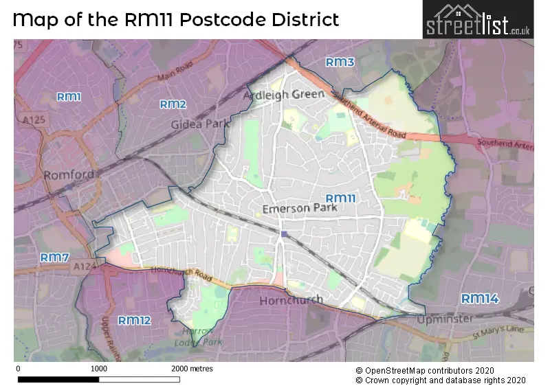
The RM11 Postcode shares a border with RM2 (ROMFORD, GIDEA PARK), RM3 (ROMFORD), RM1 (ROMFORD), RM12 (HORNCHURCH) and RM14 (UPMINSTER, Bulphan, NORTH OCKENDON).
The primary settlement in the RM11 postcode district is Hornchurch, located in the county of Greater London. The most significant Postal Town in the district is Hornchurch.
For the district RM11, we have data on 3 postcode sectors. Here's a breakdown: The sector RM11 1, covers Hornchurch in Greater London. The sector RM11 2, covers Hornchurch in Greater London. The sector RM11 3, covers Hornchurch in Greater London.


Map of the RM11 Postcode District
Explore the RM11 postcode district by using our free interactive map.
When it comes to local government, postal geography often disregards political borders. However, for a breakdown in the RM11 District: the district mostly encompasses the Havering London Boro area with a total of 570 postcodes.
Recent House Sales in RM11
| Date | Price | Address |
|---|---|---|
| 29/09/2023 | £150,000 | Fentiman Way, Hornchurch, RM11 3XY |
| 28/09/2023 | £563,000 | Primrose Glen, Hornchurch, RM11 2NP |
| 27/09/2023 | £566,500 | Ardleigh Green Road, Hornchurch, RM11 2ST |
| 14/09/2023 | £714,000 | Beverley Gardens, Hornchurch, RM11 3NX |
| 11/09/2023 | £710,000 | Wingletye Lane, Hornchurch, RM11 3BU |
| 11/09/2023 | £314,000 | Ashby Close, Hornchurch, RM11 3QR |
| 11/09/2023 | £560,000 | Glebe Way, Hornchurch, RM11 3RR |
| 08/09/2023 | £140,000 | Fentiman Way, Hornchurch, RM11 3XY |
| 08/09/2023 | £296,000 | Claremont Road, Hornchurch, RM11 1BY |
| 05/09/2023 | £800,000 | Ferndown, Emerson Park, Hornchurch, RM11 3JL |
Weather Forecast for RM11
Press Button to Show Forecast for Romford
| Time Period | Icon | Description | Temperature | Rain Probability | Wind |
|---|---|---|---|---|---|
| 09:00 to 12:00 | Cloudy | 8.0°C (feels like 5.0°C) | 4.00% | NNW 13 mph | |
| 12:00 to 15:00 | Cloudy | 10.0°C (feels like 8.0°C) | 4.00% | NNW 13 mph | |
| 15:00 to 18:00 | Cloudy | 11.0°C (feels like 8.0°C) | 5.00% | NNW 11 mph | |
| 18:00 to 21:00 | Cloudy | 9.0°C (feels like 7.0°C) | 4.00% | N 9 mph | |
| 21:00 to 00:00 | Clear night | 7.0°C (feels like 5.0°C) | 1.00% | NE 4 mph |
Press Button to Show Forecast for Romford
| Time Period | Icon | Description | Temperature | Rain Probability | Wind |
|---|---|---|---|---|---|
| 00:00 to 03:00 | Cloudy | 5.0°C (feels like 4.0°C) | 4.00% | WSW 4 mph | |
| 03:00 to 06:00 | Cloudy | 5.0°C (feels like 3.0°C) | 4.00% | WSW 4 mph | |
| 06:00 to 09:00 | Cloudy | 6.0°C (feels like 4.0°C) | 5.00% | WSW 7 mph | |
| 09:00 to 12:00 | Cloudy | 9.0°C (feels like 7.0°C) | 7.00% | W 9 mph | |
| 12:00 to 15:00 | Cloudy | 11.0°C (feels like 9.0°C) | 9.00% | WNW 9 mph | |
| 15:00 to 18:00 | Overcast | 12.0°C (feels like 10.0°C) | 14.00% | WNW 9 mph | |
| 18:00 to 21:00 | Overcast | 10.0°C (feels like 9.0°C) | 14.00% | NW 7 mph | |
| 21:00 to 00:00 | Cloudy | 8.0°C (feels like 6.0°C) | 7.00% | NNE 4 mph |
Press Button to Show Forecast for Romford
| Time Period | Icon | Description | Temperature | Rain Probability | Wind |
|---|---|---|---|---|---|
| 00:00 to 03:00 | Cloudy | 6.0°C (feels like 5.0°C) | 4.00% | NE 4 mph | |
| 03:00 to 06:00 | Cloudy | 5.0°C (feels like 4.0°C) | 5.00% | NE 4 mph | |
| 06:00 to 09:00 | Cloudy | 6.0°C (feels like 4.0°C) | 7.00% | ENE 4 mph | |
| 09:00 to 12:00 | Cloudy | 9.0°C (feels like 7.0°C) | 7.00% | E 7 mph | |
| 12:00 to 15:00 | Overcast | 11.0°C (feels like 9.0°C) | 13.00% | SE 9 mph | |
| 15:00 to 18:00 | Cloudy | 11.0°C (feels like 9.0°C) | 12.00% | SE 9 mph | |
| 18:00 to 21:00 | Cloudy | 10.0°C (feels like 8.0°C) | 11.00% | ESE 9 mph | |
| 21:00 to 00:00 | Cloudy | 8.0°C (feels like 6.0°C) | 10.00% | ESE 7 mph |
Press Button to Show Forecast for Romford
| Time Period | Icon | Description | Temperature | Rain Probability | Wind |
|---|---|---|---|---|---|
| 00:00 to 03:00 | Overcast | 8.0°C (feels like 6.0°C) | 17.00% | ESE 7 mph | |
| 03:00 to 06:00 | Cloudy | 7.0°C (feels like 6.0°C) | 15.00% | E 7 mph | |
| 06:00 to 09:00 | Overcast | 8.0°C (feels like 6.0°C) | 16.00% | E 7 mph | |
| 09:00 to 12:00 | Cloudy | 11.0°C (feels like 9.0°C) | 12.00% | SE 9 mph | |
| 12:00 to 15:00 | Light rain | 13.0°C (feels like 11.0°C) | 40.00% | ESE 9 mph | |
| 15:00 to 18:00 | Light rain shower (day) | 13.0°C (feels like 11.0°C) | 32.00% | ESE 9 mph | |
| 18:00 to 21:00 | Cloudy | 12.0°C (feels like 11.0°C) | 14.00% | ENE 9 mph | |
| 21:00 to 00:00 | Cloudy | 11.0°C (feels like 9.0°C) | 12.00% | ENE 7 mph |
Where is the RM11 Postcode District?
The data shows that the postcode district RM11 is located in Hornchurch. Hornchurch is close to several nearby towns, including Emerson Park to the East, Gidea Park to the North West, Harold Wood to the North, Elm Park to the South West, Upminster to the South East, and Mawneys to the West. Additionally, Hornchurch is approximately 15.79 miles away from the center of London.
The district is within the post town of HORNCHURCH.
The sector has postcodes within the nation of England.
The RM11 Postcode District is in the Barking & Dagenham and Havering region of Outer London - East and North East within the London.
| Postcode Sector | Delivery Office |
|---|---|
| RM11 1 | Hornchurch Delivery Office |
| RM11 2 | Hornchurch Delivery Office |
| RM11 3 | Hornchurch Delivery Office |
| R | M | 1 | 1 | - | X | X | X |
| R | M | 1 | 1 | Space | Numeric | Letter | Letter |
Current Monthly Rental Prices
| # Bedrooms | Min Price | Max Price | Avg Price |
|---|---|---|---|
| 2 | £1,450 | £1,900 | £1,650 |
| 3 | £1,950 | £3,300 | £2,243 |
| 4 | £2,000 | £2,950 | £2,520 |
| 5 | £5,000 | £5,000 | £5,000 |
| 6 | £4,000 | £4,000 | £4,000 |
Current House Prices
| # Bedrooms | Min Price | Max Price | Avg Price |
|---|---|---|---|
| £1,150,000 | £1,150,000 | £1,150,000 | |
| 1 | £145,000 | £350,000 | £208,952 |
| 2 | £198,500 | £585,000 | £366,217 |
| 3 | £300,000 | £1,500,000 | £543,444 |
| 4 | £450,000 | £1,800,000 | £799,298 |
| 5 | £600,000 | £2,500,000 | £1,408,750 |
| 6 | £1,150,000 | £7,000,000 | £2,491,667 |
| 7 | £2,200,000 | £4,000,000 | £3,128,571 |
Estate Agents who Operate in the RM11 District
| Logo | Name | Brand Name | Address | Contact Number | Total Properties |
|---|---|---|---|---|---|
 | Hornchurch | Davis Estates | 179 Squirrels Heath Lane, Hornchurch, RM11 2DX | 01708 205276 | 38 |
 | Hornchurch | Balgores | 1 North Street, Hornchurch, RM11 1RL | 01708 204755 | 29 |
 | at Hornchurch | Beresfords | 135 High Street Hornchurch RM11 3YD | 01708 973553 | 23 |
 | Hornchurch | Bairstow Eves | 16 North Street, Hornchurch, Essex, RM11 1RH | 01708 204792 | 14 |
 | London & Essex | Lux Homes | 120 North Street, Hornchurch, RM11 1SU | 01708 208807 | 12 |
| Type of Property | 2018 Average | 2018 Sales | 2017 Average | 2017 Sales | 2016 Average | 2016 Sales | 2015 Average | 2015 Sales |
|---|---|---|---|---|---|---|---|---|
| Detached | £883,931 | 94 | £889,478 | 126 | £762,892 | 111 | £750,196 | 125 |
| Semi-Detached | £458,251 | 160 | £460,234 | 158 | £421,335 | 162 | £370,946 | 189 |
| Terraced | £408,572 | 109 | £394,375 | 107 | £378,455 | 117 | £337,892 | 124 |
| Flats | £264,901 | 111 | £259,111 | 124 | £253,283 | 121 | £218,684 | 141 |