The RM11 2 postcode sector is within the county of Greater London.
Did you know? According to the 2021 Census, the RM11 2 postcode sector is home to a bustling 10,648 residents!
Given that each sector allows for 400 unique postcode combinations. Letters C, I, K, M, O and V are not allowed in the last two letters of a postcode. With 183 postcodes already in use, this leaves 217 units available.
The RM11 2 postal code covers the settlement of HORNCHURCH .
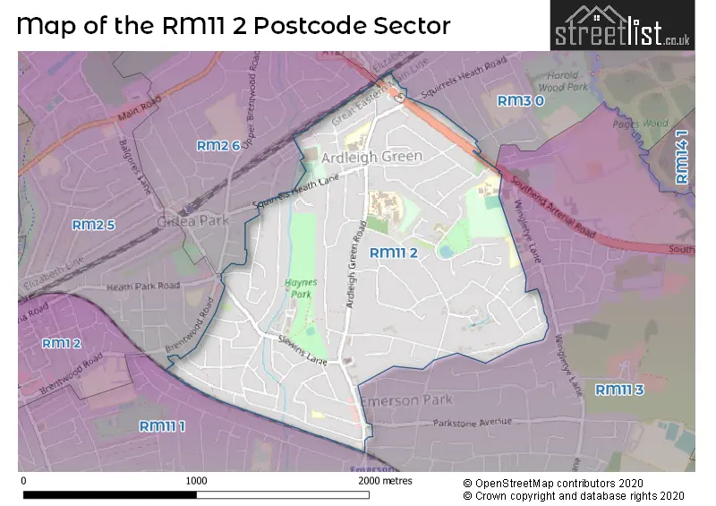
The RM11 2 Postcode shares a border with RM2 5 (ROMFORD , GIDEA PARK ), RM2 6 (ROMFORD , GIDEA PARK , HORNCHURCH ), RM11 3 (HORNCHURCH ), RM3 0 (ROMFORD , HAROLD WOOD ) and RM11 1 (HORNCHURCH ).
The sector is within the post town of HORNCHURCH.
RM11 2 is a postcode sector within the RM11 postcode district which is within the RM Romford postcode area.
The Royal Mail delivery office for the RM11 2 postal sector is the Hornchurch Delivery Office.
The area of the RM11 2 postcode sector is 0.99 square miles which is 2.57 square kilometres or 636.18 square acres.

Map of the RM11 2 Postcode Sector
Explore the RM11 2 postcode sector by using our free interactive map.
| R | M | 1 | 1 | - | 2 | X | X |
| R | M | 1 | 1 | Space | 2 | Letter | Letter |
Official List of Streets
HORNCHURCH (89 Streets)
Unofficial Streets or Alternative Spellings
Gidea Park
SOUTHEND ARTERIAL ROADHORNCHURCH
BERTHER ROAD BURNTWOOD AVENUE TALL PINES CLOSEROMFORD
BRENTWOOD ROAD COOMBE ROAD ELVET AVENUE REDDEN COURT ROAD SQUIRRELS HEATH ROAD THORPE LODGEHORNCHURCH,
SQUIRRELS HEATH LANEWeather Forecast for RM11 2
Press Button to Show Forecast for Romford
| Time Period | Icon | Description | Temperature | Rain Probability | Wind |
|---|---|---|---|---|---|
| 21:00 to 00:00 | Cloudy | 7.0°C (feels like 6.0°C) | 4.00% | NNE 4 mph |
Press Button to Show Forecast for Romford
| Time Period | Icon | Description | Temperature | Rain Probability | Wind |
|---|---|---|---|---|---|
| 00:00 to 03:00 | Cloudy | 6.0°C (feels like 5.0°C) | 5.00% | SE 2 mph | |
| 03:00 to 06:00 | Cloudy | 6.0°C (feels like 4.0°C) | 5.00% | SSW 4 mph | |
| 06:00 to 09:00 | Cloudy | 7.0°C (feels like 5.0°C) | 6.00% | SW 4 mph | |
| 09:00 to 12:00 | Cloudy | 9.0°C (feels like 7.0°C) | 8.00% | W 9 mph | |
| 12:00 to 15:00 | Cloudy | 11.0°C (feels like 8.0°C) | 11.00% | WNW 11 mph | |
| 15:00 to 18:00 | Cloudy | 11.0°C (feels like 9.0°C) | 50.00% | WNW 9 mph | |
| 18:00 to 21:00 | Cloudy | 9.0°C (feels like 7.0°C) | 11.00% | NNW 7 mph | |
| 21:00 to 00:00 | Cloudy | 7.0°C (feels like 5.0°C) | 9.00% | ENE 7 mph |
Press Button to Show Forecast for Romford
| Time Period | Icon | Description | Temperature | Rain Probability | Wind |
|---|---|---|---|---|---|
| 00:00 to 03:00 | Cloudy | 6.0°C (feels like 4.0°C) | 5.00% | NE 7 mph | |
| 03:00 to 06:00 | Cloudy | 5.0°C (feels like 3.0°C) | 5.00% | NE 7 mph | |
| 06:00 to 09:00 | Cloudy | 5.0°C (feels like 2.0°C) | 4.00% | NE 7 mph | |
| 09:00 to 12:00 | Cloudy | 8.0°C (feels like 6.0°C) | 4.00% | ENE 7 mph | |
| 12:00 to 15:00 | Cloudy | 11.0°C (feels like 9.0°C) | 10.00% | E 7 mph | |
| 15:00 to 18:00 | Cloudy | 10.0°C (feels like 9.0°C) | 10.00% | E 7 mph | |
| 18:00 to 21:00 | Cloudy | 9.0°C (feels like 8.0°C) | 10.00% | E 7 mph | |
| 21:00 to 00:00 | Cloudy | 7.0°C (feels like 5.0°C) | 9.00% | E 7 mph |
Press Button to Show Forecast for Romford
| Time Period | Icon | Description | Temperature | Rain Probability | Wind |
|---|---|---|---|---|---|
| 00:00 to 03:00 | Cloudy | 5.0°C (feels like 3.0°C) | 12.00% | ENE 7 mph | |
| 03:00 to 06:00 | Cloudy | 5.0°C (feels like 3.0°C) | 17.00% | NE 7 mph | |
| 06:00 to 09:00 | Light rain | 6.0°C (feels like 4.0°C) | 47.00% | NE 7 mph | |
| 09:00 to 12:00 | Overcast | 10.0°C (feels like 8.0°C) | 20.00% | E 9 mph | |
| 12:00 to 15:00 | Cloudy | 12.0°C (feels like 10.0°C) | 16.00% | E 11 mph | |
| 15:00 to 18:00 | Cloudy | 12.0°C (feels like 10.0°C) | 18.00% | E 11 mph | |
| 18:00 to 21:00 | Light rain | 11.0°C (feels like 9.0°C) | 52.00% | ENE 9 mph | |
| 21:00 to 00:00 | Light rain | 10.0°C (feels like 7.0°C) | 52.00% | ENE 11 mph |
Press Button to Show Forecast for Romford
| Time Period | Icon | Description | Temperature | Rain Probability | Wind |
|---|---|---|---|---|---|
| 00:00 to 03:00 | Heavy rain | 9.0°C (feels like 7.0°C) | 73.00% | ENE 9 mph | |
| 03:00 to 06:00 | Heavy rain shower (night) | 10.0°C (feels like 8.0°C) | 60.00% | ESE 9 mph | |
| 06:00 to 09:00 | Light rain shower (day) | 10.0°C (feels like 8.0°C) | 39.00% | ESE 7 mph | |
| 09:00 to 12:00 | Light rain shower (day) | 11.0°C (feels like 9.0°C) | 40.00% | SE 9 mph | |
| 12:00 to 15:00 | Heavy rain shower (day) | 13.0°C (feels like 11.0°C) | 64.00% | S 11 mph | |
| 15:00 to 18:00 | Light rain shower (day) | 14.0°C (feels like 12.0°C) | 41.00% | SSW 11 mph | |
| 18:00 to 21:00 | Light rain shower (day) | 13.0°C (feels like 11.0°C) | 34.00% | WSW 11 mph | |
| 21:00 to 00:00 | Cloudy | 10.0°C (feels like 9.0°C) | 7.00% | SW 7 mph |
Schools and Places of Education Within the RM11 2 Postcode Sector
Ardleigh Green Junior School
Academy converter
Ardleigh Green Road, Hornchurch, Essex, RM11 2SP
Head: Mrs Janelle Johnson
Ofsted Rating: Outstanding
Inspection: 2023-12-14 (132 days ago)
Website: Visit Ardleigh Green Junior School Website
Phone: 01708443014
Number of Pupils: 361
House Prices in the RM11 2 Postcode Sector
| Type of Property | 2018 Average | 2018 Sales | 2017 Average | 2017 Sales | 2016 Average | 2016 Sales | 2015 Average | 2015 Sales |
|---|---|---|---|---|---|---|---|---|
| Detached | £859,815 | 46 | £885,313 | 58 | £779,902 | 46 | £759,816 | 53 |
| Semi-Detached | £470,026 | 53 | £486,875 | 32 | £428,908 | 38 | £370,013 | 51 |
| Terraced | £432,778 | 36 | £412,450 | 30 | £373,018 | 33 | £349,646 | 45 |
| Flats | £278,228 | 32 | £269,996 | 57 | £260,389 | 39 | £227,033 | 72 |
Important Postcodes RM11 2 in the Postcode Sector
RM11 2LL is the postcode for BLOCK J HAVERING CAMPUS, Havering College of Further & Higher Education, Ardleigh Green Road, BLOCK D HAVERING CAMPUS, Havering College of Further & Higher Education, Ardleigh Green Road, BLOCK B HAVERING CAMPUS, New City College, Ardleigh Green Road, BLOCK W Ardleigh Green Campus, New City College, Ardleigh Green Road, BLOCK W HAVERING CAMPUS, Havering College of Further & Higher Education, Ardleigh Green Road, BLOCK B Ardleigh Green Campus, New City College, Ardleigh Green Road, P BLOCK HAVERING COLLEGE, Havering College of Further & Higher Education, Ardleigh Green Road, BLOCK J Ardleigh Green Campus, New City College, Ardleigh Green Road, BLOCK W HAVERING COLLEGE, Havering College of Further & Higher Education, Ardleigh Green Road, BLOCK W EXTENSION, Havering College of Further & Higher Education, Ardleigh Green Road, BLOCK B HAVERING CAMPUS, Havering College of Further & Higher Education, Ardleigh Green Road, BLOCK E Ardleigh Green Campus, New City College, Ardleigh Green Road, BLOCK A&C Ardleigh Green Campus, New City College, Ardleigh Green Road, BLOCK H HAVERING CAMPUS, Havering College of Further & Higher Education, Ardleigh Green Road, BLOCK H Ardleigh Green Campus, New City College, Ardleigh Green Road, BLOCK A&C HAVERING CAMPUS, Havering College of Further & Higher Education, Ardleigh Green Road, BLOCK A&C HAVERING CAMPUS, New City College, Ardleigh Green Road, and BLOCK E HAVERING CAMPUS, Havering College of Further & Higher Education, Ardleigh Green Road
RM11 2SJ is the postcode for Havering College, Construction Centre, 11-12 Hillman Close, Stafford Industrial Estate
RM11 2SP is the postcode for Ardleigh Green Junior School, Ardleigh Green Road, and Ardleigh Green Infant School, Ardleigh Green Road
| The RM11 2 Sector is within these Local Authorities |
|
|---|---|
| The RM11 2 Sector is within these Counties |
|
| The RM11 2 Sector is within these Water Company Areas |
|