The RM13 postcode district is a postal district located in the RM Romford postcode area with a population of 32,562 residents according to the 2021 England and Wales Census.
The area of the RM13 postcode district is 8.61 square miles which is 22.29 square kilometres or 5,507.57 acres.
Currently, the RM13 district has about 613 postcode units spread across 3 geographic postcode sectors.
Given that each sector allows for 400 unique postcode combinations, the district has a capacity of 1,200 postcodes. With 613 postcodes already in use, this leaves 587 units available.
The RM13 postal code covers the settlement of RAINHAM.
The postcode area has a boundary with Tidal Thames.
The RM13 Postcode shares a border with RM9 (DAGENHAM), RM10 (DAGENHAM), RM15 (SOUTH OCKENDON, AVELEY), RM12 (HORNCHURCH) and RM14 (UPMINSTER, Bulphan, NORTH OCKENDON).
The primary settlement in the RM13 postcode district is Rainham. It is located in the county of Greater London. Wennington is another significant settlement in this postcode district. The primary post town for the RM13 district is Rainham.
For the district RM13, we have data on 4 postcode sectors. Here's a breakdown: The sector RM13 0 is non-geographic. It's often designated for PO Boxes, large organisations, or special services. The sector RM13 7, covers Rainham in Greater London. The sector RM13 8, covers Rainham in Greater London. The sector RM13 9, covers Rainham in Greater London.

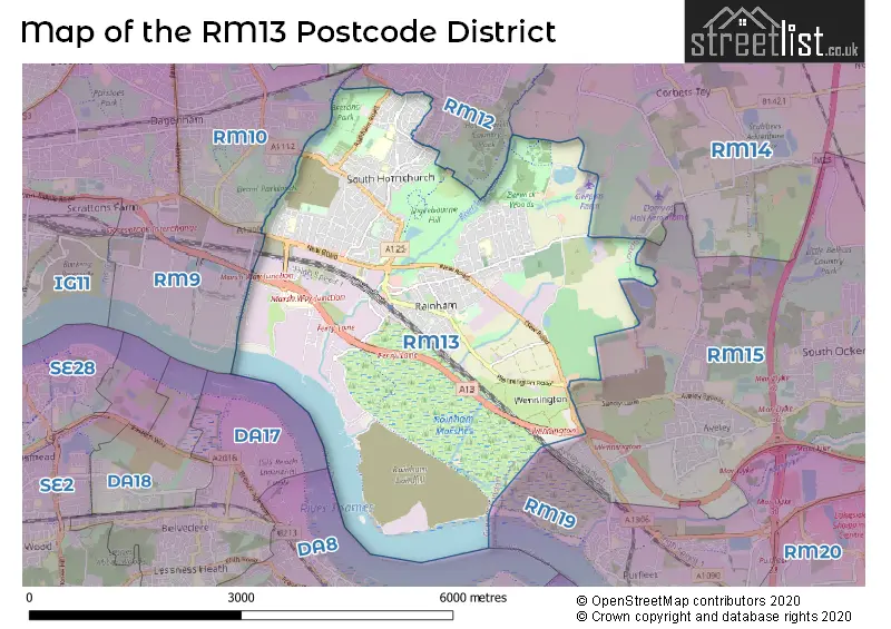
Map of the RM13 Postcode District
Explore the RM13 postcode district by using our free interactive map.
When it comes to local government, postal geography often disregards political borders. However, for a breakdown in the RM13 District: the district mostly encompasses the Havering London Boro area with a total of 649 postcodes.
Recent House Sales in RM13
| Date | Price | Address |
|---|---|---|
| 18/10/2023 | £472,500 | Fairview Avenue, Rainham, RM13 9RP |
| 02/10/2023 | £258,500 | Bader Way, Rainham, RM13 7HU |
| 12/09/2023 | £580,000 | Lovell Walk, Rainham, RM13 7ND |
| 11/09/2023 | £420,000 | Lake Avenue, Rainham, RM13 9SQ |
| 08/09/2023 | £350,000 | Jersey Road, Rainham, RM13 7DR |
| 05/09/2023 | £430,000 | Lakeside, Rainham, RM13 9SW |
| 04/09/2023 | £420,000 | Kingaby Gardens, Rainham, RM13 7PH |
| 31/08/2023 | £395,000 | Louise Gardens, Rainham, RM13 8LH |
| 25/08/2023 | £280,000 | South End Road, Rainham, RM13 7XS |
| 24/08/2023 | £410,000 | Sunningdale Avenue, Rainham, RM13 9NR |
Weather Forecast for RM13
Press Button to Show Forecast for Dagenham
| Time Period | Icon | Description | Temperature | Rain Probability | Wind |
|---|---|---|---|---|---|
| 21:00 to 00:00 | Clear night | 7.0°C (feels like 4.0°C) | 0.00% | N 9 mph |
Press Button to Show Forecast for Dagenham
| Time Period | Icon | Description | Temperature | Rain Probability | Wind |
|---|---|---|---|---|---|
| 00:00 to 03:00 | Clear night | 6.0°C (feels like 3.0°C) | 0.00% | NNW 9 mph | |
| 03:00 to 06:00 | Clear night | 4.0°C (feels like 1.0°C) | 0.00% | NNW 9 mph | |
| 06:00 to 09:00 | Partly cloudy (day) | 5.0°C (feels like 2.0°C) | 0.00% | NNW 9 mph | |
| 09:00 to 12:00 | Cloudy | 8.0°C (feels like 5.0°C) | 3.00% | N 11 mph | |
| 12:00 to 15:00 | Cloudy | 11.0°C (feels like 8.0°C) | 4.00% | N 11 mph | |
| 15:00 to 18:00 | Cloudy | 11.0°C (feels like 9.0°C) | 4.00% | N 11 mph | |
| 18:00 to 21:00 | Cloudy | 10.0°C (feels like 8.0°C) | 4.00% | NNE 9 mph | |
| 21:00 to 00:00 | Partly cloudy (night) | 8.0°C (feels like 6.0°C) | 1.00% | NNE 7 mph |
Press Button to Show Forecast for Dagenham
| Time Period | Icon | Description | Temperature | Rain Probability | Wind |
|---|---|---|---|---|---|
| 00:00 to 03:00 | Partly cloudy (night) | 6.0°C (feels like 4.0°C) | 1.00% | N 4 mph | |
| 03:00 to 06:00 | Cloudy | 5.0°C (feels like 3.0°C) | 4.00% | N 7 mph | |
| 06:00 to 09:00 | Overcast | 5.0°C (feels like 3.0°C) | 9.00% | N 7 mph | |
| 09:00 to 12:00 | Overcast | 8.0°C (feels like 5.0°C) | 9.00% | N 9 mph | |
| 12:00 to 15:00 | Overcast | 10.0°C (feels like 8.0°C) | 10.00% | NNE 11 mph | |
| 15:00 to 18:00 | Cloudy | 11.0°C (feels like 9.0°C) | 7.00% | NNE 11 mph | |
| 18:00 to 21:00 | Cloudy | 10.0°C (feels like 8.0°C) | 7.00% | NNE 9 mph | |
| 21:00 to 00:00 | Clear night | 8.0°C (feels like 5.0°C) | 4.00% | NNE 9 mph |
Press Button to Show Forecast for Dagenham
| Time Period | Icon | Description | Temperature | Rain Probability | Wind |
|---|---|---|---|---|---|
| 00:00 to 03:00 | Partly cloudy (night) | 6.0°C (feels like 4.0°C) | 3.00% | NNE 7 mph | |
| 03:00 to 06:00 | Partly cloudy (night) | 5.0°C (feels like 3.0°C) | 2.00% | N 7 mph | |
| 06:00 to 09:00 | Partly cloudy (day) | 5.0°C (feels like 3.0°C) | 2.00% | N 4 mph | |
| 09:00 to 12:00 | Cloudy | 8.0°C (feels like 7.0°C) | 5.00% | NNE 7 mph | |
| 12:00 to 15:00 | Overcast | 10.0°C (feels like 9.0°C) | 12.00% | N 7 mph | |
| 15:00 to 18:00 | Overcast | 10.0°C (feels like 9.0°C) | 15.00% | NNW 7 mph | |
| 18:00 to 21:00 | Overcast | 9.0°C (feels like 8.0°C) | 17.00% | N 7 mph | |
| 21:00 to 00:00 | Light rain | 8.0°C (feels like 7.0°C) | 46.00% | NNE 4 mph |
Press Button to Show Forecast for Dagenham
| Time Period | Icon | Description | Temperature | Rain Probability | Wind |
|---|---|---|---|---|---|
| 00:00 to 03:00 | Light rain shower (night) | 7.0°C (feels like 5.0°C) | 33.00% | NE 4 mph | |
| 03:00 to 06:00 | Overcast | 6.0°C (feels like 5.0°C) | 18.00% | NNW 4 mph | |
| 06:00 to 09:00 | Overcast | 6.0°C (feels like 5.0°C) | 15.00% | N 4 mph | |
| 09:00 to 12:00 | Cloudy | 8.0°C (feels like 7.0°C) | 12.00% | NNE 7 mph | |
| 12:00 to 15:00 | Overcast | 10.0°C (feels like 9.0°C) | 14.00% | NNE 9 mph | |
| 15:00 to 18:00 | Cloudy | 11.0°C (feels like 9.0°C) | 11.00% | NNE 9 mph | |
| 18:00 to 21:00 | Cloudy | 11.0°C (feels like 9.0°C) | 8.00% | NNE 9 mph | |
| 21:00 to 00:00 | Clear night | 9.0°C (feels like 7.0°C) | 5.00% | NNE 7 mph |
Where is the RM13 Postcode District?
The postcode district RM13 is located in Rainham, which is a town in the London Borough of Havering. Rainham is situated approximately 14.15 miles away from the centre of London. It is surrounded by several nearby towns, including Wennington to the southeast, Elm Park to the north, Aveley to the east, Darent Industrial Park to the south, Erith to the southwest, and Dagenham to the northwest.
The district is within the post town of RAINHAM.
The sector has postcodes within the nation of England.
The RM13 Postcode District is in the Barking & Dagenham and Havering region of Outer London - East and North East within the London.
| Postcode Sector | Delivery Office |
|---|---|
| RM13 7 | Rainham (rm) Delivery Office |
| RM13 8 | Rainham (rm) Delivery Office |
| RM13 9 | Rainham (rm) Delivery Office |
| R | M | 1 | 3 | - | X | X | X |
| R | M | 1 | 3 | Space | Numeric | Letter | Letter |
Tourist Attractions within the Postcode Area
We found 1 visitor attractions within the RM13 postcode area
| Rainham Hall |
|---|
| Historic Properties |
| Historic House / House and Garden / Palace |
| View Rainham Hall on Google Maps |
Current Monthly Rental Prices
| # Bedrooms | Min Price | Max Price | Avg Price |
|---|---|---|---|
| £900 | £900 | £900 | |
| 1 | £900 | £1,400 | £1,160 |
| 2 | £1,200 | £1,950 | £1,513 |
| 3 | £1,750 | £2,250 | £1,917 |
| 4 | £2,400 | £2,400 | £2,400 |
| 5 | £2,400 | £2,400 | £2,400 |
Current House Prices
| # Bedrooms | Min Price | Max Price | Avg Price |
|---|---|---|---|
| 1 | £70,000 | £295,000 | £179,867 |
| 2 | £83,125 | £530,000 | £321,835 |
| 3 | £275,000 | £750,000 | £439,293 |
| 4 | £425,000 | £675,000 | £508,793 |
| 5 | £450,000 | £700,000 | £546,875 |
| 6 | £320,000 | £850,000 | £573,333 |
| 7 | £850,000 | £900,000 | £875,000 |
Estate Agents who Operate in the RM13 District
| Logo | Name | Brand Name | Address | Contact Number | Total Properties |
|---|---|---|---|---|---|
 | Rainham | PATTERSON HAWTHORN | 22 Upminster Road South, Rainham, RM13 9YX | 01708 500000 | 28 |
 | Hornchurch | Balgores | 1 North Street, Hornchurch, RM11 1RL | 01708 204755 | 19 |
 | covering Rainham | haart | covering Rainham | 01700 800114 | 19 |
 | Rainham | William H. Brown Incorporating Porter Glenny | 82 Rainham Road, Rainham, Essex, RM13 7RJ | 01708 207148 | 18 |
 | Rainham | Bairstow Eves | 33 Upminster Road South, Rainham, Essex, RM13 9YS | 01708 973283 | 13 |
| Type of Property | 2018 Average | 2018 Sales | 2017 Average | 2017 Sales | 2016 Average | 2016 Sales | 2015 Average | 2015 Sales |
|---|---|---|---|---|---|---|---|---|
| Detached | £410,486 | 58 | £425,381 | 55 | £413,557 | 61 | £320,102 | 50 |
| Semi-Detached | £355,789 | 133 | £337,537 | 119 | £329,566 | 109 | £290,556 | 125 |
| Terraced | £327,438 | 178 | £319,502 | 177 | £304,110 | 189 | £269,289 | 218 |
| Flats | £213,877 | 57 | £205,440 | 71 | £195,867 | 81 | £162,429 | 79 |