The RM14 postcode district is a postal district located in the RM Romford postcode area with a population of 28,044 residents according to the 2021 England and Wales Census.
The area of the RM14 postcode district is 18.21 square miles which is 47.16 square kilometres or 11,652.58 acres.
Currently, the RM14 district has about 623 postcode units spread across 3 geographic postcode sectors.
Given that each sector allows for 400 unique postcode combinations, the district has a capacity of 1,200 postcodes. With 623 postcodes already in use, this leaves 577 units available.
The largest settlement in the RM14 postal code is UPMINSTER followed by Bulphan, and NORTH OCKENDON.
The RM14 Postcode shares a border with RM13 (RAINHAM), RM16 (GRAYS, CHAFFORD HUNDRED, STIFFORD CLAYS), RM15 (SOUTH OCKENDON, AVELEY), SS17 (STANFORD-LE-HOPE, Corringham, Horndon-on-the-Hill), RM3 (ROMFORD), RM11 (HORNCHURCH), RM12 (HORNCHURCH), SS16 (BASILDON, Langdon Hills, Vange) and CM13 (Hutton, BRENTWOOD, WEST HORNDON).
In the RM14 postcode district, the primary settlement is Upminster, which is located in Greater London. The most significant post town in this district is Upminster, which is also in Greater London. There are also other significant settlements in the district, including Bulphan and North Ockendon, both of which are located in Essex.
For the district RM14, we have data on 4 postcode sectors. Here's a breakdown: The sector RM14 1, covers Upminster in Greater London. The sector RM14 2, covers Upminster in Greater London. The sector RM14 3, covers Upminster in Greater London. The sector RM14 3, covers Bulphan in Essex. The sector RM14 9 is non-geographic. It's often designated for PO Boxes, large organisations, or special services.

Map of the RM14 Postcode District
Explore the RM14 postcode district by using our free interactive map.
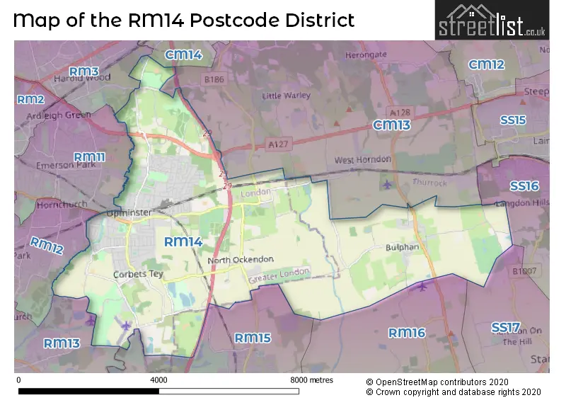
When it comes to local government, postal geography often disregards political borders. However, for a breakdown in the RM14 District: the district mostly encompasses the Havering London Boro (579 postcodes), and finally, the Thurrock (B) area (47 postcodes).
Recent House Sales in RM14
| Date | Price | Address |
|---|---|---|
| 22/09/2023 | £395,000 | Roseberry Gardens, Upminster, RM14 1NF |
| 22/09/2023 | £380,000 | Huskards, Upminster, RM14 1UP |
| 19/09/2023 | £285,000 | Huskards, Upminster, RM14 1UP |
| 12/09/2023 | £480,000 | Church Lane, Bulphan, Upminster, RM14 3TT |
| 01/09/2023 | £425,000 | Front Lane, Upminster, RM14 1LH |
| 31/08/2023 | £455,000 | Clarence Avenue, Upminster, RM14 2RL |
| 31/08/2023 | £523,000 | Derby Avenue, Upminster, RM14 2NS |
| 30/08/2023 | £740,000 | Severn Drive, Upminster, RM14 1QE |
| 25/08/2023 | £500,000 | Corbets Tey Road, Upminster, RM14 2AJ |
| 25/08/2023 | £400,000 | Blyth Walk, Upminster, RM14 1RR |
Weather Forecast for RM14
Press Button to Show Forecast for South Ockendon
| Time Period | Icon | Description | Temperature | Rain Probability | Wind |
|---|---|---|---|---|---|
| 00:00 to 03:00 | Clear night | 5.0°C (feels like 1.0°C) | 0.00% | NNW 9 mph | |
| 03:00 to 06:00 | Partly cloudy (night) | 4.0°C (feels like 0.0°C) | 0.00% | NNW 9 mph | |
| 06:00 to 09:00 | Cloudy | 4.0°C (feels like 1.0°C) | 3.00% | NNW 9 mph | |
| 09:00 to 12:00 | Cloudy | 8.0°C (feels like 5.0°C) | 4.00% | N 13 mph | |
| 12:00 to 15:00 | Cloudy | 10.0°C (feels like 7.0°C) | 4.00% | N 13 mph | |
| 15:00 to 18:00 | Cloudy | 11.0°C (feels like 8.0°C) | 4.00% | N 11 mph | |
| 18:00 to 21:00 | Cloudy | 9.0°C (feels like 7.0°C) | 3.00% | N 11 mph | |
| 21:00 to 00:00 | Clear night | 7.0°C (feels like 5.0°C) | 1.00% | NNE 7 mph |
Press Button to Show Forecast for South Ockendon
| Time Period | Icon | Description | Temperature | Rain Probability | Wind |
|---|---|---|---|---|---|
| 00:00 to 03:00 | Partly cloudy (night) | 5.0°C (feels like 3.0°C) | 1.00% | N 7 mph | |
| 03:00 to 06:00 | Cloudy | 5.0°C (feels like 2.0°C) | 4.00% | NNW 7 mph | |
| 06:00 to 09:00 | Overcast | 5.0°C (feels like 2.0°C) | 9.00% | NNW 7 mph | |
| 09:00 to 12:00 | Overcast | 8.0°C (feels like 5.0°C) | 9.00% | NNE 11 mph | |
| 12:00 to 15:00 | Overcast | 10.0°C (feels like 7.0°C) | 10.00% | NNE 11 mph | |
| 15:00 to 18:00 | Cloudy | 11.0°C (feels like 9.0°C) | 8.00% | NNE 11 mph | |
| 18:00 to 21:00 | Cloudy | 9.0°C (feels like 7.0°C) | 7.00% | NE 9 mph | |
| 21:00 to 00:00 | Clear night | 7.0°C (feels like 4.0°C) | 4.00% | NNE 7 mph |
Press Button to Show Forecast for South Ockendon
| Time Period | Icon | Description | Temperature | Rain Probability | Wind |
|---|---|---|---|---|---|
| 00:00 to 03:00 | Clear night | 5.0°C (feels like 3.0°C) | 2.00% | N 7 mph | |
| 03:00 to 06:00 | Partly cloudy (night) | 4.0°C (feels like 2.0°C) | 1.00% | N 7 mph | |
| 06:00 to 09:00 | Partly cloudy (day) | 5.0°C (feels like 2.0°C) | 1.00% | N 7 mph | |
| 09:00 to 12:00 | Cloudy | 9.0°C (feels like 7.0°C) | 5.00% | NNE 7 mph | |
| 12:00 to 15:00 | Cloudy | 10.0°C (feels like 9.0°C) | 8.00% | N 7 mph | |
| 15:00 to 18:00 | Overcast | 10.0°C (feels like 8.0°C) | 14.00% | NNE 7 mph | |
| 18:00 to 21:00 | Cloudy | 9.0°C (feels like 7.0°C) | 14.00% | NE 7 mph | |
| 21:00 to 00:00 | Light rain | 7.0°C (feels like 6.0°C) | 46.00% | NNE 4 mph |
Press Button to Show Forecast for South Ockendon
| Time Period | Icon | Description | Temperature | Rain Probability | Wind |
|---|---|---|---|---|---|
| 00:00 to 03:00 | Light rain shower (night) | 6.0°C (feels like 4.0°C) | 31.00% | NE 4 mph | |
| 03:00 to 06:00 | Cloudy | 5.0°C (feels like 4.0°C) | 13.00% | NNW 4 mph | |
| 06:00 to 09:00 | Light rain | 6.0°C (feels like 4.0°C) | 41.00% | NNW 4 mph | |
| 09:00 to 12:00 | Cloudy | 8.0°C (feels like 6.0°C) | 12.00% | NNE 9 mph | |
| 12:00 to 15:00 | Overcast | 10.0°C (feels like 8.0°C) | 13.00% | NNE 9 mph | |
| 15:00 to 18:00 | Overcast | 11.0°C (feels like 9.0°C) | 13.00% | NNE 9 mph | |
| 18:00 to 21:00 | Cloudy | 10.0°C (feels like 8.0°C) | 8.00% | NNE 9 mph | |
| 21:00 to 00:00 | Clear night | 8.0°C (feels like 6.0°C) | 5.00% | NNE 7 mph |
Where is the RM14 Postcode District?
The RM14 postcode district is located in the town of Upminster. It is situated near several towns, including North Ockendon to the southeast, Little Warley to the north, South Ockendon to the south, Bulphan to the east, West Horndon to the northeast, and Emerson Park to the northwest. The postcode district is approximately 18.6 miles away from the center of London.
The district is within the post town of UPMINSTER.
The sector has postcodes within the nation of England.
The RM14 Postcode District is covers the following regions.
- Barking & Dagenham and Havering - Outer London - East and North East - London
- Thurrock - Essex - East of England
| Postcode Sector | Delivery Office |
|---|---|
| RM14 1 | Upminster Delivery Office |
| RM14 2 | Upminster Delivery Office |
| RM14 3 | Upminster Delivery Office |
| R | M | 1 | 4 | - | X | X | X |
| R | M | 1 | 4 | Space | Numeric | Letter | Letter |
Tourist Attractions within the Postcode Area
We found 1 visitor attractions within the RM14 postcode area
| Thames Chase Forest Centre |
|---|
| Country Parks |
| Country Park |
| View Thames Chase Forest Centre on Google Maps |
Current Monthly Rental Prices
| # Bedrooms | Min Price | Max Price | Avg Price |
|---|---|---|---|
| £2,688 | £2,688 | £2,688 | |
| 1 | £1,100 | £1,100 | £1,100 |
| 2 | £1,450 | £1,450 | £1,450 |
| 3 | £2,650 | £2,650 | £2,650 |
| 4 | £3,000 | £4,500 | £3,750 |
| 5 | £4,000 | £4,000 | £4,000 |
Current House Prices
| # Bedrooms | Min Price | Max Price | Avg Price |
|---|---|---|---|
| 1 | £170,000 | £450,000 | £253,333 |
| 2 | £240,000 | £675,000 | £425,907 |
| 3 | £300,000 | £3,000,000 | £656,645 |
| 4 | £275,000 | £1,350,000 | £781,517 |
| 5 | £600,000 | £2,000,000 | £1,002,188 |
| 6 | £875,000 | £4,495,000 | £2,124,000 |
| 11 | £1,450,000 | £1,450,000 | £1,450,000 |
Estate Agents who Operate in the RM14 District
| Logo | Name | Brand Name | Address | Contact Number | Total Properties |
|---|---|---|---|---|---|
 | Upminster | Mark Bowyer Estate Agents | 17 Corbets Tey Road, Upminster, RM14 2AP | 01708 204985 | 35 |
 | at Upminster | Beresfords | 16 Station Road, Upminster, RM14 2UB | 01708 209955 | 34 |
 | Upminster | Balgores | 63 Station Road, Upminster, RM14 2SU | 01708 204921 | 31 |
 | UPMINSTER | Gates Parish & Co | 32 Station Road, Upminster, RM14 2TX | 01708 250033 | 24 |
 | Upminster | Griffin Residential Group | 12 Station Road, Upminster, RM14 2UB | 01751 200591 | 8 |
| Type of Property | 2018 Average | 2018 Sales | 2017 Average | 2017 Sales | 2016 Average | 2016 Sales | 2015 Average | 2015 Sales |
|---|---|---|---|---|---|---|---|---|
| Detached | £739,580 | 56 | £715,802 | 69 | £699,901 | 59 | £632,026 | 76 |
| Semi-Detached | £548,732 | 199 | £526,627 | 188 | £520,698 | 186 | £455,231 | 211 |
| Terraced | £439,790 | 74 | £438,491 | 54 | £397,095 | 48 | £347,090 | 61 |
| Flats | £306,544 | 62 | £318,999 | 68 | £315,326 | 67 | £249,224 | 68 |