The RM2 6 postcode sector is within the county of Greater London.
Did you know? According to the 2021 Census, the RM2 6 postcode sector is home to a bustling 6,798 residents!
Given that each sector allows for 400 unique postcode combinations. Letters C, I, K, M, O and V are not allowed in the last two letters of a postcode. With 126 postcodes already in use, this leaves 274 units available.
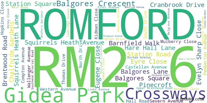
The largest settlement in the RM2 6 postal code is ROMFORD followed by GIDEA PARK , and HORNCHURCH .
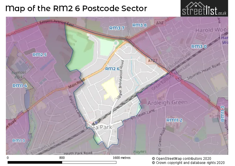
The RM2 6 Postcode shares a border with RM2 5 (ROMFORD , GIDEA PARK ), RM3 8 (ROMFORD , HAROLD HILL ), RM11 2 (HORNCHURCH ), RM3 0 (ROMFORD , HAROLD WOOD ) and RM3 7 (ROMFORD , NOAK HILL ).
The sector is within the post town of ROMFORD.
RM2 6 is a postcode sector within the RM2 postcode district which is within the RM Romford postcode area.
The Royal Mail delivery office for the RM2 6 postal sector is the Romford Delivery Office.
The area of the RM2 6 postcode sector is 0.57 square miles which is 1.48 square kilometres or 365.66 square acres.

Map of the RM2 6 Postcode Sector
Explore the RM2 6 postcode sector by using our free interactive map.
| R | M | 2 | - | 6 | X | X |
| R | M | 2 | Space | 6 | Letter | Letter |
Official List of Streets
ROMFORD (49 Streets)
Unofficial Streets or Alternative Spellings
Weather Forecast for RM2 6
Press Button to Show Forecast for Romford
| Time Period | Icon | Description | Temperature | Rain Probability | Wind |
|---|---|---|---|---|---|
| 18:00 to 21:00 | Cloudy | 9.0°C (feels like 7.0°C) | 5.00% | N 11 mph | |
| 21:00 to 00:00 | Cloudy | 7.0°C (feels like 5.0°C) | 4.00% | N 7 mph |
Press Button to Show Forecast for Romford
| Time Period | Icon | Description | Temperature | Rain Probability | Wind |
|---|---|---|---|---|---|
| 00:00 to 03:00 | Clear night | 6.0°C (feels like 3.0°C) | 0.00% | NW 7 mph | |
| 03:00 to 06:00 | Clear night | 4.0°C (feels like 1.0°C) | 0.00% | NNW 9 mph | |
| 06:00 to 09:00 | Partly cloudy (day) | 4.0°C (feels like 1.0°C) | 1.00% | NNW 9 mph | |
| 09:00 to 12:00 | Cloudy | 8.0°C (feels like 5.0°C) | 4.00% | NNW 13 mph | |
| 12:00 to 15:00 | Cloudy | 10.0°C (feels like 8.0°C) | 4.00% | NNW 13 mph | |
| 15:00 to 18:00 | Cloudy | 11.0°C (feels like 8.0°C) | 5.00% | NNW 11 mph | |
| 18:00 to 21:00 | Cloudy | 9.0°C (feels like 7.0°C) | 4.00% | N 9 mph | |
| 21:00 to 00:00 | Clear night | 7.0°C (feels like 5.0°C) | 1.00% | NE 4 mph |
Press Button to Show Forecast for Romford
| Time Period | Icon | Description | Temperature | Rain Probability | Wind |
|---|---|---|---|---|---|
| 00:00 to 03:00 | Cloudy | 5.0°C (feels like 4.0°C) | 4.00% | WSW 4 mph | |
| 03:00 to 06:00 | Cloudy | 5.0°C (feels like 3.0°C) | 4.00% | WSW 4 mph | |
| 06:00 to 09:00 | Cloudy | 6.0°C (feels like 4.0°C) | 5.00% | WSW 7 mph | |
| 09:00 to 12:00 | Cloudy | 9.0°C (feels like 7.0°C) | 7.00% | W 9 mph | |
| 12:00 to 15:00 | Cloudy | 11.0°C (feels like 9.0°C) | 9.00% | WNW 9 mph | |
| 15:00 to 18:00 | Overcast | 12.0°C (feels like 10.0°C) | 14.00% | WNW 9 mph | |
| 18:00 to 21:00 | Overcast | 10.0°C (feels like 9.0°C) | 14.00% | NW 7 mph | |
| 21:00 to 00:00 | Cloudy | 8.0°C (feels like 6.0°C) | 7.00% | NNE 4 mph |
Press Button to Show Forecast for Romford
| Time Period | Icon | Description | Temperature | Rain Probability | Wind |
|---|---|---|---|---|---|
| 00:00 to 03:00 | Cloudy | 6.0°C (feels like 5.0°C) | 4.00% | NE 4 mph | |
| 03:00 to 06:00 | Cloudy | 5.0°C (feels like 4.0°C) | 5.00% | NE 4 mph | |
| 06:00 to 09:00 | Cloudy | 6.0°C (feels like 4.0°C) | 7.00% | ENE 4 mph | |
| 09:00 to 12:00 | Cloudy | 9.0°C (feels like 7.0°C) | 7.00% | E 7 mph | |
| 12:00 to 15:00 | Overcast | 11.0°C (feels like 9.0°C) | 13.00% | SE 9 mph | |
| 15:00 to 18:00 | Cloudy | 11.0°C (feels like 9.0°C) | 12.00% | SE 9 mph | |
| 18:00 to 21:00 | Cloudy | 10.0°C (feels like 8.0°C) | 11.00% | ESE 9 mph | |
| 21:00 to 00:00 | Cloudy | 8.0°C (feels like 6.0°C) | 10.00% | ESE 7 mph |
Press Button to Show Forecast for Romford
| Time Period | Icon | Description | Temperature | Rain Probability | Wind |
|---|---|---|---|---|---|
| 00:00 to 03:00 | Overcast | 8.0°C (feels like 6.0°C) | 17.00% | ESE 7 mph | |
| 03:00 to 06:00 | Cloudy | 7.0°C (feels like 6.0°C) | 15.00% | E 7 mph | |
| 06:00 to 09:00 | Overcast | 8.0°C (feels like 6.0°C) | 16.00% | E 7 mph | |
| 09:00 to 12:00 | Cloudy | 11.0°C (feels like 9.0°C) | 12.00% | SE 9 mph | |
| 12:00 to 15:00 | Light rain | 13.0°C (feels like 11.0°C) | 40.00% | ESE 9 mph | |
| 15:00 to 18:00 | Light rain shower (day) | 13.0°C (feels like 11.0°C) | 32.00% | ESE 9 mph | |
| 18:00 to 21:00 | Cloudy | 12.0°C (feels like 11.0°C) | 14.00% | ENE 9 mph | |
| 21:00 to 00:00 | Cloudy | 11.0°C (feels like 9.0°C) | 12.00% | ENE 7 mph |
Schools and Places of Education Within the RM2 6 Postcode Sector
The Royal Liberty School
Academy converter
Upper Brentwood Road, Romford, Essex, RM2 6HJ
Head: Mr Lee Raftery
Ofsted Rating: Good
Inspection: 2019-02-05 (1904 days ago)
Website: Visit The Royal Liberty School Website
Phone: 01708730141
Number of Pupils: 736
House Prices in the RM2 6 Postcode Sector
| Type of Property | 2018 Average | 2018 Sales | 2017 Average | 2017 Sales | 2016 Average | 2016 Sales | 2015 Average | 2015 Sales |
|---|---|---|---|---|---|---|---|---|
| Detached | £903,556 | 9 | £772,778 | 9 | £802,857 | 14 | £657,346 | 26 |
| Semi-Detached | £519,043 | 22 | £491,038 | 39 | £436,734 | 35 | £451,716 | 38 |
| Terraced | £394,810 | 21 | £421,559 | 17 | £433,697 | 15 | £353,531 | 16 |
| Flats | £267,780 | 44 | £271,146 | 59 | £243,711 | 58 | £216,066 | 54 |
Important Postcodes RM2 6 in the Postcode Sector
RM2 6HJ is the postcode for Creative Arts Building, Royal Liberty School, Upper Brentwood Road, New Sports Building, Royal Liberty School, Upper Brentwood Road, Humanities Building, Royal Liberty School, Upper Brentwood Road, MAIN BUILDING, Royal Liberty School, Upper Brentwood Road, Royal Liberty School, Upper Brentwood Road, CDT Building, Royal Liberty School, Upper Brentwood Road, and Old Sports Building, Royal Liberty School, Upper Brentwood Road
| The RM2 6 Sector is within these Local Authorities |
|
|---|---|
| The RM2 6 Sector is within these Counties |
|
| The RM2 6 Sector is within these Water Company Areas |
|