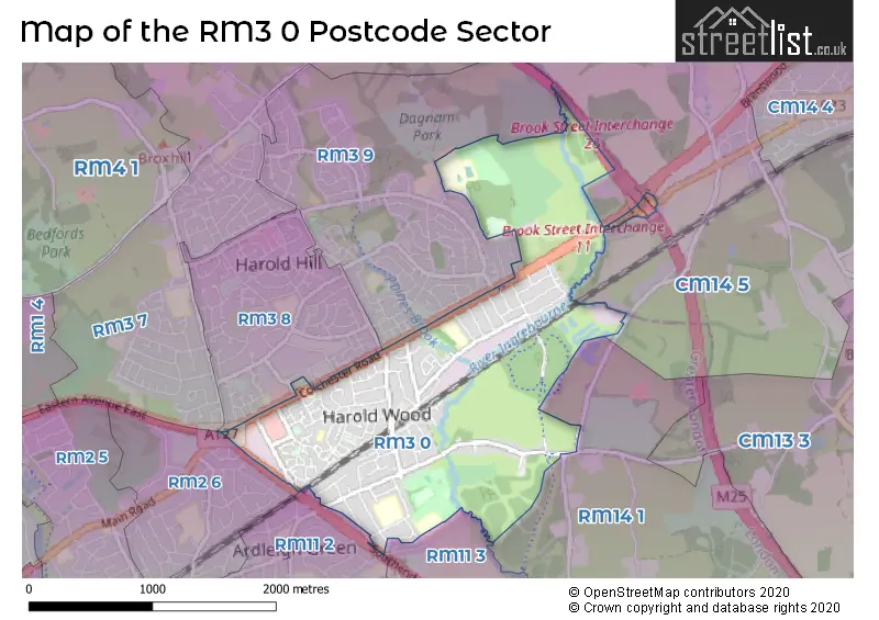
The RM3 0 postcode sector stands on the Essex and Greater London border.
Did you know? According to the 2021 Census, the RM3 0 postcode sector is home to a bustling 12,282 residents!
Given that each sector allows for 400 unique postcode combinations. Letters C, I, K, M, O and V are not allowed in the last two letters of a postcode. With 252 postcodes already in use, this leaves 148 units available.
The largest settlements in the RM3 0 postal code are ROMFORD and HAROLD WOOD .
The RM3 0 Postcode shares a border with RM2 6 (ROMFORD , GIDEA PARK , HORNCHURCH ), RM3 8 (ROMFORD , HAROLD HILL ), RM3 9 (ROMFORD ), RM11 2 (HORNCHURCH ), RM11 3 (HORNCHURCH ), CM14 5 (Warley, BRENTWOOD, Pilgrims Hatch) and RM14 1 (UPMINSTER).
The sector is within the post town of ROMFORD.
RM3 0 is a postcode sector within the RM3 postcode district which is within the RM Romford postcode area.
The Royal Mail delivery office for the RM3 0 postal sector is the Harold Hill Delivery Office.
The area of the RM3 0 postcode sector is 1.90 square miles which is 4.93 square kilometres or 1,218.45 square acres.
The RM3 0 postcode sector is crossed by the A1023 Major A road.
The RM3 0 postcode sector is crossed by the A12 Major A road.
The RM3 0 postcode sector is crossed by the M25 motorway.
Waterways within the RM3 0 postcode sector include the Paines Brook, River Ingrebourne.

Map of the RM3 0 Postcode Sector
Explore the RM3 0 postcode sector by using our free interactive map.
| R | M | 3 | - | 0 | X | X |
| R | M | 3 | Space | 0 | Letter | Letter |
Official List of Streets
ROMFORD (104 Streets)
Harold Wood (31 Streets)
Unofficial Streets or Alternative Spellings
Gidea Park
SOUTHEND ARTERIAL ROADROMFORD
GOOSHAYS DRIVE KENILWORTH AVENUE MAIN ROAD OAKLEY DRIVE PETERSFIELD AVENUE SETTLE ROAD SHEFFIELD DRIVE SHEFFIELD GARDENS WOODSTOCK AVENUE ASH FLOWER DRIVE AUBRETIA CLOSE BIBI PLACE BROOK STREET ROUNDABOUT CHARLOCK CL GALLOWS CORNER GALLOWS CORNER FLYOVER HAR IVY LODGE LANE LISTER AVENUE MAWBERRY GROVE NAGS HEAD LANE POYNINGS WAY PUTWELL BRIDGE ST ETHELBURGA COURT WATERSIDE CLOSEGreat Warley
WARLEY ROADHarold Hill
TANGENT LINKBRENTWOOD
BROOK STREETWeather Forecast for RM3 0
Press Button to Show Forecast for Brentwood Leisure Park
| Time Period | Icon | Description | Temperature | Rain Probability | Wind |
|---|---|---|---|---|---|
| 18:00 to 21:00 | Cloudy | 8.0°C (feels like 6.0°C) | 12.00% | N 7 mph | |
| 21:00 to 00:00 | Cloudy | 6.0°C (feels like 5.0°C) | 9.00% | ENE 4 mph |
Press Button to Show Forecast for Brentwood Leisure Park
| Time Period | Icon | Description | Temperature | Rain Probability | Wind |
|---|---|---|---|---|---|
| 00:00 to 03:00 | Cloudy | 5.0°C (feels like 3.0°C) | 4.00% | NE 4 mph | |
| 03:00 to 06:00 | Cloudy | 4.0°C (feels like 2.0°C) | 5.00% | NE 4 mph | |
| 06:00 to 09:00 | Cloudy | 4.0°C (feels like 2.0°C) | 4.00% | NE 4 mph | |
| 09:00 to 12:00 | Cloudy | 7.0°C (feels like 5.0°C) | 4.00% | ENE 7 mph | |
| 12:00 to 15:00 | Overcast | 9.0°C (feels like 7.0°C) | 9.00% | E 7 mph | |
| 15:00 to 18:00 | Overcast | 9.0°C (feels like 7.0°C) | 13.00% | E 9 mph | |
| 18:00 to 21:00 | Cloudy | 8.0°C (feels like 6.0°C) | 10.00% | E 9 mph | |
| 21:00 to 00:00 | Cloudy | 6.0°C (feels like 4.0°C) | 10.00% | E 7 mph |
Press Button to Show Forecast for Brentwood Leisure Park
| Time Period | Icon | Description | Temperature | Rain Probability | Wind |
|---|---|---|---|---|---|
| 00:00 to 03:00 | Overcast | 6.0°C (feels like 4.0°C) | 16.00% | ENE 7 mph | |
| 03:00 to 06:00 | Light rain | 6.0°C (feels like 3.0°C) | 45.00% | ENE 7 mph | |
| 06:00 to 09:00 | Cloudy | 6.0°C (feels like 4.0°C) | 20.00% | ENE 9 mph | |
| 09:00 to 12:00 | Cloudy | 9.0°C (feels like 7.0°C) | 20.00% | E 9 mph | |
| 12:00 to 15:00 | Cloudy | 11.0°C (feels like 9.0°C) | 16.00% | E 11 mph | |
| 15:00 to 18:00 | Cloudy | 12.0°C (feels like 10.0°C) | 19.00% | E 11 mph | |
| 18:00 to 21:00 | Light rain | 11.0°C (feels like 9.0°C) | 49.00% | E 9 mph | |
| 21:00 to 00:00 | Light rain | 9.0°C (feels like 7.0°C) | 50.00% | ENE 9 mph |
Press Button to Show Forecast for Brentwood Leisure Park
| Time Period | Icon | Description | Temperature | Rain Probability | Wind |
|---|---|---|---|---|---|
| 00:00 to 03:00 | Light rain | 9.0°C (feels like 7.0°C) | 53.00% | E 9 mph | |
| 03:00 to 06:00 | Light rain shower (night) | 9.0°C (feels like 7.0°C) | 43.00% | ESE 9 mph | |
| 06:00 to 09:00 | Light rain | 9.0°C (feels like 7.0°C) | 51.00% | SE 9 mph | |
| 09:00 to 12:00 | Heavy rain shower (day) | 11.0°C (feels like 8.0°C) | 58.00% | S 11 mph | |
| 12:00 to 15:00 | Heavy rain shower (day) | 12.0°C (feels like 10.0°C) | 61.00% | S 11 mph | |
| 15:00 to 18:00 | Heavy rain shower (day) | 13.0°C (feels like 11.0°C) | 55.00% | SSW 11 mph | |
| 18:00 to 21:00 | Light rain shower (day) | 12.0°C (feels like 10.0°C) | 35.00% | SSW 9 mph | |
| 21:00 to 00:00 | Partly cloudy (night) | 10.0°C (feels like 8.0°C) | 4.00% | SSW 7 mph |
Schools and Places of Education Within the RM3 0 Postcode Sector
Harold Court Primary School
Community school
Church Road, Romford, Essex, RM3 0SH
Head: Mrs Lynn Hogan O'Neill
Ofsted Rating: Good
Inspection: 2022-11-30 (512 days ago)
Website: Visit Harold Court Primary School Website
Phone: 01708342275
Number of Pupils: 384
Harold Wood Primary School
Community school
Recreation Avenue, Romford, Essex, RM3 0TH
Head: Mr Stuart Fryd
Ofsted Rating: Good
Inspection: 2019-02-28 (1883 days ago)
Website: Visit Harold Wood Primary School Website
Phone: 01708345473
Number of Pupils: 622
Redden Court School
Academy converter
Cotswold Road, Romford, Essex, RM3 0TS
Head: Mr Anthony Henry
Ofsted Rating: Outstanding
Inspection: 2022-10-19 (554 days ago)
Website: Visit Redden Court School Website
Phone: 01708342293
Number of Pupils: 1019
House Prices in the RM3 0 Postcode Sector
| Type of Property | 2018 Average | 2018 Sales | 2017 Average | 2017 Sales | 2016 Average | 2016 Sales | 2015 Average | 2015 Sales |
|---|---|---|---|---|---|---|---|---|
| Detached | £529,882 | 17 | £532,975 | 20 | £492,062 | 16 | £481,056 | 26 |
| Semi-Detached | £436,134 | 73 | £401,163 | 66 | £414,247 | 84 | £375,893 | 101 |
| Terraced | £359,377 | 53 | £409,060 | 66 | £442,398 | 69 | £310,802 | 48 |
| Flats | £336,934 | 206 | £318,309 | 156 | £298,466 | 104 | £209,447 | 106 |
Important Postcodes RM3 0 in the Postcode Sector
RM3 0AR is the postcode for Long Term Conditions Centre, Harold Wood Hospital, Gubbins Lane, LONG TERM CONDITIONS CENTRE, Long Term Conditions Centre, Harold Wood Hospital, Gubbins Lane, and Harold Wood Polyclinic, Harold Wood Hospital, Gubbins Lane
RM3 0BE is the postcode for LSBU at Havering, London South Bank University, London South Bank University, Goldcrest Way, and LONDON SOUTH BANK UNIVERSITY, GOLDCREST WAY, ROMFORD
RM3 0FE is the postcode for Harold Wood Polyclinic, Gubbins Lane
RM3 0QA is the postcode for Gubbins Lane Community Services, 26 Gubbins Lane, Harold Wood, and Harold Wood Clinic, 24 Gubbins Lane
RM3 0SH is the postcode for Harold Court Primary School, Church Road, Harold Wood, Mental Health Initial Assessment Team, 137-145 Church Road, Harold Wood, and MAIN BUILDING, Harold Court School, Harold Wood, Church Road
RM3 0TH is the postcode for MAIN BUILDING, Harold Wood Primary School, Recreation Avenue, INFANT BLOCK B, Harold Wood Primary School, Recreation Avenue, and JUNIOR BLOCK A, Harold Wood Primary School, Recreation Avenue
RM3 0TS is the postcode for PSYCHOMETRIC BLOCK, Redden Court School, Cotswold Road, BLOCK B, Redden Court School, Cotswold Road, SPORTS BLOCK, Redden Court School, Cotswold Road, MAIN BUILDING, Redden Court School, Cotswold Road, SCIENCE BLOCK, Redden Court School, Cotswold Road, ACTIVITY BLOCK, Redden Court School, Cotswold Road, and LIBRARY BLOCK, Redden Court School, Cotswold Road
| The RM3 0 Sector is within these Local Authorities |
|
|---|---|
| The RM3 0 Sector is within these Counties |
|
| The RM3 0 Sector is within these Water Company Areas |
|