The RM5 postcode district is a postal district located in the RM Romford postcode area with a population of 20,835 residents according to the 2021 England and Wales Census.
The area of the RM5 postcode district is 2.80 square miles which is 7.25 square kilometres or 1,790.56 acres.
Currently, the RM5 district has about 376 postcode units spread across 2 geographic postcode sectors.
Given that each sector allows for 400 unique postcode combinations, the district has a capacity of 800 postcodes. With 376 postcodes already in use, this leaves 424 units available.
The RM5 postal code covers the settlement of ROMFORD.
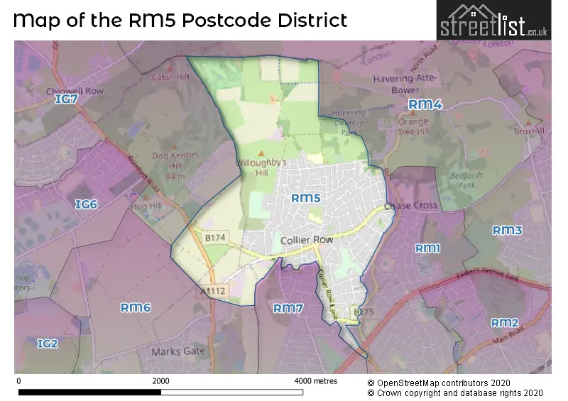
The RM5 Postcode shares a border with RM7 (ROMFORD, RUSH GREEN), RM1 (ROMFORD) and RM4 (LAMBOURNE, STAPLEFORD ABBOTTS, HAVERING-ATTE-BOWER).
The primary settlement in the RM5 postcode district is Romford in the county of Greater London. There is also a significant secondary settlement called Collier Row. The post town for both settlements is Romford.
For the district RM5, we have data on 2 postcode sectors. Here's a breakdown: The sector RM5 2, covers Romford in Greater London. The sector RM5 3, covers Romford in Greater London.


Map of the RM5 Postcode District
Explore the RM5 postcode district by using our free interactive map.
When it comes to local government, postal geography often disregards political borders. However, for a breakdown in the RM5 District: the district mostly encompasses the Havering London Boro (368 postcodes), and finally, the Barking and Dagenham London Boro area (9 postcodes).
Recent House Sales in RM5
| Date | Price | Address |
|---|---|---|
| 16/10/2023 | £410,000 | Hamlet Road, Romford, RM5 2DS |
| 06/10/2023 | £310,000 | Udall Gardens, Romford, RM5 2LA |
| 08/09/2023 | £400,000 | Highfield Road, Romford, RM5 3AW |
| 01/09/2023 | £277,500 | Erith Crescent, Romford, RM5 3JJ |
| 30/08/2023 | £330,000 | Larchwood Close, Collier Row, Romford, RM5 3QX |
| 30/08/2023 | £461,000 | Larchwood Avenue, Romford, RM5 2QL |
| 29/08/2023 | £660,000 | Lawns Way, Romford, RM5 3TH |
| 25/08/2023 | £535,000 | Oaks Avenue, Romford, RM5 3BS |
| 25/08/2023 | £515,000 | Lynwood Drive, Romford, RM5 2QX |
| 25/08/2023 | £210,000 | Horndon Road, Collier Row, Romford, RM5 3HB |
Weather Forecast for RM5
Press Button to Show Forecast for Romford
| Time Period | Icon | Description | Temperature | Rain Probability | Wind |
|---|---|---|---|---|---|
| 09:00 to 12:00 | Cloudy | 8.0°C (feels like 5.0°C) | 4.00% | NNW 13 mph | |
| 12:00 to 15:00 | Cloudy | 10.0°C (feels like 8.0°C) | 4.00% | NNW 13 mph | |
| 15:00 to 18:00 | Cloudy | 11.0°C (feels like 8.0°C) | 5.00% | NNW 11 mph | |
| 18:00 to 21:00 | Cloudy | 9.0°C (feels like 7.0°C) | 4.00% | N 9 mph | |
| 21:00 to 00:00 | Clear night | 7.0°C (feels like 5.0°C) | 1.00% | NE 4 mph |
Press Button to Show Forecast for Romford
| Time Period | Icon | Description | Temperature | Rain Probability | Wind |
|---|---|---|---|---|---|
| 00:00 to 03:00 | Cloudy | 5.0°C (feels like 4.0°C) | 4.00% | WSW 4 mph | |
| 03:00 to 06:00 | Cloudy | 5.0°C (feels like 3.0°C) | 4.00% | WSW 4 mph | |
| 06:00 to 09:00 | Cloudy | 6.0°C (feels like 4.0°C) | 5.00% | WSW 7 mph | |
| 09:00 to 12:00 | Cloudy | 9.0°C (feels like 7.0°C) | 7.00% | W 9 mph | |
| 12:00 to 15:00 | Cloudy | 11.0°C (feels like 9.0°C) | 9.00% | WNW 9 mph | |
| 15:00 to 18:00 | Overcast | 12.0°C (feels like 10.0°C) | 14.00% | WNW 9 mph | |
| 18:00 to 21:00 | Overcast | 10.0°C (feels like 9.0°C) | 14.00% | NW 7 mph | |
| 21:00 to 00:00 | Cloudy | 8.0°C (feels like 6.0°C) | 7.00% | NNE 4 mph |
Press Button to Show Forecast for Romford
| Time Period | Icon | Description | Temperature | Rain Probability | Wind |
|---|---|---|---|---|---|
| 00:00 to 03:00 | Cloudy | 6.0°C (feels like 5.0°C) | 4.00% | NE 4 mph | |
| 03:00 to 06:00 | Cloudy | 5.0°C (feels like 4.0°C) | 5.00% | NE 4 mph | |
| 06:00 to 09:00 | Cloudy | 6.0°C (feels like 4.0°C) | 7.00% | ENE 4 mph | |
| 09:00 to 12:00 | Cloudy | 9.0°C (feels like 7.0°C) | 7.00% | E 7 mph | |
| 12:00 to 15:00 | Overcast | 11.0°C (feels like 9.0°C) | 13.00% | SE 9 mph | |
| 15:00 to 18:00 | Cloudy | 11.0°C (feels like 9.0°C) | 12.00% | SE 9 mph | |
| 18:00 to 21:00 | Cloudy | 10.0°C (feels like 8.0°C) | 11.00% | ESE 9 mph | |
| 21:00 to 00:00 | Cloudy | 8.0°C (feels like 6.0°C) | 10.00% | ESE 7 mph |
Press Button to Show Forecast for Romford
| Time Period | Icon | Description | Temperature | Rain Probability | Wind |
|---|---|---|---|---|---|
| 00:00 to 03:00 | Overcast | 8.0°C (feels like 6.0°C) | 17.00% | ESE 7 mph | |
| 03:00 to 06:00 | Cloudy | 7.0°C (feels like 6.0°C) | 15.00% | E 7 mph | |
| 06:00 to 09:00 | Overcast | 8.0°C (feels like 6.0°C) | 16.00% | E 7 mph | |
| 09:00 to 12:00 | Cloudy | 11.0°C (feels like 9.0°C) | 12.00% | SE 9 mph | |
| 12:00 to 15:00 | Light rain | 13.0°C (feels like 11.0°C) | 40.00% | ESE 9 mph | |
| 15:00 to 18:00 | Light rain shower (day) | 13.0°C (feels like 11.0°C) | 32.00% | ESE 9 mph | |
| 18:00 to 21:00 | Cloudy | 12.0°C (feels like 11.0°C) | 14.00% | ENE 9 mph | |
| 21:00 to 00:00 | Cloudy | 11.0°C (feels like 9.0°C) | 12.00% | ENE 7 mph |
Where is the RM5 Postcode District?
The postcode district RM5 is located in Romford, which is a district town. It is situated near several nearby towns: Collier Row to the South East (0.37 miles away), Havering-atte-Bower to the North East (1.36 miles away), Mawneys to the South (1.72 miles away), Stapleford Abbotts to the North (2.38 miles away), Hainault to the West (2.47 miles away), Chadwell Heath to the South West (2.64 miles away), and Lambourne to the North West (2.78 miles away). Additionally, Romford is approximately 14.06 miles away from the center of London.
The district is within the post town of ROMFORD.
The sector has postcodes within the nation of England.
The RM5 Postcode District is in the Barking & Dagenham and Havering region of Outer London - East and North East within the London.
| Postcode Sector | Delivery Office |
|---|---|
| RM5 2 | Romford Delivery Office |
| RM5 3 | Romford Delivery Office |
| R | M | 5 | - | X | X | X |
| R | M | 5 | Space | Numeric | Letter | Letter |
Current Monthly Rental Prices
| # Bedrooms | Min Price | Max Price | Avg Price |
|---|---|---|---|
| £866 | £1,250 | £1,058 | |
| 1 | £550 | £1,400 | £850 |
| 2 | £1,400 | £1,400 | £1,400 |
| 3 | £1,750 | £2,200 | £1,988 |
| 4 | £2,500 | £2,500 | £2,500 |
Current House Prices
| # Bedrooms | Min Price | Max Price | Avg Price |
|---|---|---|---|
| £27,500 | £70,000 | £43,167 | |
| 2 | £250,000 | £475,000 | £359,500 |
| 3 | £300,000 | £625,000 | £441,981 |
| 4 | £425,000 | £700,000 | £515,333 |
| 5 | £575,000 | £800,000 | £703,333 |
| 6 | £530,000 | £530,000 | £530,000 |
| 7 | £1,100,000 | £1,100,000 | £1,100,000 |
Estate Agents who Operate in the RM5 District
| Logo | Name | Brand Name | Address | Contact Number | Total Properties |
|---|---|---|---|---|---|
 | Collier Row | Bairstow Eves | 20 Collier Row Road, Collier Row, Romford, Essex, RM5 3NX | 01708 202356 | 21 |
 | Collier Row | Keystones Property | 13 Clockhouse Lane, Collier Row, Romford, RM5 3PH | 07446 942901 | 16 |
 | covering Romford | Purplebricks | Suite 7 First Floor Cranmore Drive Shirley Solihull B90 4RZ | 020 3910 6289 | 9 |
 | at Gidea Park | Beresfords | 85 Main Road, Gidea Park, Romford, RM2 5EL | 01708 961741 | 6 |
 | Romford | Accord Sales & Lettings | 221 Pettits Lane North Romford RM1 4NU | 07723 185475 | 5 |
| Type of Property | 2018 Average | 2018 Sales | 2017 Average | 2017 Sales | 2016 Average | 2016 Sales | 2015 Average | 2015 Sales |
|---|---|---|---|---|---|---|---|---|
| Detached | £456,526 | 19 | £425,643 | 14 | £429,118 | 17 | £367,655 | 29 |
| Semi-Detached | £370,433 | 108 | £366,711 | 119 | £370,050 | 118 | £303,542 | 127 |
| Terraced | £350,308 | 119 | £347,209 | 110 | £331,690 | 97 | £281,752 | 118 |
| Flats | £225,934 | 38 | £236,131 | 38 | £200,969 | 56 | £189,335 | 35 |