The RM5 2 postcode sector stands on the Greater London and Essex border.
Did you know? According to the 2021 Census, the RM5 2 postcode sector is home to a bustling 9,813 residents!
Given that each sector allows for 400 unique postcode combinations. Letters C, I, K, M, O and V are not allowed in the last two letters of a postcode. With 175 postcodes already in use, this leaves 225 units available.
The largest settlements in the RM5 2 postal code are ROMFORD and CHADWELL HEATH .
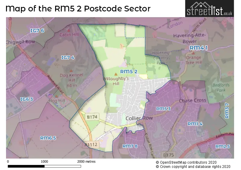
The RM5 2 Postcode shares a border with RM4 1 (LAMBOURNE , STAPLEFORD ABBOTTS , HAVERING-ATTE-BOWER ), RM7 8 (ROMFORD , MAWNEYS ), RM5 3 (ROMFORD , COLLIER ROW ), RM6 5 (CHADWELL HEATH , ROMFORD ) and IG7 4 (CHIGWELL ).
The sector is within the post town of ROMFORD.
RM5 2 is a postcode sector within the RM5 postcode district which is within the RM Romford postcode area.
The Royal Mail delivery office for the RM5 2 postal sector is the Romford Delivery Office.
The area of the RM5 2 postcode sector is 2.13 square miles which is 5.52 square kilometres or 1,364.89 square acres.

Map of the RM5 2 Postcode Sector
Explore the RM5 2 postcode sector by using our free interactive map.
| R | M | 5 | - | 2 | X | X |
| R | M | 5 | Space | 2 | Letter | Letter |
Official List of Streets
ROMFORD (80 Streets)
Collier Row (4 Streets)
Unofficial Streets or Alternative Spellings
ROMFORD
HOOD WALK RODNEY WAY VERNON ROAD WHALEBONE LANE NORTH WHITE HART LANEHavering-Atte-Bower
KILN WOOD LANE PINEWOOD ROAD WELLINGTONIA AVENUE BACON LINK HAMPDEN ROAD PROVIDENCE PLACE WELLGATE FARMCHIGWELL,
ROMFORD ROADWeather Forecast for RM5 2
Press Button to Show Forecast for Romford
| Time Period | Icon | Description | Temperature | Rain Probability | Wind |
|---|---|---|---|---|---|
| 18:00 to 21:00 | Cloudy | 9.0°C (feels like 7.0°C) | 5.00% | N 11 mph | |
| 21:00 to 00:00 | Cloudy | 7.0°C (feels like 5.0°C) | 4.00% | N 7 mph |
Press Button to Show Forecast for Romford
| Time Period | Icon | Description | Temperature | Rain Probability | Wind |
|---|---|---|---|---|---|
| 00:00 to 03:00 | Clear night | 6.0°C (feels like 3.0°C) | 0.00% | NW 7 mph | |
| 03:00 to 06:00 | Clear night | 4.0°C (feels like 1.0°C) | 0.00% | NNW 9 mph | |
| 06:00 to 09:00 | Partly cloudy (day) | 4.0°C (feels like 1.0°C) | 1.00% | NNW 9 mph | |
| 09:00 to 12:00 | Cloudy | 8.0°C (feels like 5.0°C) | 4.00% | NNW 13 mph | |
| 12:00 to 15:00 | Cloudy | 10.0°C (feels like 8.0°C) | 4.00% | NNW 13 mph | |
| 15:00 to 18:00 | Cloudy | 11.0°C (feels like 8.0°C) | 5.00% | NNW 11 mph | |
| 18:00 to 21:00 | Cloudy | 9.0°C (feels like 7.0°C) | 4.00% | N 9 mph | |
| 21:00 to 00:00 | Clear night | 7.0°C (feels like 5.0°C) | 1.00% | NE 4 mph |
Press Button to Show Forecast for Romford
| Time Period | Icon | Description | Temperature | Rain Probability | Wind |
|---|---|---|---|---|---|
| 00:00 to 03:00 | Cloudy | 5.0°C (feels like 4.0°C) | 4.00% | WSW 4 mph | |
| 03:00 to 06:00 | Cloudy | 5.0°C (feels like 3.0°C) | 4.00% | WSW 4 mph | |
| 06:00 to 09:00 | Cloudy | 6.0°C (feels like 4.0°C) | 5.00% | WSW 7 mph | |
| 09:00 to 12:00 | Cloudy | 9.0°C (feels like 7.0°C) | 7.00% | W 9 mph | |
| 12:00 to 15:00 | Cloudy | 11.0°C (feels like 9.0°C) | 9.00% | WNW 9 mph | |
| 15:00 to 18:00 | Overcast | 12.0°C (feels like 10.0°C) | 14.00% | WNW 9 mph | |
| 18:00 to 21:00 | Overcast | 10.0°C (feels like 9.0°C) | 14.00% | NW 7 mph | |
| 21:00 to 00:00 | Cloudy | 8.0°C (feels like 6.0°C) | 7.00% | NNE 4 mph |
Press Button to Show Forecast for Romford
| Time Period | Icon | Description | Temperature | Rain Probability | Wind |
|---|---|---|---|---|---|
| 00:00 to 03:00 | Cloudy | 6.0°C (feels like 5.0°C) | 4.00% | NE 4 mph | |
| 03:00 to 06:00 | Cloudy | 5.0°C (feels like 4.0°C) | 5.00% | NE 4 mph | |
| 06:00 to 09:00 | Cloudy | 6.0°C (feels like 4.0°C) | 7.00% | ENE 4 mph | |
| 09:00 to 12:00 | Cloudy | 9.0°C (feels like 7.0°C) | 7.00% | E 7 mph | |
| 12:00 to 15:00 | Overcast | 11.0°C (feels like 9.0°C) | 13.00% | SE 9 mph | |
| 15:00 to 18:00 | Cloudy | 11.0°C (feels like 9.0°C) | 12.00% | SE 9 mph | |
| 18:00 to 21:00 | Cloudy | 10.0°C (feels like 8.0°C) | 11.00% | ESE 9 mph | |
| 21:00 to 00:00 | Cloudy | 8.0°C (feels like 6.0°C) | 10.00% | ESE 7 mph |
Press Button to Show Forecast for Romford
| Time Period | Icon | Description | Temperature | Rain Probability | Wind |
|---|---|---|---|---|---|
| 00:00 to 03:00 | Overcast | 8.0°C (feels like 6.0°C) | 17.00% | ESE 7 mph | |
| 03:00 to 06:00 | Cloudy | 7.0°C (feels like 6.0°C) | 15.00% | E 7 mph | |
| 06:00 to 09:00 | Overcast | 8.0°C (feels like 6.0°C) | 16.00% | E 7 mph | |
| 09:00 to 12:00 | Cloudy | 11.0°C (feels like 9.0°C) | 12.00% | SE 9 mph | |
| 12:00 to 15:00 | Light rain | 13.0°C (feels like 11.0°C) | 40.00% | ESE 9 mph | |
| 15:00 to 18:00 | Light rain shower (day) | 13.0°C (feels like 11.0°C) | 32.00% | ESE 9 mph | |
| 18:00 to 21:00 | Cloudy | 12.0°C (feels like 11.0°C) | 14.00% | ENE 9 mph | |
| 21:00 to 00:00 | Cloudy | 11.0°C (feels like 9.0°C) | 12.00% | ENE 7 mph |
Schools and Places of Education Within the RM5 2 Postcode Sector
Oasis Academy Pinewood
Academy sponsor led
Thistledene Avenue, Romford, Essex, RM5 2TX
Head: Miss Jenni Elliott
Ofsted Rating: Good
Inspection: 2021-11-11 (894 days ago)
Website: Visit Oasis Academy Pinewood Website
Phone: 01708743000
Number of Pupils: 366
St Patrick's Catholic Primary School
Voluntary aided school
Lowshoe Lane, Romford, Essex, RM5 2AP
Head: Mrs Sharon Newman
Ofsted Rating: Good
Inspection: 2022-01-12 (832 days ago)
Website: Visit St Patrick's Catholic Primary School Website
Phone: 01708745655
Number of Pupils: 389
House Prices in the RM5 2 Postcode Sector
| Type of Property | 2018 Average | 2018 Sales | 2017 Average | 2017 Sales | 2016 Average | 2016 Sales | 2015 Average | 2015 Sales |
|---|---|---|---|---|---|---|---|---|
| Detached | £503,333 | 6 | £409,000 | 2 | £424,000 | 5 | £400,813 | 8 |
| Semi-Detached | £361,915 | 59 | £364,112 | 73 | £371,446 | 74 | £302,199 | 68 |
| Terraced | £342,100 | 53 | £351,820 | 50 | £326,213 | 47 | £282,921 | 55 |
| Flats | £205,389 | 9 | £229,727 | 11 | £191,283 | 15 | £212,812 | 8 |
Important Postcodes RM5 2 in the Postcode Sector
RM5 2AP is the postcode for MAIN BUILDING, St. Patricks School, Lowshoe Lane, and St. Patricks School, Lowshoe Lane
RM5 2TX is the postcode for Pinewood Primary School, Thistledene Avenue, Oasis Academy Pinewood, Thistledene Avenue, and JUNIOR BLOCK, Oasis Academy Pinewood, Thistledene Avenue
| The RM5 2 Sector is within these Local Authorities |
|
|---|---|
| The RM5 2 Sector is within these Counties |
|
| The RM5 2 Sector is within these Water Company Areas |
|