The RM9 5 postcode sector is within the county of Greater London.
Did you know? According to the 2021 Census, the RM9 5 postcode sector is home to a bustling 13,431 residents!
Given that each sector allows for 400 unique postcode combinations. Letters C, I, K, M, O and V are not allowed in the last two letters of a postcode. With 177 postcodes already in use, this leaves 223 units available.
The RM9 5 postal code covers the settlement of DAGENHAM .
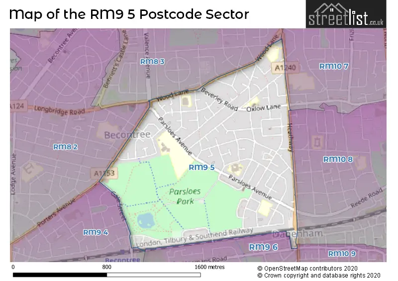
The RM9 5 Postcode shares a border with RM9 4 (DAGENHAM ), RM10 8 (DAGENHAM ), RM10 9 (DAGENHAM ), RM8 2 (DAGENHAM ), RM8 3 (DAGENHAM ), RM9 6 (DAGENHAM ) and RM10 7 (DAGENHAM ).
The sector is within the post town of DAGENHAM.
RM9 5 is a postcode sector within the RM9 postcode district which is within the RM Romford postcode area.
The Royal Mail delivery office for the RM9 5 postal sector is the Dagenham Delivery Office.
The area of the RM9 5 postcode sector is 0.77 square miles which is 1.98 square kilometres or 490.39 square acres.

Map of the RM9 5 Postcode Sector
Explore the RM9 5 postcode sector by using our free interactive map.
| R | M | 9 | - | 5 | X | X |
| R | M | 9 | Space | 5 | Letter | Letter |
Official List of Streets
DAGENHAM (69 Streets)
Unofficial Streets or Alternative Spellings
DAGENHAM
AYLMER ROAD BONHAM ROAD FITZSTEPHEN ROAD GALE STREET HEDGEMANS ROAD ILCHESTER ROAD OGLETHORPE ROAD POWELL GARDENS REEDE ROAD ROBINSON ROAD RUGBY ROAD RUSPER ROAD VALENCE AVENUE WAYSIDE GARDENS WEYLOND ROAD WINDSOR ROAD WINMILL ROAD WROXALL ROAD WYKEHAM AVENUE PETTITS ROAD STATION PARADE, HEATHWAY TRINITY SCHOOL TURNER COURT WESTFIELD GARDENS WINDMILL ROADWeather Forecast for RM9 5
Press Button to Show Forecast for Dagenham
| Time Period | Icon | Description | Temperature | Rain Probability | Wind |
|---|---|---|---|---|---|
| 03:00 to 06:00 | Clear night | 5.0°C (feels like 2.0°C) | 0.00% | NNW 9 mph | |
| 06:00 to 09:00 | Partly cloudy (day) | 5.0°C (feels like 2.0°C) | 1.00% | NNW 9 mph | |
| 09:00 to 12:00 | Cloudy | 8.0°C (feels like 5.0°C) | 4.00% | NNW 11 mph | |
| 12:00 to 15:00 | Cloudy | 10.0°C (feels like 8.0°C) | 4.00% | NNW 11 mph | |
| 15:00 to 18:00 | Cloudy | 11.0°C (feels like 8.0°C) | 5.00% | N 11 mph | |
| 18:00 to 21:00 | Cloudy | 10.0°C (feels like 8.0°C) | 4.00% | N 9 mph | |
| 21:00 to 00:00 | Clear night | 7.0°C (feels like 6.0°C) | 1.00% | NE 4 mph |
Press Button to Show Forecast for Dagenham
| Time Period | Icon | Description | Temperature | Rain Probability | Wind |
|---|---|---|---|---|---|
| 00:00 to 03:00 | Cloudy | 6.0°C (feels like 5.0°C) | 4.00% | WSW 4 mph | |
| 03:00 to 06:00 | Cloudy | 5.0°C (feels like 4.0°C) | 3.00% | WSW 4 mph | |
| 06:00 to 09:00 | Cloudy | 6.0°C (feels like 4.0°C) | 4.00% | WSW 7 mph | |
| 09:00 to 12:00 | Cloudy | 9.0°C (feels like 7.0°C) | 5.00% | W 9 mph | |
| 12:00 to 15:00 | Cloudy | 11.0°C (feels like 9.0°C) | 8.00% | WNW 9 mph | |
| 15:00 to 18:00 | Overcast | 12.0°C (feels like 10.0°C) | 11.00% | WNW 9 mph | |
| 18:00 to 21:00 | Cloudy | 11.0°C (feels like 9.0°C) | 11.00% | NW 7 mph | |
| 21:00 to 00:00 | Cloudy | 8.0°C (feels like 7.0°C) | 8.00% | NNE 4 mph |
Press Button to Show Forecast for Dagenham
| Time Period | Icon | Description | Temperature | Rain Probability | Wind |
|---|---|---|---|---|---|
| 00:00 to 03:00 | Cloudy | 7.0°C (feels like 6.0°C) | 5.00% | ENE 4 mph | |
| 03:00 to 06:00 | Cloudy | 6.0°C (feels like 4.0°C) | 5.00% | NE 4 mph | |
| 06:00 to 09:00 | Cloudy | 6.0°C (feels like 4.0°C) | 7.00% | ENE 4 mph | |
| 09:00 to 12:00 | Cloudy | 9.0°C (feels like 7.0°C) | 8.00% | E 7 mph | |
| 12:00 to 15:00 | Overcast | 11.0°C (feels like 9.0°C) | 15.00% | SE 7 mph | |
| 15:00 to 18:00 | Cloudy | 11.0°C (feels like 9.0°C) | 14.00% | ESE 9 mph | |
| 18:00 to 21:00 | Cloudy | 10.0°C (feels like 8.0°C) | 13.00% | ESE 9 mph | |
| 21:00 to 00:00 | Cloudy | 9.0°C (feels like 7.0°C) | 11.00% | ESE 7 mph |
Press Button to Show Forecast for Dagenham
| Time Period | Icon | Description | Temperature | Rain Probability | Wind |
|---|---|---|---|---|---|
| 00:00 to 03:00 | Cloudy | 8.0°C (feels like 6.0°C) | 13.00% | ESE 7 mph | |
| 03:00 to 06:00 | Cloudy | 8.0°C (feels like 6.0°C) | 14.00% | ESE 4 mph | |
| 06:00 to 09:00 | Cloudy | 8.0°C (feels like 6.0°C) | 13.00% | ESE 7 mph | |
| 09:00 to 12:00 | Cloudy | 11.0°C (feels like 9.0°C) | 12.00% | ESE 9 mph | |
| 12:00 to 15:00 | Light rain | 13.0°C (feels like 11.0°C) | 40.00% | SE 9 mph | |
| 15:00 to 18:00 | Light rain shower (day) | 13.0°C (feels like 11.0°C) | 33.00% | ESE 9 mph | |
| 18:00 to 21:00 | Light rain shower (day) | 13.0°C (feels like 11.0°C) | 31.00% | SE 9 mph | |
| 21:00 to 00:00 | Cloudy | 11.0°C (feels like 10.0°C) | 12.00% | ENE 7 mph |
Schools and Places of Education Within the RM9 5 Postcode Sector
Five Elms Primary School
Community school
Wood Lane, Dagenham, Essex, RM9 5TB
Head: Mrs Barbara Turner
Ofsted Rating: Good
Inspection: 2022-10-06 (566 days ago)
Website: Visit Five Elms Primary School Website
Phone: 02082704909
Number of Pupils: 457
Parsloes Primary School
Community school
Spurling Road, Dagenham, Essex, RM9 5RH
Head: Mrs Lauren Pearce
Ofsted Rating: Good
Inspection: 2023-01-25 (455 days ago)
Website: Visit Parsloes Primary School Website
Phone: 02082704925
Number of Pupils: 393
Southwood Primary School
Community school
Keppel Road, Dagenham, Essex, RM9 5LT
Head: Mr Scott Halliwell
Ofsted Rating: Good
Inspection: 2023-07-04 (295 days ago)
Website: Visit Southwood Primary School Website
Phone: 02082704915
Number of Pupils: 618
St Joseph's Catholic Primary School
Academy converter
Connor Road, Dagenham, Essex, RM9 5UL
Head: Mrs Natalie Holden
Ofsted Rating: Good
Inspection: 2023-06-28 (301 days ago)
Website: Visit St Joseph's Catholic Primary School Website
Phone: 02082706480
Number of Pupils: 319
The Sydney Russell School
Academy converter
Parsloes Avenue, Dagenham, Essex, RM9 5QT
Head: Mrs Clare Cross
Ofsted Rating: Good
Inspection: 2021-09-16 (951 days ago)
Website: Visit The Sydney Russell School Website
Phone: 02039599900
Number of Pupils: 2557
House Prices in the RM9 5 Postcode Sector
| Type of Property | 2018 Average | 2018 Sales | 2017 Average | 2017 Sales | 2016 Average | 2016 Sales | 2015 Average | 2015 Sales |
|---|---|---|---|---|---|---|---|---|
| Detached | £0 | 0 | £0 | 0 | £320,000 | 1 | £0 | 0 |
| Semi-Detached | £331,917 | 12 | £323,611 | 9 | £338,375 | 16 | £278,600 | 10 |
| Terraced | £305,263 | 116 | £294,585 | 110 | £293,579 | 135 | £246,559 | 131 |
| Flats | £198,167 | 6 | £182,400 | 10 | £172,746 | 12 | £155,964 | 14 |
Important Postcodes RM9 5 in the Postcode Sector
RM9 5AA is the postcode for CHESNUT NURSERY SCHOOL, 202A HALBUTT STREET
RM9 5AJ is the postcode for MAIN BUILDING, Valence Primary School, St. Georges Road, Valence Primary School, St. Georges Road, Valence Primary School - Carol Jolley Building, St. Georges Road, Valence Primary School - Main Building, St. Georges Road, and CAROL JOLLEY, Valence Primary School, St. Georges Road
RM9 5AR is the postcode for Fanshawe Health Centre, Halbutt Street
RM9 5DF is the postcode for Adult College of Barking and Dagenham, 241-247 Parsloes Avenue
RM9 5DX is the postcode for Fanshawe Community Complex, Barnmead Road, and HALL & LIBRARY, Fanshawe Community Complex, Barnmead Road
RM9 5LT is the postcode for NEW BUILD 2012, Southwood School, Keppel Road, and Southwood School, Keppel Road
RM9 5QA is the postcode for Sydney Russell Primary School, Fanshawe Crescent, and Sydney Russell School - Primary, Fanshawe Crescent
RM9 5QT is the postcode for NORRIS BUILDING, Sydney Russell School, Parsloes Avenue, KINGSLEY BLOCK & SPORTS CENTRE, Sydney Russell School, Parsloes Avenue, LESTER BLOCK, Sydney Russell School, Parsloes Avenue, DURANT BLOCK, Sydney Russell School, Parsloes Avenue, SHAFTESBURY BLOCK, Sydney Russell School, Parsloes Avenue, and CANTEEN BLOCK, Sydney Russell School, Parsloes Avenue
RM9 5RH is the postcode for SCHOOL HOUSE, Parsloes Primary School, Spurling Road, and Parsloes Primary School, Spurling Road
RM9 5TB is the postcode for Five Elms School, Wood Lane
RM9 5TT is the postcode for Five Elms Health Centre, Five Elms Road
RM9 5UH is the postcode for Royal Mail, Dagenham Delivery Office, Boxoll Road
RM9 5UL is the postcode for St Josephs RC School - Main Building, Connor Road, NEW BUILD, St. Joseph School, Connor Road, and St. Joseph School, Connor Road
| The RM9 5 Sector is within these Local Authorities |
|
|---|---|
| The RM9 5 Sector is within these Counties |
|
| The RM9 5 Sector is within these Water Company Areas |
|