The S10 postcode district is a postal district located in the S Sheffield postcode area with a population of 45,915 residents according to the 2021 England and Wales Census.
The area of the S10 postcode district is 11.50 square miles which is 29.79 square kilometres or 7,360.60 acres.
Currently, the S10 district has about 918 postcode units spread across 5 geographic postcode sectors.
Given that each sector allows for 400 unique postcode combinations, the district has a capacity of 2,000 postcodes. With 918 postcodes already in use, this leaves 1082 units available.
The S10 postal code covers the settlement of SHEFFIELD.
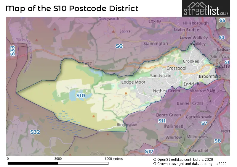
The S10 Postcode shares a border with S11 (SHEFFIELD), S6 (SHEFFIELD, Stannington, Loxley) and S3 (SHEFFIELD).
The primary settlement in the S10 postcode district is Sheffield, which is located in the county of South Yorkshire.
For the district S10, we have data on 6 postcode sectors. Here's a breakdown: The sector S10 1, covers Sheffield in South Yorkshire. The sector S10 2, covers Sheffield in South Yorkshire. The sector S10 3, covers Sheffield in South Yorkshire. The sector S10 4, covers Sheffield in South Yorkshire. The sector S10 5, covers Sheffield in South Yorkshire. The sector S10 9 is non-geographic. It's often designated for PO Boxes, large organisations, or special services.


Map of the S10 Postcode District
Explore the S10 postcode district by using our free interactive map.
When it comes to local government, postal geography often disregards political borders. However, for a breakdown in the S10 District: the district mostly encompasses the Sheffield District (B) area with a total of 932 postcodes.
Recent House Sales in S10
| Date | Price | Address |
|---|---|---|
| 20/10/2023 | £279,000 | Parkers Road, Sheffield, S10 1BN |
| 18/10/2023 | £465,000 | Rochester Road, Sheffield, S10 4JQ |
| 06/10/2023 | £268,200 | Clementson Road, Sheffield, S10 1GS |
| 04/10/2023 | £115,000 | Manchester Road, Sheffield, S10 5DN |
| 03/10/2023 | £165,000 | Manchester Road, Sheffield, S10 5DQ |
| 02/10/2023 | £172,000 | Manchester Road, Sheffield, S10 5DQ |
| 21/09/2023 | £610,000 | Blackbrook Avenue, Sheffield, S10 4LT |
| 21/09/2023 | £218,000 | Benty Lane, Sheffield, S10 5NF |
| 18/09/2023 | £295,000 | Tapton Mount Close, Sheffield, S10 5DJ |
| 14/09/2023 | £132,500 | Stannington View Road, Sheffield, S10 1SS |
Weather Forecast for S10
Press Button to Show Forecast for Hallam Head
| Time Period | Icon | Description | Temperature | Rain Probability | Wind |
|---|---|---|---|---|---|
| 18:00 to 21:00 | Cloudy | 6.0°C (feels like 3.0°C) | 6.00% | NNE 7 mph | |
| 21:00 to 00:00 | Partly cloudy (night) | 3.0°C (feels like 1.0°C) | 37.00% | NNE 4 mph |
Press Button to Show Forecast for Hallam Head
| Time Period | Icon | Description | Temperature | Rain Probability | Wind |
|---|---|---|---|---|---|
| 00:00 to 03:00 | Cloudy | 2.0°C (feels like 0.0°C) | 4.00% | ENE 4 mph | |
| 03:00 to 06:00 | Clear night | 0.0°C (feels like -2.0°C) | 1.00% | N 4 mph | |
| 06:00 to 09:00 | Sunny day | 1.0°C (feels like -1.0°C) | 1.00% | N 4 mph | |
| 09:00 to 12:00 | Cloudy | 4.0°C (feels like 2.0°C) | 5.00% | ENE 4 mph | |
| 12:00 to 15:00 | Overcast | 7.0°C (feels like 5.0°C) | 9.00% | ENE 4 mph | |
| 15:00 to 18:00 | Overcast | 7.0°C (feels like 6.0°C) | 9.00% | E 4 mph | |
| 18:00 to 21:00 | Cloudy | 6.0°C (feels like 4.0°C) | 9.00% | E 7 mph | |
| 21:00 to 00:00 | Cloudy | 3.0°C (feels like 1.0°C) | 8.00% | ENE 7 mph |
Press Button to Show Forecast for Hallam Head
| Time Period | Icon | Description | Temperature | Rain Probability | Wind |
|---|---|---|---|---|---|
| 00:00 to 03:00 | Cloudy | 2.0°C (feels like 0.0°C) | 8.00% | NE 4 mph | |
| 03:00 to 06:00 | Cloudy | 1.0°C (feels like -1.0°C) | 11.00% | NE 4 mph | |
| 06:00 to 09:00 | Cloudy | 2.0°C (feels like 0.0°C) | 11.00% | NE 7 mph | |
| 09:00 to 12:00 | Cloudy | 6.0°C (feels like 3.0°C) | 12.00% | ENE 9 mph | |
| 12:00 to 15:00 | Overcast | 8.0°C (feels like 5.0°C) | 20.00% | E 11 mph | |
| 15:00 to 18:00 | Cloudy | 8.0°C (feels like 5.0°C) | 22.00% | ENE 11 mph | |
| 18:00 to 21:00 | Cloudy | 7.0°C (feels like 4.0°C) | 20.00% | ENE 11 mph | |
| 21:00 to 00:00 | Cloudy | 5.0°C (feels like 1.0°C) | 18.00% | ENE 11 mph |
Press Button to Show Forecast for Hallam Head
| Time Period | Icon | Description | Temperature | Rain Probability | Wind |
|---|---|---|---|---|---|
| 00:00 to 03:00 | Light rain | 4.0°C (feels like 1.0°C) | 51.00% | NE 11 mph | |
| 03:00 to 06:00 | Light rain | 4.0°C (feels like 1.0°C) | 51.00% | NNE 11 mph | |
| 06:00 to 09:00 | Heavy rain | 5.0°C (feels like 1.0°C) | 76.00% | NNE 13 mph | |
| 09:00 to 12:00 | Heavy rain | 6.0°C (feels like 2.0°C) | 79.00% | NNE 13 mph | |
| 12:00 to 15:00 | Light rain | 7.0°C (feels like 4.0°C) | 56.00% | NNE 13 mph | |
| 15:00 to 18:00 | Light rain | 8.0°C (feels like 5.0°C) | 54.00% | NNE 11 mph | |
| 18:00 to 21:00 | Light rain shower (day) | 7.0°C (feels like 5.0°C) | 35.00% | NNW 9 mph | |
| 21:00 to 00:00 | Partly cloudy (night) | 6.0°C (feels like 3.0°C) | 10.00% | NNE 9 mph |
Where is the S10 Postcode District?
The data indicates that the S10 postcode district is located in the town of Sheffield. This district is surrounded by several nearby towns, including Dronfield to the South East, Rotherham to the North East, Bakewell to the South West, Barnsley to the North, Holmfirth to the North West, and Glossop to the West. Additionally, the distance between Sheffield and the centre of London is approximately 142.41 miles.
The district is within the post town of SHEFFIELD.
The sector has postcodes within the nation of England.
The S10 Postcode District is in the Sheffield region of South Yorkshire within the Yorkshire and The Humber.
| Postcode Sector | Delivery Office |
|---|---|
| S10 1 | Sheffield Wpostal Delivery Office |
| S10 2 | Sheffield Wpostal Delivery Office |
| S10 3 | Sheffield Wpostal Delivery Office |
| S10 4 | Sheffield Wpostal Delivery Office |
| S10 5 | Sheffield Wpostal Delivery Office |
| S | 1 | 0 | - | X | X | X |
| S | 1 | 0 | Space | Numeric | Letter | Letter |
Tourist Attractions within the Postcode Area
We found 2 visitor attractions within the S10 postcode area
| Sheffield Botanical Gardens |
|---|
| Gardens |
| Garden |
| View Sheffield Botanical Gardens on Google Maps |
| Museums Sheffield: Weston Park |
| Museums & Art Galleries |
| Museum and / or Art Gallery |
| View Museums Sheffield: Weston Park on Google Maps |
Current Monthly Rental Prices
| # Bedrooms | Min Price | Max Price | Avg Price |
|---|---|---|---|
| £425 | £750 | £633 | |
| 1 | £455 | £1,100 | £683 |
| 2 | £850 | £2,495 | £1,202 |
| 3 | £368 | £4,500 | £1,392 |
| 4 | £325 | £2,000 | £1,190 |
| 5 | £295 | £1,569 | £604 |
| 6 | £303 | £2,600 | £888 |
| 7 | £325 | £325 | £325 |
Current House Prices
| # Bedrooms | Min Price | Max Price | Avg Price |
|---|---|---|---|
| £75,000 | £2,200,000 | £593,000 | |
| 1 | £30,000 | £284,950 | £153,594 |
| 2 | £82,000 | £550,000 | £271,466 |
| 3 | £195,000 | £725,000 | £415,089 |
| 4 | £230,000 | £1,325,000 | £538,831 |
| 5 | £280,000 | £2,799,950 | £929,330 |
| 6 | £775,000 | £775,000 | £775,000 |
| 7 | £1,200,000 | £2,100,000 | £1,516,667 |
| 9 | £625,000 | £645,000 | £635,000 |
Estate Agents who Operate in the S10 District
| Logo | Name | Brand Name | Address | Contact Number | Total Properties |
|---|---|---|---|---|---|
 | Sheffield | Archers | 41 Sandygate Road, Sheffield, S10 5NG | 0114 697 1462 | 17 |
 | Sheffield | Evans Lee | 217 Oakbrook Road, Sheffield, S11 7EB | 0114 697 2347 | 15 |
 | Sheffield | Saxton Mee | 949-951 Ecclesall Road Sheffield S11 8TN | 0114 697 1645 | 14 |
 | Banner Cross | Whitehornes | 952 Ecclesall Road, Sheffield, S11 8TR | 0114 697 3517 | 14 |
 | Sheffield | haus | West Bar House 137 West Bar Sheffield S3 8PT | 0114 697 9240 | 11 |
| Type of Property | 2018 Average | 2018 Sales | 2017 Average | 2017 Sales | 2016 Average | 2016 Sales | 2015 Average | 2015 Sales |
|---|---|---|---|---|---|---|---|---|
| Detached | £539,494 | 132 | £498,445 | 144 | £515,744 | 131 | £457,300 | 142 |
| Semi-Detached | £347,111 | 158 | £317,594 | 189 | £326,490 | 153 | £313,721 | 180 |
| Terraced | £225,620 | 244 | £220,194 | 261 | £221,125 | 268 | £192,955 | 266 |
| Flats | £196,435 | 123 | £182,541 | 187 | £185,605 | 202 | £165,645 | 176 |