The S12 postcode district is a postal district located in the S Sheffield postcode area with a population of 34,202 residents according to the 2021 England and Wales Census.
The area of the S12 postcode district is 5.92 square miles which is 15.33 square kilometres or 3,786.91 acres.
Currently, the S12 district has about 651 postcode units spread across 3 geographic postcode sectors.
Given that each sector allows for 400 unique postcode combinations, the district has a capacity of 1,200 postcodes. With 651 postcodes already in use, this leaves 549 units available.
The largest settlement in the S12 postal code is SHEFFIELD followed by Ridgeway, and Hackenthorpe.
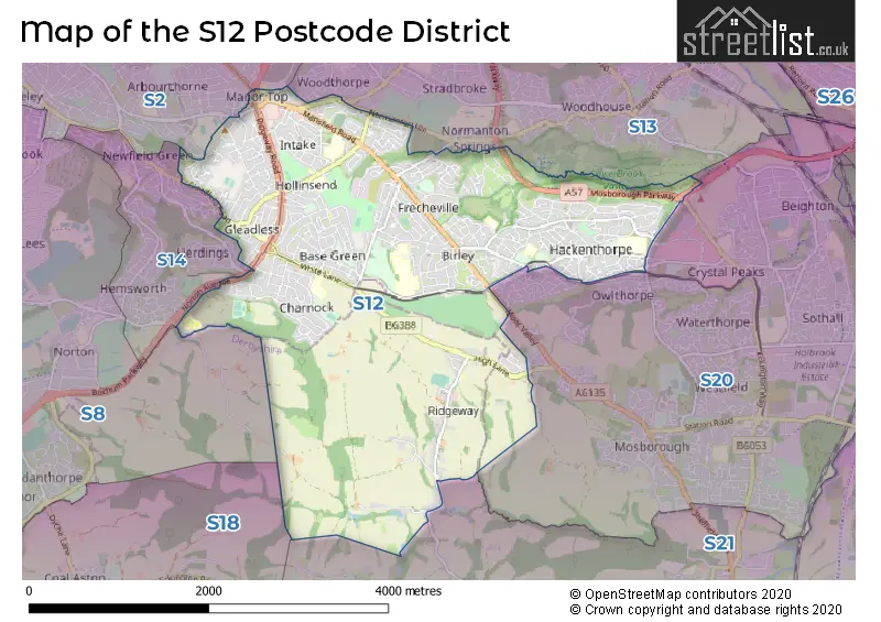
The S12 Postcode shares a border with S13 (SHEFFIELD, Woodhouse, Handsworth), S14 (SHEFFIELD), S2 (SHEFFIELD, Park Hill), S20 (Beighton, Halfway, Mosborough), S21 (Killamarsh, Eckington, Renishaw) and S8 (SHEFFIELD).
The primary settlement in the S12 postcode district is Sheffield, located in the county of South Yorkshire, England.
For the district S12, we have data on 4 postcode sectors. Here's a breakdown: The sector S12 2, covers Sheffield in South Yorkshire. The sector S12 3, covers Sheffield in South Yorkshire. The sector S12 4, covers Sheffield in South Yorkshire. The sector S12 9 is non-geographic. It's often designated for PO Boxes, large organisations, or special services.

Map of the S12 Postcode District
Explore the S12 postcode district by using our free interactive map.
When it comes to local government, postal geography often disregards political borders. However, for a breakdown in the S12 District: the district mostly encompasses the Sheffield District (B) (638 postcodes), and finally, the North East Derbyshire District area (16 postcodes).
Recent House Sales in S12
| Date | Price | Address |
|---|---|---|
| 18/10/2023 | £140,000 | Greenacre Way, Sheffield, S12 2TZ |
| 29/09/2023 | £185,500 | Willbury Drive, Sheffield, S12 2TG |
| 29/09/2023 | £187,500 | Hollybank Avenue, Sheffield, S12 2BL |
| 27/09/2023 | £73,638 | Delves Avenue, Hackenthorpe, Sheffield, S12 4AB |
| 22/09/2023 | £260,000 | Fairmount Gardens, Sheffield, S12 4JZ |
| 22/09/2023 | £250,000 | Silkstone Road, Sheffield, S12 4RH |
| 12/09/2023 | £245,000 | Westfield Avenue, Sheffield, S12 4LL |
| 12/09/2023 | £225,000 | Westfield Avenue, Sheffield, S12 4LL |
| 09/09/2023 | £152,500 | Jaunty Avenue, Sheffield, S12 3DE |
| 08/09/2023 | £201,500 | Lister Avenue, Sheffield, S12 3FN |
Weather Forecast for S12
Press Button to Show Forecast for Gleadless Townend
| Time Period | Icon | Description | Temperature | Rain Probability | Wind |
|---|---|---|---|---|---|
| 21:00 to 00:00 | Cloudy | 4.0°C (feels like 2.0°C) | 5.00% | NNE 4 mph |
Press Button to Show Forecast for Gleadless Townend
| Time Period | Icon | Description | Temperature | Rain Probability | Wind |
|---|---|---|---|---|---|
| 00:00 to 03:00 | Partly cloudy (night) | 3.0°C (feels like 1.0°C) | 2.00% | NE 4 mph | |
| 03:00 to 06:00 | Clear night | 2.0°C (feels like 0.0°C) | 1.00% | N 4 mph | |
| 06:00 to 09:00 | Sunny day | 2.0°C (feels like 0.0°C) | 1.00% | N 4 mph | |
| 09:00 to 12:00 | Cloudy | 5.0°C (feels like 3.0°C) | 5.00% | NE 7 mph | |
| 12:00 to 15:00 | Overcast | 8.0°C (feels like 6.0°C) | 9.00% | ENE 4 mph | |
| 15:00 to 18:00 | Overcast | 9.0°C (feels like 8.0°C) | 9.00% | ENE 4 mph | |
| 18:00 to 21:00 | Cloudy | 7.0°C (feels like 5.0°C) | 8.00% | ENE 7 mph | |
| 21:00 to 00:00 | Cloudy | 4.0°C (feels like 2.0°C) | 8.00% | ENE 4 mph |
Press Button to Show Forecast for Gleadless Townend
| Time Period | Icon | Description | Temperature | Rain Probability | Wind |
|---|---|---|---|---|---|
| 00:00 to 03:00 | Cloudy | 3.0°C (feels like 2.0°C) | 8.00% | NNE 4 mph | |
| 03:00 to 06:00 | Cloudy | 2.0°C (feels like 1.0°C) | 10.00% | NNE 4 mph | |
| 06:00 to 09:00 | Cloudy | 3.0°C (feels like 1.0°C) | 11.00% | NNE 4 mph | |
| 09:00 to 12:00 | Cloudy | 7.0°C (feels like 4.0°C) | 12.00% | ENE 9 mph | |
| 12:00 to 15:00 | Overcast | 9.0°C (feels like 7.0°C) | 18.00% | E 9 mph | |
| 15:00 to 18:00 | Cloudy | 9.0°C (feels like 7.0°C) | 22.00% | ENE 9 mph | |
| 18:00 to 21:00 | Cloudy | 8.0°C (feels like 6.0°C) | 20.00% | ENE 9 mph | |
| 21:00 to 00:00 | Cloudy | 6.0°C (feels like 3.0°C) | 18.00% | NE 9 mph |
Press Button to Show Forecast for Gleadless Townend
| Time Period | Icon | Description | Temperature | Rain Probability | Wind |
|---|---|---|---|---|---|
| 00:00 to 03:00 | Light rain | 6.0°C (feels like 2.0°C) | 49.00% | NNE 11 mph | |
| 03:00 to 06:00 | Light rain | 6.0°C (feels like 2.0°C) | 51.00% | NNE 11 mph | |
| 06:00 to 09:00 | Heavy rain | 6.0°C (feels like 2.0°C) | 76.00% | NNE 13 mph | |
| 09:00 to 12:00 | Heavy rain | 7.0°C (feels like 4.0°C) | 79.00% | NNE 11 mph | |
| 12:00 to 15:00 | Heavy rain | 8.0°C (feels like 5.0°C) | 77.00% | NE 13 mph | |
| 15:00 to 18:00 | Light rain | 9.0°C (feels like 6.0°C) | 51.00% | N 11 mph | |
| 18:00 to 21:00 | Light rain shower (day) | 9.0°C (feels like 7.0°C) | 36.00% | N 9 mph | |
| 21:00 to 00:00 | Partly cloudy (night) | 6.0°C (feels like 5.0°C) | 11.00% | SE 7 mph |
Where is the S12 Postcode District?
The postcode district S12 is located in Sheffield, a district town in South Yorkshire. It is in close proximity to several nearby towns. To the South West, there is Dronfield, situated approximately 3.84 miles away. Rotherham is found in the North East, about 7.44 miles away. Chesterfield lies to the South, around 7.50 miles away. Worksop is located in the East direction, approximately 12.40 miles away. Lastly, Barnsley is situated to the North, approximately 14.63 miles away. Additionally, the distance from S12 to the center of London is 137.72 miles.
The district is within the post town of SHEFFIELD.
The sector has postcodes within the nation of England.
The S12 Postcode District is covers the following regions.
- Sheffield - South Yorkshire - Yorkshire and The Humber
- East Derbyshire - Derbyshire and Nottinghamshire - East Midlands (England)
| Postcode Sector | Delivery Office |
|---|---|
| S12 2 | Sheffield Sepostal Delivery Office |
| S12 3 | Sheffield Sepostal Delivery Office |
| S12 4 | Sheffield Sepostal Delivery Office |
| S | 1 | 2 | - | X | X | X |
| S | 1 | 2 | Space | Numeric | Letter | Letter |
Current Monthly Rental Prices
| # Bedrooms | Min Price | Max Price | Avg Price |
|---|---|---|---|
| 1 | £500 | £500 | £500 |
| 2 | £750 | £795 | £761 |
| 3 | £850 | £850 | £850 |
Current House Prices
| # Bedrooms | Min Price | Max Price | Avg Price |
|---|---|---|---|
| £350,000 | £350,000 | £350,000 | |
| 2 | £49,600 | £240,000 | £139,980 |
| 3 | £130,000 | £450,000 | £223,077 |
| 4 | £220,000 | £500,000 | £305,652 |
| 5 | £250,000 | £450,000 | £350,000 |
Estate Agents who Operate in the S12 District
| Logo | Name | Brand Name | Address | Contact Number | Total Properties |
|---|---|---|---|---|---|
 | Sheffield | Key2go Estate & Letting Agents Ltd | 38a High Street Mosborough Sheffield S20 5AE | 0114 697 1849 | 12 |
 | Gleadless | Haybrook | 202a White Lane, Gleadless, Sheffield, S12 3GL | 0114 697 2733 | 9 |
 | Sheffield | 2Roost | 27 Main Street, Swallownest, Sheffield, S26 4TZ | 0114 287 8696 | 8 |
 | Crystal Peaks | Redbrik | Unit 10, Central Atrium, Crystal Peaks Shopping Centre, Sheffield, S20 7PN | 0114 697 3738 | 8 |
 | Sheffield | Spencer The Estate Agent | 469 Ecclesall Road, Sheffield, S11 8PP | 0114 697 5930 | 7 |
| Type of Property | 2018 Average | 2018 Sales | 2017 Average | 2017 Sales | 2016 Average | 2016 Sales | 2015 Average | 2015 Sales |
|---|---|---|---|---|---|---|---|---|
| Detached | £242,116 | 46 | £224,985 | 75 | £211,583 | 72 | £194,152 | 51 |
| Semi-Detached | £136,184 | 323 | £132,561 | 353 | £123,574 | 346 | £118,713 | 327 |
| Terraced | £117,253 | 74 | £120,893 | 66 | £118,841 | 77 | £104,388 | 57 |
| Flats | £91,429 | 29 | £122,359 | 29 | £89,808 | 22 | £86,521 | 21 |