The S13 postcode district is a postal district located in the S Sheffield postcode area with a population of 31,052 residents according to the 2021 England and Wales Census.
The area of the S13 postcode district is 5.54 square miles which is 14.35 square kilometres or 3,546.18 acres.
Currently, the S13 district has about 588 postcode units spread across 3 geographic postcode sectors.
Given that each sector allows for 400 unique postcode combinations, the district has a capacity of 1,200 postcodes. With 588 postcodes already in use, this leaves 612 units available.
The largest settlement in the S13 postal code is SHEFFIELD followed by Woodhouse, and Handsworth.
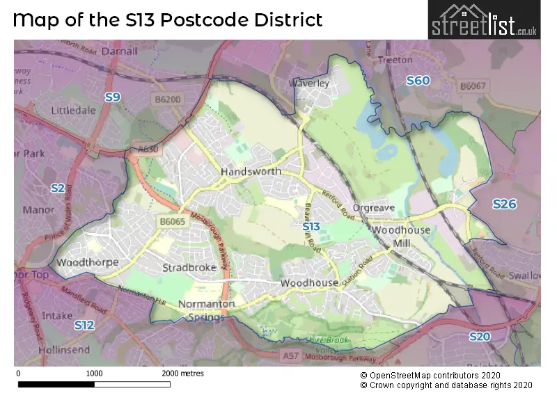
The S13 Postcode shares a border with S12 (SHEFFIELD, Ridgeway, Hackenthorpe), S2 (SHEFFIELD, Park Hill), S20 (Beighton, Halfway, Mosborough), S26 (Swallownest, Aston, Kiveton Park), S9 (SHEFFIELD, Tinsley) and S60 (ROTHERHAM, Brinsworth, Whiston).
The primary settlement in the S13 postcode district is Sheffield, located in the county of South Yorkshire, England. Other significant settlements in the district include Woodhouse and Handsworth. The post town for the S13 postcode district is also Sheffield.
For the district S13, we have data on 3 postcode sectors. Here's a breakdown: The sector S13 7, covers Sheffield and Woodhouse in South Yorkshire. The sector S13 8, covers Sheffield in South Yorkshire. The sector S13 9, covers Sheffield and Handsworth in South Yorkshire.

Map of the S13 Postcode District
Explore the S13 postcode district by using our free interactive map.
When it comes to local government, postal geography often disregards political borders. However, for a breakdown in the S13 District: the district mostly encompasses the Sheffield District (B) (569 postcodes), and finally, the Rotherham District (B) area (20 postcodes).
Recent House Sales in S13
| Date | Price | Address |
|---|---|---|
| 02/10/2023 | £131,000 | Sheffield Road, Woodhouse, Sheffield, S13 7EW |
| 29/09/2023 | £200,000 | Ravenscroft Avenue, Sheffield, S13 8PL |
| 27/09/2023 | £200,000 | Ravenscroft Crescent, Sheffield, S13 8PP |
| 25/09/2023 | £105,000 | Meetinghouse Lane, Woodhouse, Sheffield, S13 7PJ |
| 11/09/2023 | £132,500 | Doveholes Drive, Handsworth, Sheffield, S13 9DP |
| 01/09/2023 | £300,000 | Sundown Road, Sheffield, S13 8UD |
| 31/08/2023 | £140,000 | Wenlock Street, Sheffield, S13 8TS |
| 31/08/2023 | £120,000 | Stradbroke Drive, Sheffield, S13 8SD |
| 30/08/2023 | £186,000 | Driver Street, Sheffield, S13 9WQ |
| 30/08/2023 | £250,000 | Station Road, Woodhouse, Sheffield, S13 7QH |
Weather Forecast for S13
Press Button to Show Forecast for Handsworth (South Yorkshire)
| Time Period | Icon | Description | Temperature | Rain Probability | Wind |
|---|---|---|---|---|---|
| 18:00 to 21:00 | Cloudy | 8.0°C (feels like 5.0°C) | 6.00% | NE 7 mph | |
| 21:00 to 00:00 | Cloudy | 5.0°C (feels like 3.0°C) | 5.00% | ENE 7 mph |
Press Button to Show Forecast for Handsworth (South Yorkshire)
| Time Period | Icon | Description | Temperature | Rain Probability | Wind |
|---|---|---|---|---|---|
| 00:00 to 03:00 | Partly cloudy (night) | 3.0°C (feels like 2.0°C) | 1.00% | NE 4 mph | |
| 03:00 to 06:00 | Clear night | 2.0°C (feels like 0.0°C) | 1.00% | N 4 mph | |
| 06:00 to 09:00 | Sunny day | 3.0°C (feels like 0.0°C) | 1.00% | N 7 mph | |
| 09:00 to 12:00 | Cloudy | 6.0°C (feels like 4.0°C) | 4.00% | NE 7 mph | |
| 12:00 to 15:00 | Overcast | 8.0°C (feels like 7.0°C) | 9.00% | ENE 4 mph | |
| 15:00 to 18:00 | Cloudy | 9.0°C (feels like 8.0°C) | 7.00% | ENE 4 mph | |
| 18:00 to 21:00 | Cloudy | 8.0°C (feels like 5.0°C) | 8.00% | E 7 mph | |
| 21:00 to 00:00 | Partly cloudy (night) | 5.0°C (feels like 3.0°C) | 5.00% | ENE 7 mph |
Press Button to Show Forecast for Handsworth (South Yorkshire)
| Time Period | Icon | Description | Temperature | Rain Probability | Wind |
|---|---|---|---|---|---|
| 00:00 to 03:00 | Cloudy | 4.0°C (feels like 2.0°C) | 8.00% | NE 4 mph | |
| 03:00 to 06:00 | Cloudy | 3.0°C (feels like 1.0°C) | 12.00% | NE 7 mph | |
| 06:00 to 09:00 | Partly cloudy (day) | 4.0°C (feels like 1.0°C) | 8.00% | NE 7 mph | |
| 09:00 to 12:00 | Cloudy | 7.0°C (feels like 4.0°C) | 11.00% | ENE 9 mph | |
| 12:00 to 15:00 | Cloudy | 9.0°C (feels like 6.0°C) | 19.00% | ENE 9 mph | |
| 15:00 to 18:00 | Cloudy | 10.0°C (feels like 7.0°C) | 18.00% | ENE 11 mph | |
| 18:00 to 21:00 | Cloudy | 9.0°C (feels like 6.0°C) | 20.00% | ENE 11 mph | |
| 21:00 to 00:00 | Cloudy | 7.0°C (feels like 3.0°C) | 17.00% | NE 11 mph |
Press Button to Show Forecast for Handsworth (South Yorkshire)
| Time Period | Icon | Description | Temperature | Rain Probability | Wind |
|---|---|---|---|---|---|
| 00:00 to 03:00 | Light rain | 6.0°C (feels like 3.0°C) | 48.00% | NE 11 mph | |
| 03:00 to 06:00 | Light rain | 6.0°C (feels like 2.0°C) | 50.00% | NNE 13 mph | |
| 06:00 to 09:00 | Heavy rain | 6.0°C (feels like 3.0°C) | 78.00% | NNE 13 mph | |
| 09:00 to 12:00 | Light rain | 8.0°C (feels like 4.0°C) | 58.00% | NNE 13 mph | |
| 12:00 to 15:00 | Heavy rain shower (day) | 9.0°C (feels like 6.0°C) | 61.00% | NNE 13 mph | |
| 15:00 to 18:00 | Light rain | 10.0°C (feels like 7.0°C) | 51.00% | NE 11 mph | |
| 18:00 to 21:00 | Overcast | 9.0°C (feels like 7.0°C) | 22.00% | N 9 mph | |
| 21:00 to 00:00 | Partly cloudy (night) | 7.0°C (feels like 5.0°C) | 10.00% | SSE 7 mph |
Where is the S13 Postcode District?
The postcode district for S13 is located in Sheffield. It is situated in the South East of Rotherham, which is approximately 5.19 miles away. The nearest town in the South West direction is Dronfield, which is around 6.09 miles away. In the South, Chesterfield is the closest town, located approximately 9.42 miles from the postcode district. Worksop is the nearest town in the South East direction, at a distance of 11.75 miles. The town of Barnsley is situated in the North and is around 13.06 miles away. The distance from the postcode district to London is approximately 138.90 miles.
The district is within the post town of SHEFFIELD.
The sector has postcodes within the nation of England.
The S13 Postcode District is covers the following regions.
- Sheffield - South Yorkshire - Yorkshire and The Humber
- Barnsley, Doncaster and Rotherham - South Yorkshire - Yorkshire and The Humber
| Postcode Sector | Delivery Office |
|---|---|
| S13 7 | Sheffield Sepostal Delivery Office |
| S13 8 | Sheffield Sepostal Delivery Office |
| S13 9 | Sheffield Sepostal Delivery Office |
| S | 1 | 3 | - | X | X | X |
| S | 1 | 3 | Space | Numeric | Letter | Letter |
Current Monthly Rental Prices
| # Bedrooms | Min Price | Max Price | Avg Price |
|---|---|---|---|
| 1 | £475 | £725 | £600 |
| 2 | £795 | £1,100 | £905 |
| 3 | £800 | £1,400 | £1,025 |
Current House Prices
| # Bedrooms | Min Price | Max Price | Avg Price |
|---|---|---|---|
| 1 | £60,000 | £100,000 | £78,333 |
| 2 | £90,000 | £250,000 | £140,998 |
| 3 | £99,000 | £285,000 | £198,253 |
| 4 | £160,000 | £375,000 | £291,000 |
Estate Agents who Operate in the S13 District
| Logo | Name | Brand Name | Address | Contact Number | Total Properties |
|---|---|---|---|---|---|
 | Sheffield | 2Roost | 27 Main Street, Swallownest, Sheffield, S26 4TZ | 0114 287 8696 | 35 |
 | Gleadless | Blundells | 183 White Lane, Sheffield, S12 3GF | 0114 697 0809 | 17 |
 | Sheffield | Key2go Estate & Letting Agents Ltd | 38a High Street Mosborough Sheffield S20 5AE | 0114 697 1849 | 9 |
 | Yorkshire | Strike | Nationwide | 0113 519 9126 | 8 |
 | Crystal Peaks | Haybrook | 4 Peak Square, Crystal Peaks, S20 7PH | 0114 697 3219 | 7 |
| Type of Property | 2018 Average | 2018 Sales | 2017 Average | 2017 Sales | 2016 Average | 2016 Sales | 2015 Average | 2015 Sales |
|---|---|---|---|---|---|---|---|---|
| Detached | £218,143 | 69 | £210,810 | 29 | £207,159 | 41 | £186,391 | 41 |
| Semi-Detached | £141,411 | 270 | £125,576 | 231 | £125,708 | 221 | £120,973 | 206 |
| Terraced | £116,405 | 106 | £112,783 | 96 | £104,102 | 120 | £105,566 | 93 |
| Flats | £93,723 | 28 | £86,839 | 28 | £90,984 | 32 | £84,785 | 28 |