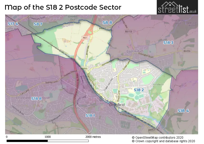
The S18 2 postcode sector stands on the Derbyshire and South Yorkshire border.
Did you know? According to the 2021 Census, the S18 2 postcode sector is home to a bustling 5,826 residents!
Given that each sector allows for 400 unique postcode combinations. Letters C, I, K, M, O and V are not allowed in the last two letters of a postcode. With 124 postcodes already in use, this leaves 276 units available.
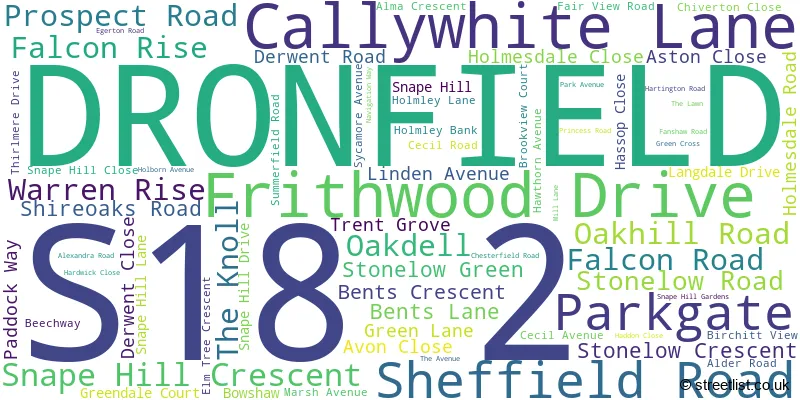
The S18 2 postal code covers the settlement of DRONFIELD.
The S18 2 Postcode shares a border with S17 4 (SHEFFIELD, Totley Rise, Bradway), S18 1 (DRONFIELD), S18 3 (Coal Aston), S18 8 (Dronfield Woodhouse), S8 7 (SHEFFIELD), S8 8 (SHEFFIELD) and S18 4 (Unstone, Apperknowle).
The sector is within the post town of DRONFIELD.
S18 2 is a postcode sector within the S18 postcode district which is within the S Sheffield postcode area.
The Royal Mail delivery office for the S18 2 postal sector is the Dronfield Delivery Office.
The area of the S18 2 postcode sector is 1.49 square miles which is 3.85 square kilometres or 951.62 square acres.
Waterways within the S18 2 postcode sector include the River Drone.

Map of the S18 2 Postcode Sector
Explore the S18 2 postcode sector by using our free interactive map.
| S | 1 | 8 | - | 2 | X | X |
| S | 1 | 8 | Space | 2 | Letter | Letter |
Official List of Streets
DRONFIELD (67 Streets)
Unofficial Streets or Alternative Spellings
DRONFIELD
GREENDALE COURT HALLOWES LANE LEA ROAD SOAPER LANE STUBLEY HOLLOW WREAKES LANECoal Aston
FERNDALE CLOSE FERNDALE ROAD HOLMLEY LANEUnstone
CHESTERFIELD ROADSHEFFIELD
CHESTERFIELD ROAD SOUTH JORDANTHORPE PARKWAYWeather Forecast for S18 2
Press Button to Show Forecast for Dronfield
| Time Period | Icon | Description | Temperature | Rain Probability | Wind |
|---|---|---|---|---|---|
| 03:00 to 06:00 | Cloudy | 4.0°C (feels like 1.0°C) | 4.00% | WSW 7 mph | |
| 06:00 to 09:00 | Cloudy | 4.0°C (feels like 2.0°C) | 4.00% | WSW 7 mph | |
| 09:00 to 12:00 | Overcast | 7.0°C (feels like 4.0°C) | 16.00% | NW 9 mph | |
| 12:00 to 15:00 | Light rain | 6.0°C (feels like 4.0°C) | 48.00% | N 9 mph | |
| 15:00 to 18:00 | Cloudy | 8.0°C (feels like 7.0°C) | 8.00% | N 4 mph | |
| 18:00 to 21:00 | Cloudy | 7.0°C (feels like 5.0°C) | 6.00% | NE 7 mph | |
| 21:00 to 00:00 | Cloudy | 5.0°C (feels like 3.0°C) | 8.00% | NNE 4 mph |
Press Button to Show Forecast for Dronfield
| Time Period | Icon | Description | Temperature | Rain Probability | Wind |
|---|---|---|---|---|---|
| 00:00 to 03:00 | Cloudy | 3.0°C (feels like 1.0°C) | 4.00% | NE 4 mph | |
| 03:00 to 06:00 | Partly cloudy (night) | 2.0°C (feels like 0.0°C) | 1.00% | NNE 4 mph | |
| 06:00 to 09:00 | Sunny day | 2.0°C (feels like 0.0°C) | 1.00% | N 4 mph | |
| 09:00 to 12:00 | Partly cloudy (day) | 6.0°C (feels like 4.0°C) | 2.00% | NE 7 mph | |
| 12:00 to 15:00 | Overcast | 8.0°C (feels like 7.0°C) | 9.00% | ENE 4 mph | |
| 15:00 to 18:00 | Cloudy | 9.0°C (feels like 8.0°C) | 9.00% | ENE 4 mph | |
| 18:00 to 21:00 | Cloudy | 8.0°C (feels like 5.0°C) | 8.00% | E 7 mph | |
| 21:00 to 00:00 | Cloudy | 5.0°C (feels like 3.0°C) | 8.00% | ENE 7 mph |
Press Button to Show Forecast for Dronfield
| Time Period | Icon | Description | Temperature | Rain Probability | Wind |
|---|---|---|---|---|---|
| 00:00 to 03:00 | Cloudy | 3.0°C (feels like 1.0°C) | 8.00% | NE 4 mph | |
| 03:00 to 06:00 | Cloudy | 3.0°C (feels like 1.0°C) | 11.00% | NE 4 mph | |
| 06:00 to 09:00 | Partly cloudy (day) | 4.0°C (feels like 1.0°C) | 8.00% | NE 7 mph | |
| 09:00 to 12:00 | Cloudy | 7.0°C (feels like 4.0°C) | 11.00% | ENE 9 mph | |
| 12:00 to 15:00 | Cloudy | 9.0°C (feels like 6.0°C) | 19.00% | ENE 9 mph | |
| 15:00 to 18:00 | Overcast | 10.0°C (feels like 7.0°C) | 21.00% | ENE 11 mph | |
| 18:00 to 21:00 | Cloudy | 9.0°C (feels like 6.0°C) | 19.00% | ENE 11 mph | |
| 21:00 to 00:00 | Cloudy | 7.0°C (feels like 3.0°C) | 17.00% | NE 11 mph |
Press Button to Show Forecast for Dronfield
| Time Period | Icon | Description | Temperature | Rain Probability | Wind |
|---|---|---|---|---|---|
| 00:00 to 03:00 | Light rain | 6.0°C (feels like 3.0°C) | 48.00% | NE 11 mph | |
| 03:00 to 06:00 | Light rain | 6.0°C (feels like 2.0°C) | 50.00% | NNE 13 mph | |
| 06:00 to 09:00 | Heavy rain | 6.0°C (feels like 3.0°C) | 79.00% | NNE 13 mph | |
| 09:00 to 12:00 | Light rain | 8.0°C (feels like 4.0°C) | 57.00% | NNE 13 mph | |
| 12:00 to 15:00 | Light rain shower (day) | 9.0°C (feels like 6.0°C) | 46.00% | NNE 13 mph | |
| 15:00 to 18:00 | Light rain | 9.0°C (feels like 7.0°C) | 52.00% | NE 11 mph | |
| 18:00 to 21:00 | Overcast | 9.0°C (feels like 7.0°C) | 21.00% | N 9 mph | |
| 21:00 to 00:00 | Partly cloudy (night) | 7.0°C (feels like 5.0°C) | 10.00% | SSE 7 mph |
Schools and Places of Education Within the S18 2 Postcode Sector
Dronfield Henry Fanshawe School
Voluntary controlled school
Green Lane, Dronfield, Derbyshire, S18 2FZ
Head: Mr Martyn Cooper
Ofsted Rating: Good
Inspection: 2023-07-12 (288 days ago)
Website: Visit Dronfield Henry Fanshawe School Website
Phone: 01246412372
Number of Pupils: 1868
Dronfield Stonelow Junior School
Community school
Stonelow Road, Dronfield, Derbyshire, S18 2EP
Head: Mrs Catherine Robinson
Ofsted Rating: Good
Inspection: 2023-12-14 (133 days ago)
Website: Visit Dronfield Stonelow Junior School Website
Phone: 01246414370
Number of Pupils: 147
Holmesdale Infant School
Community school
The Avenue, Dronfield, Derbyshire, S18 2LR
Head: Mrs S Lockwood
Ofsted Rating: Outstanding
Inspection: 2013-07-03 (3949 days ago)
Website: Visit Holmesdale Infant School Website
Phone: 01246413284
Number of Pupils: 147
Lenthall Infant and Nursery School
Community school
Marsh Avenue, Dronfield, Derbyshire, S18 2HB
Head: Mrs Kerry Moody
Ofsted Rating: Good
Inspection: 2023-10-12 (196 days ago)
Website: Visit Lenthall Infant and Nursery School Website
Phone: 01246414569
Number of Pupils: 74
Northfield Junior School
Community school
Falcon Road, Dronfield, Derbyshire, S18 2ED
Head: Mrs Rebecca Timperley
Ofsted Rating: Good
Inspection: 2018-10-09 (2025 days ago)
Website: Visit Northfield Junior School Website
Phone: 01246413134
Number of Pupils: 177
House Prices in the S18 2 Postcode Sector
| Type of Property | 2018 Average | 2018 Sales | 2017 Average | 2017 Sales | 2016 Average | 2016 Sales | 2015 Average | 2015 Sales |
|---|---|---|---|---|---|---|---|---|
| Detached | £250,839 | 28 | £270,797 | 33 | £220,403 | 31 | £213,185 | 30 |
| Semi-Detached | £215,575 | 36 | £205,907 | 42 | £191,220 | 28 | £178,874 | 32 |
| Terraced | £175,525 | 18 | £176,368 | 11 | £176,564 | 7 | £156,492 | 18 |
| Flats | £122,531 | 8 | £108,667 | 9 | £118,125 | 8 | £134,250 | 7 |
Important Postcodes S18 2 in the Postcode Sector
S18 2ED is the postcode for Northfield Junior School, Falcon Road
S18 2EJ is the postcode for BLOCK 1, Gladys Buxton Adult Education Centre, Oakhill Road, Oakhill Medical Practice, Oakhill Road, BLOCK 2, Gladys Buxton Adult Education Centre, Oakhill Road, and Gladys Buxton Adult Education Centre, Oakhill Road
S18 2EP is the postcode for Stonelow Junior School, Stonelow Road
S18 2FZ is the postcode for BLOCK F, Dronfield Henry Fanshawe School, Green Lane, BLOCK A, Dronfield Henry Fanshawe School, Green Lane, BLOCK D, Dronfield Henry Fanshawe School, Green Lane, BLOCK B & C, Dronfield Henry Fanshawe School, Green Lane, and Dronfield Henry Fanshawe School, Green Lane
S18 2HB is the postcode for Lenthall Infant & Nursery School, Marsh Avenue
S18 2LR is the postcode for Homesdale Infant School, 27 The Avenue
S18 2XP is the postcode for Gosforth Lodge, Callywhite Lane
| The S18 2 Sector is within these Local Authorities |
|
|---|---|
| The S18 2 Sector is within these Counties |
|
| The S18 2 Sector is within these Water Company Areas |
|