The S18 4 postcode sector is within the county of Derbyshire.
Did you know? According to the 2021 Census, the S18 4 postcode sector is home to a bustling 1,684 residents!
Given that each sector allows for 400 unique postcode combinations. Letters C, I, K, M, O and V are not allowed in the last two letters of a postcode. With 51 postcodes already in use, this leaves 349 units available.
The largest settlements in the S18 4 postal code are Unstone and Apperknowle.
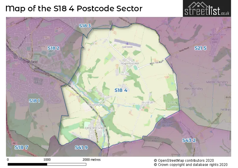
The S18 4 Postcode shares a border with S18 1 (DRONFIELD), S18 3 (Coal Aston), S21 5 (Marsh Lane, Middle Handley, Nether Handley), S18 2 (DRONFIELD), S41 9 (Old Whittington, CHESTERFIELD, Whittington Moor) and S43 2 (New Whittington, Hollingwood, Barrow Hill).
The sector is within the post town of DRONFIELD.
S18 4 is a postcode sector within the S18 postcode district which is within the S Sheffield postcode area.
The Royal Mail delivery office for the S18 4 postal sector is the Dronfield Delivery Office.
The area of the S18 4 postcode sector is 2.78 square miles which is 7.21 square kilometres or 1,781.03 square acres.
Waterways within the S18 4 postcode sector include the River Drone.

Map of the S18 4 Postcode Sector
Explore the S18 4 postcode sector by using our free interactive map.
| S | 1 | 8 | - | 4 | X | X |
| S | 1 | 8 | Space | 4 | Letter | Letter |
Official List of Streets
Unstone (24 Streets)
Apperknowle (20 Streets)
Unofficial Streets or Alternative Spellings
Marsh Lane
MAIN ROAD SNOWDON LANECoal Aston
ECKINGTON ROADCHESTERFIELD
HUNDALL LANEWeather Forecast for S18 4
Press Button to Show Forecast for Dronfield
| Time Period | Icon | Description | Temperature | Rain Probability | Wind |
|---|---|---|---|---|---|
| 18:00 to 21:00 | Cloudy | 7.0°C (feels like 5.0°C) | 6.00% | NE 7 mph | |
| 21:00 to 00:00 | Cloudy | 5.0°C (feels like 3.0°C) | 8.00% | NNE 4 mph |
Press Button to Show Forecast for Dronfield
| Time Period | Icon | Description | Temperature | Rain Probability | Wind |
|---|---|---|---|---|---|
| 00:00 to 03:00 | Cloudy | 3.0°C (feels like 1.0°C) | 4.00% | NE 4 mph | |
| 03:00 to 06:00 | Partly cloudy (night) | 2.0°C (feels like 0.0°C) | 1.00% | NNE 4 mph | |
| 06:00 to 09:00 | Sunny day | 2.0°C (feels like 0.0°C) | 1.00% | N 4 mph | |
| 09:00 to 12:00 | Partly cloudy (day) | 6.0°C (feels like 4.0°C) | 2.00% | NE 7 mph | |
| 12:00 to 15:00 | Overcast | 8.0°C (feels like 7.0°C) | 9.00% | ENE 4 mph | |
| 15:00 to 18:00 | Cloudy | 9.0°C (feels like 8.0°C) | 9.00% | ENE 4 mph | |
| 18:00 to 21:00 | Cloudy | 8.0°C (feels like 5.0°C) | 8.00% | E 7 mph | |
| 21:00 to 00:00 | Cloudy | 5.0°C (feels like 3.0°C) | 8.00% | ENE 7 mph |
Press Button to Show Forecast for Dronfield
| Time Period | Icon | Description | Temperature | Rain Probability | Wind |
|---|---|---|---|---|---|
| 00:00 to 03:00 | Cloudy | 3.0°C (feels like 1.0°C) | 8.00% | NE 4 mph | |
| 03:00 to 06:00 | Cloudy | 3.0°C (feels like 1.0°C) | 11.00% | NE 4 mph | |
| 06:00 to 09:00 | Partly cloudy (day) | 4.0°C (feels like 1.0°C) | 8.00% | NE 7 mph | |
| 09:00 to 12:00 | Cloudy | 7.0°C (feels like 4.0°C) | 11.00% | ENE 9 mph | |
| 12:00 to 15:00 | Cloudy | 9.0°C (feels like 6.0°C) | 19.00% | ENE 9 mph | |
| 15:00 to 18:00 | Overcast | 10.0°C (feels like 7.0°C) | 21.00% | ENE 11 mph | |
| 18:00 to 21:00 | Cloudy | 9.0°C (feels like 6.0°C) | 19.00% | ENE 11 mph | |
| 21:00 to 00:00 | Cloudy | 7.0°C (feels like 3.0°C) | 17.00% | NE 11 mph |
Press Button to Show Forecast for Dronfield
| Time Period | Icon | Description | Temperature | Rain Probability | Wind |
|---|---|---|---|---|---|
| 00:00 to 03:00 | Light rain | 6.0°C (feels like 3.0°C) | 48.00% | NE 11 mph | |
| 03:00 to 06:00 | Light rain | 6.0°C (feels like 2.0°C) | 50.00% | NNE 13 mph | |
| 06:00 to 09:00 | Heavy rain | 6.0°C (feels like 3.0°C) | 79.00% | NNE 13 mph | |
| 09:00 to 12:00 | Light rain | 8.0°C (feels like 4.0°C) | 57.00% | NNE 13 mph | |
| 12:00 to 15:00 | Light rain shower (day) | 9.0°C (feels like 6.0°C) | 46.00% | NNE 13 mph | |
| 15:00 to 18:00 | Light rain | 9.0°C (feels like 7.0°C) | 52.00% | NE 11 mph | |
| 18:00 to 21:00 | Overcast | 9.0°C (feels like 7.0°C) | 21.00% | N 9 mph | |
| 21:00 to 00:00 | Partly cloudy (night) | 7.0°C (feels like 5.0°C) | 10.00% | SSE 7 mph |
Schools and Places of Education Within the S18 4 Postcode Sector
Unstone Junior School
Community school
Main Road, Dronfield, Derbyshire, S18 4AB
Head: Mrs Rachael Fowlds
Ofsted Rating: Good
Inspection: 2021-11-24 (883 days ago)
Website: Visit Unstone Junior School Website
Phone: 01246413109
Number of Pupils: 49
Unstone St Mary's Infant School
Community school
Crow Lane, Dronfield, Derbyshire, S18 4AL
Head: Mrs Rachael Fowlds
Ofsted Rating: Requires improvement
Inspection: 2020-02-12 (1534 days ago)
Website: Visit Unstone St Mary's Infant School Website
Phone: 01246412096
Number of Pupils: 42
House Prices in the S18 4 Postcode Sector
| Type of Property | 2018 Average | 2018 Sales | 2017 Average | 2017 Sales | 2016 Average | 2016 Sales | 2015 Average | 2015 Sales |
|---|---|---|---|---|---|---|---|---|
| Detached | £482,500 | 6 | £371,107 | 7 | £338,167 | 6 | £324,493 | 7 |
| Semi-Detached | £170,190 | 5 | £155,020 | 5 | £146,857 | 9 | £211,250 | 4 |
| Terraced | £130,250 | 4 | £133,333 | 3 | £199,006 | 3 | £134,625 | 6 |
| Flats | £0 | 0 | £105,000 | 1 | £0 | 0 | £0 | 0 |
Important Postcodes S18 4 in the Postcode Sector
S18 4AB is the postcode for Unstone Junior School, Main Road
| The S18 4 Sector is within these Local Authorities |
|
|---|---|
| The S18 4 Sector is within these Counties |
|
| The S18 4 Sector is within these Water Company Areas |
|