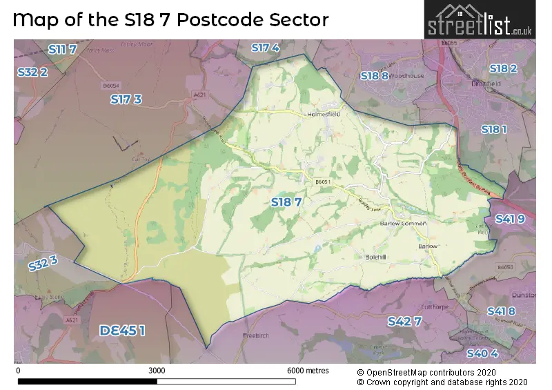
The S18 7 postcode sector stands on the Derbyshire and South Yorkshire border.
Did you know? According to the 2021 Census, the S18 7 postcode sector is home to a bustling 1,943 residents!
Given that each sector allows for 400 unique postcode combinations. Letters C, I, K, M, O and V are not allowed in the last two letters of a postcode. With 58 postcodes already in use, this leaves 342 units available.
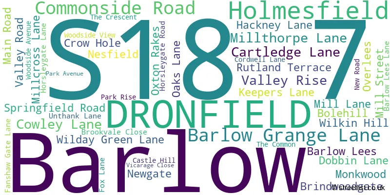
The largest settlement in the S18 7 postal code is Barlow followed by Holmesfield, and DRONFIELD.
The S18 7 Postcode shares a border with S17 4 (SHEFFIELD, Totley Rise, Bradway), S18 1 (DRONFIELD), S18 8 (Dronfield Woodhouse), DE45 1 (BAKEWELL, Youlgrave, Baslow), S17 3 (SHEFFIELD, Dore, Totley Rise), S32 3 (Calver), S41 9 (Old Whittington, CHESTERFIELD, Whittington Moor) and S42 7 (Holymoorside, Walton, Ashgate).
The sector is within the post town of DRONFIELD.
S18 7 is a postcode sector within the S18 postcode district which is within the S Sheffield postcode area.
The Royal Mail delivery office for the S18 7 postal sector is the Dronfield Delivery Office.
The area of the S18 7 postcode sector is 12.48 square miles which is 32.32 square kilometres or 7,986.13 square acres.
Waterways within the S18 7 postcode sector include the Barlow Brook, Bar Brook, Millthorpe Brook, Blake Brook, Blackleach Brook, Pingle Dike, Sud Brook.

Map of the S18 7 Postcode Sector
Explore the S18 7 postcode sector by using our free interactive map.
| S | 1 | 8 | - | 7 | X | X |
| S | 1 | 8 | Space | 7 | Letter | Letter |
Official List of Streets
Barlow (26 Streets)
DRONFIELD (1 Streets)
Holmesfield (20 Streets)
Unofficial Streets or Alternative Spellings
CHESTERFIELD
BARLOW ROADDronfield Woodhouse
HOLMESFIELD ROADWeather Forecast for S18 7
Press Button to Show Forecast for Dronfield Woodhouse
| Time Period | Icon | Description | Temperature | Rain Probability | Wind |
|---|---|---|---|---|---|
| 06:00 to 09:00 | Overcast | 5.0°C (feels like 1.0°C) | 9.00% | N 9 mph | |
| 09:00 to 12:00 | Cloudy | 6.0°C (feels like 3.0°C) | 7.00% | N 13 mph | |
| 12:00 to 15:00 | Partly cloudy (day) | 9.0°C (feels like 6.0°C) | 1.00% | N 11 mph | |
| 15:00 to 18:00 | Cloudy | 10.0°C (feels like 7.0°C) | 3.00% | N 11 mph | |
| 18:00 to 21:00 | Cloudy | 8.0°C (feels like 6.0°C) | 7.00% | NNE 9 mph | |
| 21:00 to 00:00 | Cloudy | 6.0°C (feels like 4.0°C) | 8.00% | N 9 mph |
Press Button to Show Forecast for Dronfield Woodhouse
| Time Period | Icon | Description | Temperature | Rain Probability | Wind |
|---|---|---|---|---|---|
| 00:00 to 03:00 | Cloudy | 5.0°C (feels like 2.0°C) | 5.00% | N 9 mph | |
| 03:00 to 06:00 | Cloudy | 4.0°C (feels like 1.0°C) | 5.00% | N 7 mph | |
| 06:00 to 09:00 | Cloudy | 4.0°C (feels like 0.0°C) | 5.00% | NNW 9 mph | |
| 09:00 to 12:00 | Overcast | 5.0°C (feels like 2.0°C) | 9.00% | N 11 mph | |
| 12:00 to 15:00 | Overcast | 7.0°C (feels like 4.0°C) | 8.00% | N 11 mph | |
| 15:00 to 18:00 | Overcast | 8.0°C (feels like 4.0°C) | 9.00% | N 11 mph | |
| 18:00 to 21:00 | Cloudy | 6.0°C (feels like 3.0°C) | 6.00% | NNE 11 mph | |
| 21:00 to 00:00 | Cloudy | 4.0°C (feels like 1.0°C) | 5.00% | NNE 7 mph |
Press Button to Show Forecast for Dronfield Woodhouse
| Time Period | Icon | Description | Temperature | Rain Probability | Wind |
|---|---|---|---|---|---|
| 00:00 to 03:00 | Partly cloudy (night) | 3.0°C (feels like 0.0°C) | 2.00% | NNW 7 mph | |
| 03:00 to 06:00 | Cloudy | 3.0°C (feels like 0.0°C) | 4.00% | NW 7 mph | |
| 06:00 to 09:00 | Cloudy | 3.0°C (feels like 0.0°C) | 5.00% | NNW 7 mph | |
| 09:00 to 12:00 | Cloudy | 6.0°C (feels like 3.0°C) | 6.00% | N 9 mph | |
| 12:00 to 15:00 | Overcast | 8.0°C (feels like 5.0°C) | 10.00% | N 9 mph | |
| 15:00 to 18:00 | Cloudy | 8.0°C (feels like 6.0°C) | 10.00% | NNW 7 mph | |
| 18:00 to 21:00 | Cloudy | 8.0°C (feels like 6.0°C) | 9.00% | NNW 7 mph | |
| 21:00 to 00:00 | Cloudy | 6.0°C (feels like 4.0°C) | 6.00% | NNW 4 mph |
Press Button to Show Forecast for Dronfield Woodhouse
| Time Period | Icon | Description | Temperature | Rain Probability | Wind |
|---|---|---|---|---|---|
| 00:00 to 03:00 | Cloudy | 4.0°C (feels like 3.0°C) | 5.00% | NNW 4 mph | |
| 03:00 to 06:00 | Cloudy | 4.0°C (feels like 2.0°C) | 7.00% | NNW 4 mph | |
| 06:00 to 09:00 | Cloudy | 4.0°C (feels like 3.0°C) | 8.00% | W 4 mph | |
| 09:00 to 12:00 | Cloudy | 7.0°C (feels like 5.0°C) | 7.00% | NNW 7 mph | |
| 12:00 to 15:00 | Overcast | 9.0°C (feels like 7.0°C) | 14.00% | NNW 7 mph | |
| 15:00 to 18:00 | Overcast | 9.0°C (feels like 7.0°C) | 14.00% | SSE 7 mph | |
| 18:00 to 21:00 | Cloudy | 9.0°C (feels like 7.0°C) | 18.00% | SE 7 mph | |
| 21:00 to 00:00 | Cloudy | 6.0°C (feels like 5.0°C) | 10.00% | SSE 7 mph |
Schools and Places of Education Within the S18 7 Postcode Sector
Barlow CofE Primary School
Voluntary controlled school
Millcross Lane, Dronfield, Derbyshire, S18 7TA
Head: Mrs Penny Watkin
Ofsted Rating: Good
Inspection: 2018-09-19 (2043 days ago)
Website: Visit Barlow CofE Primary School Website
Phone: 01142890413
Number of Pupils: 85
Penny Acres Primary School
Community school
The Common, Dronfield, Derbyshire, S18 7WP
Head: Mr David Ratcliffe(Executive)
Ofsted Rating: Good
Inspection: 2023-07-04 (294 days ago)
Website: Visit Penny Acres Primary School Website
Phone: 01142890330
Number of Pupils: 55
House Prices in the S18 7 Postcode Sector
| Type of Property | 2018 Average | 2018 Sales | 2017 Average | 2017 Sales | 2016 Average | 2016 Sales | 2015 Average | 2015 Sales |
|---|---|---|---|---|---|---|---|---|
| Detached | £413,950 | 10 | £527,969 | 16 | £483,900 | 10 | £463,417 | 6 |
| Semi-Detached | £277,239 | 8 | £183,000 | 1 | £156,250 | 2 | £261,000 | 4 |
| Terraced | £222,000 | 6 | £343,585 | 2 | £0 | 0 | £157,575 | 6 |
| Flats | £0 | 0 | £0 | 0 | £0 | 0 | £0 | 0 |
Important Postcodes S18 7 in the Postcode Sector
S18 7TA is the postcode for Barlow C of E Voluntary Controlled Primary School, Millcross Lane
| The S18 7 Sector is within these Local Authorities |
|
|---|---|
| The S18 7 Sector is within these Counties |
|
| The S18 7 Sector is within these Water Company Areas |
|