The S21 4 postcode sector stands on the Derbyshire and South Yorkshire border.
Did you know? According to the 2021 Census, the S21 4 postcode sector is home to a bustling 7,435 residents!
Given that each sector allows for 400 unique postcode combinations. Letters C, I, K, M, O and V are not allowed in the last two letters of a postcode. With 168 postcodes already in use, this leaves 232 units available.
The S21 4 postal code covers the settlement of Eckington.
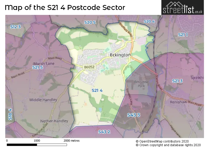
The S21 4 Postcode shares a border with S43 3 (Staveley, Inkersall, Mastin Moor), S20 4 (Halfway), S21 3 (Renishaw, Spinkhill), S21 5 (Marsh Lane, Middle Handley, Nether Handley), S20 5 (Mosborough), S21 1 (Killamarsh) and S43 2 (New Whittington, Hollingwood, Barrow Hill).
The sector is within the post town of SHEFFIELD.
S21 4 is a postcode sector within the S21 postcode district which is within the S Sheffield postcode area.
The Royal Mail delivery office for the S21 4 postal sector is the Halfway Delivery Office.
The area of the S21 4 postcode sector is 2.79 square miles which is 7.22 square kilometres or 1,784.11 square acres.
Waterways within the S21 4 postcode sector include the The Moss, River Rother.

Map of the S21 4 Postcode Sector
Explore the S21 4 postcode sector by using our free interactive map.
| S | 2 | 1 | - | 4 | X | X |
| S | 2 | 1 | Space | 4 | Letter | Letter |
Official List of Streets
Eckington (124 Streets)
Unofficial Streets or Alternative Spellings
Weather Forecast for S21 4
Press Button to Show Forecast for Renishaw Hall & Gardens
| Time Period | Icon | Description | Temperature | Rain Probability | Wind |
|---|---|---|---|---|---|
| 15:00 to 18:00 | Cloudy | 9.0°C (feels like 7.0°C) | 9.00% | NNW 4 mph | |
| 18:00 to 21:00 | Cloudy | 8.0°C (feels like 6.0°C) | 9.00% | NE 4 mph | |
| 21:00 to 00:00 | Cloudy | 5.0°C (feels like 3.0°C) | 8.00% | ENE 4 mph |
Press Button to Show Forecast for Renishaw Hall & Gardens
| Time Period | Icon | Description | Temperature | Rain Probability | Wind |
|---|---|---|---|---|---|
| 00:00 to 03:00 | Cloudy | 3.0°C (feels like 1.0°C) | 5.00% | NNE 4 mph | |
| 03:00 to 06:00 | Clear night | 1.0°C (feels like -1.0°C) | 1.00% | N 2 mph | |
| 06:00 to 09:00 | Sunny day | 2.0°C (feels like 0.0°C) | 1.00% | N 4 mph | |
| 09:00 to 12:00 | Cloudy | 6.0°C (feels like 4.0°C) | 6.00% | NE 7 mph | |
| 12:00 to 15:00 | Overcast | 8.0°C (feels like 8.0°C) | 9.00% | ENE 4 mph | |
| 15:00 to 18:00 | Cloudy | 9.0°C (feels like 8.0°C) | 8.00% | ENE 4 mph | |
| 18:00 to 21:00 | Cloudy | 7.0°C (feels like 5.0°C) | 8.00% | ENE 7 mph | |
| 21:00 to 00:00 | Cloudy | 5.0°C (feels like 4.0°C) | 10.00% | E 4 mph |
Press Button to Show Forecast for Renishaw Hall & Gardens
| Time Period | Icon | Description | Temperature | Rain Probability | Wind |
|---|---|---|---|---|---|
| 00:00 to 03:00 | Cloudy | 4.0°C (feels like 3.0°C) | 8.00% | NNE 4 mph | |
| 03:00 to 06:00 | Cloudy | 3.0°C (feels like 1.0°C) | 12.00% | NNE 4 mph | |
| 06:00 to 09:00 | Partly cloudy (day) | 4.0°C (feels like 2.0°C) | 8.00% | NNE 4 mph | |
| 09:00 to 12:00 | Cloudy | 8.0°C (feels like 5.0°C) | 11.00% | ENE 9 mph | |
| 12:00 to 15:00 | Cloudy | 9.0°C (feels like 7.0°C) | 17.00% | E 9 mph | |
| 15:00 to 18:00 | Cloudy | 10.0°C (feels like 8.0°C) | 18.00% | ENE 9 mph | |
| 18:00 to 21:00 | Cloudy | 9.0°C (feels like 6.0°C) | 20.00% | ENE 11 mph | |
| 21:00 to 00:00 | Cloudy | 7.0°C (feels like 4.0°C) | 17.00% | NE 9 mph |
Press Button to Show Forecast for Renishaw Hall & Gardens
| Time Period | Icon | Description | Temperature | Rain Probability | Wind |
|---|---|---|---|---|---|
| 00:00 to 03:00 | Light rain | 6.0°C (feels like 3.0°C) | 48.00% | NE 11 mph | |
| 03:00 to 06:00 | Light rain | 6.0°C (feels like 3.0°C) | 50.00% | NNE 11 mph | |
| 06:00 to 09:00 | Heavy rain | 7.0°C (feels like 3.0°C) | 79.00% | NNE 13 mph | |
| 09:00 to 12:00 | Heavy rain | 8.0°C (feels like 5.0°C) | 79.00% | NNE 11 mph | |
| 12:00 to 15:00 | Heavy rain | 9.0°C (feels like 6.0°C) | 78.00% | N 11 mph | |
| 15:00 to 18:00 | Light rain | 10.0°C (feels like 7.0°C) | 54.00% | NNE 11 mph | |
| 18:00 to 21:00 | Overcast | 9.0°C (feels like 7.0°C) | 22.00% | N 9 mph | |
| 21:00 to 00:00 | Partly cloudy (night) | 7.0°C (feels like 6.0°C) | 9.00% | SSE 7 mph |
Schools and Places of Education Within the S21 4 Postcode Sector
Birk Hill Infant & Nursery School
Community school
Chestnut Avenue, Eckington, Derbyshire, S21 4BE
Head: Mrs Sue Birch
Ofsted Rating: Requires improvement
Inspection: 2023-09-14 (224 days ago)
Website: Visit Birk Hill Infant & Nursery School Website
Phone: 01246433205
Number of Pupils: 110
Camms CofE (Aided) Primary School
Voluntary aided school
Camms Close, Chesterfield, South Yorkshire, S21 4AU
Head: Mr Tim Cocking
Ofsted Rating: Good
Inspection: 2019-01-31 (1911 days ago)
Website: Visit Camms CofE (Aided) Primary School Website
Phone: 01246432829
Number of Pupils: 224
Eckington Junior School
Academy converter
School Street, Sheffield, Derbyshire, S21 4FL
Head: Ms Yvette Cherry
Ofsted Rating: Requires improvement
Inspection: 2020-02-05 (1541 days ago)
Website: Visit Eckington Junior School Website
Phone: 01246432549
Number of Pupils: 144
Landmarks
Special post 16 institution
Littlemoor House, Sheffield, South Yorkshire, S21 4EF
Head: Mr Lawrence Brocklesby
Ofsted Rating: Good
Inspection: 2018-06-14 (2142 days ago)
Website: Visit Landmarks Website
Phone: 01246433788
Number of Pupils: 0
House Prices in the S21 4 Postcode Sector
| Type of Property | 2018 Average | 2018 Sales | 2017 Average | 2017 Sales | 2016 Average | 2016 Sales | 2015 Average | 2015 Sales |
|---|---|---|---|---|---|---|---|---|
| Detached | £252,852 | 41 | £242,868 | 34 | £212,809 | 34 | £218,052 | 28 |
| Semi-Detached | £153,750 | 22 | £144,244 | 40 | £133,624 | 38 | £122,320 | 25 |
| Terraced | £121,306 | 32 | £101,300 | 25 | £110,250 | 28 | £101,819 | 29 |
| Flats | £93,130 | 5 | £97,075 | 6 | £94,636 | 7 | £58,575 | 6 |
Important Postcodes S21 4 in the Postcode Sector
S21 4AU is the postcode for Main Building, Eckington Camms C of E Voluntary Aided Primary School, Camms Close, Main Building, Eckington Camms Endowed C of E Primary School, Camms Close, and Eckington Camms C of E Voluntary Aided Primary School, Camms Close
S21 4AY is the postcode for East Midlands Ambulance Service NHS Trust, Ambulance Station, Castle Hill
S21 4BE is the postcode for Birk Hill Infant School, Chestnut Avenue, and BIRK HILL INFANT SCHOOL, CHESTNUT AVENUE, ECKINGTON
S21 4BZ is the postcode for ECKINGTON HEALTH CENTRE,, GOSBER ROAD,, ECKINGTON,, Moss Valley Medical Practice, Gosber Road, and Eckington Health Centre, Gosber Road
S21 4DA is the postcode for Eckington Swimming Pool, Gosber Street, and ECKINGTON SWIMMING POOL, GOSBER STREET, ECKINGTON
S21 4FL is the postcode for MAIN BLOCK, Eckington Junior School, School Street, MAIN BUILDING, Eckington Junior School, School Street, and Eckington Junior School, School Street
S21 4FT is the postcode for Northeast Derbyshire Family Support Centre, The Grange House, 88 Southgate, The Grange HOP, 88 Southgate, Whole Building, The Grange Family Support Centre, The Grange House, 88 Southgate, and The Main Building, The Grange HOP, 88 Southgate
S21 4GN is the postcode for BUILDING 1, Eckington School, Dronfield Road, GYMNASIUM BUILDING, Eckington School, Dronfield Road, BUILDING 4, Eckington School, Dronfield Road, and BUILDING 2, Eckington School, Dronfield Road
S21 4JG is the postcode for Derbyshire County Council, Eckington Library, Market Street
| The S21 4 Sector is within these Local Authorities |
|
|---|---|
| The S21 4 Sector is within these Counties |
|
| The S21 4 Sector is within these Water Company Areas |
|