The S26 5 postcode sector stands on the South Yorkshire and Derbyshire border.
Did you know? According to the 2021 Census, the S26 5 postcode sector is home to a bustling 3,878 residents!
Given that each sector allows for 400 unique postcode combinations. Letters C, I, K, M, O and V are not allowed in the last two letters of a postcode. With 73 postcodes already in use, this leaves 327 units available.
The largest settlement in the S26 5 postal code is Kiveton Park followed by Wales, and Wales Bar.
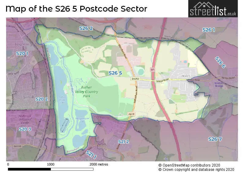
The S26 5 Postcode shares a border with S20 1 (Beighton), S20 2 (Sothall), S20 3 (Holbrook, Halfway), S26 1 (Todwick), S26 2 (Aston), S21 1 (Killamarsh), S21 2 (Killamarsh), S26 6 (Kiveton Park, Kiveton Park Station) and S26 7 (Harthill).
The sector is within the post town of SHEFFIELD.
S26 5 is a postcode sector within the S26 postcode district which is within the S Sheffield postcode area.
The Royal Mail delivery office for the S26 5 postal sector is the Dinnington Delivery Office.
The area of the S26 5 postcode sector is 2.95 square miles which is 7.64 square kilometres or 1,888.20 square acres.
The S26 5 postcode sector is crossed by the M1 motorway.
Waterways within the S26 5 postcode sector include the River Rother.

Map of the S26 5 Postcode Sector
Explore the S26 5 postcode sector by using our free interactive map.
| S | 2 | 6 | - | 5 | X | X |
| S | 2 | 6 | Space | 5 | Letter | Letter |
Official List of Streets
Wales (23 Streets)
Kiveton Park (31 Streets)
Unofficial Streets or Alternative Spellings
Weather Forecast for S26 5
Press Button to Show Forecast for Beighton
| Time Period | Icon | Description | Temperature | Rain Probability | Wind |
|---|---|---|---|---|---|
| 09:00 to 12:00 | Cloudy | 10.0°C (feels like 7.0°C) | 15.00% | NW 16 mph | |
| 12:00 to 15:00 | Light rain | 10.0°C (feels like 7.0°C) | 42.00% | N 16 mph | |
| 15:00 to 18:00 | Cloudy | 10.0°C (feels like 7.0°C) | 9.00% | N 13 mph | |
| 18:00 to 21:00 | Cloudy | 9.0°C (feels like 6.0°C) | 5.00% | NNE 11 mph | |
| 21:00 to 00:00 | Partly cloudy (night) | 6.0°C (feels like 4.0°C) | 1.00% | N 9 mph |
Press Button to Show Forecast for Beighton
| Time Period | Icon | Description | Temperature | Rain Probability | Wind |
|---|---|---|---|---|---|
| 00:00 to 03:00 | Partly cloudy (night) | 5.0°C (feels like 2.0°C) | 1.00% | NNW 7 mph | |
| 03:00 to 06:00 | Cloudy | 4.0°C (feels like 1.0°C) | 4.00% | NNW 9 mph | |
| 06:00 to 09:00 | Cloudy | 4.0°C (feels like 1.0°C) | 5.00% | NNW 9 mph | |
| 09:00 to 12:00 | Overcast | 7.0°C (feels like 4.0°C) | 8.00% | N 11 mph | |
| 12:00 to 15:00 | Overcast | 9.0°C (feels like 7.0°C) | 9.00% | N 9 mph | |
| 15:00 to 18:00 | Overcast | 10.0°C (feels like 8.0°C) | 8.00% | N 9 mph | |
| 18:00 to 21:00 | Cloudy | 9.0°C (feels like 8.0°C) | 5.00% | NNE 7 mph | |
| 21:00 to 00:00 | Partly cloudy (night) | 7.0°C (feels like 5.0°C) | 2.00% | NE 4 mph |
Press Button to Show Forecast for Beighton
| Time Period | Icon | Description | Temperature | Rain Probability | Wind |
|---|---|---|---|---|---|
| 00:00 to 03:00 | Partly cloudy (night) | 5.0°C (feels like 4.0°C) | 2.00% | NNE 4 mph | |
| 03:00 to 06:00 | Cloudy | 5.0°C (feels like 4.0°C) | 5.00% | NNE 4 mph | |
| 06:00 to 09:00 | Overcast | 6.0°C (feels like 4.0°C) | 9.00% | NE 4 mph | |
| 09:00 to 12:00 | Cloudy | 8.0°C (feels like 6.0°C) | 15.00% | NE 4 mph | |
| 12:00 to 15:00 | Overcast | 9.0°C (feels like 8.0°C) | 15.00% | NE 7 mph | |
| 15:00 to 18:00 | Overcast | 10.0°C (feels like 8.0°C) | 13.00% | NE 9 mph | |
| 18:00 to 21:00 | Cloudy | 9.0°C (feels like 7.0°C) | 8.00% | NE 9 mph | |
| 21:00 to 00:00 | Cloudy | 7.0°C (feels like 5.0°C) | 7.00% | ENE 7 mph |
Press Button to Show Forecast for Beighton
| Time Period | Icon | Description | Temperature | Rain Probability | Wind |
|---|---|---|---|---|---|
| 00:00 to 03:00 | Cloudy | 5.0°C (feels like 3.0°C) | 6.00% | NE 4 mph | |
| 03:00 to 06:00 | Partly cloudy (night) | 5.0°C (feels like 3.0°C) | 5.00% | N 4 mph | |
| 06:00 to 09:00 | Cloudy | 5.0°C (feels like 3.0°C) | 7.00% | NNE 4 mph | |
| 09:00 to 12:00 | Cloudy | 8.0°C (feels like 6.0°C) | 12.00% | NE 7 mph | |
| 12:00 to 15:00 | Cloudy | 9.0°C (feels like 8.0°C) | 12.00% | ENE 9 mph | |
| 15:00 to 18:00 | Cloudy | 10.0°C (feels like 8.0°C) | 13.00% | ENE 9 mph | |
| 18:00 to 21:00 | Cloudy | 9.0°C (feels like 7.0°C) | 10.00% | ENE 7 mph | |
| 21:00 to 00:00 | Partly cloudy (night) | 6.0°C (feels like 4.0°C) | 5.00% | ENE 4 mph |
Schools and Places of Education Within the S26 5 Postcode Sector
Wales High School
Academy converter
Storth Lane, Sheffield, South Yorkshire, S26 5QQ
Head: Lisa McCall
Ofsted Rating: Good
Inspection: 2023-10-11 (191 days ago)
Website: Visit Wales High School Website
Phone: 01909771291
Number of Pupils: 1850
Wales Primary School
Community school
School Road, Sheffield, South Yorkshire, S26 5QG
Head: Mrs Ruth Sampson Anna McDonald
Ofsted Rating: Good
Inspection: 2019-01-22 (1914 days ago)
Website: Visit Wales Primary School Website
Phone: 01909770236
Number of Pupils: 210
House Prices in the S26 5 Postcode Sector
| Type of Property | 2018 Average | 2018 Sales | 2017 Average | 2017 Sales | 2016 Average | 2016 Sales | 2015 Average | 2015 Sales |
|---|---|---|---|---|---|---|---|---|
| Detached | £264,750 | 30 | £259,028 | 16 | £284,857 | 14 | £214,035 | 14 |
| Semi-Detached | £161,103 | 35 | £141,556 | 24 | £126,320 | 27 | £132,957 | 36 |
| Terraced | £131,202 | 27 | £145,084 | 32 | £143,654 | 12 | £129,611 | 18 |
| Flats | £88,500 | 3 | £83,667 | 3 | £0 | 0 | £88,500 | 2 |
Important Postcodes S26 5 in the Postcode Sector
S26 5PQ is the postcode for VISITORS CENTRE, Rother Valley Country Park, Mansfield Road, and WATER SPORTS CENTRE, Rother Valley Country Park, Mansfield Road
S26 5QG is the postcode for DINNING / FOUNDATION BLOCK, Wales Primary School, School Road, JUNIOR BLOCK, Wales Primary School, School Road, and INFANTS BLOCK, Wales Primary School, School Road
S26 5QQ is the postcode for Wales High School, Storth Lane, PE REAR, Wales High School, Storth Lane, MILLENNIUM, Wales High School, Storth Lane, CDT AND PE BLOCK, Wales High School, Storth Lane, ENTERPRISE CENTRE, Wales High School, Storth Lane, and MAIN BUILDING, Wales High School, Storth Lane
S26 5QT is the postcode for Sue Walker Childrens Centre, Storth Lane, Kiveton Park Meadows Junior School, Storth Lane, Kiveton Park, and Kiveton Park Meadows Junior School, Storth Lane
| The S26 5 Sector is within these Local Authorities |
|
|---|---|
| The S26 5 Sector is within these Counties |
|
| The S26 5 Sector is within these Water Company Areas |
|
Tourist Attractions within the S26 5 Postcode Area
We found 1 visitor attractions within the S26 postcode area
| Rother Valley Country Park |
|---|
| Country Parks |
| Country Park |
| View Rother Valley Country Park on Google Maps |