The S35 postcode district is a postal district located in the S Sheffield postcode area with a population of 40,628 residents according to the 2021 England and Wales Census.
The area of the S35 postcode district is 27.74 square miles which is 71.84 square kilometres or 17,751.48 acres.
Currently, the S35 district has about 870 postcode units spread across 8 geographic postcode sectors.
Given that each sector allows for 400 unique postcode combinations, the district has a capacity of 3,200 postcodes. With 870 postcodes already in use, this leaves 2330 units available.
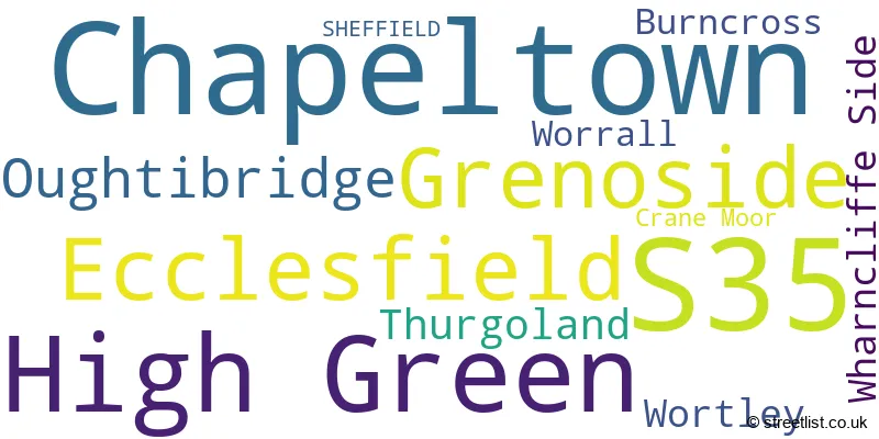
The largest settlement in the S35 postal code is Chapeltown followed by High Green, and Ecclesfield.
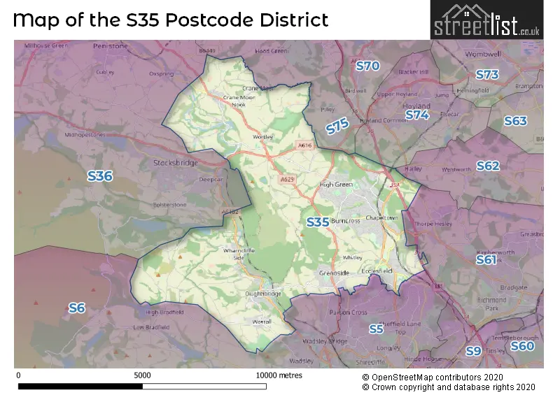
The S35 Postcode shares a border with S36 (Penistone, Stocksbridge, Deepcar), S75 (BARNSLEY, Darton, Dodworth), S6 (SHEFFIELD, Stannington, Loxley), S5 (SHEFFIELD) and S61 (ROTHERHAM, Thorpe Hesley, Scholes).
The primary settlement in the S35 postcode district is Chapeltown, located in the county of South Yorkshire, England. Other significant settlements within this postcode district include Oughtibridge, Wharncliffe Side, Worrall, Burncross, High Green, Crane Moor, Thurgoland, Wortley, and Grenoside. The most significant post town in this district is Sheffield.
For the district S35, we have data on 9 postcode sectors. Here's a breakdown: The sector S35 0, covers Oughtibridge and Wharncliffe Side and Worrall in South Yorkshire. The sector S35 1, covers Chapeltown and Burncross in South Yorkshire. The sector S35 2, covers Chapeltown in South Yorkshire. The sector S35 3, covers High Green and Chapeltown in South Yorkshire. The sector S35 4, covers High Green in South Yorkshire. The sector S35 5 is non-geographic. It's often designated for PO Boxes, large organisations, or special services. The sector S35 7, covers Thurgoland and Wortley and Crane Moor in South Yorkshire. The sector S35 8, covers Grenoside in South Yorkshire. The sector S35 9, covers Ecclesfield in South Yorkshire.

Map of the S35 Postcode District
Explore the S35 postcode district by using our free interactive map.
When it comes to local government, postal geography often disregards political borders. However, for a breakdown in the S35 District: the district mostly encompasses the Sheffield District (B) (785 postcodes), followed by the Barnsley District (B) area (97 postcodes), and finally, the Rotherham District (B) area (5 postcodes).
Recent House Sales in S35
| Date | Price | Address |
|---|---|---|
| 12/10/2023 | £470,500 | Beely Road, Oughtibridge, Sheffield, S35 0FD |
| 10/10/2023 | £135,000 | Chestnut Court, Oughtibridge, Sheffield, S35 0ER |
| 09/10/2023 | £293,500 | Chambers Valley Road, Chapeltown, Sheffield, S35 2YF |
| 25/09/2023 | £92,500 | Hurst Green, High Green, Sheffield, S35 4NH |
| 22/09/2023 | £200,000 | Charlton Brook Crescent, Chapeltown, Sheffield, S35 2XR |
| 15/09/2023 | £290,000 | Trickett Road, High Green, Sheffield, S35 4FN |
| 15/09/2023 | £238,500 | Oak Lodge Road, High Green, Sheffield, S35 4QA |
| 11/09/2023 | £120,000 | Kinsey Road, High Green, Sheffield, S35 4HU |
| 07/09/2023 | £115,000 | Kinsey Road, High Green, Sheffield, S35 4HU |
| 01/09/2023 | £180,000 | Westwood Road, High Green, Sheffield, S35 4LE |
Weather Forecast for S35
Press Button to Show Forecast for Grenoside
| Time Period | Icon | Description | Temperature | Rain Probability | Wind |
|---|---|---|---|---|---|
| 15:00 to 18:00 | Cloudy | 8.0°C (feels like 6.0°C) | 4.00% | N 7 mph | |
| 18:00 to 21:00 | Cloudy | 8.0°C (feels like 7.0°C) | 5.00% | NE 4 mph | |
| 21:00 to 00:00 | Cloudy | 6.0°C (feels like 5.0°C) | 8.00% | SSW 2 mph |
Press Button to Show Forecast for Grenoside
| Time Period | Icon | Description | Temperature | Rain Probability | Wind |
|---|---|---|---|---|---|
| 00:00 to 03:00 | Cloudy | 4.0°C (feels like 3.0°C) | 4.00% | WSW 4 mph | |
| 03:00 to 06:00 | Partly cloudy (night) | 4.0°C (feels like 1.0°C) | 0.00% | WSW 7 mph | |
| 06:00 to 09:00 | Partly cloudy (day) | 5.0°C (feels like 2.0°C) | 6.00% | W 9 mph | |
| 09:00 to 12:00 | Light rain | 7.0°C (feels like 4.0°C) | 48.00% | NW 9 mph | |
| 12:00 to 15:00 | Cloudy | 6.0°C (feels like 4.0°C) | 52.00% | N 7 mph | |
| 15:00 to 18:00 | Cloudy | 8.0°C (feels like 6.0°C) | 7.00% | NNW 7 mph | |
| 18:00 to 21:00 | Cloudy | 7.0°C (feels like 5.0°C) | 46.00% | NE 4 mph | |
| 21:00 to 00:00 | Partly cloudy (night) | 4.0°C (feels like 2.0°C) | 33.00% | NE 4 mph |
Press Button to Show Forecast for Grenoside
| Time Period | Icon | Description | Temperature | Rain Probability | Wind |
|---|---|---|---|---|---|
| 00:00 to 03:00 | Partly cloudy (night) | 2.0°C (feels like 0.0°C) | 1.00% | NNE 4 mph | |
| 03:00 to 06:00 | Clear night | 1.0°C (feels like -2.0°C) | 1.00% | NNW 4 mph | |
| 06:00 to 09:00 | Sunny day | 2.0°C (feels like -1.0°C) | 1.00% | NNW 4 mph | |
| 09:00 to 12:00 | Cloudy | 5.0°C (feels like 4.0°C) | 9.00% | NE 4 mph | |
| 12:00 to 15:00 | Overcast | 8.0°C (feels like 6.0°C) | 11.00% | ENE 4 mph | |
| 15:00 to 18:00 | Cloudy | 8.0°C (feels like 7.0°C) | 6.00% | ENE 4 mph | |
| 18:00 to 21:00 | Cloudy | 7.0°C (feels like 5.0°C) | 12.00% | ENE 7 mph | |
| 21:00 to 00:00 | Cloudy | 4.0°C (feels like 2.0°C) | 8.00% | E 4 mph |
Press Button to Show Forecast for Grenoside
| Time Period | Icon | Description | Temperature | Rain Probability | Wind |
|---|---|---|---|---|---|
| 00:00 to 03:00 | Cloudy | 3.0°C (feels like 2.0°C) | 7.00% | ESE 2 mph | |
| 03:00 to 06:00 | Partly cloudy (night) | 2.0°C (feels like 1.0°C) | 7.00% | NNE 4 mph | |
| 06:00 to 09:00 | Cloudy | 3.0°C (feels like 1.0°C) | 11.00% | NNE 4 mph | |
| 09:00 to 12:00 | Cloudy | 7.0°C (feels like 4.0°C) | 10.00% | ENE 7 mph | |
| 12:00 to 15:00 | Overcast | 8.0°C (feels like 6.0°C) | 17.00% | E 9 mph | |
| 15:00 to 18:00 | Cloudy | 9.0°C (feels like 6.0°C) | 21.00% | E 9 mph | |
| 18:00 to 21:00 | Cloudy | 8.0°C (feels like 5.0°C) | 17.00% | ENE 9 mph | |
| 21:00 to 00:00 | Cloudy | 6.0°C (feels like 3.0°C) | 17.00% | NE 9 mph |
Press Button to Show Forecast for Grenoside
| Time Period | Icon | Description | Temperature | Rain Probability | Wind |
|---|---|---|---|---|---|
| 00:00 to 03:00 | Light rain | 5.0°C (feels like 2.0°C) | 50.00% | NNE 9 mph | |
| 03:00 to 06:00 | Light rain | 5.0°C (feels like 2.0°C) | 51.00% | NNE 11 mph | |
| 06:00 to 09:00 | Heavy rain | 6.0°C (feels like 2.0°C) | 77.00% | NNE 11 mph | |
| 09:00 to 12:00 | Heavy rain | 7.0°C (feels like 4.0°C) | 79.00% | N 11 mph | |
| 12:00 to 15:00 | Heavy rain | 8.0°C (feels like 5.0°C) | 77.00% | N 11 mph | |
| 15:00 to 18:00 | Light rain | 8.0°C (feels like 5.0°C) | 56.00% | N 11 mph | |
| 18:00 to 21:00 | Light rain shower (day) | 8.0°C (feels like 6.0°C) | 35.00% | N 9 mph | |
| 21:00 to 00:00 | Partly cloudy (night) | 6.0°C (feels like 4.0°C) | 10.00% | NW 7 mph |
Where is the S35 Postcode District?
The postcode district of S35 is located in Sheffield. This district is nearby several towns such as Barnsley in the North East (approximately 6.67 miles away), Rotherham in the East (approximately 8.97 miles away), Dronfield in the South (approximately 11.61 miles away), Holmfirth in the North West (approximately 12.59 miles away), and Wakefield in the North (approximately 14.38 miles away). Additionally, S35 is approximately 147.64 miles away from the center of London.
The district is within the post town of SHEFFIELD.
The sector has postcodes within the nation of England.
The S35 Postcode District is covers the following regions.
- Sheffield - South Yorkshire - Yorkshire and The Humber
- Barnsley, Doncaster and Rotherham - South Yorkshire - Yorkshire and The Humber
| Postcode Sector | Delivery Office |
|---|---|
| S35 0 | Sheffield Npostal Delivery Office |
| S35 1 | Chapeltown Delivery Office |
| S35 2 | Chapeltown Delivery Office |
| S35 3 | Chapeltown Delivery Office |
| S35 4 | Chapeltown Delivery Office |
| S35 7 | Chapeltown Delivery Office |
| S35 8 | Chapeltown Delivery Office |
| S | 3 | 5 | - | X | X | X |
| S | 3 | 5 | Space | Numeric | Letter | Letter |
Current Monthly Rental Prices
| # Bedrooms | Min Price | Max Price | Avg Price |
|---|---|---|---|
| 2 | £725 | £750 | £742 |
| 3 | £895 | £1,450 | £1,148 |
| 4 | £1,200 | £1,200 | £1,200 |
| 5 | £2,850 | £2,850 | £2,850 |
Current House Prices
| # Bedrooms | Min Price | Max Price | Avg Price |
|---|---|---|---|
| £5,000 | £5,000 | £5,000 | |
| 1 | £40,000 | £150,000 | £87,000 |
| 2 | £45,000 | £425,000 | £201,427 |
| 3 | £120,000 | £900,000 | £274,652 |
| 4 | £240,000 | £1,200,000 | £472,860 |
| 5 | £1,150,000 | £1,150,000 | £1,150,000 |
| 6 | £450,000 | £1,650,000 | £850,000 |
Estate Agents who Operate in the S35 District
| Logo | Name | Brand Name | Address | Contact Number | Total Properties |
|---|---|---|---|---|---|
 | Chapeltown | Haybrook | 4 Lound Side, Chapeltown, Sheffield, S35 2UP | 0114 697 2559 | 36 |
 | Chapeltown | Blundells | Unit 4 Market Street, Chapeltown, S35 2UW | 0114 697 1186 | 22 |
 | Chapeltown | Your Move | 5 Market Street, Chapeltown, S35 2UW | 0114 697 3404 | 14 |
 | Chapeltown | Crucible Homes | 11, Lound Side, Chapeltown, S35 2UQ | 0114 697 2970 | 9 |
 | Hillsborough | Saxton Mee | 82 Middlewood Road, Sheffield, S6 4HA | 0114 697 4135 | 9 |
| Type of Property | 2018 Average | 2018 Sales | 2017 Average | 2017 Sales | 2016 Average | 2016 Sales | 2015 Average | 2015 Sales |
|---|---|---|---|---|---|---|---|---|
| Detached | £292,818 | 156 | £256,562 | 175 | £267,175 | 187 | £262,533 | 176 |
| Semi-Detached | £166,866 | 239 | £170,027 | 239 | £163,540 | 238 | £149,904 | 206 |
| Terraced | £142,897 | 137 | £137,654 | 158 | £133,099 | 168 | £118,200 | 181 |
| Flats | £101,939 | 51 | £95,207 | 89 | £101,060 | 52 | £94,075 | 46 |