The S35 0 postcode sector is within the county of South Yorkshire.
Did you know? According to the 2021 Census, the S35 0 postcode sector is home to a bustling 6,841 residents!
Given that each sector allows for 400 unique postcode combinations. Letters C, I, K, M, O and V are not allowed in the last two letters of a postcode. With 148 postcodes already in use, this leaves 252 units available.
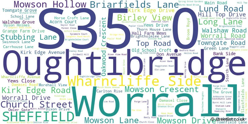
The largest settlement in the S35 0 postal code is Oughtibridge followed by Wharncliffe Side, and Worrall.
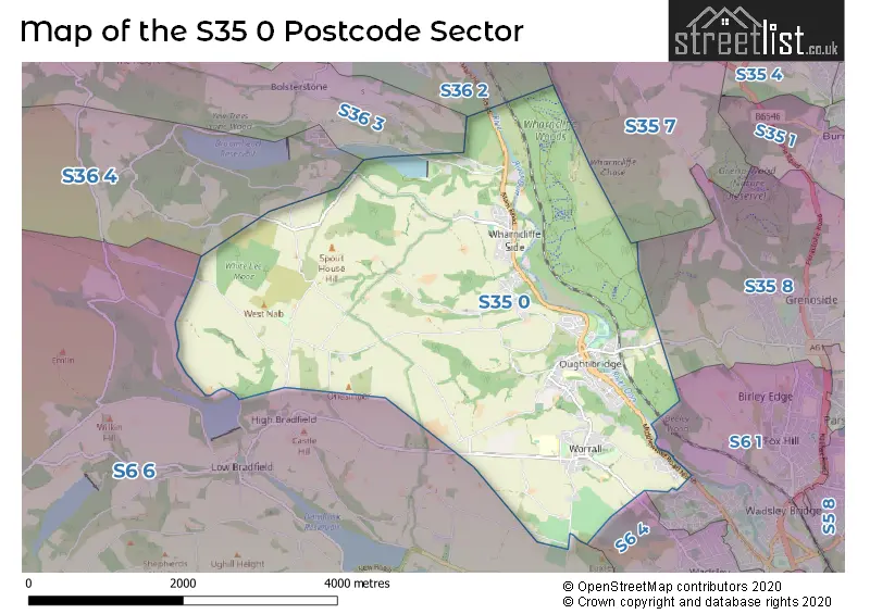
The S35 0 Postcode shares a border with S36 3 (Bolsterstone), S36 4 (Crow Edge, Stocksbridge, Dunford Bridge), S6 4 (SHEFFIELD), S36 2 (Deepcar, Stocksbridge), S6 1 (SHEFFIELD), S6 6 (Stannington, Loxley, Bradfield), S35 7 (Thurgoland, Wortley, Crane Moor) and S35 8 (Grenoside).
The sector is within the post town of SHEFFIELD.
S35 0 is a postcode sector within the S35 postcode district which is within the S Sheffield postcode area.
The Royal Mail delivery office for the S35 0 postal sector is the Sheffield Npostal Delivery Office.
The area of the S35 0 postcode sector is 8.43 square miles which is 21.84 square kilometres or 5,397.93 square acres.
Waterways within the S35 0 postcode sector include the Ewden Beck, River Don.

Map of the S35 0 Postcode Sector
Explore the S35 0 postcode sector by using our free interactive map.
| S | 3 | 5 | - | 0 | X | X |
| S | 3 | 5 | Space | 0 | Letter | Letter |
Official List of Streets
Oughtibridge (75 Streets)
Wharncliffe Side (31 Streets)
Worrall (25 Streets)
Unofficial Streets or Alternative Spellings
Grenoside
OUGHTIBRIDGE LANE ACRE LANE AGDEN SIDE ROAD BENT HILLS LANE BOLSTERSTONE ROAD BROWN HOUSE LANE BUD LANE COAL PIT LANE DAMASEL LANE DARWENT LANE DELF ROAD DICKEY LANE DYSON HOLMES LANE FAIRHURST LANE FLEET LANE HARE HILLS LANE HAZEL WAY HILLTOP DRIVE HOLLIN EDGE LANE JACKEY LANE LADY WHARNCLIFFES ROAD LINGARD LANE LOAD FIELD ROAD LODGE LANE LUMB LANE MOUSE PARK GATE OLD YEW GATE ONESACRE ROAD ONESMOOR BOTTOM ONESMOOR ROAD PALES WOOD GATE PEAT PITS LANE PENISTONE ROAD PLANK GATE PLATTS LANE RAYNOR SIKE LANE ROCHER LANE SMALLFIELD LANE UPPER DON TRAIL UPPER DON TRAIL (BEELEY WOOD) WALKER EDGE WESTNALL HOUSE WHITE LEE LANE WILLOW WALK WOODHEAD ROADLoxley
LONG LANE MYERS LANEBolsterstone
MORE HALL LANEDeepcar
MANCHESTER ROADWeather Forecast for S35 0
Press Button to Show Forecast for Low Bradfield
| Time Period | Icon | Description | Temperature | Rain Probability | Wind |
|---|---|---|---|---|---|
| 06:00 to 09:00 | Cloudy | 8.0°C (feels like 4.0°C) | 6.00% | NW 13 mph | |
| 09:00 to 12:00 | Cloudy | 9.0°C (feels like 6.0°C) | 13.00% | NW 13 mph | |
| 12:00 to 15:00 | Light rain shower (day) | 9.0°C (feels like 6.0°C) | 37.00% | N 13 mph | |
| 15:00 to 18:00 | Cloudy | 10.0°C (feels like 7.0°C) | 12.00% | N 11 mph | |
| 18:00 to 21:00 | Cloudy | 8.0°C (feels like 6.0°C) | 7.00% | NNE 7 mph | |
| 21:00 to 00:00 | Cloudy | 5.0°C (feels like 4.0°C) | 5.00% | N 4 mph |
Press Button to Show Forecast for Low Bradfield
| Time Period | Icon | Description | Temperature | Rain Probability | Wind |
|---|---|---|---|---|---|
| 00:00 to 03:00 | Cloudy | 4.0°C (feels like 2.0°C) | 4.00% | N 4 mph | |
| 03:00 to 06:00 | Cloudy | 3.0°C (feels like 1.0°C) | 4.00% | NNW 7 mph | |
| 06:00 to 09:00 | Cloudy | 4.0°C (feels like 1.0°C) | 5.00% | NNW 7 mph | |
| 09:00 to 12:00 | Cloudy | 6.0°C (feels like 4.0°C) | 5.00% | N 9 mph | |
| 12:00 to 15:00 | Overcast | 9.0°C (feels like 6.0°C) | 8.00% | N 9 mph | |
| 15:00 to 18:00 | Overcast | 10.0°C (feels like 8.0°C) | 9.00% | N 7 mph | |
| 18:00 to 21:00 | Cloudy | 9.0°C (feels like 8.0°C) | 6.00% | NNE 4 mph | |
| 21:00 to 00:00 | Partly cloudy (night) | 7.0°C (feels like 6.0°C) | 2.00% | NNE 4 mph |
Press Button to Show Forecast for Low Bradfield
| Time Period | Icon | Description | Temperature | Rain Probability | Wind |
|---|---|---|---|---|---|
| 00:00 to 03:00 | Cloudy | 6.0°C (feels like 5.0°C) | 4.00% | N 4 mph | |
| 03:00 to 06:00 | Partly cloudy (night) | 5.0°C (feels like 4.0°C) | 2.00% | NW 4 mph | |
| 06:00 to 09:00 | Cloudy | 6.0°C (feels like 5.0°C) | 9.00% | N 2 mph | |
| 09:00 to 12:00 | Overcast | 7.0°C (feels like 6.0°C) | 14.00% | NE 4 mph | |
| 12:00 to 15:00 | Overcast | 9.0°C (feels like 7.0°C) | 14.00% | NE 7 mph | |
| 15:00 to 18:00 | Overcast | 10.0°C (feels like 8.0°C) | 12.00% | NE 9 mph | |
| 18:00 to 21:00 | Cloudy | 9.0°C (feels like 7.0°C) | 8.00% | NE 7 mph | |
| 21:00 to 00:00 | Cloudy | 7.0°C (feels like 5.0°C) | 8.00% | ENE 7 mph |
Press Button to Show Forecast for Low Bradfield
| Time Period | Icon | Description | Temperature | Rain Probability | Wind |
|---|---|---|---|---|---|
| 00:00 to 03:00 | Cloudy | 5.0°C (feels like 4.0°C) | 9.00% | NE 4 mph | |
| 03:00 to 06:00 | Cloudy | 5.0°C (feels like 3.0°C) | 7.00% | NNE 4 mph | |
| 06:00 to 09:00 | Overcast | 5.0°C (feels like 4.0°C) | 11.00% | NE 4 mph | |
| 09:00 to 12:00 | Cloudy | 7.0°C (feels like 5.0°C) | 8.00% | ENE 7 mph | |
| 12:00 to 15:00 | Cloudy | 9.0°C (feels like 7.0°C) | 13.00% | ENE 7 mph | |
| 15:00 to 18:00 | Cloudy | 9.0°C (feels like 8.0°C) | 13.00% | NE 7 mph | |
| 18:00 to 21:00 | Cloudy | 9.0°C (feels like 7.0°C) | 10.00% | ENE 7 mph | |
| 21:00 to 00:00 | Cloudy | 7.0°C (feels like 5.0°C) | 8.00% | E 4 mph |
Schools and Places of Education Within the S35 0 Postcode Sector
Bradfield School
Academy converter
Kirk Edge Road, Sheffield, South Yorkshire, S35 0AE
Head: Mr Adrian May
Ofsted Rating: Requires improvement
Inspection: 2022-12-07 (499 days ago)
Website: Visit Bradfield School Website
Phone: 01142863861
Number of Pupils: 1059
Oughtibridge Primary School
Academy converter
Naylor Road, Sheffield, South Yorkshire, S35 0HG
Head: Mrs Helen Adams
Ofsted Rating: Outstanding
Inspection: 2023-11-29 (142 days ago)
Website: Visit Oughtibridge Primary School Website
Phone: 01142863167
Number of Pupils: 418
Wharncliffe Side Primary School
Academy converter
Brightholmlee Lane, Sheffield, South Yorkshire, S35 0DD
Head: Mr Matt Gaughan
Ofsted Rating: Good
Inspection: 2022-11-03 (533 days ago)
Website: Visit Wharncliffe Side Primary School Website
Phone: 01142862379
Number of Pupils: 161
House Prices in the S35 0 Postcode Sector
| Type of Property | 2018 Average | 2018 Sales | 2017 Average | 2017 Sales | 2016 Average | 2016 Sales | 2015 Average | 2015 Sales |
|---|---|---|---|---|---|---|---|---|
| Detached | £336,734 | 32 | £307,102 | 31 | £340,268 | 37 | £290,738 | 40 |
| Semi-Detached | £209,950 | 27 | £190,265 | 26 | £214,180 | 32 | £169,729 | 32 |
| Terraced | £196,062 | 19 | £163,557 | 26 | £170,085 | 39 | £136,334 | 43 |
| Flats | £144,214 | 7 | £115,615 | 17 | £118,621 | 14 | £109,454 | 11 |
Important Postcodes S35 0 in the Postcode Sector
S35 0AE is the postcode for SPORTS CENTRE, Bradfield School, Kirk Edge Road, Bradfield School, Kirk Edge Road, and MAIN SCHOOL, Bradfield School, Kirk Edge Road
S35 0DD is the postcode for Wharncliffe Side Primary School, Brightholmlee Lane
S35 0HG is the postcode for Oughtibridge Primary School, Naylor Road, Oughtbridge Primary School, Naylor Road, and OUGHTIBRIDGE PRIMARY SCHOOL, NAYLOR ROAD, SHEFFIELD
S35 0JW is the postcode for BUNGALOW 3, Sheffield Health & Social Care NHS Foundation Trust, 1-5 Forest Close, FOREST LODGE, 1-5 FOREST CLOSE, OUGHTIBRIDGE, BUNGALOW 1A, Sheffield Health & Social Care NHS Foundation Trust, 1-5 Forest Close, BUNGALOW 2, Sheffield Health & Social Care NHS Foundation Trust, 1-5 Forest Close, BUNGALOW 1, Sheffield Health & Social Care NHS Foundation Trust, 1-5 Forest Close, Sheffield Care Trust, Forest Close (tah), and Sheffield Health & Social Care NHS Foundation Trust, Forest Lodge
| The S35 0 Sector is within these Local Authorities |
|
|---|---|
| The S35 0 Sector is within these Counties |
|
| The S35 0 Sector is within these Water Company Areas |
|