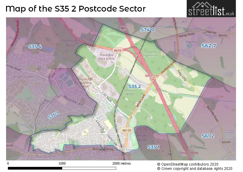
The S35 2 postcode sector is within the county of South Yorkshire.
Did you know? According to the 2021 Census, the S35 2 postcode sector is home to a bustling 5,660 residents!
Given that each sector allows for 400 unique postcode combinations. Letters C, I, K, M, O and V are not allowed in the last two letters of a postcode. With 122 postcodes already in use, this leaves 278 units available.
The S35 2 postal code covers the settlement of Chapeltown.
The S35 2 Postcode shares a border with S35 3 (High Green, Chapeltown), S35 4 (High Green), S62 7 (Rawmarsh, Wentworth, Harley), S74 0 (Hoyland, Jump, Blacker Hill), S35 1 (Chapeltown, Burncross) and S61 2 (ROTHERHAM, Thorpe Hesley, Scholes).
The sector is within the post town of SHEFFIELD.
S35 2 is a postcode sector within the S35 postcode district which is within the S Sheffield postcode area.
The Royal Mail delivery office for the S35 2 postal sector is the Chapeltown Delivery Office.
The area of the S35 2 postcode sector is 1.58 square miles which is 4.08 square kilometres or 1,008.68 square acres.
The S35 2 postcode sector is crossed by the M1 motorway.
The S35 2 postcode sector is crossed by the A616 Major A road.
Waterways within the S35 2 postcode sector include the Blackburn Brook.

Map of the S35 2 Postcode Sector
Explore the S35 2 postcode sector by using our free interactive map.
| S | 3 | 5 | - | 2 | X | X |
| S | 3 | 5 | Space | 2 | Letter | Letter |
Official List of Streets
Chapeltown (89 Streets)
Unofficial Streets or Alternative Spellings
Chapeltown
COWLEY LANE ECCLESFIELD ROAD HALL VIEW HEYHOUSE DRIVE HOLLOW GATEHigh Green
GRIFFITHS ROAD SCHOOL ROAD BLACKBURN VALLEY TRAIL BROOKDALE ROAD CHAMBERS WAY CHAPELTOWN ROUNDABOUT FAIRFIELD HALL ANNEX HALLOW GATE JOSELIN COURT NEWTON BUSINESS CENTRE NEWTON CHAMBER ROAD PARK LANE PARK SQUARE ROTUNDA BUSINESS CENTRE THORNCLIFFE HALL WEST WARREN LANEBurncross
BURNCROSS ROAD ORCHARD COURTBirdwell
SHEFFIELD ROADWeather Forecast for S35 2
Press Button to Show Forecast for Chapeltown
| Time Period | Icon | Description | Temperature | Rain Probability | Wind |
|---|---|---|---|---|---|
| 12:00 to 15:00 | Cloudy | 7.0°C (feels like 5.0°C) | 49.00% | N 7 mph | |
| 15:00 to 18:00 | Cloudy | 9.0°C (feels like 8.0°C) | 8.00% | N 7 mph | |
| 18:00 to 21:00 | Cloudy | 8.0°C (feels like 6.0°C) | 13.00% | NE 7 mph | |
| 21:00 to 00:00 | Partly cloudy (night) | 5.0°C (feels like 3.0°C) | 2.00% | NE 4 mph |
Press Button to Show Forecast for Chapeltown
| Time Period | Icon | Description | Temperature | Rain Probability | Wind |
|---|---|---|---|---|---|
| 00:00 to 03:00 | Partly cloudy (night) | 2.0°C (feels like 1.0°C) | 1.00% | NNE 4 mph | |
| 03:00 to 06:00 | Clear night | 1.0°C (feels like -1.0°C) | 1.00% | NNW 4 mph | |
| 06:00 to 09:00 | Partly cloudy (day) | 2.0°C (feels like 0.0°C) | 1.00% | NNW 4 mph | |
| 09:00 to 12:00 | Cloudy | 6.0°C (feels like 5.0°C) | 6.00% | NE 4 mph | |
| 12:00 to 15:00 | Overcast | 8.0°C (feels like 7.0°C) | 9.00% | NE 4 mph | |
| 15:00 to 18:00 | Cloudy | 9.0°C (feels like 8.0°C) | 10.00% | ENE 4 mph | |
| 18:00 to 21:00 | Cloudy | 7.0°C (feels like 5.0°C) | 10.00% | E 7 mph | |
| 21:00 to 00:00 | Cloudy | 5.0°C (feels like 4.0°C) | 9.00% | NE 4 mph |
Press Button to Show Forecast for Chapeltown
| Time Period | Icon | Description | Temperature | Rain Probability | Wind |
|---|---|---|---|---|---|
| 00:00 to 03:00 | Cloudy | 4.0°C (feels like 3.0°C) | 8.00% | NE 2 mph | |
| 03:00 to 06:00 | Partly cloudy (night) | 3.0°C (feels like 1.0°C) | 7.00% | NNE 4 mph | |
| 06:00 to 09:00 | Cloudy | 4.0°C (feels like 1.0°C) | 11.00% | NNE 4 mph | |
| 09:00 to 12:00 | Cloudy | 8.0°C (feels like 5.0°C) | 11.00% | ENE 7 mph | |
| 12:00 to 15:00 | Overcast | 9.0°C (feels like 7.0°C) | 18.00% | E 9 mph | |
| 15:00 to 18:00 | Overcast | 10.0°C (feels like 8.0°C) | 20.00% | ENE 9 mph | |
| 18:00 to 21:00 | Cloudy | 9.0°C (feels like 6.0°C) | 18.00% | ENE 9 mph | |
| 21:00 to 00:00 | Cloudy | 6.0°C (feels like 4.0°C) | 16.00% | NE 9 mph |
Press Button to Show Forecast for Chapeltown
| Time Period | Icon | Description | Temperature | Rain Probability | Wind |
|---|---|---|---|---|---|
| 00:00 to 03:00 | Cloudy | 6.0°C (feels like 3.0°C) | 22.00% | NNE 9 mph | |
| 03:00 to 06:00 | Light rain | 6.0°C (feels like 3.0°C) | 51.00% | NNE 11 mph | |
| 06:00 to 09:00 | Heavy rain | 7.0°C (feels like 4.0°C) | 78.00% | NNE 11 mph | |
| 09:00 to 12:00 | Heavy rain | 8.0°C (feels like 5.0°C) | 79.00% | NNE 11 mph | |
| 12:00 to 15:00 | Heavy rain | 9.0°C (feels like 7.0°C) | 78.00% | NNE 11 mph | |
| 15:00 to 18:00 | Light rain shower (day) | 10.0°C (feels like 7.0°C) | 40.00% | NNW 11 mph | |
| 18:00 to 21:00 | Overcast | 9.0°C (feels like 7.0°C) | 19.00% | NW 9 mph | |
| 21:00 to 00:00 | Partly cloudy (night) | 7.0°C (feels like 5.0°C) | 9.00% | SE 7 mph |
Schools and Places of Education Within the S35 2 Postcode Sector
Lound Infant School
Academy converter
Sherburn Gate, Sheffield, South Yorkshire, S35 2EU
Head: Mrs Sarah Palmer
Ofsted Rating: Good
Inspection: 2022-11-03 (539 days ago)
Website: Visit Lound Infant School Website
Phone: 01142462181
Number of Pupils: 149
Lound Junior School
Academy converter
Lound Side, Sheffield, South Yorkshire, S35 2UT
Head: Mrs Sarah Palmer
Ofsted Rating: Good
Inspection: 2022-09-14 (589 days ago)
Website: Visit Lound Junior School Website
Phone: 01142462181
Number of Pupils: 221
Paces School for Conductive Education
Non-maintained special school
Thorncliffe Hall, Sheffield, , S35 2PH
Head: Mrs Ruth Liu
Ofsted Rating: Good
Inspection: 2019-02-13 (1898 days ago)
Website: Visit Paces School for Conductive Education Website
Phone: 01142845298
Number of Pupils: 46
House Prices in the S35 2 Postcode Sector
| Type of Property | 2018 Average | 2018 Sales | 2017 Average | 2017 Sales | 2016 Average | 2016 Sales | 2015 Average | 2015 Sales |
|---|---|---|---|---|---|---|---|---|
| Detached | £268,676 | 27 | £254,336 | 25 | £226,203 | 32 | £241,229 | 24 |
| Semi-Detached | £162,045 | 39 | £159,533 | 45 | £151,068 | 33 | £150,651 | 38 |
| Terraced | £123,225 | 22 | £123,795 | 22 | £113,906 | 27 | £110,985 | 30 |
| Flats | £111,250 | 4 | £110,400 | 5 | £84,190 | 5 | £92,900 | 5 |
Important Postcodes S35 2 in the Postcode Sector
S35 2EU is the postcode for Lound Infant School, Sherburn Gate
S35 2UT is the postcode for Steel City Partnership, Lound Academy, Mafeking Place, and Lound Academy, Mafeking Place
S35 2XE is the postcode for Sheffield Homes, Chambers Court, 1b Station Road
| The S35 2 Sector is within these Local Authorities |
|
|---|---|
| The S35 2 Sector is within these Counties |
|
| The S35 2 Sector is within these Water Company Areas |
|