The S40 postcode district is a postal district located in the S Sheffield postcode area with a population of 34,693 residents according to the 2021 England and Wales Census.
The area of the S40 postcode district is 4.42 square miles which is 11.45 square kilometres or 2,828.66 acres.
Currently, the S40 district has about 1092 postcode units spread across 4 geographic postcode sectors.
Given that each sector allows for 400 unique postcode combinations, the district has a capacity of 1,600 postcodes. With 1092 postcodes already in use, this leaves 508 units available.
The S40 postal code covers the settlement of CHESTERFIELD.
The S40 Postcode shares a border with S41 (CHESTERFIELD, Hasland, Old Whittington) and S42 (Wingerworth, North Wingfield, Holmewood).
The primary settlement in the S40 postcode district is Chesterfield, located in Derbyshire.
For the district S40, we have data on 5 postcode sectors. Here's a breakdown: The sector S40 1, covers Chesterfield in Derbyshire. The sector S40 2, covers Chesterfield in Derbyshire. The sector S40 3, covers Chesterfield in Derbyshire. The sector S40 4, covers Chesterfield in Derbyshire. The sector S40 9 is non-geographic. It's often designated for PO Boxes, large organisations, or special services.

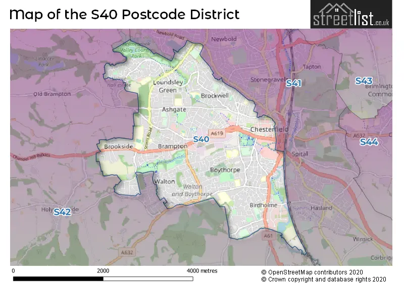
Map of the S40 Postcode District
Explore the S40 postcode district by using our free interactive map.
When it comes to local government, postal geography often disregards political borders. However, for a breakdown in the S40 District: the district mostly encompasses the Chesterfield District (B) area with a total of 1094 postcodes.
Recent House Sales in S40
| Date | Price | Address |
|---|---|---|
| 30/10/2023 | £315,000 | Amber Crescent, Chesterfield, S40 3DH |
| 13/10/2023 | £223,000 | Horsley Close, Chesterfield, S40 4XD |
| 06/10/2023 | £370,000 | Lake View Avenue, Chesterfield, S40 3DR |
| 28/09/2023 | £85,000 | Alford Close, Chesterfield, S40 1YP |
| 15/09/2023 | £115,000 | Glenthorne Close, Chesterfield, S40 3AR |
| 11/09/2023 | £105,000 | Compton Street, Chesterfield, S40 4TA |
| 08/09/2023 | £180,000 | Chatsworth Road, Chesterfield, S40 3JX |
| 08/09/2023 | £113,000 | Chatsworth Road, Chesterfield, S40 3BJ |
| 08/09/2023 | £240,000 | Heaton Street, Chesterfield, S40 3AQ |
| 08/09/2023 | £110,000 | Archdale Close, Chesterfield, S40 2GF |
Weather Forecast for S40
Press Button to Show Forecast for Chesterfield
| Time Period | Icon | Description | Temperature | Rain Probability | Wind |
|---|---|---|---|---|---|
| 06:00 to 09:00 | Cloudy | 5.0°C (feels like 2.0°C) | 3.00% | WSW 9 mph | |
| 09:00 to 12:00 | Cloudy | 8.0°C (feels like 5.0°C) | 11.00% | WNW 9 mph | |
| 12:00 to 15:00 | Light rain | 7.0°C (feels like 5.0°C) | 45.00% | N 7 mph | |
| 15:00 to 18:00 | Cloudy | 8.0°C (feels like 7.0°C) | 49.00% | NNE 4 mph | |
| 18:00 to 21:00 | Cloudy | 8.0°C (feels like 7.0°C) | 6.00% | NE 7 mph | |
| 21:00 to 00:00 | Cloudy | 5.0°C (feels like 4.0°C) | 10.00% | ESE 4 mph |
Press Button to Show Forecast for Chesterfield
| Time Period | Icon | Description | Temperature | Rain Probability | Wind |
|---|---|---|---|---|---|
| 00:00 to 03:00 | Partly cloudy (night) | 4.0°C (feels like 2.0°C) | 1.00% | ENE 4 mph | |
| 03:00 to 06:00 | Partly cloudy (night) | 2.0°C (feels like 0.0°C) | 1.00% | NNE 4 mph | |
| 06:00 to 09:00 | Sunny day | 3.0°C (feels like 1.0°C) | 1.00% | N 4 mph | |
| 09:00 to 12:00 | Cloudy | 7.0°C (feels like 5.0°C) | 6.00% | NE 4 mph | |
| 12:00 to 15:00 | Cloudy | 9.0°C (feels like 8.0°C) | 9.00% | ENE 4 mph | |
| 15:00 to 18:00 | Cloudy | 9.0°C (feels like 8.0°C) | 10.00% | ENE 4 mph | |
| 18:00 to 21:00 | Cloudy | 7.0°C (feels like 5.0°C) | 11.00% | ENE 9 mph | |
| 21:00 to 00:00 | Cloudy | 5.0°C (feels like 3.0°C) | 10.00% | ENE 7 mph |
Press Button to Show Forecast for Chesterfield
| Time Period | Icon | Description | Temperature | Rain Probability | Wind |
|---|---|---|---|---|---|
| 00:00 to 03:00 | Partly cloudy (night) | 4.0°C (feels like 2.0°C) | 8.00% | NE 4 mph | |
| 03:00 to 06:00 | Cloudy | 4.0°C (feels like 1.0°C) | 11.00% | NE 4 mph | |
| 06:00 to 09:00 | Partly cloudy (day) | 4.0°C (feels like 1.0°C) | 7.00% | NE 7 mph | |
| 09:00 to 12:00 | Cloudy | 8.0°C (feels like 5.0°C) | 12.00% | ENE 9 mph | |
| 12:00 to 15:00 | Overcast | 9.0°C (feels like 7.0°C) | 21.00% | ENE 9 mph | |
| 15:00 to 18:00 | Overcast | 10.0°C (feels like 8.0°C) | 21.00% | ENE 11 mph | |
| 18:00 to 21:00 | Cloudy | 9.0°C (feels like 7.0°C) | 18.00% | ENE 11 mph | |
| 21:00 to 00:00 | Cloudy | 7.0°C (feels like 4.0°C) | 15.00% | NE 11 mph |
Press Button to Show Forecast for Chesterfield
| Time Period | Icon | Description | Temperature | Rain Probability | Wind |
|---|---|---|---|---|---|
| 00:00 to 03:00 | Overcast | 7.0°C (feels like 3.0°C) | 22.00% | NE 11 mph | |
| 03:00 to 06:00 | Light rain | 7.0°C (feels like 3.0°C) | 52.00% | NNE 13 mph | |
| 06:00 to 09:00 | Heavy rain | 7.0°C (feels like 3.0°C) | 76.00% | NNE 13 mph | |
| 09:00 to 12:00 | Heavy rain | 8.0°C (feels like 5.0°C) | 78.00% | NE 13 mph | |
| 12:00 to 15:00 | Heavy rain | 10.0°C (feels like 7.0°C) | 79.00% | N 13 mph | |
| 15:00 to 18:00 | Light rain shower (day) | 10.0°C (feels like 7.0°C) | 42.00% | N 11 mph | |
| 18:00 to 21:00 | Light rain | 10.0°C (feels like 7.0°C) | 48.00% | NNE 9 mph | |
| 21:00 to 00:00 | Cloudy | 8.0°C (feels like 6.0°C) | 11.00% | SW 7 mph |
Where is the S40 Postcode District?
The postcode district S40 is located in Chesterfield. Chesterfield is situated in the North of Dronfield, South West of Matlock, South of Alfreton, West of Bakewell, and South East of Sutton-in-Ashfield. Additionally, it is approximately 131.73 miles away from the center of London.
The district covers the post towns of CHESTERFIELD, HOPE VALLEY.
The sector has postcodes within the nation of England.
The S40 Postcode District is in the East Derbyshire region of Derbyshire and Nottinghamshire within the East Midlands (England).
| Postcode Sector | Delivery Office |
|---|---|
| S40 1 | Chesterfield Delivery Office |
| S40 2 | Chesterfield Delivery Office |
| S40 3 | Chesterfield Delivery Office |
| S40 4 | Chesterfield Delivery Office |
| S | 4 | 0 | - | X | X | X |
| S | 4 | 0 | Space | Numeric | Letter | Letter |
Current Monthly Rental Prices
| # Bedrooms | Min Price | Max Price | Avg Price |
|---|---|---|---|
| 1 | £475 | £700 | £581 |
| 2 | £595 | £800 | £709 |
| 3 | £850 | £1,100 | £981 |
| 4 | £1,400 | £1,400 | £1,400 |
Current House Prices
| # Bedrooms | Min Price | Max Price | Avg Price |
|---|---|---|---|
| £100,000 | £500,000 | £275,000 | |
| 1 | £72,500 | £149,950 | £118,996 |
| 2 | £52,500 | £325,000 | £172,975 |
| 3 | £120,000 | £750,000 | £270,219 |
| 4 | £164,950 | £720,000 | £403,404 |
| 5 | £425,000 | £950,000 | £590,714 |
| 6 | £200,000 | £695,000 | £482,000 |
Estate Agents who Operate in the S40 District
| Logo | Name | Brand Name | Address | Contact Number | Total Properties |
|---|---|---|---|---|---|
 | Chesterfield | Redbrik | 13-15 Glumangate, Chesterfield, S40 1TX | 01246 383327 | 45 |
 | Chesterfield | Wilkins Vardy Residential | 23 Glumangate Chesterfield Derbyshire, S40 1TX | 01246 383354 | 33 |
 | Chesterfield | Wards Estate Agents | 17 Glumangate, Chesterfield, S40 1TX | 01246 383321 | 22 |
 | Chesterfield | Hunters | Unit 4, The Glass Yard, Sheffield Road, Chesterfield S41 8JY | 01246 383383 | 19 |
 | Chesterfield | Pinewood Properties | 33 Holywell Street, Chesterfield, S41 7SA | 01243 973393 | 15 |
| Type of Property | 2018 Average | 2018 Sales | 2017 Average | 2017 Sales | 2016 Average | 2016 Sales | 2015 Average | 2015 Sales |
|---|---|---|---|---|---|---|---|---|
| Detached | £296,104 | 175 | £279,990 | 190 | £269,010 | 175 | £253,730 | 192 |
| Semi-Detached | £169,941 | 220 | £160,376 | 257 | £155,215 | 216 | £149,435 | 230 |
| Terraced | £126,291 | 135 | £119,542 | 137 | £109,999 | 145 | £110,187 | 131 |
| Flats | £115,662 | 37 | £118,204 | 38 | £104,151 | 28 | £108,172 | 37 |