The S41 0 postcode sector is within the county of Derbyshire.
Did you know? According to the 2021 Census, the S41 0 postcode sector is home to a bustling 12,729 residents!
Given that each sector allows for 400 unique postcode combinations. Letters C, I, K, M, O and V are not allowed in the last two letters of a postcode. With 289 postcodes already in use, this leaves 111 units available.
The largest settlements in the S41 0 postal code are CHESTERFIELD and Hasland.
The S41 0 Postcode shares a border with S41 7 (CHESTERFIELD), S44 5 (Calow, Duckmanton, Glapwell), S40 2 (CHESTERFIELD), S41 9 (Old Whittington, CHESTERFIELD, Whittington Moor), S42 5 (North Wingfield, Holmewood, Grassmoor), S42 6 (Wingerworth, New Tupton, Old Tupton) and S43 1 (Brimington).
The sector is within the post town of CHESTERFIELD.
S41 0 is a postcode sector within the S41 postcode district which is within the S Sheffield postcode area.
The Royal Mail delivery office for the S41 0 postal sector is the Chesterfield Delivery Office.
The area of the S41 0 postcode sector is 3.40 square miles which is 8.80 square kilometres or 2,173.97 square acres.
Waterways within the S41 0 postcode sector include the River Hipper, Calow Brook, River Rother, Chesterfield Canal.

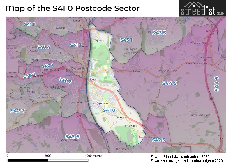
Map of the S41 0 Postcode Sector
Explore the S41 0 postcode sector by using our free interactive map.
| S | 4 | 1 | - | 0 | X | X |
| S | 4 | 1 | Space | 0 | Letter | Letter |
Official List of Streets
CHESTERFIELD (92 Streets)
Hasland (89 Streets)
Unofficial Streets or Alternative Spellings
Calow
CALOW LANE CHESTERFIELD ROAD HASSOCKY LANE SYCAMORE DRIVE AVENUE 1 AVENUE 2 AVENUE 3 AVENUE 4 AVENUE 5 AVENUE 6 AVENUE 7 AVENUE 8 CHESTEFIELD FP 7 CHESTERFIELD FP 103 CHESTERFIELD FP 118 CHESTERFIELD FP 139 CHESTERFIELD FP 19 CHESTERFIELD FP 203 CHESTERFIELD FP101 CHESTERFIELD FP11 CHESTERFIELD FP116 CHESTERFIELD FP13 CHESTERFIELD FP180 CHESTERFIELD FP181 CHESTERFIELD FP5 CHESTERFIELD FP6 CHESTERFIELD FP8 CHESTERFIELD FP9 CHESTERFIELD ROAD CIRCULAR ROAD FIVE PITS TRAIL FURNACE HILLOCK WAY GREEN LANE HAZEL HURST HIGH VIEW CLOSE MIDLAND COURT MIDLAND TERRACE NORTH TERRACE PARK DRIVE PARK VIEW ROAD RAILWAY TERRACE TAPTON HALL DRIVE TATON GROVE TRAFFIC TERRACE TROUGHBROOK HILL WETLANDS LANE WHEATHILL LANE WHITEHOUSES WISTON CLOSEHasland
STORFORTH LANE TERRACECHESTERFIELD
HOLLIS LANEGrassmoor
NORTH WINGFIELD ROADWeather Forecast for S41 0
Press Button to Show Forecast for Chesterfield
| Time Period | Icon | Description | Temperature | Rain Probability | Wind |
|---|---|---|---|---|---|
| 21:00 to 00:00 | Partly cloudy (night) | 6.0°C (feels like 4.0°C) | 1.00% | N 7 mph |
Press Button to Show Forecast for Chesterfield
| Time Period | Icon | Description | Temperature | Rain Probability | Wind |
|---|---|---|---|---|---|
| 00:00 to 03:00 | Clear night | 5.0°C (feels like 3.0°C) | 1.00% | NNW 4 mph | |
| 03:00 to 06:00 | Partly cloudy (night) | 4.0°C (feels like 2.0°C) | 1.00% | NNW 7 mph | |
| 06:00 to 09:00 | Partly cloudy (day) | 5.0°C (feels like 2.0°C) | 1.00% | NNW 7 mph | |
| 09:00 to 12:00 | Cloudy | 7.0°C (feels like 5.0°C) | 4.00% | N 9 mph | |
| 12:00 to 15:00 | Cloudy | 10.0°C (feels like 8.0°C) | 7.00% | N 9 mph | |
| 15:00 to 18:00 | Overcast | 11.0°C (feels like 9.0°C) | 7.00% | N 7 mph | |
| 18:00 to 21:00 | Overcast | 10.0°C (feels like 8.0°C) | 7.00% | NNE 7 mph | |
| 21:00 to 00:00 | Cloudy | 8.0°C (feels like 6.0°C) | 4.00% | NE 4 mph |
Press Button to Show Forecast for Chesterfield
| Time Period | Icon | Description | Temperature | Rain Probability | Wind |
|---|---|---|---|---|---|
| 00:00 to 03:00 | Cloudy | 6.0°C (feels like 5.0°C) | 5.00% | NE 4 mph | |
| 03:00 to 06:00 | Cloudy | 6.0°C (feels like 5.0°C) | 11.00% | NNE 4 mph | |
| 06:00 to 09:00 | Cloudy | 5.0°C (feels like 4.0°C) | 14.00% | NNE 4 mph | |
| 09:00 to 12:00 | Overcast | 7.0°C (feels like 5.0°C) | 14.00% | NNE 7 mph | |
| 12:00 to 15:00 | Overcast | 8.0°C (feels like 6.0°C) | 13.00% | NNE 7 mph | |
| 15:00 to 18:00 | Overcast | 9.0°C (feels like 7.0°C) | 13.00% | NE 9 mph | |
| 18:00 to 21:00 | Overcast | 9.0°C (feels like 7.0°C) | 11.00% | NE 7 mph | |
| 21:00 to 00:00 | Cloudy | 7.0°C (feels like 5.0°C) | 8.00% | ENE 7 mph |
Press Button to Show Forecast for Chesterfield
| Time Period | Icon | Description | Temperature | Rain Probability | Wind |
|---|---|---|---|---|---|
| 00:00 to 03:00 | Partly cloudy (night) | 5.0°C (feels like 4.0°C) | 8.00% | NE 4 mph | |
| 03:00 to 06:00 | Overcast | 5.0°C (feels like 3.0°C) | 15.00% | NE 2 mph | |
| 06:00 to 09:00 | Cloudy | 5.0°C (feels like 4.0°C) | 19.00% | NNE 4 mph | |
| 09:00 to 12:00 | Cloudy | 7.0°C (feels like 5.0°C) | 19.00% | ESE 4 mph | |
| 12:00 to 15:00 | Heavy rain | 8.0°C (feels like 6.0°C) | 72.00% | E 4 mph | |
| 15:00 to 18:00 | Light rain | 9.0°C (feels like 8.0°C) | 51.00% | ENE 4 mph | |
| 18:00 to 21:00 | Cloudy | 9.0°C (feels like 8.0°C) | 44.00% | NNE 4 mph | |
| 21:00 to 00:00 | Overcast | 8.0°C (feels like 7.0°C) | 13.00% | NNE 4 mph |
Press Button to Show Forecast for Chesterfield
| Time Period | Icon | Description | Temperature | Rain Probability | Wind |
|---|---|---|---|---|---|
| 00:00 to 03:00 | Overcast | 7.0°C (feels like 6.0°C) | 11.00% | NNE 4 mph | |
| 03:00 to 06:00 | Overcast | 6.0°C (feels like 5.0°C) | 10.00% | NNE 7 mph | |
| 06:00 to 09:00 | Overcast | 6.0°C (feels like 4.0°C) | 10.00% | NNE 7 mph | |
| 09:00 to 12:00 | Overcast | 8.0°C (feels like 6.0°C) | 10.00% | N 9 mph | |
| 12:00 to 15:00 | Overcast | 10.0°C (feels like 8.0°C) | 11.00% | NNE 9 mph | |
| 15:00 to 18:00 | Cloudy | 11.0°C (feels like 9.0°C) | 12.00% | NNE 9 mph | |
| 18:00 to 21:00 | Partly cloudy (day) | 10.0°C (feels like 8.0°C) | 4.00% | NNE 9 mph | |
| 21:00 to 00:00 | Partly cloudy (night) | 8.0°C (feels like 6.0°C) | 2.00% | NNE 7 mph |
Schools and Places of Education Within the S41 0 Postcode Sector
Hady Primary School
Community school
Hady Lane, Chesterfield, Derbyshire, S41 0DF
Head: Mrs Susan Chapman
Ofsted Rating: Good
Inspection: 2018-03-15 (2227 days ago)
Website: Visit Hady Primary School Website
Phone: 01246279254
Number of Pupils: 334
Hasland Infant School
Community school
Eyre Street East, Chesterfield, Derbyshire, S41 0PE
Head: Mrs Charlotte Lavender
Ofsted Rating: Good
Inspection: 2022-11-24 (512 days ago)
Website: Visit Hasland Infant School Website
Phone: 01246234745
Number of Pupils: 341
Hasland Junior School
Community school
Broomfield Avenue, Chesterfield, Derbyshire, S41 0LY
Head: Mr Matthew Winson
Ofsted Rating: Good
Inspection: 2022-01-26 (814 days ago)
Website: Visit Hasland Junior School Website
Phone: 01246234250
Number of Pupils: 379
Outwood Academy Hasland Hall
Academy sponsor led
Broomfield Avenue, Chesterfield, Derbyshire, S41 0LP
Head: Mr Ian Cooper
Ofsted Rating: Good
Inspection: 2023-11-09 (162 days ago)
Website: Visit Outwood Academy Hasland Hall Website
Phone: 01246273985
Number of Pupils: 784
House Prices in the S41 0 Postcode Sector
| Type of Property | 2018 Average | 2018 Sales | 2017 Average | 2017 Sales | 2016 Average | 2016 Sales | 2015 Average | 2015 Sales |
|---|---|---|---|---|---|---|---|---|
| Detached | £249,854 | 70 | £244,610 | 86 | £237,212 | 65 | £219,817 | 83 |
| Semi-Detached | £152,419 | 97 | £146,054 | 100 | £140,022 | 90 | £136,040 | 74 |
| Terraced | £125,382 | 64 | £116,106 | 60 | £115,867 | 63 | £109,808 | 70 |
| Flats | £106,923 | 13 | £108,575 | 10 | £97,250 | 10 | £104,750 | 14 |
Important Postcodes S41 0 in the Postcode Sector
S41 0DF is the postcode for Hady Primary School, Hady Lane
S41 0EQ is the postcode for Tapton Park Golf Club, Murray House, Crow Lane
S41 0HZ is the postcode for Hasland Resource Centre, Heather Vale Road
S41 0LN is the postcode for Hasland Junior School, The Green
S41 0LP is the postcode for MAIN BUILDING, Outwood Academy Hasland Hall, Broomfield Avenue, BLOCK 11 - MATHS BLOCK, Hasland Hall Community School, Broomfield Avenue, BLOCK 04 - SPORTS HALL, Hasland Hall Community School, Broomfield Avenue, MAIN BUILDING, Hasland Hall Community School, Broomfield Avenue, BLOCKS 02 AND 03 - OLD HALL, Outwood Academy Hasland Hall, Broomfield Avenue, BLOCKS 02 AND 03 - OLD HALL, Hasland Hall Community School, Broomfield Avenue, BLOCK 06 IT BLOCK, Hasland Hall Community School, Broomfield Avenue, BLOCK 12 - LANGUAGES BLOCK, Hasland Hall Community School, Broomfield Avenue, and BLOCK 05 - DINING ROOM, Hasland Hall Community School, Broomfield Avenue
S41 0LY is the postcode for HASLAND JUNIOR SCHOOL, BROOMFIELD AVENUE, HASLAND, and Hasland Junior School, Broomfield Avenue
S41 0NZ is the postcode for Hasland Medical Centre, 1 Jepson Road
S41 0PE is the postcode for Hasland Infant School, Eyre Street East, and MAIN BUILDING, Hasland Infant School, Eyre Street East
S41 0RG is the postcode for Doctors Surgery, 82 St. Philips Drive
S41 0TD is the postcode for Chesterfield College, Tapton House Campus, Brimington Road
| The S41 0 Sector is within these Local Authorities |
|
|---|---|
| The S41 0 Sector is within these Counties |
|
| The S41 0 Sector is within these Water Company Areas |
|