The S41 9 postcode sector is within the county of Derbyshire.
Did you know? According to the 2021 Census, the S41 9 postcode sector is home to a bustling 5,657 residents!
Given that each sector allows for 400 unique postcode combinations. Letters C, I, K, M, O and V are not allowed in the last two letters of a postcode. With 199 postcodes already in use, this leaves 201 units available.
The largest settlement in the S41 9 postal code is Old Whittington followed by CHESTERFIELD, and Whittington Moor.
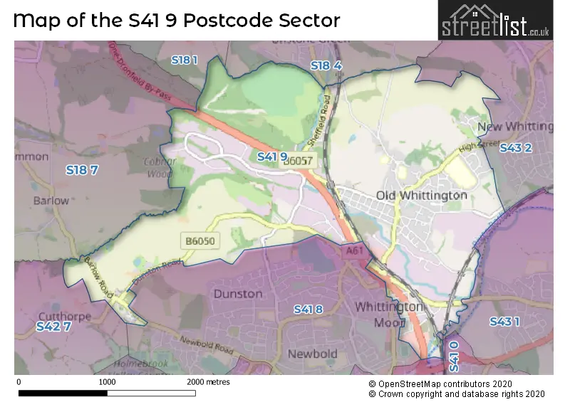
The S41 9 Postcode shares a border with S41 7 (CHESTERFIELD), S41 8 (CHESTERFIELD), S18 1 (DRONFIELD), S18 4 (Unstone, Apperknowle), S18 7 (Barlow, Holmesfield, DRONFIELD), S41 0 (CHESTERFIELD, Hasland), S42 7 (Holymoorside, Walton, Ashgate), S43 1 (Brimington) and S43 2 (New Whittington, Hollingwood, Barrow Hill).
The sector is within the post town of CHESTERFIELD.
S41 9 is a postcode sector within the S41 postcode district which is within the S Sheffield postcode area.
The Royal Mail delivery office for the S41 9 postal sector is the Chesterfield Delivery Office.
The area of the S41 9 postcode sector is 3.41 square miles which is 8.82 square kilometres or 2,180.35 square acres.
Waterways within the S41 9 postcode sector include the Barlow Brook, River Whitting, River Drone, River Rother, Sud Brook, Chesterfield Canal.

Map of the S41 9 Postcode Sector
Explore the S41 9 postcode sector by using our free interactive map.
| S | 4 | 1 | - | 9 | X | X |
| S | 4 | 1 | Space | 9 | Letter | Letter |
Official List of Streets
CHESTERFIELD (47 Streets)
Old Whittington (54 Streets)
Unofficial Streets or Alternative Spellings
CHESTERFIELD
CUTTHORPE ROADNew Whittington
HIGH STREET STATION LANEBrimington
NEWBRIDGE LANEWhittington Moor
DUNSTON ROAD CARLISLE CLOSE CHURCH STREET DISCOVERY WAY FOXLEY CLOSE GYPSY LANE HOLLY CLOSE HOLLY HOUSE SCHOOL SIDDALL�S WALK THE POPLARS UNSTONE-DRONFIELD BY-PASSUnstone
SHEFFIELD ROAD WHITTINGTON LANEApperknowle
WINDMILL LANEBarlow
HACKNEY LANEWeather Forecast for S41 9
Press Button to Show Forecast for Dronfield
| Time Period | Icon | Description | Temperature | Rain Probability | Wind |
|---|---|---|---|---|---|
| 00:00 to 03:00 | Cloudy | 5.0°C (feels like 4.0°C) | 4.00% | WSW 4 mph | |
| 03:00 to 06:00 | Cloudy | 4.0°C (feels like 1.0°C) | 4.00% | WSW 7 mph | |
| 06:00 to 09:00 | Cloudy | 4.0°C (feels like 2.0°C) | 4.00% | WSW 7 mph | |
| 09:00 to 12:00 | Overcast | 7.0°C (feels like 4.0°C) | 16.00% | NW 9 mph | |
| 12:00 to 15:00 | Light rain | 6.0°C (feels like 4.0°C) | 48.00% | N 9 mph | |
| 15:00 to 18:00 | Cloudy | 8.0°C (feels like 7.0°C) | 8.00% | N 4 mph | |
| 18:00 to 21:00 | Cloudy | 7.0°C (feels like 5.0°C) | 6.00% | NE 7 mph | |
| 21:00 to 00:00 | Cloudy | 5.0°C (feels like 3.0°C) | 8.00% | NNE 4 mph |
Press Button to Show Forecast for Dronfield
| Time Period | Icon | Description | Temperature | Rain Probability | Wind |
|---|---|---|---|---|---|
| 00:00 to 03:00 | Cloudy | 3.0°C (feels like 1.0°C) | 4.00% | NE 4 mph | |
| 03:00 to 06:00 | Partly cloudy (night) | 2.0°C (feels like 0.0°C) | 1.00% | NNE 4 mph | |
| 06:00 to 09:00 | Sunny day | 2.0°C (feels like 0.0°C) | 1.00% | N 4 mph | |
| 09:00 to 12:00 | Partly cloudy (day) | 6.0°C (feels like 4.0°C) | 2.00% | NE 7 mph | |
| 12:00 to 15:00 | Overcast | 8.0°C (feels like 7.0°C) | 9.00% | ENE 4 mph | |
| 15:00 to 18:00 | Cloudy | 9.0°C (feels like 8.0°C) | 9.00% | ENE 4 mph | |
| 18:00 to 21:00 | Cloudy | 8.0°C (feels like 5.0°C) | 8.00% | E 7 mph | |
| 21:00 to 00:00 | Cloudy | 5.0°C (feels like 3.0°C) | 8.00% | ENE 7 mph |
Press Button to Show Forecast for Dronfield
| Time Period | Icon | Description | Temperature | Rain Probability | Wind |
|---|---|---|---|---|---|
| 00:00 to 03:00 | Cloudy | 3.0°C (feels like 1.0°C) | 8.00% | NE 4 mph | |
| 03:00 to 06:00 | Cloudy | 3.0°C (feels like 1.0°C) | 11.00% | NE 4 mph | |
| 06:00 to 09:00 | Partly cloudy (day) | 4.0°C (feels like 1.0°C) | 8.00% | NE 7 mph | |
| 09:00 to 12:00 | Cloudy | 7.0°C (feels like 4.0°C) | 11.00% | ENE 9 mph | |
| 12:00 to 15:00 | Cloudy | 9.0°C (feels like 6.0°C) | 19.00% | ENE 9 mph | |
| 15:00 to 18:00 | Overcast | 10.0°C (feels like 7.0°C) | 21.00% | ENE 11 mph | |
| 18:00 to 21:00 | Cloudy | 9.0°C (feels like 6.0°C) | 19.00% | ENE 11 mph | |
| 21:00 to 00:00 | Cloudy | 7.0°C (feels like 3.0°C) | 17.00% | NE 11 mph |
Press Button to Show Forecast for Dronfield
| Time Period | Icon | Description | Temperature | Rain Probability | Wind |
|---|---|---|---|---|---|
| 00:00 to 03:00 | Light rain | 6.0°C (feels like 3.0°C) | 48.00% | NE 11 mph | |
| 03:00 to 06:00 | Light rain | 6.0°C (feels like 2.0°C) | 50.00% | NNE 13 mph | |
| 06:00 to 09:00 | Heavy rain | 6.0°C (feels like 3.0°C) | 79.00% | NNE 13 mph | |
| 09:00 to 12:00 | Light rain | 8.0°C (feels like 4.0°C) | 57.00% | NNE 13 mph | |
| 12:00 to 15:00 | Light rain shower (day) | 9.0°C (feels like 6.0°C) | 46.00% | NNE 13 mph | |
| 15:00 to 18:00 | Light rain | 9.0°C (feels like 7.0°C) | 52.00% | NE 11 mph | |
| 18:00 to 21:00 | Overcast | 9.0°C (feels like 7.0°C) | 21.00% | N 9 mph | |
| 21:00 to 00:00 | Partly cloudy (night) | 7.0°C (feels like 5.0°C) | 10.00% | SSE 7 mph |
Schools and Places of Education Within the S41 9 Postcode Sector
Holly House Special School
Community special school
Church Street North, Chesterfield, Derbyshire, S41 9QR
Head: Mr Marc Hughes
Ofsted Rating: Requires improvement
Inspection: 2023-01-11 (470 days ago)
Website: Visit Holly House Special School Website
Phone: 01246450530
Number of Pupils: 45
Mary Swanwick Primary School
Academy converter
Church Street North, Chesterfield, Derbyshire, S41 9QW
Head: Mrs Katie Parr
Ofsted Rating: Good
Inspection: 2022-11-09 (533 days ago)
Website: Visit Mary Swanwick Primary School Website
Phone: 01246450597
Number of Pupils: 253
Whittington Green School
Community school
High Street, Chesterfield, Derbyshire, S41 9LG
Head: Mrs Tracey Burnside
Ofsted Rating: Good
Inspection: 2023-02-09 (441 days ago)
Website: Visit Whittington Green School Website
Phone: 01246450825
Number of Pupils: 537
House Prices in the S41 9 Postcode Sector
| Type of Property | 2018 Average | 2018 Sales | 2017 Average | 2017 Sales | 2016 Average | 2016 Sales | 2015 Average | 2015 Sales |
|---|---|---|---|---|---|---|---|---|
| Detached | £228,250 | 14 | £242,932 | 22 | £223,232 | 17 | £240,216 | 16 |
| Semi-Detached | £125,213 | 23 | £114,339 | 34 | £111,163 | 32 | £109,398 | 35 |
| Terraced | £122,405 | 21 | £111,950 | 20 | £122,984 | 35 | £92,373 | 20 |
| Flats | £144,300 | 5 | £91,486 | 7 | £144,000 | 6 | £145,400 | 5 |
Important Postcodes S41 9 in the Postcode Sector
S41 9BE is the postcode for Main Building, County Transport Brimington Workshop, Brimington Road North, and County Transport Brimington Workshop, Brimington Road North
S41 9EY is the postcode for N I C Certification Ltd, Unit 3, Whitting Valley Road, Old Whittington
S41 9LG is the postcode for NEW BUILD, Whittington Green School,, 142 High Street, Whittington Green School, 142 High Street, SPORTS HALL, Whittington Green School, 142 High Street, NEW BUILD, Whittington Green School, 142 High Street, and Whittington Green School, 142 High Street, Old Whittington
S41 9ND is the postcode for 1, Glebe Court, The Glebe
S41 9QR is the postcode for NEW BLOCK, Holly House School, Church Street North, and MAIN BUILDING, Holly House School, Church Street North
S41 9QW is the postcode for KEY STAGE 2 BUILDING, Mary Swanwick Primary School, Church Street North, KEY STAGE 1 AND NURSERY BUILDING, Mary Swanwick Primary School, Church Street North, MARY SWANWICK PRIMARY SCHOOL, CHURCH STREET NORTH, Whittington Children's Centre, Church Street North, HALL, KITCHEN & ANNEX, Mary Swanwick Primary School, Church Street North, and SPORTS HALL, MARY SWANWICK PRIMARY SCHOOL, CHURCH STREET NORTH
| The S41 9 Sector is within these Local Authorities |
|
|---|---|
| The S41 9 Sector is within these Counties |
|
| The S41 9 Sector is within these Water Company Areas |
|
Tourist Attractions within the S41 9 Postcode Area
We found 1 visitor attractions within the S41 postcode area
| Revolution House |
|---|
| Historic Properties |
| Historic House / House and Garden / Palace |
| View Revolution House on Google Maps |