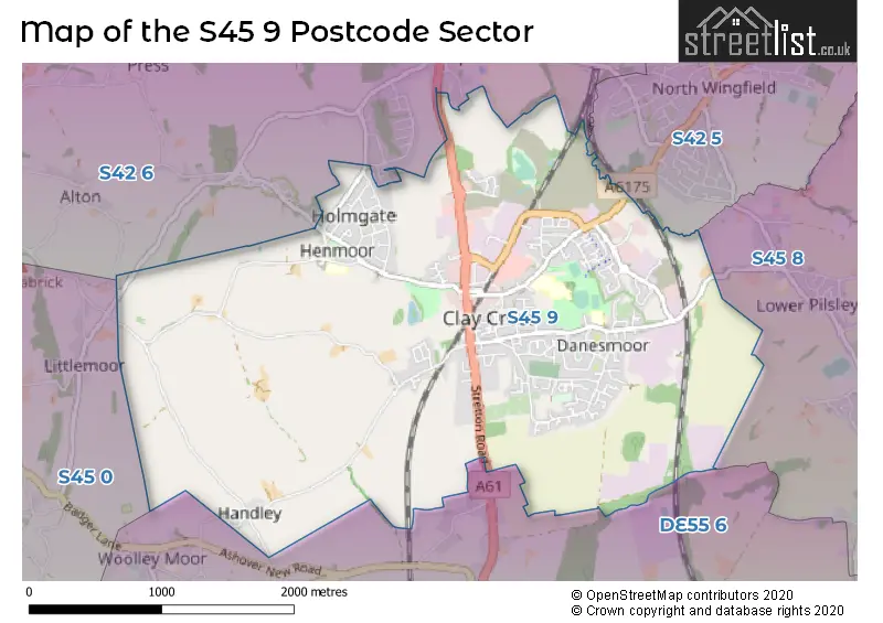
The S45 9 postcode sector is within the county of Derbyshire.
Did you know? According to the 2021 Census, the S45 9 postcode sector is home to a bustling 9,164 residents!
Given that each sector allows for 400 unique postcode combinations. Letters C, I, K, M, O and V are not allowed in the last two letters of a postcode. With 250 postcodes already in use, this leaves 150 units available.
The largest settlements in the S45 9 postal code are Clay Cross and Danesmoor.
The S45 9 Postcode shares a border with S45 0 (Ashover), S45 8 (Pilsley, Lower Pilsley), DE55 6 (Shirland, Stonebroom, Morton), S42 5 (North Wingfield, Holmewood, Grassmoor) and S42 6 (Wingerworth, New Tupton, Old Tupton).
The sector is within the post town of CHESTERFIELD.
S45 9 is a postcode sector within the S45 postcode district which is within the S Sheffield postcode area.
The Royal Mail delivery office for the S45 9 postal sector is the Chesterfield Delivery Office.
The area of the S45 9 postcode sector is 4.18 square miles which is 10.83 square kilometres or 2,676.97 square acres.
Waterways within the S45 9 postcode sector include the River Rother.

Map of the S45 9 Postcode Sector
Explore the S45 9 postcode sector by using our free interactive map.
| S | 4 | 5 | - | 9 | X | X |
| S | 4 | 5 | Space | 9 | Letter | Letter |
Official List of Streets
Clay Cross (137 Streets)
Danesmoor (52 Streets)
Unofficial Streets or Alternative Spellings
Old Tupton
BRASSINGTON LANE HAREWOOD CRESCENT MILL LANE RIBER CRESCENTAshover
ASHOVER ROADAlton
TINKLEY LANEWeather Forecast for S45 9
Press Button to Show Forecast for Clay Cross
| Time Period | Icon | Description | Temperature | Rain Probability | Wind |
|---|---|---|---|---|---|
| 06:00 to 09:00 | Partly cloudy (day) | 5.0°C (feels like 1.0°C) | 2.00% | WSW 9 mph | |
| 09:00 to 12:00 | Cloudy | 7.0°C (feels like 4.0°C) | 49.00% | NW 9 mph | |
| 12:00 to 15:00 | Light rain | 6.0°C (feels like 4.0°C) | 50.00% | N 7 mph | |
| 15:00 to 18:00 | Cloudy | 8.0°C (feels like 6.0°C) | 6.00% | NNE 4 mph | |
| 18:00 to 21:00 | Cloudy | 8.0°C (feels like 6.0°C) | 6.00% | NE 7 mph | |
| 21:00 to 00:00 | Cloudy | 5.0°C (feels like 3.0°C) | 10.00% | ENE 4 mph |
Press Button to Show Forecast for Clay Cross
| Time Period | Icon | Description | Temperature | Rain Probability | Wind |
|---|---|---|---|---|---|
| 00:00 to 03:00 | Partly cloudy (night) | 2.0°C (feels like 0.0°C) | 1.00% | NE 2 mph | |
| 03:00 to 06:00 | Clear night | 1.0°C (feels like -1.0°C) | 1.00% | N 4 mph | |
| 06:00 to 09:00 | Sunny day | 2.0°C (feels like 0.0°C) | 1.00% | N 4 mph | |
| 09:00 to 12:00 | Cloudy | 6.0°C (feels like 4.0°C) | 5.00% | ENE 7 mph | |
| 12:00 to 15:00 | Overcast | 8.0°C (feels like 7.0°C) | 9.00% | ENE 4 mph | |
| 15:00 to 18:00 | Cloudy | 9.0°C (feels like 8.0°C) | 7.00% | E 4 mph | |
| 18:00 to 21:00 | Cloudy | 7.0°C (feels like 5.0°C) | 12.00% | ENE 7 mph | |
| 21:00 to 00:00 | Partly cloudy (night) | 4.0°C (feels like 3.0°C) | 7.00% | ENE 4 mph |
Press Button to Show Forecast for Clay Cross
| Time Period | Icon | Description | Temperature | Rain Probability | Wind |
|---|---|---|---|---|---|
| 00:00 to 03:00 | Cloudy | 3.0°C (feels like 1.0°C) | 9.00% | NNE 4 mph | |
| 03:00 to 06:00 | Cloudy | 2.0°C (feels like 0.0°C) | 12.00% | NNE 4 mph | |
| 06:00 to 09:00 | Cloudy | 4.0°C (feels like 1.0°C) | 11.00% | NNE 7 mph | |
| 09:00 to 12:00 | Cloudy | 7.0°C (feels like 4.0°C) | 12.00% | ENE 9 mph | |
| 12:00 to 15:00 | Overcast | 9.0°C (feels like 7.0°C) | 19.00% | ENE 9 mph | |
| 15:00 to 18:00 | Cloudy | 10.0°C (feels like 7.0°C) | 21.00% | ENE 9 mph | |
| 18:00 to 21:00 | Cloudy | 9.0°C (feels like 6.0°C) | 18.00% | ENE 9 mph | |
| 21:00 to 00:00 | Cloudy | 6.0°C (feels like 3.0°C) | 16.00% | NE 9 mph |
Press Button to Show Forecast for Clay Cross
| Time Period | Icon | Description | Temperature | Rain Probability | Wind |
|---|---|---|---|---|---|
| 00:00 to 03:00 | Cloudy | 6.0°C (feels like 2.0°C) | 19.00% | NE 11 mph | |
| 03:00 to 06:00 | Light rain | 6.0°C (feels like 2.0°C) | 51.00% | NNE 11 mph | |
| 06:00 to 09:00 | Heavy rain | 6.0°C (feels like 3.0°C) | 76.00% | NNE 13 mph | |
| 09:00 to 12:00 | Heavy rain | 7.0°C (feels like 4.0°C) | 78.00% | NNE 13 mph | |
| 12:00 to 15:00 | Heavy rain | 9.0°C (feels like 6.0°C) | 74.00% | NNE 13 mph | |
| 15:00 to 18:00 | Light rain | 9.0°C (feels like 6.0°C) | 53.00% | NNE 11 mph | |
| 18:00 to 21:00 | Cloudy | 9.0°C (feels like 7.0°C) | 15.00% | NNE 9 mph | |
| 21:00 to 00:00 | Partly cloudy (night) | 6.0°C (feels like 5.0°C) | 9.00% | SSE 7 mph |
Schools and Places of Education Within the S45 9 Postcode Sector
Holmgate Primary School and Nursery
Community school
Holmgate Road, Chesterfield, Derbyshire, S45 9QD
Head: Mrs Ffion Thornton
Ofsted Rating: Good
Inspection: 2023-06-08 (322 days ago)
Website: Visit Holmgate Primary School and Nursery Website
Phone: 01246862270
Number of Pupils: 248
Sharley Park Community Primary School
Community school
Sharley Park Community Primary School, Pilsley Road, Chesterfield, Derbyshire, S45 9BN
Head: Ms Nicola Stevenson
Ofsted Rating: Good
Inspection: 2023-04-19 (372 days ago)
Website: Visit Sharley Park Community Primary School Website
Phone: 01246864833
Number of Pupils: 400
House Prices in the S45 9 Postcode Sector
| Type of Property | 2018 Average | 2018 Sales | 2017 Average | 2017 Sales | 2016 Average | 2016 Sales | 2015 Average | 2015 Sales |
|---|---|---|---|---|---|---|---|---|
| Detached | £218,618 | 59 | £229,372 | 32 | £195,154 | 43 | £180,730 | 27 |
| Semi-Detached | £154,559 | 75 | £132,473 | 39 | £116,973 | 30 | £110,965 | 29 |
| Terraced | £101,462 | 59 | £93,158 | 46 | £86,632 | 47 | £92,828 | 52 |
| Flats | £86,250 | 2 | £75,750 | 4 | £76,250 | 4 | £95,167 | 6 |
Important Postcodes S45 9 in the Postcode Sector
S45 9BJ is the postcode for Derbyshire Constabulary, Clay Cross Police Station, Pilsley Road
S45 9BN is the postcode for Sharley Park Community Primary School, Pilsley Road, SHARLEY PARK COMMUNITY PRIMARY SCHOOL, PILSLEY ROAD, DANESMOOR, and Sharley Park Community School, Pilsley Road
S45 9JB is the postcode for Derbyshire County Council, High Street
S45 9JE is the postcode for WHOLE BUILDING, Adult Community Education Centre, Market Street, and Adult Community Education Centre, Market Street
S45 9JQ is the postcode for Derbyshire Fire & Rescue Service, Fire Station, Market Street
S45 9LX is the postcode for Clay Cross Resource Centre, Market Street, Clay Cross, SHARLEY PARK LEISURE CENTRE, MARKET STREET, CLAY CROSS, Sharley Park Leisure Centre, Market Street, and Clay Cross Resource Centre, Market Street
S45 9NG is the postcode for Clay Cross Medical Centre, Bridge Street
S45 9NR is the postcode for Blue Dykes Surgery, Eldon Street
S45 9NZ is the postcode for CLAY CROSS HOSPITAL, MARKET STREET, CLAY CROSS HOSPITAL, MARKET STREET, CLAY CROSS, Clay Cross Community Hospital, Market Street, and Derbyshire County PCT, Clay Cross Hospital
S45 9QD is the postcode for HOLMGATE PRIMARY SCHOOL & NURSERY, HOLMGATE ROAD, CLAY CROSS, and Holmgate Primary School & Nursery, Holmgate Road
| The S45 9 Sector is within these Local Authorities |
|
|---|---|
| The S45 9 Sector is within these Counties |
|
| The S45 9 Sector is within these Water Company Areas |
|