The S5 6 postcode sector is within the county of South Yorkshire.
Did you know? According to the 2021 Census, the S5 6 postcode sector is home to a bustling 13,260 residents!
Given that each sector allows for 400 unique postcode combinations. Letters C, I, K, M, O and V are not allowed in the last two letters of a postcode. With 210 postcodes already in use, this leaves 190 units available.
The S5 6 postal code covers the settlement of SHEFFIELD.
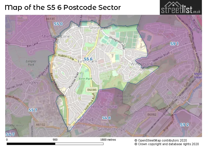
The S5 6 Postcode shares a border with S4 8 (SHEFFIELD), S5 0 (SHEFFIELD), S5 7 (SHEFFIELD) and S9 1 (SHEFFIELD, Tinsley).
The sector is within the post town of SHEFFIELD.
S5 6 is a postcode sector within the S5 postcode district which is within the S Sheffield postcode area.
The Royal Mail delivery office for the S5 6 postal sector is the Sheffield Nepostal Delivery Office.
The area of the S5 6 postcode sector is 0.91 square miles which is 2.35 square kilometres or 580.34 square acres.

Map of the S5 6 Postcode Sector
Explore the S5 6 postcode sector by using our free interactive map.
| S | 5 | - | 6 | X | X |
| S | 5 | Space | 6 | Letter | Letter |
Official List of Streets
SHEFFIELD (98 Streets)
Unofficial Streets or Alternative Spellings
Weather Forecast for S5 6
Press Button to Show Forecast for Pismire Hill
| Time Period | Icon | Description | Temperature | Rain Probability | Wind |
|---|---|---|---|---|---|
| 00:00 to 03:00 | Cloudy | 5.0°C (feels like 4.0°C) | 3.00% | WSW 4 mph | |
| 03:00 to 06:00 | Partly cloudy (night) | 4.0°C (feels like 1.0°C) | 0.00% | WSW 9 mph | |
| 06:00 to 09:00 | Partly cloudy (day) | 5.0°C (feels like 3.0°C) | 5.00% | W 9 mph | |
| 09:00 to 12:00 | Light rain | 7.0°C (feels like 5.0°C) | 48.00% | NW 9 mph | |
| 12:00 to 15:00 | Light rain | 6.0°C (feels like 4.0°C) | 52.00% | NNE 7 mph | |
| 15:00 to 18:00 | Cloudy | 9.0°C (feels like 7.0°C) | 6.00% | N 4 mph | |
| 18:00 to 21:00 | Overcast | 8.0°C (feels like 6.0°C) | 11.00% | ENE 7 mph | |
| 21:00 to 00:00 | Cloudy | 5.0°C (feels like 3.0°C) | 5.00% | NE 4 mph |
Press Button to Show Forecast for Pismire Hill
| Time Period | Icon | Description | Temperature | Rain Probability | Wind |
|---|---|---|---|---|---|
| 00:00 to 03:00 | Partly cloudy (night) | 3.0°C (feels like 1.0°C) | 1.00% | NNE 4 mph | |
| 03:00 to 06:00 | Clear night | 2.0°C (feels like 0.0°C) | 1.00% | NNW 4 mph | |
| 06:00 to 09:00 | Sunny day | 2.0°C (feels like 0.0°C) | 1.00% | NNW 4 mph | |
| 09:00 to 12:00 | Cloudy | 6.0°C (feels like 4.0°C) | 4.00% | ENE 4 mph | |
| 12:00 to 15:00 | Overcast | 8.0°C (feels like 7.0°C) | 10.00% | ENE 4 mph | |
| 15:00 to 18:00 | Cloudy | 9.0°C (feels like 8.0°C) | 7.00% | ENE 4 mph | |
| 18:00 to 21:00 | Cloudy | 7.0°C (feels like 5.0°C) | 9.00% | ENE 7 mph | |
| 21:00 to 00:00 | Partly cloudy (night) | 4.0°C (feels like 3.0°C) | 7.00% | E 4 mph |
Press Button to Show Forecast for Pismire Hill
| Time Period | Icon | Description | Temperature | Rain Probability | Wind |
|---|---|---|---|---|---|
| 00:00 to 03:00 | Cloudy | 4.0°C (feels like 3.0°C) | 9.00% | ESE 4 mph | |
| 03:00 to 06:00 | Partly cloudy (night) | 3.0°C (feels like 1.0°C) | 8.00% | NNE 4 mph | |
| 06:00 to 09:00 | Cloudy | 4.0°C (feels like 2.0°C) | 11.00% | NNE 4 mph | |
| 09:00 to 12:00 | Cloudy | 7.0°C (feels like 5.0°C) | 12.00% | ENE 7 mph | |
| 12:00 to 15:00 | Overcast | 9.0°C (feels like 7.0°C) | 20.00% | ENE 9 mph | |
| 15:00 to 18:00 | Cloudy | 10.0°C (feels like 7.0°C) | 21.00% | ENE 9 mph | |
| 18:00 to 21:00 | Cloudy | 9.0°C (feels like 6.0°C) | 19.00% | ENE 9 mph | |
| 21:00 to 00:00 | Cloudy | 6.0°C (feels like 4.0°C) | 17.00% | NE 9 mph |
Press Button to Show Forecast for Pismire Hill
| Time Period | Icon | Description | Temperature | Rain Probability | Wind |
|---|---|---|---|---|---|
| 00:00 to 03:00 | Overcast | 5.0°C (feels like 2.0°C) | 22.00% | NNE 9 mph | |
| 03:00 to 06:00 | Light rain | 6.0°C (feels like 2.0°C) | 51.00% | NNE 11 mph | |
| 06:00 to 09:00 | Heavy rain | 6.0°C (feels like 3.0°C) | 75.00% | NNE 11 mph | |
| 09:00 to 12:00 | Heavy rain | 7.0°C (feels like 4.0°C) | 79.00% | NNE 11 mph | |
| 12:00 to 15:00 | Heavy rain | 9.0°C (feels like 6.0°C) | 78.00% | N 11 mph | |
| 15:00 to 18:00 | Light rain | 9.0°C (feels like 6.0°C) | 50.00% | N 11 mph | |
| 18:00 to 21:00 | Light rain shower (day) | 9.0°C (feels like 7.0°C) | 37.00% | N 9 mph | |
| 21:00 to 00:00 | Partly cloudy (night) | 7.0°C (feels like 5.0°C) | 9.00% | SE 7 mph |
Schools and Places of Education Within the S5 6 Postcode Sector
Hatfield Academy
Academy converter
Hatfield House Lane, Sheffield, South Yorkshire, S5 6HY
Head: Mrs Katy Richards
Ofsted Rating: Good
Inspection: 2023-03-29 (393 days ago)
Website: Visit Hatfield Academy Website
Phone: 01142456871
Number of Pupils: 376
Hinde House 2-16 Academy
Academy converter
Shiregreen Lane, Sheffield, South Yorkshire, S5 6AG
Head: Mr Munif Zia
Ofsted Rating: Good
Inspection: 2021-09-24 (944 days ago)
Website: Visit Hinde House 2-16 Academy Website
Phone: 01142438486
Number of Pupils: 1382
Hucklow Primary School
Academy converter
Hucklow Road, Sheffield, South Yorkshire, S5 6TB
Head: Mrs Laura Duckworth
Ofsted Rating: Good
Inspection: 2019-03-05 (1878 days ago)
Website: Visit Hucklow Primary School Website
Phone: 01142426736
Number of Pupils: 521
Longley Park Sixth Form Academy
Academy 16-19 converter
Horninglow Road, Sheffield, South Yorkshire, S5 6SG
Head: Mr Jamie Davies
Ofsted Rating: Good
Inspection: 2018-10-05 (2029 days ago)
Website: Visit Longley Park Sixth Form Academy Website
Phone: 01142625757
Number of Pupils: 0
House Prices in the S5 6 Postcode Sector
| Type of Property | 2018 Average | 2018 Sales | 2017 Average | 2017 Sales | 2016 Average | 2016 Sales | 2015 Average | 2015 Sales |
|---|---|---|---|---|---|---|---|---|
| Detached | £107,250 | 5 | £141,690 | 5 | £111,000 | 2 | £144,833 | 3 |
| Semi-Detached | £96,549 | 41 | £96,697 | 45 | £89,513 | 34 | £79,342 | 36 |
| Terraced | £80,783 | 64 | £76,209 | 70 | £77,131 | 53 | £88,553 | 67 |
| Flats | £73,922 | 12 | £76,938 | 8 | £87,996 | 21 | £87,873 | 21 |
Important Postcodes S5 6 in the Postcode Sector
S5 6AE is the postcode for Concord Sports Centre, Shiregreen Lane, and Sheffield International Venues Ltd, Concord Sports Centre, Shiregreen Lane
S5 6AG is the postcode for Hinde House School, Shiregreen Lane, and SPORTS HALL, Hinde House School, Shiregreen Lane
S5 6AZ is the postcode for Bluebell Medical Centre, Wincobank Avenue, and The Flowers Health Centre, 87 Wincobank Avenue
S5 6FH is the postcode for Hinde House Primary School, Bracken Road
S5 6HH is the postcode for First Start Childrens Centre, 441 Firth Park Road, and Firth Park Surgery, 398-402 Firth Park Road
S5 6HY is the postcode for Hatfield Primary School, Hatfield House Lane, Hatfield Academy, Hatfield House Lane, HATFIELD ACADEMY, HATFIELD HOUSE LANE, SHEFFIELD, BUILDING B TERRAPIN BLOCK, Hatfield Primary School, Hatfield House Lane, and BUILDING C CANTEEN BLOCK, Hatfield Primary School, Hatfield House Lane
S5 6NU is the postcode for Firth Park Clinic, 40 North Quadrant
S5 6QQ is the postcode for Firth Park Library, 439-443 Firth Park Road
S5 6SG is the postcode for Longley Park Sixth Form College, Horninglow Road
S5 6TB is the postcode for TERRAPIN BUILDING BUILDING B, Hucklow Primary School, Hucklow Road, HUCKLOW PRIMARY SCHOOL, HUCKLOW ROAD, SHEFFIELD, and Hucklow Primary School, Hucklow Road
S5 6WS is the postcode for Firth Park Pavilion, Firth Park Road
| The S5 6 Sector is within these Local Authorities |
|
|---|---|
| The S5 6 Sector is within these Counties |
|
| The S5 6 Sector is within these Water Company Areas |
|