The S5 7 postcode sector is within the county of South Yorkshire.
Did you know? According to the 2021 Census, the S5 7 postcode sector is home to a bustling 13,246 residents!
Given that each sector allows for 400 unique postcode combinations. Letters C, I, K, M, O and V are not allowed in the last two letters of a postcode. With 236 postcodes already in use, this leaves 164 units available.
The S5 7 postal code covers the settlement of SHEFFIELD.
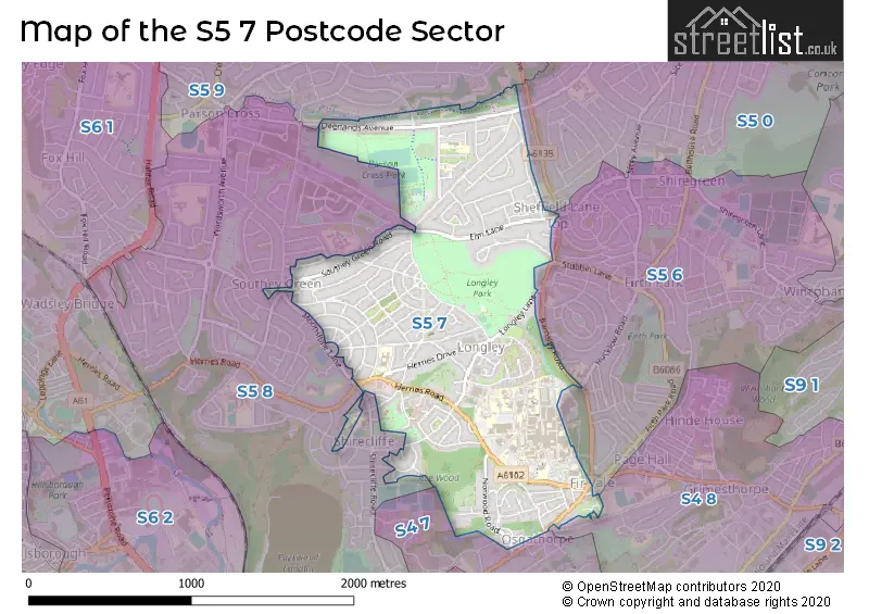
The S5 7 Postcode shares a border with S4 7 (SHEFFIELD), S4 8 (SHEFFIELD), S5 6 (SHEFFIELD), S5 0 (SHEFFIELD), S5 8 (SHEFFIELD) and S5 9 (SHEFFIELD).
The sector is within the post town of SHEFFIELD.
S5 7 is a postcode sector within the S5 postcode district which is within the S Sheffield postcode area.
The Royal Mail delivery office for the S5 7 postal sector is the Sheffield Nepostal Delivery Office.
The area of the S5 7 postcode sector is 1.17 square miles which is 3.04 square kilometres or 751.73 square acres.

Map of the S5 7 Postcode Sector
Explore the S5 7 postcode sector by using our free interactive map.
| S | 5 | - | 7 | X | X |
| S | 5 | Space | 7 | Letter | Letter |
Official List of Streets
SHEFFIELD (102 Streets)
Unofficial Streets or Alternative Spellings
SHEFFIELD
BIRCHLANDS DRIVE BUCHANAN ROAD CALDER WAY COLLINSON ROAD EARL MARSHAL ROAD FIRSHILL AVENUE GALSWORTHY AVENUE HATFIELD HOUSE LANE HILLTOP GREEN HOLGATE CRESCENT LONGLEY AVENUE WEST MOONSHINE LANE MUSGRAVE ROAD NORTH HILL ROAD OWLER LANE SHIRECLIFFE ROAD BARNSLEY ROAD DRIVE BIRCHLANDS VIEW CENTRAL LANE CENTRAL WAY CRABTREE GRANGE SHELTERED FIR VALE WAY FIRTH CLOSE FOX WAY HADFIELD VIEW HALLAM ROCK HERRIES ROAD DRIVE HUNTSMAN CLOSE HUNTSMAN DRIVE NORTH LANE NORWOOD GRANGE WAY OSBORN DRIVE RIVERMEAD DRIVE SHEAF TRAINING SKINNERTHORPE ROAD SMILTER LANE SOUTH LANE THE MEADOWS VICKERS CRESCENTWeather Forecast for S5 7
Press Button to Show Forecast for Longley
| Time Period | Icon | Description | Temperature | Rain Probability | Wind |
|---|---|---|---|---|---|
| 18:00 to 21:00 | Cloudy | 9.0°C (feels like 6.0°C) | 3.00% | NNE 11 mph | |
| 21:00 to 00:00 | Clear night | 6.0°C (feels like 4.0°C) | 1.00% | N 7 mph |
Press Button to Show Forecast for Longley
| Time Period | Icon | Description | Temperature | Rain Probability | Wind |
|---|---|---|---|---|---|
| 00:00 to 03:00 | Clear night | 4.0°C (feels like 2.0°C) | 1.00% | NW 7 mph | |
| 03:00 to 06:00 | Partly cloudy (night) | 4.0°C (feels like 1.0°C) | 1.00% | NW 7 mph | |
| 06:00 to 09:00 | Partly cloudy (day) | 4.0°C (feels like 2.0°C) | 1.00% | NNW 7 mph | |
| 09:00 to 12:00 | Cloudy | 7.0°C (feels like 4.0°C) | 4.00% | N 9 mph | |
| 12:00 to 15:00 | Overcast | 9.0°C (feels like 7.0°C) | 8.00% | N 9 mph | |
| 15:00 to 18:00 | Overcast | 10.0°C (feels like 8.0°C) | 7.00% | N 7 mph | |
| 18:00 to 21:00 | Overcast | 9.0°C (feels like 8.0°C) | 7.00% | NNE 7 mph | |
| 21:00 to 00:00 | Cloudy | 7.0°C (feels like 6.0°C) | 5.00% | NE 4 mph |
Press Button to Show Forecast for Longley
| Time Period | Icon | Description | Temperature | Rain Probability | Wind |
|---|---|---|---|---|---|
| 00:00 to 03:00 | Cloudy | 6.0°C (feels like 5.0°C) | 5.00% | NNE 4 mph | |
| 03:00 to 06:00 | Overcast | 6.0°C (feels like 4.0°C) | 12.00% | NNE 4 mph | |
| 06:00 to 09:00 | Cloudy | 5.0°C (feels like 3.0°C) | 14.00% | NNE 4 mph | |
| 09:00 to 12:00 | Overcast | 6.0°C (feels like 4.0°C) | 15.00% | NNE 7 mph | |
| 12:00 to 15:00 | Overcast | 8.0°C (feels like 6.0°C) | 14.00% | NE 7 mph | |
| 15:00 to 18:00 | Overcast | 9.0°C (feels like 7.0°C) | 14.00% | NE 7 mph | |
| 18:00 to 21:00 | Overcast | 8.0°C (feels like 6.0°C) | 13.00% | NE 7 mph | |
| 21:00 to 00:00 | Cloudy | 6.0°C (feels like 4.0°C) | 10.00% | NE 4 mph |
Press Button to Show Forecast for Longley
| Time Period | Icon | Description | Temperature | Rain Probability | Wind |
|---|---|---|---|---|---|
| 00:00 to 03:00 | Cloudy | 5.0°C (feels like 4.0°C) | 13.00% | NE 2 mph | |
| 03:00 to 06:00 | Overcast | 4.0°C (feels like 3.0°C) | 15.00% | NW 2 mph | |
| 06:00 to 09:00 | Overcast | 5.0°C (feels like 3.0°C) | 20.00% | WSW 4 mph | |
| 09:00 to 12:00 | Light rain | 6.0°C (feels like 5.0°C) | 48.00% | ESE 4 mph | |
| 12:00 to 15:00 | Light rain | 8.0°C (feels like 6.0°C) | 52.00% | SSE 4 mph | |
| 15:00 to 18:00 | Light rain | 9.0°C (feels like 8.0°C) | 51.00% | ENE 4 mph | |
| 18:00 to 21:00 | Light rain | 9.0°C (feels like 7.0°C) | 45.00% | N 7 mph | |
| 21:00 to 00:00 | Overcast | 7.0°C (feels like 6.0°C) | 13.00% | NNE 4 mph |
Press Button to Show Forecast for Longley
| Time Period | Icon | Description | Temperature | Rain Probability | Wind |
|---|---|---|---|---|---|
| 00:00 to 03:00 | Overcast | 7.0°C (feels like 5.0°C) | 14.00% | NNE 4 mph | |
| 03:00 to 06:00 | Cloudy | 6.0°C (feels like 4.0°C) | 9.00% | N 7 mph | |
| 06:00 to 09:00 | Overcast | 6.0°C (feels like 4.0°C) | 12.00% | NNE 7 mph | |
| 09:00 to 12:00 | Overcast | 8.0°C (feels like 6.0°C) | 11.00% | NNE 9 mph | |
| 12:00 to 15:00 | Overcast | 10.0°C (feels like 8.0°C) | 10.00% | NNE 9 mph | |
| 15:00 to 18:00 | Overcast | 11.0°C (feels like 9.0°C) | 11.00% | NNE 9 mph | |
| 18:00 to 21:00 | Sunny day | 10.0°C (feels like 8.0°C) | 2.00% | NNE 9 mph | |
| 21:00 to 00:00 | Clear night | 7.0°C (feels like 5.0°C) | 4.00% | NNE 7 mph |
Schools and Places of Education Within the S5 7 Postcode Sector
E-ACT Pathways Academy
Academy sponsor led
Raisen Hall Road, Sheffield, South Yorkshire, S5 7NA
Head: Headteacher Elizabeth Long
Ofsted Rating: Good
Inspection: 2019-10-03 (1660 days ago)
Website: Visit E-ACT Pathways Academy Website
Phone: 01142310044
Number of Pupils: 410
Holgate Meadows School
Foundation special school
Lindsay Road, Sheffield, South Yorkshire, S5 7WE
Head: Sarah Storer
Ofsted Rating: Special Measures
Inspection: 2022-03-24 (757 days ago)
Website: Visit Holgate Meadows School Website
Phone: 01142456305
Number of Pupils: 95
Southey Green Primary School and Nurseries
Academy sponsor led
Crowder Avenue, Sheffield, South Yorkshire, S5 7QG
Head: Mrs Lucy Pilling
Ofsted Rating: Good
Inspection: 2021-10-20 (912 days ago)
Website: Visit Southey Green Primary School and Nurseries Website
Phone: 01142326879
Number of Pupils: 734
Watercliffe Meadow Community Primary School
Community school
Boynton Road, Sheffield, South Yorkshire, S5 7HL
Head: Mr Ian Read
Ofsted Rating: Good
Inspection: 2020-02-13 (1527 days ago)
Website: Visit Watercliffe Meadow Community Primary School Website
Phone: 01142326603
Number of Pupils: 497
House Prices in the S5 7 Postcode Sector
| Type of Property | 2018 Average | 2018 Sales | 2017 Average | 2017 Sales | 2016 Average | 2016 Sales | 2015 Average | 2015 Sales |
|---|---|---|---|---|---|---|---|---|
| Detached | £206,400 | 5 | £150,375 | 12 | £196,143 | 7 | £159,250 | 4 |
| Semi-Detached | £101,655 | 47 | £106,715 | 57 | £104,529 | 50 | £100,255 | 51 |
| Terraced | £85,297 | 36 | £77,095 | 33 | £75,603 | 36 | £69,925 | 50 |
| Flats | £74,333 | 6 | £54,514 | 7 | £58,803 | 13 | £62,167 | 6 |
Important Postcodes S5 7 in the Postcode Sector
S5 7AU is the postcode for SPINAL INJURIES UNIT (BUILDING 71), Sheffield Teaching Hospitals NHS Foundation Trust, Northern General Hospital, Daleside Day Nursery (Building 20&21), Northern General Hospital, Herries Road, MAIN BUILDING, Sheffield Teaching Hospitals NHS Foundation Trust, Northern General Hospital, GP COLLABORATIVE (BUILDING 122), Sheffield Teaching Hospitals NHS Foundation Trust, Northern General Hospital, PALLIATIVE CARE (BUILDING 97), Sheffield Teaching Hospitals NHS Foundation Trust, Northern General Hospital, OCCUPATIONAL HEALTH (BUILDING 23), Sheffield Teaching Hospitals NHS Foundation Trust, Northern General Hospital, LONGLEY MEADOWS RESPITE CARE UNIT (BUILDING 17), Sheffield Teaching Hospitals NHS Foundation Trust, Northern General Hospital, THERAPY SERVICES (BUILDING 33), Sheffield Teaching Hospitals NHS Foundation Trust, Northern General Hospital, NORTH HOUSE (BUILDING 62), Sheffield Teaching Hospitals NHS Foundation Trust, Northern General Hospital, M&SRC, Sheffield Teaching Hospitals NHS Foundation Trust, Northern General Hospital, DALESIDE (BUILDING 21), Sheffield Teaching Hospitals NHS Foundation Trust, Northern General Hospital, Sheffield Teaching Hospitals NHS Foundation Trust, Northern General Hospital, PSYCHIATRIC OUTPATIENTS (BUILDING 35), Sheffield Teaching Hospitals NHS Foundation Trust, Northern General Hospital, CHEST CLINIC (BUILDING 123), Sheffield Teaching Hospitals NHS Foundation Trust, Northern General Hospital, Podiatry, Northern General Hospital, Herries Road, CENTRAL PROCESSING UNIT, Sheffield Teaching Hospitals NHS Foundation Trust, Northern General Hospital, RUTHER COTTAGE (BUILDING 20), Sheffield Teaching Hospitals NHS Foundation Trust, Northern General Hospital, CLINICAL IMMUNOLGY (BUILDING 50), Sheffield Teaching Hospitals NHS Foundation Trust, Northern General Hospital, Northern General Eye Centre, Northern General Hospital, Herries Road, and PAIN CLINIC (BUILDING 123), Sheffield Teaching Hospitals NHS Foundation Trust, Northern General Hospital
S5 7BB is the postcode for 2, Crabtree Road
S5 7BH is the postcode for Sheaf Training, Norwood Drive, SHEAF TRAINING, NORWOOD DRIVE, SHEFFIELD, MAIN BUILDING, Sheaf Training, Norwood Drive, and PRACTICAL WORKSHOP BUILDING F, Sheaf Training, Norwood Drive
S5 7HL is the postcode for Watercliffe Meadow Community Primary School, Boynton Road, and WATERCLIFFE MEADOW PRIMARY SCHOOL, BOYNTON ROAD, SHEFFIELD
S5 7JN is the postcode for National Blood Service, Sheffield Centre, Longley Lane, Longley Lane - Building 183, Longley Lane, and NATIONAL BLOOD SERVICE SHEFFIELD CENTRE, LONGLEY LANE, SHEFFIELD
S5 7JS is the postcode for MILLAN CENTRE, 199, Longley Lane
S5 7JT is the postcode for Sheffield Care Trust, Longley Centre, Sheffield Childrens NHS Foundation Trust, Oakwood Young Peoples Centre Rcu55, Longley Centre, THE LONGLEY CENTRE, NORTHERN GENERAL HOSPITAL, NORWOOD GRANGE DRIVE, and The Longley Centre, Norwood Grange Drive
S5 7NA is the postcode for FOUNDATION 2 UNIT BUILDING C, BLOCK 08, E-Act Pathways Academy, Raisen Hall Road, and E-Act Pathways Academy, Raisen Hall Road
S5 7QG is the postcode for Southey Green Community Primary School, Crowder Avenue
S5 7TU is the postcode for South Yorkshire Fire & Rescue Service, Fire Station, 85 Elm Lane
S5 7WE is the postcode for Holgate Meadows Community School, Lindsay Road, HOLGATE MEADOWS COMMUNITY SCHOOL, LINDSAY ROAD, SHEFFIELD, and Holgate Meadows, Lindsay Road
| The S5 7 Sector is within these Local Authorities |
|
|---|---|
| The S5 7 Sector is within these Counties |
|
| The S5 7 Sector is within these Water Company Areas |
|