The S5 8 postcode sector is within the county of South Yorkshire.
Did you know? According to the 2021 Census, the S5 8 postcode sector is home to a bustling 14,346 residents!
Given that each sector allows for 400 unique postcode combinations. Letters C, I, K, M, O and V are not allowed in the last two letters of a postcode. With 237 postcodes already in use, this leaves 163 units available.
The S5 8 postal code covers the settlement of SHEFFIELD.
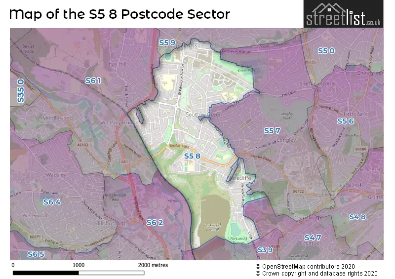
The S5 8 Postcode shares a border with S3 8 (SHEFFIELD), S3 9 (SHEFFIELD), S4 7 (SHEFFIELD), S6 2 (SHEFFIELD), S5 7 (SHEFFIELD), S5 9 (SHEFFIELD) and S6 1 (SHEFFIELD).
The sector is within the post town of SHEFFIELD.
S5 8 is a postcode sector within the S5 postcode district which is within the S Sheffield postcode area.
The Royal Mail delivery office for the S5 8 postal sector is the Sheffield Nepostal Delivery Office.
The area of the S5 8 postcode sector is 1.37 square miles which is 3.55 square kilometres or 876.69 square acres.

Map of the S5 8 Postcode Sector
Explore the S5 8 postcode sector by using our free interactive map.
| S | 5 | - | 8 | X | X |
| S | 5 | Space | 8 | Letter | Letter |
Official List of Streets
SHEFFIELD (109 Streets)
Unofficial Streets or Alternative Spellings
SHEFFIELD
BOYNTON CRESCENT BOYNTON ROAD BROWNING ROAD BUSK PARK CROWDER AVENUE ELM LANE EVERINGHAM CRESCENT EVERINGHAM ROAD FIRSHILL CRESCENT FOX HILL ROAD HOLGATE AVENUE KILNER WAY LINDSAY AVENUE LYMINSTER ROAD MUSGRAVE CRESCENT MUSGRAVE DRIVE PARKWOOD ROAD PENISTONE ROAD NORTH RAISEN HALL ROAD SOUTHEY CRESCENT SOUTHEY RISE TRAFALGAR ROADGrenoside
HALIFAX ROAD BOYNTON ROAD WEST COOKS WOOD ROAD LYTTON COURTWeather Forecast for S5 8
Press Button to Show Forecast for Shirecliffe
| Time Period | Icon | Description | Temperature | Rain Probability | Wind |
|---|---|---|---|---|---|
| 18:00 to 21:00 | Cloudy | 8.0°C (feels like 6.0°C) | 46.00% | NE 7 mph | |
| 21:00 to 00:00 | Cloudy | 5.0°C (feels like 3.0°C) | 47.00% | NNE 4 mph |
Press Button to Show Forecast for Shirecliffe
| Time Period | Icon | Description | Temperature | Rain Probability | Wind |
|---|---|---|---|---|---|
| 00:00 to 03:00 | Partly cloudy (night) | 3.0°C (feels like 1.0°C) | 1.00% | NNE 4 mph | |
| 03:00 to 06:00 | Clear night | 2.0°C (feels like 0.0°C) | 1.00% | NNW 4 mph | |
| 06:00 to 09:00 | Sunny day | 2.0°C (feels like 0.0°C) | 1.00% | NNW 4 mph | |
| 09:00 to 12:00 | Cloudy | 6.0°C (feels like 4.0°C) | 5.00% | ENE 4 mph | |
| 12:00 to 15:00 | Overcast | 8.0°C (feels like 7.0°C) | 9.00% | ENE 4 mph | |
| 15:00 to 18:00 | Cloudy | 9.0°C (feels like 8.0°C) | 7.00% | ENE 4 mph | |
| 18:00 to 21:00 | Cloudy | 7.0°C (feels like 5.0°C) | 12.00% | ENE 7 mph | |
| 21:00 to 00:00 | Cloudy | 4.0°C (feels like 3.0°C) | 8.00% | E 4 mph |
Press Button to Show Forecast for Shirecliffe
| Time Period | Icon | Description | Temperature | Rain Probability | Wind |
|---|---|---|---|---|---|
| 00:00 to 03:00 | Cloudy | 4.0°C (feels like 3.0°C) | 8.00% | ESE 2 mph | |
| 03:00 to 06:00 | Partly cloudy (night) | 3.0°C (feels like 2.0°C) | 9.00% | NNE 4 mph | |
| 06:00 to 09:00 | Cloudy | 4.0°C (feels like 2.0°C) | 11.00% | NNE 4 mph | |
| 09:00 to 12:00 | Cloudy | 7.0°C (feels like 5.0°C) | 11.00% | ENE 7 mph | |
| 12:00 to 15:00 | Overcast | 9.0°C (feels like 6.0°C) | 20.00% | ENE 9 mph | |
| 15:00 to 18:00 | Cloudy | 9.0°C (feels like 7.0°C) | 21.00% | ENE 9 mph | |
| 18:00 to 21:00 | Cloudy | 9.0°C (feels like 6.0°C) | 20.00% | ENE 9 mph | |
| 21:00 to 00:00 | Cloudy | 6.0°C (feels like 3.0°C) | 17.00% | NE 9 mph |
Press Button to Show Forecast for Shirecliffe
| Time Period | Icon | Description | Temperature | Rain Probability | Wind |
|---|---|---|---|---|---|
| 00:00 to 03:00 | Light rain | 5.0°C (feels like 2.0°C) | 50.00% | NNE 9 mph | |
| 03:00 to 06:00 | Light rain | 6.0°C (feels like 2.0°C) | 50.00% | NNE 11 mph | |
| 06:00 to 09:00 | Heavy rain | 6.0°C (feels like 3.0°C) | 77.00% | NNE 11 mph | |
| 09:00 to 12:00 | Heavy rain | 7.0°C (feels like 4.0°C) | 78.00% | NNE 11 mph | |
| 12:00 to 15:00 | Heavy rain | 8.0°C (feels like 6.0°C) | 78.00% | NNE 11 mph | |
| 15:00 to 18:00 | Light rain | 9.0°C (feels like 6.0°C) | 53.00% | NNE 11 mph | |
| 18:00 to 21:00 | Cloudy | 9.0°C (feels like 7.0°C) | 18.00% | N 9 mph | |
| 21:00 to 00:00 | Partly cloudy (night) | 7.0°C (feels like 5.0°C) | 10.00% | SSE 7 mph |
Schools and Places of Education Within the S5 8 Postcode Sector
Chaucer School
Academy sponsor led
Wordsworth Avenue, Sheffield, South Yorkshire, S5 8NH
Head: Mrs Joanna Crewe
Ofsted Rating: Special Measures
Inspection: 2022-06-08 (687 days ago)
Website: Visit Chaucer School Website
Phone: 01142322338
Number of Pupils: 835
Meynell Community Primary School
Academy sponsor led
Meynell Road, Sheffield, South Yorkshire, S5 8GN
Head: Mrs Vikki Garratt
Ofsted Rating: Good
Inspection: 2023-07-04 (296 days ago)
Website: Visit Meynell Community Primary School Website
Phone: 01142311425
Number of Pupils: 472
Oasis Academy Watermead
Academy sponsor led
Barrie Crescent, Sheffield, South Yorkshire, S5 8RJ
Head: Mrs Nichola Smith
Ofsted Rating: Outstanding
Inspection: 2023-09-20 (218 days ago)
Website: Visit Oasis Academy Watermead Website
Phone: 01142016800
Number of Pupils: 426
Parkwood E-ACT Academy
Academy sponsor led
Longley Avenue West, Sheffield, South Yorkshire, S5 8UL
Head: Mrs Gemma Cottingham
Ofsted Rating: Good
Inspection: 2023-03-29 (393 days ago)
Website: Visit Parkwood E-ACT Academy Website
Phone: 01142310221
Number of Pupils: 794
House Prices in the S5 8 Postcode Sector
| Type of Property | 2018 Average | 2018 Sales | 2017 Average | 2017 Sales | 2016 Average | 2016 Sales | 2015 Average | 2015 Sales |
|---|---|---|---|---|---|---|---|---|
| Detached | £175,556 | 9 | £157,598 | 10 | £164,424 | 12 | £164,166 | 12 |
| Semi-Detached | £120,804 | 92 | £112,626 | 83 | £102,775 | 76 | £101,163 | 106 |
| Terraced | £85,854 | 37 | £101,658 | 55 | £76,111 | 38 | £90,448 | 70 |
| Flats | £71,800 | 5 | £70,249 | 4 | £73,500 | 4 | £78,099 | 6 |
Important Postcodes S5 8 in the Postcode Sector
S5 8AL is the postcode for Sheffield City Council, Parsons Cross Park Pavillion, Buchanan Road
S5 8BE is the postcode for Community Health Sheffield NHS Trust, Northlands Community Health Centre, Southey Hill
S5 8BT is the postcode for Adlington Road Community Centre, Adlington Road
S5 8GN is the postcode for Meynell Primary School, Member Of Tapton School Academy Trust, and CHILDRENS CENTRE, Meynell Primary School, Member Of Tapton School Academy Trust
S5 8GS is the postcode for Healthcare Surgery, 63 Palgrave Road
S5 8NH is the postcode for Chaucer Business & Enterprise College, Wordsworth Avenue, and Chaucer School, Member Of Tapton School Academy Trust
S5 8NL is the postcode for THE LEARNING ZONE, 320 WORDSWORTH AVENUE
S5 8RE is the postcode for Sheffield City Council, Moonshine Lane
S5 8RJ is the postcode for Oasis Academy Watermead, Barrie Crescent
S5 8UF is the postcode for Parkwood High School, Penrith Road, and Parkwood Academy, Penrith Road
S5 8UL is the postcode for Parkwood Academy, Longley Avenue West
| The S5 8 Sector is within these Local Authorities |
|
|---|---|
| The S5 8 Sector is within these Counties |
|
| The S5 8 Sector is within these Water Company Areas |
|