The S5 9 postcode sector is within the county of South Yorkshire.
Did you know? According to the 2021 Census, the S5 9 postcode sector is home to a bustling 10,726 residents!
Given that each sector allows for 400 unique postcode combinations. Letters C, I, K, M, O and V are not allowed in the last two letters of a postcode. With 169 postcodes already in use, this leaves 231 units available.
The S5 9 postal code covers the settlement of SHEFFIELD.
The S5 9 Postcode shares a border with S5 0 (SHEFFIELD), S5 7 (SHEFFIELD), S5 8 (SHEFFIELD), S6 1 (SHEFFIELD), S35 8 (Grenoside) and S35 9 (Ecclesfield).
The sector is within the post town of SHEFFIELD.
S5 9 is a postcode sector within the S5 postcode district which is within the S Sheffield postcode area.
The Royal Mail delivery office for the S5 9 postal sector is the Sheffield Nepostal Delivery Office.
The area of the S5 9 postcode sector is 0.94 square miles which is 2.43 square kilometres or 600.45 square acres.

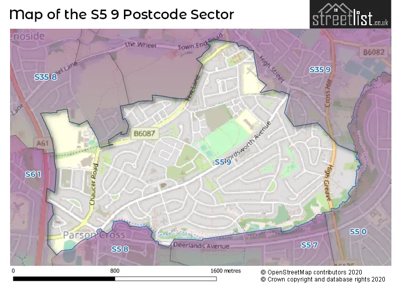
Map of the S5 9 Postcode Sector
Explore the S5 9 postcode sector by using our free interactive map.
| S | 5 | - | 9 | X | X |
| S | 5 | Space | 9 | Letter | Letter |
Official List of Streets
SHEFFIELD (88 Streets)
Unofficial Streets or Alternative Spellings
Weather Forecast for S5 9
Press Button to Show Forecast for Parson Cross
| Time Period | Icon | Description | Temperature | Rain Probability | Wind |
|---|---|---|---|---|---|
| 03:00 to 06:00 | Partly cloudy (night) | 4.0°C (feels like 1.0°C) | 1.00% | NW 7 mph | |
| 06:00 to 09:00 | Cloudy | 5.0°C (feels like 2.0°C) | 3.00% | NNW 7 mph | |
| 09:00 to 12:00 | Cloudy | 7.0°C (feels like 4.0°C) | 4.00% | N 9 mph | |
| 12:00 to 15:00 | Overcast | 9.0°C (feels like 7.0°C) | 8.00% | N 9 mph | |
| 15:00 to 18:00 | Overcast | 10.0°C (feels like 8.0°C) | 7.00% | N 7 mph | |
| 18:00 to 21:00 | Overcast | 10.0°C (feels like 8.0°C) | 7.00% | NNE 7 mph | |
| 21:00 to 00:00 | Cloudy | 7.0°C (feels like 6.0°C) | 4.00% | NE 4 mph |
Press Button to Show Forecast for Parson Cross
| Time Period | Icon | Description | Temperature | Rain Probability | Wind |
|---|---|---|---|---|---|
| 00:00 to 03:00 | Cloudy | 6.0°C (feels like 5.0°C) | 5.00% | NNE 4 mph | |
| 03:00 to 06:00 | Overcast | 6.0°C (feels like 4.0°C) | 12.00% | N 4 mph | |
| 06:00 to 09:00 | Overcast | 5.0°C (feels like 4.0°C) | 18.00% | NNE 4 mph | |
| 09:00 to 12:00 | Overcast | 6.0°C (feels like 5.0°C) | 16.00% | NE 7 mph | |
| 12:00 to 15:00 | Overcast | 8.0°C (feels like 6.0°C) | 16.00% | NE 7 mph | |
| 15:00 to 18:00 | Overcast | 9.0°C (feels like 7.0°C) | 16.00% | NE 7 mph | |
| 18:00 to 21:00 | Cloudy | 8.0°C (feels like 7.0°C) | 11.00% | NE 7 mph | |
| 21:00 to 00:00 | Cloudy | 6.0°C (feels like 5.0°C) | 13.00% | ENE 4 mph |
Press Button to Show Forecast for Parson Cross
| Time Period | Icon | Description | Temperature | Rain Probability | Wind |
|---|---|---|---|---|---|
| 00:00 to 03:00 | Cloudy | 5.0°C (feels like 4.0°C) | 12.00% | NE 4 mph | |
| 03:00 to 06:00 | Overcast | 5.0°C (feels like 3.0°C) | 16.00% | NNW 2 mph | |
| 06:00 to 09:00 | Overcast | 5.0°C (feels like 4.0°C) | 20.00% | NW 4 mph | |
| 09:00 to 12:00 | Light rain | 7.0°C (feels like 5.0°C) | 49.00% | SSE 4 mph | |
| 12:00 to 15:00 | Light rain | 8.0°C (feels like 7.0°C) | 49.00% | SE 4 mph | |
| 15:00 to 18:00 | Light rain | 9.0°C (feels like 8.0°C) | 49.00% | NNE 4 mph | |
| 18:00 to 21:00 | Light rain | 9.0°C (feels like 8.0°C) | 46.00% | NE 7 mph | |
| 21:00 to 00:00 | Overcast | 8.0°C (feels like 7.0°C) | 13.00% | NE 4 mph |
Press Button to Show Forecast for Parson Cross
| Time Period | Icon | Description | Temperature | Rain Probability | Wind |
|---|---|---|---|---|---|
| 00:00 to 03:00 | Overcast | 7.0°C (feels like 6.0°C) | 16.00% | NE 4 mph | |
| 03:00 to 06:00 | Cloudy | 6.0°C (feels like 5.0°C) | 10.00% | N 7 mph | |
| 06:00 to 09:00 | Overcast | 6.0°C (feels like 4.0°C) | 12.00% | NNE 7 mph | |
| 09:00 to 12:00 | Overcast | 8.0°C (feels like 6.0°C) | 9.00% | NE 9 mph | |
| 12:00 to 15:00 | Overcast | 10.0°C (feels like 8.0°C) | 10.00% | NE 9 mph | |
| 15:00 to 18:00 | Cloudy | 11.0°C (feels like 9.0°C) | 8.00% | NNE 9 mph | |
| 18:00 to 21:00 | Partly cloudy (day) | 10.0°C (feels like 7.0°C) | 3.00% | NNE 9 mph | |
| 21:00 to 00:00 | Clear night | 7.0°C (feels like 5.0°C) | 5.00% | NNE 7 mph |
Schools and Places of Education Within the S5 9 Postcode Sector
Mansel Primary
Academy sponsor led
Chaucer Road, Sheffield, South Yorkshire, S5 9QN
Head: Mrs Emily Matthews
Ofsted Rating: Good
Inspection: 2023-03-22 (395 days ago)
Website: Visit Mansel Primary Website
Phone: 01142321278
Number of Pupils: 450
Monteney Primary School
Academy converter
Monteney Crescent, Sheffield, South Yorkshire, S5 9DN
Head: Mrs Nicola Osborne
Ofsted Rating: Good
Inspection: 2023-03-29 (388 days ago)
Website: Visit Monteney Primary School Website
Phone: 01142467916
Number of Pupils: 447
Woolley Wood School
Community special school
Chaucer Road, Sheffield, South Yorkshire, S5 9QN
Head: Mr David Whitehead
Ofsted Rating: Good
Inspection: 2018-11-14 (1984 days ago)
Website: Visit Woolley Wood School Website
Phone: 01142327160
Number of Pupils: 103
House Prices in the S5 9 Postcode Sector
| Type of Property | 2018 Average | 2018 Sales | 2017 Average | 2017 Sales | 2016 Average | 2016 Sales | 2015 Average | 2015 Sales |
|---|---|---|---|---|---|---|---|---|
| Detached | £163,222 | 31 | £151,731 | 16 | £157,468 | 16 | £169,280 | 21 |
| Semi-Detached | £121,452 | 82 | £112,854 | 96 | £111,333 | 86 | £108,350 | 131 |
| Terraced | £109,721 | 27 | £108,017 | 32 | £100,395 | 33 | £90,178 | 28 |
| Flats | £60,000 | 1 | £46,250 | 2 | £58,000 | 2 | £56,350 | 4 |
Important Postcodes S5 9 in the Postcode Sector
S5 9DN is the postcode for Monteney Primary School, Monteney Crescent
S5 9JH is the postcode for Wheata Place Dental Clinic, 570, Wordsworth Avenue
S5 9QN is the postcode for Mansel Primary School & Woolley Wood School, Chaucer Road, Mansel Primary School, Mansel Primary School And Wolley Wood School, Chaucer Road, and MANSEL PRIMARY SCHOOL AND WOLLEY WOOD SCHOOL, CHAUCER ROAD
S5 9QS is the postcode for Mansel Primary School, Mansel Crescent
| The S5 9 Sector is within these Local Authorities |
|
|---|---|
| The S5 9 Sector is within these Counties |
|
| The S5 9 Sector is within these Water Company Areas |
|