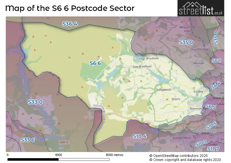
The S6 6 postcode sector stands on the Derbyshire and South Yorkshire border.
Did you know? According to the 2021 Census, the S6 6 postcode sector is home to a bustling 7,881 residents!
Given that each sector allows for 400 unique postcode combinations. Letters C, I, K, M, O and V are not allowed in the last two letters of a postcode. With 192 postcodes already in use, this leaves 208 units available.
The largest settlement in the S6 6 postal code is Stannington followed by Loxley, and Bradfield.
The S6 6 Postcode shares a border with S36 4 (Crow Edge, Stocksbridge, Dunford Bridge), S6 4 (SHEFFIELD), SK13 1 (Hadfield, Tintwistle, Padfield), S6 5 (SHEFFIELD, Rivelin), S10 4 (SHEFFIELD), S32 1 (Hathersage), S33 0 (Bamford) and S35 0 (Oughtibridge, Wharncliffe Side, Worrall).
The sector is within the post town of SHEFFIELD.
S6 6 is a postcode sector within the S6 postcode district which is within the S Sheffield postcode area.
The Royal Mail delivery office for the S6 6 postal sector is the Sheffield Npostal Delivery Office.
The area of the S6 6 postcode sector is 29.85 square miles which is 77.31 square kilometres or 19,102.77 square acres.
Waterways within the S6 6 postcode sector include the River Derwent, River Rivelin, Strines Dike, Abbey Brook, Hobson Moss Dike.

Map of the S6 6 Postcode Sector
Explore the S6 6 postcode sector by using our free interactive map.
| S | 6 | - | 6 | X | X |
| S | 6 | Space | 6 | Letter | Letter |
Official List of Streets
Stannington (82 Streets)
Bradfield (20 Streets)
Loxley (38 Streets)
Hollow Meadows (1 Streets)
SHEFFIELD (2 Streets)
Unofficial Streets or Alternative Spellings
SHEFFIELD
BEN LANE HALL PARK HEAD HALL PARK HILL LIBERTY DRIVE WOOD LANE CLOSE ACORN WAY AGDEN SIDE ROAD ANNET LANE BACK LANE BEETON GREEN BLINDSIDE LANE BROOKSIDE BRIDGE BROOKSIDE LANE BROWN HOUSE LANE CLIFFE HILL CORKER LANE COW GAP LANE CUT GATE DALE CROFT DALE ROAD DELF ROAD DOBB LANE DUKES ROAD FAIR HOUSE LANE FLASH LANE FOULSTONE ROAD GAME LANE HALL LANE HEATHY LANE HILL TOP ROAD HOAR STONES ROAD HOPWOOD LANE HOWDEN EDGE HURKLING EDGE JANE STREET KIRK BRIDGE LAMB HILL LANE HEAD ROAD LEE MOOR LANE LITTLE LANE LOAD FIELD ROAD MILL LEE LANE MILL LEE ROAD MILL WOOD VIEW MOORWOOD LANE MOSCAR CROSS ROAD NETHER HOUSE LANE OAKS LANE OAKS ROAD PACK HORSE BRIDGE PECK HALL LANE PENISTONE ROAD PHILIPS ROAD PLATTS LANE PLUMPTON LANE PUDDING POKE RINGWOOD LANE ROBIN WOOD NATURE TRAIL ROD SIDE ROE GATE ROGER LANE RONKSLEY LANE ROWEL BRIDGE ROWEL LANE SET LANE SHORT LANE SMALLFIELD LANE SMITHY BRIDGE ROAD SPOON LANE STACEY LANE STAKE HILL ROAD STONY LANE STORRS CARR STORRS GREEN STORRS LANE SUGWORTH ROAD THE SANDS THOMPSON HOUSE GREEN THORNSEAT ROAD TINKER BOTTOM TOWNGATE UGHILL ROAD UGHILL WOOD ROAD UPPER GATE ROAD WET SHAW LANE WOOD FALL LANE WOODBANK ROAD WYMING BROOK DRIVE YEWS LANEPenistone
MORTIMER ROADRivelin
MANCHESTER ROADOughtibridge
BURNT HILL LANEWorrall
KIRK EDGE ROADWeather Forecast for S6 6
Press Button to Show Forecast for Low Bradfield
| Time Period | Icon | Description | Temperature | Rain Probability | Wind |
|---|---|---|---|---|---|
| 18:00 to 21:00 | Cloudy | 7.0°C (feels like 5.0°C) | 11.00% | N 7 mph | |
| 21:00 to 00:00 | Cloudy | 4.0°C (feels like 2.0°C) | 33.00% | NNE 4 mph |
Press Button to Show Forecast for Low Bradfield
| Time Period | Icon | Description | Temperature | Rain Probability | Wind |
|---|---|---|---|---|---|
| 00:00 to 03:00 | Partly cloudy (night) | 2.0°C (feels like 1.0°C) | 2.00% | NNE 4 mph | |
| 03:00 to 06:00 | Clear night | 1.0°C (feels like -1.0°C) | 1.00% | NNW 4 mph | |
| 06:00 to 09:00 | Sunny day | 2.0°C (feels like 0.0°C) | 1.00% | NNW 4 mph | |
| 09:00 to 12:00 | Cloudy | 6.0°C (feels like 4.0°C) | 9.00% | NE 4 mph | |
| 12:00 to 15:00 | Overcast | 8.0°C (feels like 7.0°C) | 9.00% | ENE 4 mph | |
| 15:00 to 18:00 | Overcast | 9.0°C (feels like 8.0°C) | 13.00% | ENE 4 mph | |
| 18:00 to 21:00 | Cloudy | 7.0°C (feels like 5.0°C) | 7.00% | E 7 mph | |
| 21:00 to 00:00 | Cloudy | 4.0°C (feels like 2.0°C) | 8.00% | E 4 mph |
Press Button to Show Forecast for Low Bradfield
| Time Period | Icon | Description | Temperature | Rain Probability | Wind |
|---|---|---|---|---|---|
| 00:00 to 03:00 | Cloudy | 4.0°C (feels like 2.0°C) | 8.00% | SSE 2 mph | |
| 03:00 to 06:00 | Partly cloudy (night) | 3.0°C (feels like 1.0°C) | 8.00% | NNE 4 mph | |
| 06:00 to 09:00 | Cloudy | 3.0°C (feels like 2.0°C) | 11.00% | NNE 4 mph | |
| 09:00 to 12:00 | Cloudy | 7.0°C (feels like 4.0°C) | 12.00% | ENE 7 mph | |
| 12:00 to 15:00 | Overcast | 9.0°C (feels like 6.0°C) | 19.00% | ENE 9 mph | |
| 15:00 to 18:00 | Cloudy | 9.0°C (feels like 7.0°C) | 22.00% | E 9 mph | |
| 18:00 to 21:00 | Cloudy | 8.0°C (feels like 6.0°C) | 20.00% | ENE 9 mph | |
| 21:00 to 00:00 | Cloudy | 6.0°C (feels like 3.0°C) | 18.00% | NE 9 mph |
Press Button to Show Forecast for Low Bradfield
| Time Period | Icon | Description | Temperature | Rain Probability | Wind |
|---|---|---|---|---|---|
| 00:00 to 03:00 | Light rain | 5.0°C (feels like 2.0°C) | 51.00% | NNE 9 mph | |
| 03:00 to 06:00 | Light rain | 6.0°C (feels like 2.0°C) | 51.00% | NNE 11 mph | |
| 06:00 to 09:00 | Heavy rain | 6.0°C (feels like 3.0°C) | 76.00% | NNE 11 mph | |
| 09:00 to 12:00 | Heavy rain | 7.0°C (feels like 4.0°C) | 79.00% | NNE 11 mph | |
| 12:00 to 15:00 | Heavy rain | 8.0°C (feels like 5.0°C) | 77.00% | N 11 mph | |
| 15:00 to 18:00 | Light rain | 9.0°C (feels like 6.0°C) | 54.00% | N 11 mph | |
| 18:00 to 21:00 | Light rain shower (day) | 9.0°C (feels like 6.0°C) | 36.00% | N 9 mph | |
| 21:00 to 00:00 | Partly cloudy (night) | 7.0°C (feels like 5.0°C) | 11.00% | SE 7 mph |
Schools and Places of Education Within the S6 6 Postcode Sector
Bradfield Dungworth Primary School
Academy converter
Dungworth Green, Sheffield, South Yorkshire, S6 6HE
Head: Mr Liam Mitchell
Ofsted Rating: Good
Inspection: 2023-05-04 (357 days ago)
Website: Visit Bradfield Dungworth Primary School Website
Phone: 01142851338
Number of Pupils: 136
Nook Lane Junior School
Academy converter
Nook Lane, Sheffield, South Yorkshire, S6 6BN
Head: Mr Steven Arbon-Davis
Ofsted Rating: Good
Inspection: 2023-10-19 (189 days ago)
Website: Visit Nook Lane Junior School Website
Phone: 01142341097
Number of Pupils: 242
Stannington Infant School
Academy converter
Stannington Road, Sheffield, South Yorkshire, S6 6AN
Head: Mrs Sarah Binns
Ofsted Rating: Outstanding
Inspection: 2023-12-14 (133 days ago)
Website: Visit Stannington Infant School Website
Phone: 01142344401
Number of Pupils: 180
House Prices in the S6 6 Postcode Sector
| Type of Property | 2018 Average | 2018 Sales | 2017 Average | 2017 Sales | 2016 Average | 2016 Sales | 2015 Average | 2015 Sales |
|---|---|---|---|---|---|---|---|---|
| Detached | £384,768 | 68 | £294,246 | 52 | £320,819 | 34 | £286,653 | 33 |
| Semi-Detached | £241,585 | 33 | £239,105 | 40 | £210,734 | 32 | £217,462 | 41 |
| Terraced | £212,881 | 21 | £196,785 | 13 | £204,967 | 24 | £241,211 | 23 |
| Flats | £141,575 | 10 | £126,250 | 4 | £169,990 | 5 | £134,500 | 3 |
Important Postcodes S6 6 in the Postcode Sector
S6 6AN is the postcode for Stannington Infant School, Stannington Road
S6 6BN is the postcode for Nook Lane Junior School, Nook Lane
S6 6HE is the postcode for Bradfield Dungworth Primary School, Dungworth Green
S6 6SG is the postcode for Loxley Primary School, Rodney Hill
| The S6 6 Sector is within these Local Authorities |
|
|---|---|
| The S6 6 Sector is within these Counties |
|
| The S6 6 Sector is within these Water Company Areas |
|