The S60 postcode district is a postal district located in the S Sheffield postcode area with a population of 42,125 residents according to the 2021 England and Wales Census.
The area of the S60 postcode district is 11.23 square miles which is 29.08 square kilometres or 7,186.11 acres.
Currently, the S60 district has about 1037 postcode units spread across 5 geographic postcode sectors.
Given that each sector allows for 400 unique postcode combinations, the district has a capacity of 2,000 postcodes. With 1037 postcodes already in use, this leaves 963 units available.
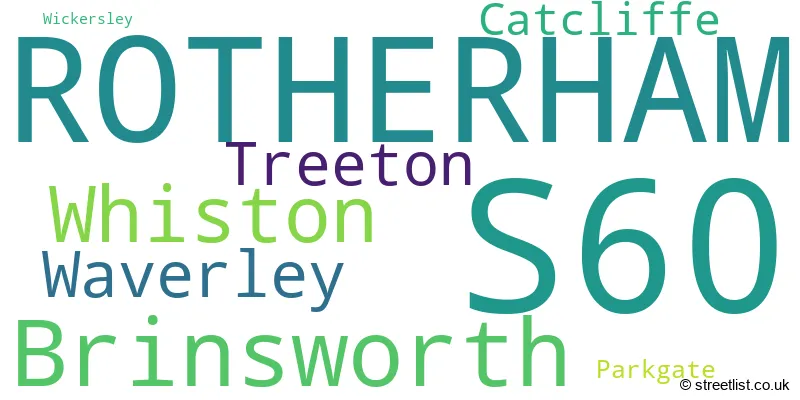
The largest settlement in the S60 postal code is ROTHERHAM followed by Brinsworth, and Whiston.
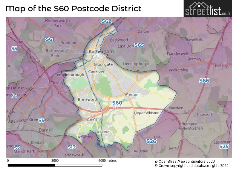
The S60 Postcode shares a border with S13 (SHEFFIELD, Woodhouse, Handsworth), S26 (Swallownest, Aston, Kiveton Park), S9 (SHEFFIELD, Tinsley), S61 (ROTHERHAM, Thorpe Hesley, Scholes) and S65 (ROTHERHAM, Thrybergh, Ravenfield).
The primary settlement in the S60 postcode district is Rotherham, which is located in the county of South Yorkshire. Other significant settlements within the district include Parkgate, Whiston, Wickersley, Brinsworth, Catcliffe, and Treeton. The most significant post town in the district is also Rotherham.
For the district S60, we have data on 7 postcode sectors. Here's a breakdown: The sector S60 1, covers Rotherham in South Yorkshire. The sector S60 2, covers Rotherham in South Yorkshire. The sector S60 3, covers Rotherham in South Yorkshire. The sector S60 4, covers Whiston and Rotherham in South Yorkshire. The sector S60 5, covers Brinsworth and Treeton and Catcliffe in South Yorkshire. The sector S60 8 is non-geographic. It's often designated for PO Boxes, large organisations, or special services. The sector S60 9 is non-geographic. It's often designated for PO Boxes, large organisations, or special services.

Map of the S60 Postcode District
Explore the S60 postcode district by using our free interactive map.
When it comes to local government, postal geography often disregards political borders. However, for a breakdown in the S60 District: the district mostly encompasses the Rotherham District (B) area with a total of 1075 postcodes.
Recent House Sales in S60
| Date | Price | Address |
|---|---|---|
| 29/09/2023 | £230,000 | Tissington Drive, Waverley, Rotherham, S60 8AP |
| 29/09/2023 | £193,000 | Broom Grove, Rotherham, S60 2TE |
| 21/09/2023 | £290,000 | Moorhouse Lane, Whiston, Rotherham, S60 4NH |
| 15/09/2023 | £166,000 | Townend Close, Treeton, Rotherham, S60 5PQ |
| 15/09/2023 | £150,000 | Sunnybank Crescent, Brinsworth, Rotherham, S60 5JJ |
| 13/09/2023 | £200,000 | Gerard Road, Rotherham, S60 2PP |
| 11/09/2023 | £190,000 | Anson Grove, Brinsworth, Rotherham, S60 5PG |
| 11/09/2023 | £276,000 | Fairleigh Drive, Rotherham, S60 2AX |
| 08/09/2023 | £275,000 | Grange Road, Rotherham, S60 3LH |
| 08/09/2023 | £68,750 | Reneville Road, Rotherham, S60 2AN |
Weather Forecast for S60
Press Button to Show Forecast for Canklow
| Time Period | Icon | Description | Temperature | Rain Probability | Wind |
|---|---|---|---|---|---|
| 21:00 to 00:00 | Cloudy | 5.0°C (feels like 3.0°C) | 5.00% | NE 7 mph |
Press Button to Show Forecast for Canklow
| Time Period | Icon | Description | Temperature | Rain Probability | Wind |
|---|---|---|---|---|---|
| 00:00 to 03:00 | Partly cloudy (night) | 3.0°C (feels like 2.0°C) | 1.00% | NNE 2 mph | |
| 03:00 to 06:00 | Clear night | 2.0°C (feels like 0.0°C) | 1.00% | NNW 4 mph | |
| 06:00 to 09:00 | Sunny day | 3.0°C (feels like 0.0°C) | 1.00% | NNW 4 mph | |
| 09:00 to 12:00 | Cloudy | 7.0°C (feels like 5.0°C) | 6.00% | NE 4 mph | |
| 12:00 to 15:00 | Overcast | 9.0°C (feels like 8.0°C) | 10.00% | ENE 4 mph | |
| 15:00 to 18:00 | Cloudy | 9.0°C (feels like 8.0°C) | 11.00% | ENE 4 mph | |
| 18:00 to 21:00 | Cloudy | 7.0°C (feels like 5.0°C) | 9.00% | E 7 mph | |
| 21:00 to 00:00 | Partly cloudy (night) | 5.0°C (feels like 4.0°C) | 6.00% | NE 4 mph |
Press Button to Show Forecast for Canklow
| Time Period | Icon | Description | Temperature | Rain Probability | Wind |
|---|---|---|---|---|---|
| 00:00 to 03:00 | Cloudy | 4.0°C (feels like 3.0°C) | 9.00% | NE 4 mph | |
| 03:00 to 06:00 | Cloudy | 3.0°C (feels like 1.0°C) | 10.00% | NNE 4 mph | |
| 06:00 to 09:00 | Cloudy | 4.0°C (feels like 2.0°C) | 10.00% | NNE 4 mph | |
| 09:00 to 12:00 | Cloudy | 8.0°C (feels like 6.0°C) | 11.00% | ENE 7 mph | |
| 12:00 to 15:00 | Overcast | 10.0°C (feels like 8.0°C) | 21.00% | E 9 mph | |
| 15:00 to 18:00 | Cloudy | 10.0°C (feels like 8.0°C) | 19.00% | ENE 9 mph | |
| 18:00 to 21:00 | Cloudy | 9.0°C (feels like 7.0°C) | 17.00% | ENE 9 mph | |
| 21:00 to 00:00 | Cloudy | 7.0°C (feels like 4.0°C) | 15.00% | NE 9 mph |
Press Button to Show Forecast for Canklow
| Time Period | Icon | Description | Temperature | Rain Probability | Wind |
|---|---|---|---|---|---|
| 00:00 to 03:00 | Overcast | 6.0°C (feels like 3.0°C) | 21.00% | NNE 9 mph | |
| 03:00 to 06:00 | Light rain | 6.0°C (feels like 3.0°C) | 50.00% | NNE 11 mph | |
| 06:00 to 09:00 | Heavy rain | 7.0°C (feels like 4.0°C) | 77.00% | NNE 11 mph | |
| 09:00 to 12:00 | Heavy rain | 8.0°C (feels like 5.0°C) | 78.00% | NNE 11 mph | |
| 12:00 to 15:00 | Heavy rain | 10.0°C (feels like 7.0°C) | 78.00% | NNE 11 mph | |
| 15:00 to 18:00 | Light rain | 10.0°C (feels like 7.0°C) | 50.00% | NNW 11 mph | |
| 18:00 to 21:00 | Overcast | 9.0°C (feels like 7.0°C) | 21.00% | N 9 mph | |
| 21:00 to 00:00 | Partly cloudy (night) | 7.0°C (feels like 5.0°C) | 8.00% | SSE 7 mph |
Where is the S60 Postcode District?
The postcode district for S60 is located in Rotherham. It is a district town situated near various towns in different directions. Some of the nearby towns include Mexborough to the North East, Sheffield to the West, Dronfield to the South West, Barnsley to the North West, Worksop to the South East, Chesterfield to the South, Pontefract to the North, and Retford to the East. Additionally, the distance from S60 to the center of London is approximately 140.87 miles.
The district is within the post town of ROTHERHAM.
The sector has postcodes within the nation of England.
The S60 Postcode District is in the Barnsley, Doncaster and Rotherham region of South Yorkshire within the Yorkshire and The Humber.
| Postcode Sector | Delivery Office |
|---|---|
| S60 1 | Rotherham Delivery Office |
| S60 2 | Rotherham Delivery Office |
| S60 3 | Rotherham Delivery Office |
| S60 4 | Rotherham Delivery Office |
| S60 5 | Rotherham Delivery Office |
| S | 6 | 0 | - | X | X | X |
| S | 6 | 0 | Space | Numeric | Letter | Letter |
Current Monthly Rental Prices
| # Bedrooms | Min Price | Max Price | Avg Price |
|---|---|---|---|
| 1 | £412 | £650 | £570 |
| 2 | £725 | £725 | £725 |
| 3 | £850 | £1,250 | £1,034 |
| 4 | £1,000 | £1,000 | £1,000 |
Current House Prices
| # Bedrooms | Min Price | Max Price | Avg Price |
|---|---|---|---|
| £55,000 | £325,000 | £190,000 | |
| 1 | £60,000 | £100,950 | £71,488 |
| 2 | £30,000 | £275,000 | £130,661 |
| 3 | £60,000 | £695,000 | £244,391 |
| 4 | £65,000 | £700,000 | £369,281 |
| 5 | £170,000 | £1,100,000 | £452,444 |
| 6 | £500,000 | £500,000 | £500,000 |
Estate Agents who Operate in the S60 District
| Logo | Name | Brand Name | Address | Contact Number | Total Properties |
|---|---|---|---|---|---|
 | Rotherham | William H. Brown | 32 Mansfield Road, Rotherham, S60 2DR | 01709 212549 | 24 |
 | Rotherham | Uflit | 29 Brinsworth Lane Brinsworth Rotherham S60 5BS | 01709 212514 | 15 |
 | Sheffield | 2Roost | 27 Main Street, Swallownest, Sheffield, S26 4TZ | 0114 287 8696 | 14 |
 | Rotherham | Bartons | 51 - 53 Moorgate Street Rotherham S60 2EY | 01709 212542 | 11 |
 | Wickersley | Crucible Homes | 234 Bawtry Road Wickersley Rotherham S66 1AA | 01709 300333 | 11 |
| Type of Property | 2018 Average | 2018 Sales | 2017 Average | 2017 Sales | 2016 Average | 2016 Sales | 2015 Average | 2015 Sales |
|---|---|---|---|---|---|---|---|---|
| Detached | £279,654 | 155 | £252,273 | 136 | £255,872 | 220 | £246,503 | 224 |
| Semi-Detached | £157,591 | 285 | £145,687 | 299 | £148,627 | 360 | £147,212 | 366 |
| Terraced | £140,137 | 115 | £127,698 | 108 | £117,654 | 85 | £117,268 | 77 |
| Flats | £121,223 | 28 | £117,472 | 71 | £96,031 | 31 | £99,098 | 33 |