The S8 9 postcode sector is within the county of South Yorkshire.
Did you know? According to the 2021 Census, the S8 9 postcode sector is home to a bustling 9,267 residents!
Given that each sector allows for 400 unique postcode combinations. Letters C, I, K, M, O and V are not allowed in the last two letters of a postcode. With 174 postcodes already in use, this leaves 226 units available.
The S8 9 postal code covers the settlement of SHEFFIELD.
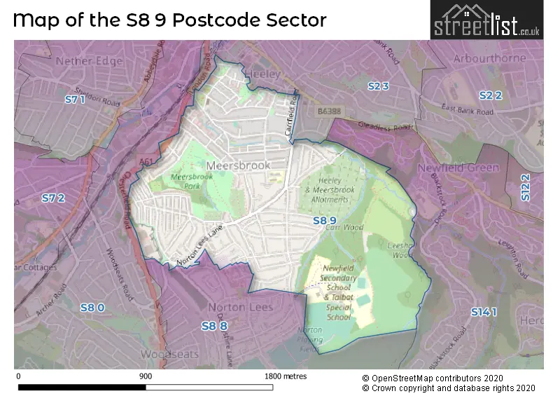
The S8 9 Postcode shares a border with S2 3 (SHEFFIELD, Heeley), S2 4 (SHEFFIELD), S8 0 (SHEFFIELD), S8 8 (SHEFFIELD) and S14 1 (SHEFFIELD).
The sector is within the post town of SHEFFIELD.
S8 9 is a postcode sector within the S8 postcode district which is within the S Sheffield postcode area.
The Royal Mail delivery office for the S8 9 postal sector is the Sheffield Scale Payment Delivery Office.
The area of the S8 9 postcode sector is 0.94 square miles which is 2.43 square kilometres or 600.71 square acres.
Waterways within the S8 9 postcode sector include the Meers Brook.

Map of the S8 9 Postcode Sector
Explore the S8 9 postcode sector by using our free interactive map.
| S | 8 | - | 9 | X | X |
| S | 8 | Space | 9 | Letter | Letter |
Official List of Streets
SHEFFIELD (95 Streets)
Unofficial Streets or Alternative Spellings
Weather Forecast for S8 9
Press Button to Show Forecast for Heeley
| Time Period | Icon | Description | Temperature | Rain Probability | Wind |
|---|---|---|---|---|---|
| 06:00 to 09:00 | Partly cloudy (day) | 5.0°C (feels like 2.0°C) | 0.00% | WSW 9 mph | |
| 09:00 to 12:00 | Light rain | 7.0°C (feels like 4.0°C) | 43.00% | NW 9 mph | |
| 12:00 to 15:00 | Cloudy | 6.0°C (feels like 4.0°C) | 45.00% | N 9 mph | |
| 15:00 to 18:00 | Cloudy | 8.0°C (feels like 7.0°C) | 8.00% | NNE 4 mph | |
| 18:00 to 21:00 | Cloudy | 8.0°C (feels like 6.0°C) | 12.00% | NE 7 mph | |
| 21:00 to 00:00 | Cloudy | 5.0°C (feels like 3.0°C) | 10.00% | NNE 4 mph |
Press Button to Show Forecast for Heeley
| Time Period | Icon | Description | Temperature | Rain Probability | Wind |
|---|---|---|---|---|---|
| 00:00 to 03:00 | Cloudy | 4.0°C (feels like 2.0°C) | 5.00% | ENE 4 mph | |
| 03:00 to 06:00 | Partly cloudy (night) | 3.0°C (feels like 1.0°C) | 1.00% | N 4 mph | |
| 06:00 to 09:00 | Partly cloudy (day) | 3.0°C (feels like 0.0°C) | 1.00% | N 4 mph | |
| 09:00 to 12:00 | Cloudy | 6.0°C (feels like 4.0°C) | 4.00% | NE 7 mph | |
| 12:00 to 15:00 | Overcast | 8.0°C (feels like 7.0°C) | 10.00% | ENE 4 mph | |
| 15:00 to 18:00 | Cloudy | 9.0°C (feels like 8.0°C) | 7.00% | ENE 4 mph | |
| 18:00 to 21:00 | Cloudy | 7.0°C (feels like 5.0°C) | 10.00% | ENE 7 mph | |
| 21:00 to 00:00 | Cloudy | 5.0°C (feels like 3.0°C) | 7.00% | ENE 7 mph |
Press Button to Show Forecast for Heeley
| Time Period | Icon | Description | Temperature | Rain Probability | Wind |
|---|---|---|---|---|---|
| 00:00 to 03:00 | Cloudy | 4.0°C (feels like 2.0°C) | 8.00% | NE 4 mph | |
| 03:00 to 06:00 | Cloudy | 3.0°C (feels like 1.0°C) | 9.00% | NE 4 mph | |
| 06:00 to 09:00 | Partly cloudy (day) | 4.0°C (feels like 1.0°C) | 8.00% | NE 7 mph | |
| 09:00 to 12:00 | Cloudy | 7.0°C (feels like 5.0°C) | 11.00% | ENE 9 mph | |
| 12:00 to 15:00 | Cloudy | 9.0°C (feels like 7.0°C) | 18.00% | ENE 9 mph | |
| 15:00 to 18:00 | Overcast | 10.0°C (feels like 8.0°C) | 20.00% | ENE 11 mph | |
| 18:00 to 21:00 | Cloudy | 9.0°C (feels like 6.0°C) | 18.00% | ENE 11 mph | |
| 21:00 to 00:00 | Cloudy | 7.0°C (feels like 4.0°C) | 16.00% | NE 11 mph |
Press Button to Show Forecast for Heeley
| Time Period | Icon | Description | Temperature | Rain Probability | Wind |
|---|---|---|---|---|---|
| 00:00 to 03:00 | Cloudy | 6.0°C (feels like 3.0°C) | 22.00% | NE 11 mph | |
| 03:00 to 06:00 | Light rain | 6.0°C (feels like 3.0°C) | 51.00% | NNE 13 mph | |
| 06:00 to 09:00 | Heavy rain | 7.0°C (feels like 3.0°C) | 77.00% | NNE 13 mph | |
| 09:00 to 12:00 | Heavy rain | 8.0°C (feels like 5.0°C) | 77.00% | NNE 13 mph | |
| 12:00 to 15:00 | Heavy rain | 10.0°C (feels like 7.0°C) | 78.00% | NNE 13 mph | |
| 15:00 to 18:00 | Light rain shower (day) | 10.0°C (feels like 7.0°C) | 42.00% | NNW 11 mph | |
| 18:00 to 21:00 | Overcast | 9.0°C (feels like 7.0°C) | 21.00% | NW 9 mph | |
| 21:00 to 00:00 | Partly cloudy (night) | 8.0°C (feels like 6.0°C) | 9.00% | SSE 7 mph |
Schools and Places of Education Within the S8 9 Postcode Sector
Carfield Primary School
Community school
Argyle Close, Sheffield, South Yorkshire, S8 9HJ
Head: Mrs Hannan Mohammed
Ofsted Rating: Requires improvement
Inspection: 2023-04-20 (371 days ago)
Website: Visit Carfield Primary School Website
Phone: 01142557534
Number of Pupils: 612
Meersbrook Bank Primary School
Community school
Derbyshire Lane, Sheffield, South Yorkshire, S8 9EH
Head: Mrs Gemma Harvey
Ofsted Rating: Good
Inspection: 2022-07-06 (659 days ago)
Website: Visit Meersbrook Bank Primary School Website
Phone: 01142814423
Number of Pupils: 238
Newfield Secondary School
Academy sponsor led
Lees Hall Road, Sheffield, South Yorkshire, S8 9JP
Head: Mrs Emma Anderson
Ofsted Rating: Good
Inspection: 2022-03-18 (769 days ago)
Website: Visit Newfield Secondary School Website
Phone: 01142557331
Number of Pupils: 1046
Talbot Specialist School
Community special school
Lees Hall Road, Sheffield, South Yorkshire, S8 9JP
Head: Mrs Heather Partington
Ofsted Rating: Good
Inspection: 2022-06-29 (666 days ago)
Website: Visit Talbot Specialist School Website
Phone: 01142507394
Number of Pupils: 217
House Prices in the S8 9 Postcode Sector
| Type of Property | 2018 Average | 2018 Sales | 2017 Average | 2017 Sales | 2016 Average | 2016 Sales | 2015 Average | 2015 Sales |
|---|---|---|---|---|---|---|---|---|
| Detached | £288,188 | 8 | £218,792 | 12 | £246,933 | 9 | £232,086 | 12 |
| Semi-Detached | £224,786 | 45 | £208,810 | 89 | £187,380 | 73 | £175,600 | 73 |
| Terraced | £172,589 | 75 | £165,190 | 79 | £147,537 | 72 | £138,093 | 96 |
| Flats | £86,550 | 10 | £96,889 | 18 | £92,132 | 17 | £93,203 | 15 |
Important Postcodes S8 9 in the Postcode Sector
S8 9BE is the postcode for Bishops House Museum, Norton Lees Lane
S8 9EH is the postcode for MEERSBROOK BANK PRIMARY SCHOOL, DERBYSHIRE LANE, SHEFFIELD, Meersbrook Bank Primary School, Derbyshire Lane, NURSERY BLOCK B, Meersbrook Bank Primary School, Derbyshire Lane, and MAIN SCHOOL BLOCK A, Meersbrook Bank Primary School, Derbyshire Lane
S8 9FH is the postcode for Meersbrook Offices, Brook Road
S8 9HJ is the postcode for BLOCK A, Carfield Primary School, Argyle Road, BLOCK B, Carfield Primary School, Argyle Road, and Carfield Primary School, Argyle Road
S8 9JP is the postcode for Talbot School, Lees Hall Road, Newfield School, Lees Hall Road, and NEWFIELD SCHOOL, LEES HALL ROAD, SHEFFIELD
| The S8 9 Sector is within these Local Authorities |
|
|---|---|
| The S8 9 Sector is within these Counties |
|
| The S8 9 Sector is within these Water Company Areas |
|