The S81 postcode district is a postal district located in the S Sheffield postcode area with a population of 38,656 residents according to the 2021 England and Wales Census.
The area of the S81 postcode district is 39.97 square miles which is 103.51 square kilometres or 25,578.75 acres.
Currently, the S81 district has about 1032 postcode units spread across 4 geographic postcode sectors.
Given that each sector allows for 400 unique postcode combinations, the district has a capacity of 1,600 postcodes. With 1032 postcodes already in use, this leaves 568 units available.
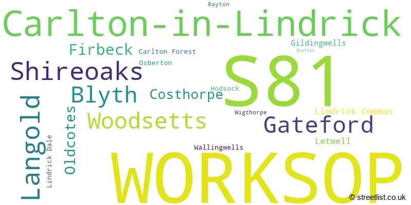
The largest settlement in the S81 postal code is WORKSOP followed by Carlton-in-Lindrick, and Langold.
The S81 Postcode shares a border with S25 (Dinnington, North Anston, South Anston), DN11 (New Rossington, Harworth, Tickhill), S80 (WORKSOP, Creswell, Whitwell), DN22 (RETFORD, Ranskill, Clarborough) and S66 (Maltby, Wickersley, Bramley).
The primary settlement in the S81 postcode district is Worksop, located in the county of Nottinghamshire in England. Other significant settlements in the district include Blyth, Carlton Forest, Hodsock, Osberton, Rayton, and Scofton.
For the district S81, we have data on 4 postcode sectors. Here's a breakdown: The sector S81 0, covers Worksop in Nottinghamshire. The sector S81 7, covers Worksop in Nottinghamshire. The sector S81 8, covers Shireoaks and Gateford and Blyth in Nottinghamshire. The sector S81 8, covers Woodsetts in South Yorkshire. The sector S81 9, covers Carlton-In-Lindrick and Langold in Nottinghamshire.

Map of the S81 Postcode District
Explore the S81 postcode district by using our free interactive map.
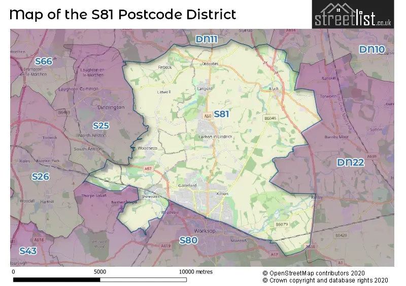
When it comes to local government, postal geography often disregards political borders. However, for a breakdown in the S81 District: the district mostly encompasses the Bassetlaw District (993 postcodes), and finally, the Rotherham District (B) area (92 postcodes).
Recent House Sales in S81
| Date | Price | Address |
|---|---|---|
| 10/10/2023 | £150,000 | Cowper Close, Worksop, S81 0RQ |
| 04/10/2023 | £195,000 | Church Lane, Carlton In Lindrick, Worksop, S81 9EH |
| 29/09/2023 | £150,000 | Carnoustie, Worksop, S81 0DB |
| 22/09/2023 | £570,000 | Park Hill Drive, Firbeck, Worksop, S81 8LA |
| 15/09/2023 | £159,000 | Coniston Road, Worksop, S81 7PP |
| 08/09/2023 | £206,000 | South Parade, Worksop, S81 0BU |
| 08/09/2023 | £225,000 | Carlton Road, Worksop, S81 7LR |
| 08/09/2023 | £155,000 | Lindrick Road, Woodsetts, Worksop, S81 8RD |
| 05/09/2023 | £370,000 | Retford Road, Blyth, Worksop, S81 8EY |
| 01/09/2023 | £420,000 | Blyth Road, Worksop, S81 0HP |
Weather Forecast for S81
Press Button to Show Forecast for North Carlton
| Time Period | Icon | Description | Temperature | Rain Probability | Wind |
|---|---|---|---|---|---|
| 12:00 to 15:00 | Cloudy | 9.0°C (feels like 7.0°C) | 10.00% | N 11 mph | |
| 15:00 to 18:00 | Cloudy | 10.0°C (feels like 7.0°C) | 4.00% | N 13 mph | |
| 18:00 to 21:00 | Cloudy | 8.0°C (feels like 6.0°C) | 4.00% | N 11 mph | |
| 21:00 to 00:00 | Cloudy | 6.0°C (feels like 4.0°C) | 4.00% | N 7 mph |
Press Button to Show Forecast for North Carlton
| Time Period | Icon | Description | Temperature | Rain Probability | Wind |
|---|---|---|---|---|---|
| 00:00 to 03:00 | Clear night | 5.0°C (feels like 2.0°C) | 1.00% | NNW 9 mph | |
| 03:00 to 06:00 | Partly cloudy (night) | 5.0°C (feels like 1.0°C) | 1.00% | NNW 9 mph | |
| 06:00 to 09:00 | Partly cloudy (day) | 4.0°C (feels like 1.0°C) | 1.00% | NNW 9 mph | |
| 09:00 to 12:00 | Cloudy | 6.0°C (feels like 3.0°C) | 8.00% | NNW 11 mph | |
| 12:00 to 15:00 | Cloudy | 9.0°C (feels like 6.0°C) | 5.00% | N 11 mph | |
| 15:00 to 18:00 | Cloudy | 10.0°C (feels like 7.0°C) | 4.00% | N 11 mph | |
| 18:00 to 21:00 | Cloudy | 8.0°C (feels like 6.0°C) | 3.00% | NNE 7 mph | |
| 21:00 to 00:00 | Cloudy | 5.0°C (feels like 4.0°C) | 4.00% | ENE 4 mph |
Press Button to Show Forecast for North Carlton
| Time Period | Icon | Description | Temperature | Rain Probability | Wind |
|---|---|---|---|---|---|
| 00:00 to 03:00 | Cloudy | 5.0°C (feels like 2.0°C) | 4.00% | WSW 7 mph | |
| 03:00 to 06:00 | Cloudy | 5.0°C (feels like 1.0°C) | 4.00% | W 9 mph | |
| 06:00 to 09:00 | Cloudy | 5.0°C (feels like 2.0°C) | 6.00% | W 9 mph | |
| 09:00 to 12:00 | Cloudy | 8.0°C (feels like 6.0°C) | 8.00% | NW 11 mph | |
| 12:00 to 15:00 | Cloudy | 10.0°C (feels like 7.0°C) | 8.00% | NNW 11 mph | |
| 15:00 to 18:00 | Cloudy | 9.0°C (feels like 7.0°C) | 10.00% | N 9 mph | |
| 18:00 to 21:00 | Cloudy | 8.0°C (feels like 6.0°C) | 8.00% | NNE 7 mph | |
| 21:00 to 00:00 | Cloudy | 5.0°C (feels like 3.0°C) | 5.00% | NE 4 mph |
Press Button to Show Forecast for North Carlton
| Time Period | Icon | Description | Temperature | Rain Probability | Wind |
|---|---|---|---|---|---|
| 00:00 to 03:00 | Cloudy | 3.0°C (feels like 1.0°C) | 5.00% | E 4 mph | |
| 03:00 to 06:00 | Cloudy | 2.0°C (feels like 0.0°C) | 4.00% | NE 2 mph | |
| 06:00 to 09:00 | Cloudy | 3.0°C (feels like 2.0°C) | 6.00% | NE 4 mph | |
| 09:00 to 12:00 | Cloudy | 7.0°C (feels like 5.0°C) | 7.00% | E 4 mph | |
| 12:00 to 15:00 | Overcast | 9.0°C (feels like 7.0°C) | 12.00% | ESE 7 mph | |
| 15:00 to 18:00 | Overcast | 10.0°C (feels like 8.0°C) | 14.00% | ESE 7 mph | |
| 18:00 to 21:00 | Cloudy | 9.0°C (feels like 7.0°C) | 11.00% | ESE 9 mph | |
| 21:00 to 00:00 | Cloudy | 6.0°C (feels like 4.0°C) | 9.00% | E 7 mph |
Press Button to Show Forecast for North Carlton
| Time Period | Icon | Description | Temperature | Rain Probability | Wind |
|---|---|---|---|---|---|
| 00:00 to 03:00 | Cloudy | 6.0°C (feels like 3.0°C) | 12.00% | E 7 mph | |
| 03:00 to 06:00 | Cloudy | 5.0°C (feels like 3.0°C) | 16.00% | E 7 mph | |
| 06:00 to 09:00 | Cloudy | 6.0°C (feels like 3.0°C) | 16.00% | E 7 mph | |
| 09:00 to 12:00 | Cloudy | 9.0°C (feels like 6.0°C) | 15.00% | ENE 9 mph | |
| 12:00 to 15:00 | Cloudy | 11.0°C (feels like 9.0°C) | 15.00% | E 9 mph | |
| 15:00 to 18:00 | Light rain | 11.0°C (feels like 9.0°C) | 57.00% | E 9 mph | |
| 18:00 to 21:00 | Cloudy | 10.0°C (feels like 8.0°C) | 13.00% | ENE 9 mph | |
| 21:00 to 00:00 | Cloudy | 8.0°C (feels like 6.0°C) | 13.00% | ENE 9 mph |
Where is the S81 Postcode District?
The data provided states that the postcode district for S81 is located in Worksop. Worksop is a town in the district. It is situated near several other towns, including Retford to the East (8.45 miles), Rotherham to the North West (10.28 miles), Doncaster to the North (11.30 miles), Chesterfield to the South West (14.60 miles), Mansfield to the South (15.14 miles), and Dronfield to the West (15.26 miles). Additionally, Worksop is approximately 134.05 miles away from the center of London.
The district is within the post town of WORKSOP.
The sector has postcodes within the nation of England.
The S81 Postcode District is covers the following regions.
- North Nottinghamshire - Derbyshire and Nottinghamshire - East Midlands (England)
- Barnsley, Doncaster and Rotherham - South Yorkshire - Yorkshire and The Humber
| Postcode Sector | Delivery Office |
|---|---|
| S81 0 | Worksop Delivery Office |
| S81 7 | Worksop Delivery Office |
| S81 8 | Worksop Delivery Office |
| S81 9 | Worksop Delivery Office |
| S81 9 | Carlton-in-lindrick Scale Payment Delivery Office |
| S | 8 | 1 | - | X | X | X |
| S | 8 | 1 | Space | Numeric | Letter | Letter |
Tourist Attractions within the Postcode Area
We found 3 visitor attractions within the S81 postcode area
| Mr Straw's House |
|---|
| Historic Properties |
| Historic House / House and Garden / Palace |
| View Mr Straw's House on Google Maps |
| Hodsock Priory Gardens |
| Historic Properties |
| Historic House / House and Garden / Palace |
| View Hodsock Priory Gardens on Google Maps |
| Hodsock Snowdrops |
| Historic Properties |
| Historic House / House and Garden / Palace |
| View Hodsock Snowdrops on Google Maps |
Current Monthly Rental Prices
| # Bedrooms | Min Price | Max Price | Avg Price |
|---|---|---|---|
| £425 | £425 | £425 | |
| 1 | £575 | £575 | £575 |
| 2 | £595 | £800 | £698 |
| 3 | £750 | £1,400 | £987 |
| 4 | £1,350 | £1,350 | £1,350 |
Current House Prices
| # Bedrooms | Min Price | Max Price | Avg Price |
|---|---|---|---|
| £175,000 | £320,000 | £247,500 | |
| 1 | £40,000 | £250,000 | £126,667 |
| 2 | £79,498 | £500,000 | £245,878 |
| 3 | £60,000 | £700,000 | £246,084 |
| 4 | £180,000 | £900,000 | £374,633 |
| 5 | £290,000 | £1,000,000 | £472,799 |
| 6 | £350,000 | £350,000 | £350,000 |
Estate Agents who Operate in the S81 District
| Logo | Name | Brand Name | Address | Contact Number | Total Properties |
|---|---|---|---|---|---|
 | Worksop | William H. Brown | 80 Bridge Street, Worksop, S80 1JA | 01909 490418 | 42 |
 | Worksop | Burrell's Estate Agency | 58 Bridge Street, Worksop, S80 1JA | 01909 490420 | 24 |
 | Worksop | Mellor & Beer | 51 Bridge Street, Worksop, S80 1DA | 01909 491311 | 23 |
 | Retford | Nicholsons | Six Oaks Grove, DN22 0RJ | 01777 808777 | 19 |
 | Worksop | Bartrop & Dilks Property Services | 78 Bridge Street, Worksop, S80 1JA | 01909 491040 | 19 |
| Type of Property | 2018 Average | 2018 Sales | 2017 Average | 2017 Sales | 2016 Average | 2016 Sales | 2015 Average | 2015 Sales |
|---|---|---|---|---|---|---|---|---|
| Detached | £252,694 | 260 | £226,708 | 257 | £204,381 | 228 | £215,119 | 200 |
| Semi-Detached | £137,111 | 288 | £128,734 | 306 | £119,501 | 284 | £118,270 | 277 |
| Terraced | £117,999 | 72 | £107,323 | 91 | £110,586 | 89 | £97,980 | 84 |
| Flats | £84,721 | 7 | £92,214 | 7 | £113,000 | 8 | £76,875 | 12 |