The SA10 postcode district is a postal district located in the SA Swansea postcode area with a population of 31,030 residents according to the 2021 England and Wales Census.
The area of the SA10 postcode district is 42.21 square miles which is 109.33 square kilometres or 27,015.79 acres.
Currently, the SA10 district has about 775 postcode units spread across 4 geographic postcode sectors.
Given that each sector allows for 400 unique postcode combinations, the district has a capacity of 1,600 postcodes. With 775 postcodes already in use, this leaves 825 units available.
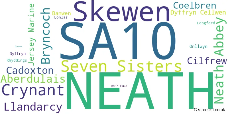
The largest settlement in the SA10 postal code is SKEWEN followed by NEATH, and SEVEN SISTERS.
The postcode area has a boundary with The Bristol Channel.
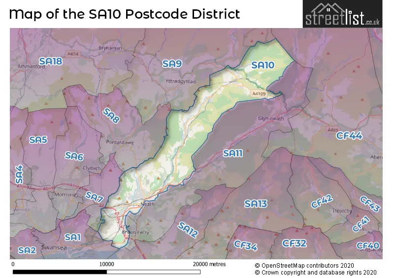
The SA10 Postcode shares a border with SA7 (BIRCHGROVE, Llansamlet, SWANSEA ENTERPRISE PARK), SA8 (PONTARDAWE, ALLTWEN, RHOS), SA9 (YSTRADGYNLAIS, Ystalyfera, LOWER CWMTWRCH) and SA11 (NEATH, Briton Ferry, GLYNNEATH).
The SA10 postcode district is primarily represented by the settlement of Neath in the county of West Glamorgan, Wales. Other significant settlements in this postcode district include Jersey Marine, Llandarcy, Lonlas, Neath Abbey, Skewen, Bryncoch, Dyffryn, Aberdulais, Cadoxton, Cilfrew, Crynant, Rhyddings, Tonna, Banwen, Coelbren, Dyffryn Cellwen, Onllwyn, and Seven Sisters. The most significant post town in this postcode district is Neath.
For the district SA10, we have data on 4 postcode sectors. Here's a breakdown: The sector SA10 6, covers Skewen and Neath and Llandarcy in West Glamorgan. The sector SA10 7, covers Neath and Bryncoch and Neath Abbey in West Glamorgan. The sector SA10 8, covers Crynant and Aberdulais and Cadoxton and Cilfrew and Neath in West Glamorgan. The sector SA10 9, covers Seven Sisters and Dyffryn Cellwen in West Glamorgan. The sector SA10 9, covers Coelbren in Powys.

Map of the SA10 Postcode District
Explore the SA10 postcode district by using our free interactive map.
When it comes to local government, postal geography often disregards political borders. However, for a breakdown in the SA10 District: the district mostly encompasses the Castell-nedd Port Talbot - Neath Port Talbot (751 postcodes), and finally, the Powys - Powys area (25 postcodes).
Recent House Sales in SA10
| Date | Price | Address |
|---|---|---|
| 05/10/2023 | £165,000 | Llwyn Y Bryn, Skewen, Neath, SA10 6DZ |
| 02/10/2023 | £120,000 | Golwg Y Bryn, Seven Sisters, Neath, SA10 9BR |
| 29/09/2023 | £300,000 | Cefn Parc, Neath, SA10 6YR |
| 27/09/2023 | £151,000 | Cardonnel Road, Neath, SA10 6DE |
| 22/09/2023 | £130,000 | Fernlea Park, Neath, SA10 7SX |
| 22/09/2023 | £239,995 | Friars Close, Neath, SA10 7JB |
| 22/09/2023 | £145,000 | Oak Hill Park, Skewen, Neath, SA10 6TB |
| 22/09/2023 | £298,000 | Leiros Parc Drive, Bryncoch, Neath, SA10 7EW |
| 18/09/2023 | £115,000 | Moorlands, Dyffryn Cellwen, Neath, SA10 9HY |
| 08/09/2023 | £115,000 | Oak Hill Park, Skewen, Neath, SA10 6TB |
Weather Forecast for SA10
Press Button to Show Forecast for Ystradgynlais
| Time Period | Icon | Description | Temperature | Rain Probability | Wind |
|---|---|---|---|---|---|
| 09:00 to 12:00 | Overcast | 10.0°C (feels like 8.0°C) | 32.00% | WNW 11 mph | |
| 12:00 to 15:00 | Light rain | 11.0°C (feels like 8.0°C) | 45.00% | NW 11 mph | |
| 15:00 to 18:00 | Partly cloudy (day) | 13.0°C (feels like 11.0°C) | 3.00% | NNW 11 mph | |
| 18:00 to 21:00 | Sunny day | 11.0°C (feels like 9.0°C) | 0.00% | NNW 9 mph | |
| 21:00 to 00:00 | Clear night | 8.0°C (feels like 6.0°C) | 0.00% | NNW 4 mph |
Press Button to Show Forecast for Ystradgynlais
| Time Period | Icon | Description | Temperature | Rain Probability | Wind |
|---|---|---|---|---|---|
| 00:00 to 03:00 | Clear night | 5.0°C (feels like 4.0°C) | 0.00% | N 2 mph | |
| 03:00 to 06:00 | Clear night | 4.0°C (feels like 2.0°C) | 0.00% | NE 2 mph | |
| 06:00 to 09:00 | Sunny day | 4.0°C (feels like 3.0°C) | 0.00% | ENE 2 mph | |
| 09:00 to 12:00 | Sunny day | 9.0°C (feels like 9.0°C) | 0.00% | SW 2 mph | |
| 12:00 to 15:00 | Cloudy | 12.0°C (feels like 11.0°C) | 4.00% | WNW 4 mph | |
| 15:00 to 18:00 | Cloudy | 12.0°C (feels like 11.0°C) | 5.00% | W 7 mph | |
| 18:00 to 21:00 | Cloudy | 12.0°C (feels like 10.0°C) | 4.00% | NW 7 mph | |
| 21:00 to 00:00 | Clear night | 9.0°C (feels like 8.0°C) | 0.00% | NNE 7 mph |
Press Button to Show Forecast for Ystradgynlais
| Time Period | Icon | Description | Temperature | Rain Probability | Wind |
|---|---|---|---|---|---|
| 00:00 to 03:00 | Clear night | 7.0°C (feels like 6.0°C) | 0.00% | ENE 4 mph | |
| 03:00 to 06:00 | Clear night | 5.0°C (feels like 4.0°C) | 0.00% | ENE 4 mph | |
| 06:00 to 09:00 | Sunny day | 6.0°C (feels like 5.0°C) | 1.00% | NE 4 mph | |
| 09:00 to 12:00 | Sunny day | 10.0°C (feels like 9.0°C) | 1.00% | ENE 4 mph | |
| 12:00 to 15:00 | Cloudy | 13.0°C (feels like 12.0°C) | 5.00% | NE 4 mph | |
| 15:00 to 18:00 | Overcast | 13.0°C (feels like 12.0°C) | 12.00% | N 7 mph | |
| 18:00 to 21:00 | Cloudy | 12.0°C (feels like 11.0°C) | 12.00% | NNE 7 mph | |
| 21:00 to 00:00 | Partly cloudy (night) | 9.0°C (feels like 8.0°C) | 4.00% | NE 4 mph |
Press Button to Show Forecast for Ystradgynlais
| Time Period | Icon | Description | Temperature | Rain Probability | Wind |
|---|---|---|---|---|---|
| 00:00 to 03:00 | Partly cloudy (night) | 8.0°C (feels like 6.0°C) | 2.00% | ENE 4 mph | |
| 03:00 to 06:00 | Cloudy | 7.0°C (feels like 5.0°C) | 4.00% | ENE 4 mph | |
| 06:00 to 09:00 | Cloudy | 7.0°C (feels like 6.0°C) | 5.00% | E 2 mph | |
| 09:00 to 12:00 | Cloudy | 9.0°C (feels like 8.0°C) | 5.00% | SE 4 mph | |
| 12:00 to 15:00 | Cloudy | 11.0°C (feels like 10.0°C) | 9.00% | SE 7 mph | |
| 15:00 to 18:00 | Cloudy | 12.0°C (feels like 10.0°C) | 16.00% | SW 9 mph | |
| 18:00 to 21:00 | Cloudy | 11.0°C (feels like 9.0°C) | 12.00% | N 9 mph | |
| 21:00 to 00:00 | Cloudy | 9.0°C (feels like 7.0°C) | 9.00% | NNE 7 mph |
Press Button to Show Forecast for Ystradgynlais
| Time Period | Icon | Description | Temperature | Rain Probability | Wind |
|---|---|---|---|---|---|
| 00:00 to 03:00 | Cloudy | 8.0°C (feels like 7.0°C) | 5.00% | ENE 7 mph | |
| 03:00 to 06:00 | Cloudy | 7.0°C (feels like 6.0°C) | 4.00% | NE 4 mph | |
| 06:00 to 09:00 | Cloudy | 8.0°C (feels like 7.0°C) | 5.00% | NE 4 mph | |
| 09:00 to 12:00 | Partly cloudy (day) | 10.0°C (feels like 9.0°C) | 3.00% | NE 7 mph | |
| 12:00 to 15:00 | Cloudy | 13.0°C (feels like 11.0°C) | 7.00% | NNE 9 mph | |
| 15:00 to 18:00 | Cloudy | 13.0°C (feels like 11.0°C) | 12.00% | NE 9 mph | |
| 18:00 to 21:00 | Partly cloudy (day) | 12.0°C (feels like 10.0°C) | 4.00% | NNE 9 mph | |
| 21:00 to 00:00 | Partly cloudy (night) | 9.0°C (feels like 8.0°C) | 2.00% | N 7 mph |
Where is the SA10 Postcode District?
The data suggests that the postcode district of SA10 is located in the town of Neath. Neath is situated in close proximity to several nearby towns, including Maesteg to the south, Treorchy to the southeast, Swansea to the southwest, Aberdare to the east, and Ammanford to the northwest. Additionally, the distance from Neath to the center of London is approximately 156.06 miles.
The district is within the post town of NEATH.
The sector has postcodes within the nation of Wales.
The SA10 Postcode District is covers the following regions.
- Bridgend and Neath Port Talbot - West Wales - Wales
- Powys - East Wales - Wales
| Postcode Sector | Delivery Office |
|---|---|
| SA10 6 | Neath Delivery Office |
| SA10 7 | Neath Delivery Office |
| SA10 8 | Neath Delivery Office |
| SA10 9 | Neath Delivery Office |
| S | A | 1 | 0 | - | X | X | X |
| S | A | 1 | 0 | Space | Numeric | Letter | Letter |
Tourist Attractions within the Postcode Area
We found 1 visitor attractions within the SA10 postcode area
| Aberdulais Falls |
|---|
| View Aberdulais Falls on Google Maps |
Current Monthly Rental Prices
| # Bedrooms | Min Price | Max Price | Avg Price |
|---|---|---|---|
| 2 | £495 | £750 | £623 |
| 3 | £800 | £875 | £850 |
| 4 | £1,850 | £1,850 | £1,850 |
Current House Prices
| # Bedrooms | Min Price | Max Price | Avg Price |
|---|---|---|---|
| £69,500 | £250,000 | £166,583 | |
| 1 | £30,000 | £84,950 | £61,650 |
| 2 | £90,000 | £285,000 | £172,725 |
| 3 | £65,000 | £449,950 | £226,834 |
| 4 | £200,000 | £825,000 | £362,227 |
| 5 | £300,000 | £750,000 | £447,990 |
| 6 | £445,000 | £500,000 | £475,000 |
Estate Agents who Operate in the SA10 District
| Logo | Name | Brand Name | Address | Contact Number | Total Properties |
|---|---|---|---|---|---|
 | Neath | Peter Alan | 41 Alfred Street, Neath, SA11 1EH | 01639 505098 | 27 |
 | Neath | Peter Morgan | 33-35 Windsor Road, Neath, SA11 1LU | 01639 505110 | 23 |
 | Neath | Clee Tompkinson & Francis | 82 Windsor Road, Neath, SA11 1NR | 01639 501180 | 20 |
 | Neath | Herbert R Thomas | 33 Alfred Street, Neath, SA11 1EH | 01639 501168 | 19 |
 | Neath | Astleys | 35 Alfred Street, Neath, SA11 1EH | 01639 501174 | 19 |
| Type of Property | 2018 Average | 2018 Sales | 2017 Average | 2017 Sales | 2016 Average | 2016 Sales | 2015 Average | 2015 Sales |
|---|---|---|---|---|---|---|---|---|
| Detached | £208,328 | 147 | £200,614 | 173 | £210,420 | 186 | £198,522 | 207 |
| Semi-Detached | £122,940 | 209 | £117,362 | 195 | £118,742 | 204 | £116,539 | 214 |
| Terraced | £100,887 | 117 | £105,809 | 148 | £100,127 | 109 | £97,940 | 116 |
| Flats | £98,250 | 12 | £95,589 | 14 | £75,476 | 19 | £73,495 | 15 |
Hotels within the Postcode Area
We found 3 hotels and guest houses within the SA10 postcode area
Holiday Inn Express Swansea East
M4, Jct 43, Llandarcy, Neath, Swansea, llandarcy, SA10 6GZ.
View details