The SA10 7 postcode sector is within the county of West Glamorgan.
Did you know? According to the 2021 Census, the SA10 7 postcode sector is home to a bustling 9,549 residents!
Given that each sector allows for 400 unique postcode combinations. Letters C, I, K, M, O and V are not allowed in the last two letters of a postcode. With 240 postcodes already in use, this leaves 160 units available.
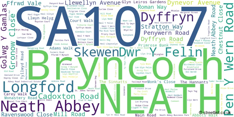
The largest settlement in the SA10 7 postal code is NEATH followed by Bryncoch, and Neath Abbey.
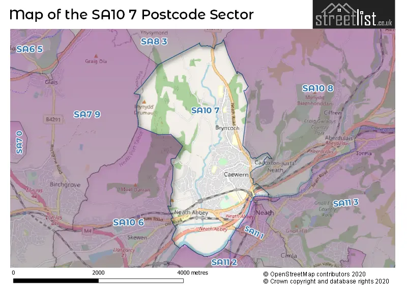
The SA10 7 Postcode shares a border with SA7 9 (Llansamlet, BIRCHGROVE, SWANSEA ENTERPRISE PARK), SA8 3 (PONTARDAWE, ALLTWEN, RHOS), SA11 1 (NEATH, CIMLA), SA11 2 (NEATH, Briton Ferry, Penrhiwtyn), SA10 6 (SKEWEN, LLANDARCY, NEATH) and SA10 8 (CRYNANT, CADOXTON, ABERDULAIS).
The sector is within the post town of NEATH.
SA10 7 is a postcode sector within the SA10 postcode district which is within the SA Swansea postcode area.
The Royal Mail delivery office for the SA10 7 postal sector is the Neath Delivery Office.
The area of the SA10 7 postcode sector is 3.58 square miles which is 9.28 square kilometres or 2,293.32 square acres.

Map of the SA10 7 Postcode Sector
Explore the SA10 7 postcode sector by using our free interactive map.
| S | A | 1 | 0 | - | 7 | X | X |
| S | A | 1 | 0 | Space | 7 | Letter | Letter |
Official List of Streets
NEATH (110 Streets)
Bryncoch (20 Streets)
Neath Abbey (20 Streets)
Skewen (2 Streets)
Unofficial Streets or Alternative Spellings
NEATH
CROMWELL ROAD GILFACH ROADBryncoch
KESTREL CLOSERhyddings
ALEXANDER ROADWeather Forecast for SA10 7
Press Button to Show Forecast for Neath Abbey
| Time Period | Icon | Description | Temperature | Rain Probability | Wind |
|---|---|---|---|---|---|
| 12:00 to 15:00 | Cloudy | 11.0°C (feels like 11.0°C) | 5.00% | NNE 2 mph | |
| 15:00 to 18:00 | Cloudy | 12.0°C (feels like 11.0°C) | 4.00% | E 7 mph | |
| 18:00 to 21:00 | Cloudy | 11.0°C (feels like 10.0°C) | 8.00% | SW 4 mph | |
| 21:00 to 00:00 | Clear night | 8.0°C (feels like 6.0°C) | 0.00% | NNW 7 mph |
Press Button to Show Forecast for Neath Abbey
| Time Period | Icon | Description | Temperature | Rain Probability | Wind |
|---|---|---|---|---|---|
| 00:00 to 03:00 | Clear night | 6.0°C (feels like 4.0°C) | 0.00% | NNW 4 mph | |
| 03:00 to 06:00 | Partly cloudy (night) | 6.0°C (feels like 4.0°C) | 5.00% | N 4 mph | |
| 06:00 to 09:00 | Cloudy | 7.0°C (feels like 6.0°C) | 9.00% | SW 2 mph | |
| 09:00 to 12:00 | Cloudy | 10.0°C (feels like 8.0°C) | 8.00% | NW 7 mph | |
| 12:00 to 15:00 | Cloudy | 12.0°C (feels like 9.0°C) | 6.00% | NW 11 mph | |
| 15:00 to 18:00 | Cloudy | 12.0°C (feels like 10.0°C) | 4.00% | NW 11 mph | |
| 18:00 to 21:00 | Cloudy | 10.0°C (feels like 8.0°C) | 4.00% | NNW 9 mph | |
| 21:00 to 00:00 | Cloudy | 8.0°C (feels like 6.0°C) | 4.00% | NNW 7 mph |
Press Button to Show Forecast for Neath Abbey
| Time Period | Icon | Description | Temperature | Rain Probability | Wind |
|---|---|---|---|---|---|
| 00:00 to 03:00 | Cloudy | 7.0°C (feels like 5.0°C) | 4.00% | NNE 4 mph | |
| 03:00 to 06:00 | Cloudy | 6.0°C (feels like 5.0°C) | 4.00% | NE 4 mph | |
| 06:00 to 09:00 | Cloudy | 7.0°C (feels like 4.0°C) | 6.00% | ENE 7 mph | |
| 09:00 to 12:00 | Cloudy | 9.0°C (feels like 6.0°C) | 9.00% | E 11 mph | |
| 12:00 to 15:00 | Cloudy | 10.0°C (feels like 8.0°C) | 9.00% | ESE 9 mph | |
| 15:00 to 18:00 | Cloudy | 11.0°C (feels like 9.0°C) | 11.00% | ESE 9 mph | |
| 18:00 to 21:00 | Cloudy | 11.0°C (feels like 9.0°C) | 13.00% | E 7 mph | |
| 21:00 to 00:00 | Cloudy | 9.0°C (feels like 7.0°C) | 11.00% | ENE 9 mph |
Press Button to Show Forecast for Neath Abbey
| Time Period | Icon | Description | Temperature | Rain Probability | Wind |
|---|---|---|---|---|---|
| 00:00 to 03:00 | Cloudy | 8.0°C (feels like 5.0°C) | 13.00% | ENE 9 mph | |
| 03:00 to 06:00 | Cloudy | 7.0°C (feels like 4.0°C) | 10.00% | ENE 11 mph | |
| 06:00 to 09:00 | Cloudy | 7.0°C (feels like 4.0°C) | 8.00% | ENE 11 mph | |
| 09:00 to 12:00 | Cloudy | 9.0°C (feels like 6.0°C) | 7.00% | ENE 13 mph | |
| 12:00 to 15:00 | Overcast | 11.0°C (feels like 8.0°C) | 14.00% | ENE 11 mph | |
| 15:00 to 18:00 | Overcast | 11.0°C (feels like 9.0°C) | 17.00% | ENE 11 mph | |
| 18:00 to 21:00 | Cloudy | 11.0°C (feels like 9.0°C) | 12.00% | NE 11 mph | |
| 21:00 to 00:00 | Overcast | 10.0°C (feels like 7.0°C) | 20.00% | NNE 11 mph |
Press Button to Show Forecast for Neath Abbey
| Time Period | Icon | Description | Temperature | Rain Probability | Wind |
|---|---|---|---|---|---|
| 00:00 to 03:00 | Overcast | 9.0°C (feels like 6.0°C) | 17.00% | NNE 11 mph | |
| 03:00 to 06:00 | Light rain | 8.0°C (feels like 5.0°C) | 47.00% | N 11 mph | |
| 06:00 to 09:00 | Light rain | 8.0°C (feels like 5.0°C) | 47.00% | N 11 mph | |
| 09:00 to 12:00 | Light rain shower (day) | 9.0°C (feels like 6.0°C) | 40.00% | N 13 mph | |
| 12:00 to 15:00 | Cloudy | 11.0°C (feels like 8.0°C) | 19.00% | NNW 16 mph | |
| 15:00 to 18:00 | Cloudy | 12.0°C (feels like 9.0°C) | 15.00% | NW 13 mph | |
| 18:00 to 21:00 | Sunny day | 11.0°C (feels like 9.0°C) | 8.00% | NW 13 mph | |
| 21:00 to 00:00 | Clear night | 9.0°C (feels like 7.0°C) | 5.00% | NW 9 mph |
House Prices in the SA10 7 Postcode Sector
| Type of Property | 2018 Average | 2018 Sales | 2017 Average | 2017 Sales | 2016 Average | 2016 Sales | 2015 Average | 2015 Sales |
|---|---|---|---|---|---|---|---|---|
| Detached | £198,878 | 54 | £203,286 | 64 | £198,830 | 51 | £197,167 | 61 |
| Semi-Detached | £136,255 | 46 | £125,660 | 50 | £128,352 | 50 | £122,638 | 39 |
| Terraced | £112,869 | 29 | £112,464 | 30 | £93,331 | 21 | £108,159 | 27 |
| Flats | £68,750 | 2 | £69,550 | 5 | £56,000 | 2 | £54,122 | 4 |
Important Postcodes SA10 7 in the Postcode Sector
SA10 7AE is the postcode for BRONLEIGH, 6, Cadoxton Road
SA10 7BR is the postcode for Neath Sports Centre, Neath Abbey Road
SA10 7DR is the postcode for Vocational Skills Centre, Neath Abbey Business Park
SA10 7LB is the postcode for Neath Abbey Early Years Unit, Heol Penlan
SA10 7LD is the postcode for Dwr y Felin Lower Comprehensive School, Heol Penlan
SA10 7ND is the postcode for Mynachlog Nedd Junior School, St. Johns Terrace, Neath Abbey, and Mynachlog Nedd Junior School, St. Johns Terrace
SA10 7NG is the postcode for Neath Abbey Infant School, New Road
SA10 7PE is the postcode for Blaenhonddan Primary School, Main Road, Bryncoch, and Blaenhonddan Primary School, Main Road
SA10 7RE is the postcode for Dwr Y Felin Upper Comprehensive School, Dwr Y Felin Road, A BLOCK NEW BLOCK, Dwr Y Felin Upper Comprehensive, Dwr Y Felin Road, QUAD BLOCK, Dwr Y Felin Upper Comprehensive, Dwr Y Felin Road, DWR Y FELIN UPPER COMPREHENSIVE SCHOOL, DWR Y FELIN ROAD, CAEWERN, TECHNOLOGY BLOCK, Dwr Y Felin Upper Comprehensive, Dwr Y Felin Road, HOME ECONOMICS BLOCK, Dwr Y Felin Upper Comprehensive, Dwr Y Felin Road, and C BLOCK TEACHING & DINING BLOCK, Dwr Y Felin Upper Comprehensive, Dwr Y Felin Road
SA10 7RF is the postcode for Brickwork Block, Neath Port Talbot College, Dwr Y Felin Road, A AND B BLOCK, Neath Port Talbot College, Dwr y Felin Road, Neath Port Talbot College, Dwr y Felin Road, C BLOCK, Neath Port Talbot College, Dwr y Felin Road, NEATH COLLEGE THEATRE, Neath Port Talbot College, Dwr y Felin Road, G BLOCK, Neath Port Talbot College, Dwr y Felin Road, New Brickwork Block, Neath Port Talbot College, Dwr Y Felin Road, ELC, Neath Port Talbot College, Dwr y Felin Road, C BLOCK MEDIA NEATH PORT TALBOT COLLEGE, Neath Port Talbot College, Dwr y Felin Road, and C BLOCK (Catering & Bakery), Neath Port Talbot College, Dwr y Felin Road
SA10 7RH is the postcode for Caewern Home For The Aged, Upper House, Dwr Y Felin Road
SA10 7RW is the postcode for Waunceirch Primary School, Caewern, and Waunceirch Primary School, Dwr Y Felin Road
SA10 7TY is the postcode for Ysgol Hendre Residential School, Main Road, Ysgol Maes y Coed, Main Road, Bryncoch, Ysgol Maes Y Coed, Heol Hendre, Ysgol Maes y Coed, Main Road, Ysgol Hendrefelin, Heol Hendre, and Ysgol Hendre Residential School, Main Road, Bryncoch
SA10 7UB is the postcode for Gorffwysfa Home for the Aged, 1a Llys Gwynfryn
SA10 7UG is the postcode for Bryncoch Church In Wales Primary School, Furzeland Drive, and Bryncoch Church in Wales School, Furzeland Drive
| The SA10 7 Sector is within these Local Authorities |
|
|---|---|
| The SA10 7 Sector is within these Counties |
|
| The SA10 7 Sector is within these Water Company Areas |
|