The SA11 1 postcode sector is within the county of West Glamorgan.
Did you know? According to the 2021 Census, the SA11 1 postcode sector is home to a bustling 6,126 residents!
Given that each sector allows for 400 unique postcode combinations. Letters C, I, K, M, O and V are not allowed in the last two letters of a postcode. With 215 postcodes already in use, this leaves 185 units available.
The largest settlements in the SA11 1 postal code are NEATH and CIMLA.
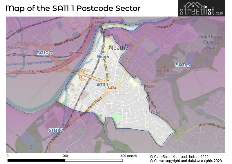
The SA11 1 Postcode shares a border with SA11 2 (NEATH, Briton Ferry, Penrhiwtyn), SA11 3 (NEATH, TONNA, CIMLA), SA10 7 (NEATH, Bryncoch, Neath Abbey) and SA10 8 (CRYNANT, CADOXTON, ABERDULAIS).
The sector is within the post town of NEATH.
SA11 1 is a postcode sector within the SA11 postcode district which is within the SA Swansea postcode area.
The Royal Mail delivery office for the SA11 1 postal sector is the Neath Delivery Office.
The area of the SA11 1 postcode sector is 0.56 square miles which is 1.44 square kilometres or 355.54 square acres.

Map of the SA11 1 Postcode Sector
Explore the SA11 1 postcode sector by using our free interactive map.
| S | A | 1 | 1 | - | 1 | X | X |
| S | A | 1 | 1 | Space | 1 | Letter | Letter |
Official List of Streets
NEATH (108 Streets)
Unofficial Streets or Alternative Spellings
Cimla
AFAN VALLEY ROADNEATH
BEACONS VIEW BEECHWOOD AVENUE BWLCH ROAD CHURCH PLACE CIMLA COMMON CIMLA ROAD EAGLESBUSH VALLEY FAIRFIELD WAY PRINCE OF WALES DRIVE VALLEY VIEW WATER STREET WIND STREET ALFORD ROAD BRICKYARD COTTAGES BRYN AWEL CAE RHYS DDU CATTLE STREET CRIBBS ROW CRYDDAN ROAD D C GRIFFITHS WAY DAN Y CRAIG ROAD DAN-Y-GRAIG ROAD EASTLAND PLACE EDWARD STREET HEOL CEI KINGDON-OWEN ROAD MAES Y FFYNNON CLOSE MAES YR HAF ROAD MAES-YR-H�F ROAD MILLAND ROAD NELSON MANDELA WAY PEN Y BRYN SAINT DAVIDS STREET STRYD DEWI SANT SUMMERFIELD PLACE TY-SEGUR ZOAR ROADBriton Ferry
OLD ROADWeather Forecast for SA11 1
Press Button to Show Forecast for Neath
| Time Period | Icon | Description | Temperature | Rain Probability | Wind |
|---|---|---|---|---|---|
| 15:00 to 18:00 | Cloudy | 12.0°C (feels like 10.0°C) | 4.00% | NW 11 mph | |
| 18:00 to 21:00 | Cloudy | 11.0°C (feels like 8.0°C) | 4.00% | NNW 11 mph | |
| 21:00 to 00:00 | Cloudy | 8.0°C (feels like 6.0°C) | 4.00% | NNW 7 mph |
Press Button to Show Forecast for Neath
| Time Period | Icon | Description | Temperature | Rain Probability | Wind |
|---|---|---|---|---|---|
| 00:00 to 03:00 | Cloudy | 7.0°C (feels like 6.0°C) | 4.00% | NNE 4 mph | |
| 03:00 to 06:00 | Cloudy | 6.0°C (feels like 5.0°C) | 4.00% | NE 4 mph | |
| 06:00 to 09:00 | Cloudy | 7.0°C (feels like 4.0°C) | 6.00% | ENE 7 mph | |
| 09:00 to 12:00 | Cloudy | 9.0°C (feels like 6.0°C) | 11.00% | E 11 mph | |
| 12:00 to 15:00 | Cloudy | 10.0°C (feels like 8.0°C) | 9.00% | ESE 9 mph | |
| 15:00 to 18:00 | Cloudy | 11.0°C (feels like 9.0°C) | 12.00% | ESE 9 mph | |
| 18:00 to 21:00 | Cloudy | 11.0°C (feels like 9.0°C) | 13.00% | E 7 mph | |
| 21:00 to 00:00 | Cloudy | 9.0°C (feels like 7.0°C) | 11.00% | ENE 9 mph |
Press Button to Show Forecast for Neath
| Time Period | Icon | Description | Temperature | Rain Probability | Wind |
|---|---|---|---|---|---|
| 00:00 to 03:00 | Cloudy | 8.0°C (feels like 5.0°C) | 14.00% | ENE 9 mph | |
| 03:00 to 06:00 | Cloudy | 7.0°C (feels like 4.0°C) | 10.00% | ENE 11 mph | |
| 06:00 to 09:00 | Cloudy | 7.0°C (feels like 4.0°C) | 7.00% | ENE 11 mph | |
| 09:00 to 12:00 | Cloudy | 9.0°C (feels like 6.0°C) | 7.00% | ENE 13 mph | |
| 12:00 to 15:00 | Overcast | 11.0°C (feels like 8.0°C) | 14.00% | ENE 11 mph | |
| 15:00 to 18:00 | Overcast | 11.0°C (feels like 9.0°C) | 17.00% | ENE 11 mph | |
| 18:00 to 21:00 | Cloudy | 11.0°C (feels like 9.0°C) | 12.00% | NE 11 mph | |
| 21:00 to 00:00 | Overcast | 10.0°C (feels like 7.0°C) | 20.00% | NNE 11 mph |
Press Button to Show Forecast for Neath
| Time Period | Icon | Description | Temperature | Rain Probability | Wind |
|---|---|---|---|---|---|
| 00:00 to 03:00 | Overcast | 9.0°C (feels like 6.0°C) | 17.00% | NNE 11 mph | |
| 03:00 to 06:00 | Light rain | 8.0°C (feels like 5.0°C) | 49.00% | N 11 mph | |
| 06:00 to 09:00 | Light rain | 8.0°C (feels like 5.0°C) | 49.00% | N 11 mph | |
| 09:00 to 12:00 | Light rain shower (day) | 9.0°C (feels like 6.0°C) | 40.00% | N 13 mph | |
| 12:00 to 15:00 | Cloudy | 11.0°C (feels like 8.0°C) | 19.00% | NNW 16 mph | |
| 15:00 to 18:00 | Cloudy | 12.0°C (feels like 9.0°C) | 15.00% | NNW 13 mph | |
| 18:00 to 21:00 | Sunny day | 11.0°C (feels like 9.0°C) | 8.00% | NW 11 mph | |
| 21:00 to 00:00 | Clear night | 9.0°C (feels like 7.0°C) | 5.00% | NW 9 mph |
House Prices in the SA11 1 Postcode Sector
| Type of Property | 2018 Average | 2018 Sales | 2017 Average | 2017 Sales | 2016 Average | 2016 Sales | 2015 Average | 2015 Sales |
|---|---|---|---|---|---|---|---|---|
| Detached | £110,000 | 5 | £211,600 | 5 | £139,500 | 2 | £149,000 | 2 |
| Semi-Detached | £132,644 | 17 | £104,185 | 13 | £110,733 | 15 | £96,354 | 12 |
| Terraced | £80,213 | 75 | £73,155 | 76 | £80,249 | 74 | £71,928 | 55 |
| Flats | £79,790 | 5 | £71,908 | 6 | £83,000 | 4 | £73,167 | 6 |
Important Postcodes SA11 1 in the Postcode Sector
SA11 1AQ is the postcode for Gnoll Primary School, Wellfield Avenue
SA11 1DJ is the postcode for THE LAURELS, 87, Lewis Road
SA11 1DU is the postcode for Gwyn Hall Theatre, Orchard Street
SA11 1HL is the postcode for 119 London Road
SA11 1LT is the postcode for Royal Mail, Neath Delivery Office, 20 Windsor Road
SA11 1LY is the postcode for Jobcentre Plus, 1 Windsor Road, and 1 Windsor Road
SA11 1RF is the postcode for Neath Magistrates Court, 11 Fairfield Way, and Clerk to the Justices, Neath Magistrates Court, 11 Fairfield Way
SA11 1RS is the postcode for Angel Inn, Angel Street
SA11 1UL is the postcode for Hillside Secure Centre, Burnside
SA11 1YB is the postcode for Beaufort House, Groves Road
| The SA11 1 Sector is within these Local Authorities |
|
|---|---|
| The SA11 1 Sector is within these Counties |
|
| The SA11 1 Sector is within these Water Company Areas |
|