The SA12 7 postcode sector is within the county of West Glamorgan.
Did you know? According to the 2021 Census, the SA12 7 postcode sector is home to a bustling 8,384 residents!
Given that each sector allows for 400 unique postcode combinations. Letters C, I, K, M, O and V are not allowed in the last two letters of a postcode. With 193 postcodes already in use, this leaves 207 units available.
The largest settlement in the SA12 7 postal code is PORT TALBOT followed by SANDFIELDS, and ABERAVON.
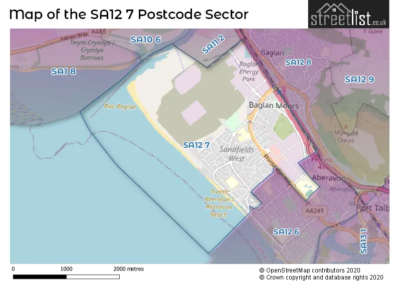
The SA12 7 Postcode shares a border with SA11 2 (NEATH, Briton Ferry, Penrhiwtyn), SA12 6 (PORT TALBOT, SANDFIELDS, ABERAVON) and SA12 8 (BAGLAN, PORT TALBOT).
The sector is within the post town of PORT TALBOT.
SA12 7 is a postcode sector within the SA12 postcode district which is within the SA Swansea postcode area.
The Royal Mail delivery office for the SA12 7 postal sector is the Port Talbot Delivery Office.
The area of the SA12 7 postcode sector is 2.43 square miles which is 6.29 square kilometres or 1,553.99 square acres.

Map of the SA12 7 Postcode Sector
Explore the SA12 7 postcode sector by using our free interactive map.
| S | A | 1 | 2 | - | 7 | X | X |
| S | A | 1 | 2 | Space | 7 | Letter | Letter |
Official List of Streets
PORT TALBOT (97 Streets)
Baglan Industrial Park (3 Streets)
Baglan (5 Streets)
Unofficial Streets or Alternative Spellings
PORT TALBOT
ABBOTTSMOOR AFAN WAY DALTON ROAD FARM DRIVE BRYN GARDENS CRIMSON COURT ENDEAVOUR CLOSE FFORDD AFAN WAY GREIG COURT GRIEG COURT HELIOS DRIVE HEOL DETANI HEOL TIR MORFA HEOL Y PENTREF / VILLAGE ROAD JASMIN CLOSE LONG VIEW ROAD MAES Y DRINDOD MARDON PARK MOZART COUNT MOZART MEWS RHODFA ACACIA ROAD NO 1 ROAD NO 2 ROAD NO 3 SANDPIPER COURT SEAWAY DRIVE SIRIUS DRIVE SOUTH CROSS WAY SOUTHDOWN COURT ST. ASAPH COURT ST. HELLIER DRIVE STREET NO 17 STREET NO 21 THE PRINCESS MARGARET WAY TIMBER PLACE TURNSTONE COURT VILLAGE ROADWeather Forecast for SA12 7
Press Button to Show Forecast for Briton Ferry
| Time Period | Icon | Description | Temperature | Rain Probability | Wind |
|---|---|---|---|---|---|
| 12:00 to 15:00 | Cloudy | 11.0°C (feels like 9.0°C) | 7.00% | NW 11 mph | |
| 15:00 to 18:00 | Cloudy | 11.0°C (feels like 9.0°C) | 7.00% | NW 11 mph | |
| 18:00 to 21:00 | Cloudy | 11.0°C (feels like 8.0°C) | 4.00% | NNW 11 mph | |
| 21:00 to 00:00 | Cloudy | 8.0°C (feels like 6.0°C) | 4.00% | NNW 7 mph |
Press Button to Show Forecast for Briton Ferry
| Time Period | Icon | Description | Temperature | Rain Probability | Wind |
|---|---|---|---|---|---|
| 00:00 to 03:00 | Cloudy | 7.0°C (feels like 6.0°C) | 4.00% | NNE 4 mph | |
| 03:00 to 06:00 | Cloudy | 7.0°C (feels like 5.0°C) | 4.00% | NE 4 mph | |
| 06:00 to 09:00 | Cloudy | 7.0°C (feels like 5.0°C) | 7.00% | ENE 7 mph | |
| 09:00 to 12:00 | Cloudy | 9.0°C (feels like 6.0°C) | 8.00% | E 11 mph | |
| 12:00 to 15:00 | Cloudy | 10.0°C (feels like 8.0°C) | 9.00% | ESE 9 mph | |
| 15:00 to 18:00 | Cloudy | 11.0°C (feels like 9.0°C) | 11.00% | ESE 9 mph | |
| 18:00 to 21:00 | Cloudy | 11.0°C (feels like 9.0°C) | 13.00% | E 7 mph | |
| 21:00 to 00:00 | Cloudy | 9.0°C (feels like 7.0°C) | 11.00% | ENE 9 mph |
Press Button to Show Forecast for Briton Ferry
| Time Period | Icon | Description | Temperature | Rain Probability | Wind |
|---|---|---|---|---|---|
| 00:00 to 03:00 | Cloudy | 8.0°C (feels like 5.0°C) | 14.00% | ENE 9 mph | |
| 03:00 to 06:00 | Cloudy | 7.0°C (feels like 4.0°C) | 10.00% | ENE 11 mph | |
| 06:00 to 09:00 | Cloudy | 7.0°C (feels like 4.0°C) | 7.00% | ENE 11 mph | |
| 09:00 to 12:00 | Cloudy | 9.0°C (feels like 6.0°C) | 7.00% | ENE 13 mph | |
| 12:00 to 15:00 | Overcast | 11.0°C (feels like 8.0°C) | 14.00% | ENE 11 mph | |
| 15:00 to 18:00 | Overcast | 11.0°C (feels like 9.0°C) | 17.00% | ENE 11 mph | |
| 18:00 to 21:00 | Cloudy | 11.0°C (feels like 9.0°C) | 12.00% | NE 11 mph | |
| 21:00 to 00:00 | Overcast | 10.0°C (feels like 7.0°C) | 20.00% | NNE 11 mph |
Press Button to Show Forecast for Briton Ferry
| Time Period | Icon | Description | Temperature | Rain Probability | Wind |
|---|---|---|---|---|---|
| 00:00 to 03:00 | Overcast | 9.0°C (feels like 6.0°C) | 17.00% | NNE 11 mph | |
| 03:00 to 06:00 | Light rain | 8.0°C (feels like 5.0°C) | 49.00% | N 11 mph | |
| 06:00 to 09:00 | Light rain | 8.0°C (feels like 5.0°C) | 47.00% | N 11 mph | |
| 09:00 to 12:00 | Light rain shower (day) | 9.0°C (feels like 6.0°C) | 40.00% | N 13 mph | |
| 12:00 to 15:00 | Cloudy | 11.0°C (feels like 8.0°C) | 19.00% | NNW 16 mph | |
| 15:00 to 18:00 | Cloudy | 12.0°C (feels like 9.0°C) | 15.00% | NW 13 mph | |
| 18:00 to 21:00 | Sunny day | 11.0°C (feels like 9.0°C) | 8.00% | NW 13 mph | |
| 21:00 to 00:00 | Clear night | 9.0°C (feels like 7.0°C) | 5.00% | NW 9 mph |
House Prices in the SA12 7 Postcode Sector
| Type of Property | 2018 Average | 2018 Sales | 2017 Average | 2017 Sales | 2016 Average | 2016 Sales | 2015 Average | 2015 Sales |
|---|---|---|---|---|---|---|---|---|
| Detached | £168,333 | 6 | £146,200 | 5 | £175,475 | 2 | £162,583 | 3 |
| Semi-Detached | £109,953 | 48 | £99,378 | 54 | £105,048 | 63 | £91,978 | 50 |
| Terraced | £100,795 | 32 | £94,985 | 20 | £97,648 | 30 | £79,929 | 30 |
| Flats | £70,000 | 2 | £0 | 0 | £62,217 | 3 | £35,000 | 1 |
Important Postcodes SA12 7 in the Postcode Sector
SA12 7AH is the postcode for Main Building, Ysgol Gymraeg Bro Dur, Southdown View, UPPER BLOCK, Sandfields Comprehensive School, Southdown View, Traethmelyn Primary School, Southdown View, and LOWER BLOCK, Sandfields Comprehensive School, Southdown View
SA12 7AX is the postcode for Baglan Innovation Centre, Baglan Energy Park, Central Avenue, Technium Sustainable Technologies, Baglan Energy Park, Central Avenue, Baglan, Technium Centre, Central Avenue, and Technium Sustainable Technologies, Baglan Energy Park, Central Avenue
SA12 7BJ is the postcode for NHS TRUST, Primary Care Resource Centre, Moor Road
SA12 7BL is the postcode for Ysgol Bae Baglan, Seaway Parade
SA12 7BN is the postcode for Main Building, Ysgol Bae Baglan, Seaway Parade
SA12 7BR is the postcode for One Talbot Gateway, Seaway Drive, Seaway Parade Industrial Estate, and One Talbot Gateway, Seaway Drive, Seaway Parade Industrial Estate, Baglan
SA12 7BX is the postcode for Neath Port Talbot Hospital, Baglan Way, CHILD DEVELOPMENT UNIT, Neath Port Talbot Hospital, Baglan Way, PRIMARY CARE RESOURCE CENTRE MOOR ROAD, Neath Port Talbot Hospital, Baglan Way, and BLOCK A RESIDENCES, Neath Port Talbot Hospital, Baglan Way
SA12 7HL is the postcode for St. Therese's Catholic Primary School, Southdown Road, St. Therese's Catholic Primary School, Southdown Road, Sandfields Estate, and St Therese's Catholic Primary School, Southdown Road
SA12 7HR is the postcode for Fairways Refuge Centre, 137 Fairway
SA12 7NN is the postcode for Y G G Rhosafan, Marine Drive, NPTCBC SKILLS AND TRAINING, TIR MORFA PRIMARY SCHOOL, MARINE DRIVE, and Tirmorfa Primary School, Marine Drive
SA12 7PH is the postcode for Trem-y-Mor, Scarlet Avenue
| The SA12 7 Sector is within these Local Authorities |
|
|---|---|
| The SA12 7 Sector is within these Counties |
|
| The SA12 7 Sector is within these Water Company Areas |
|