The SA13 postcode district is a postal district located in the SA Swansea postcode area with a population of 19,162 residents according to the 2021 England and Wales Census.
The area of the SA13 postcode district is 44.95 square miles which is 116.41 square kilometres or 28,765.06 acres.
Currently, the SA13 district has about 574 postcode units spread across 3 geographic postcode sectors.
Given that each sector allows for 400 unique postcode combinations, the district has a capacity of 1,200 postcodes. With 574 postcodes already in use, this leaves 626 units available.
The largest settlement in the SA13 postal code is PORT TALBOT followed by MARGAM, and TAIBACH.
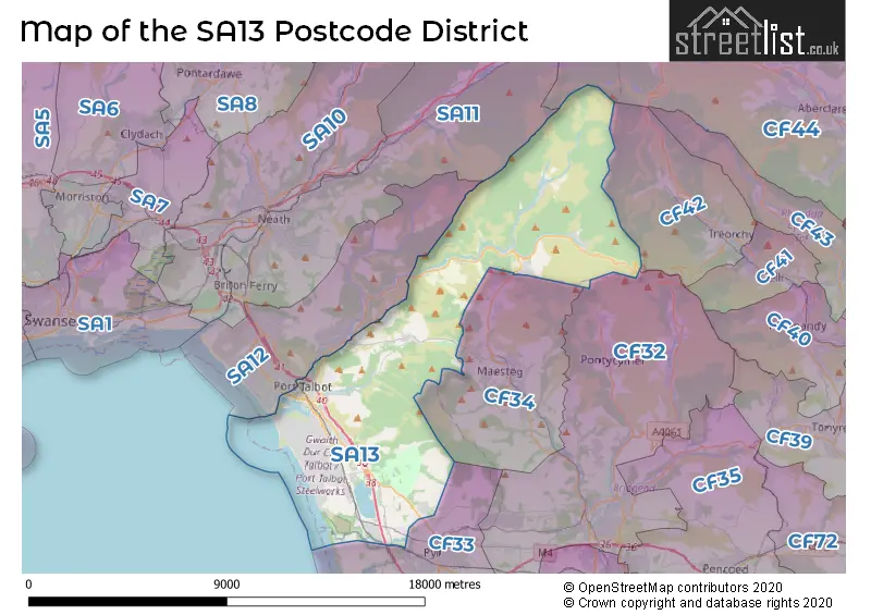
The postcode area has a boundary with The Bristol Channel.
The SA13 Postcode shares a border with CF44 (ABERDARE, HIRWAUN, Aberaman), SA11 (NEATH, Briton Ferry, GLYNNEATH), CF34 (MAESTEG, CAERAU, GARTH), CF32 (TONDU, OGMORE VALE, SARN), CF33 (NORTH CORNELLY, KENFIG HILL, PYLE) and SA12 (PORT TALBOT, BAGLAN, Cwmavon).
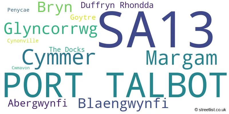
In the SA13 postcode district, the primary settlement is Port Talbot, which has the highest count of 188. Other significant settlements in the district include Bryn, Cwmavon, Goytre, Margam, Penycae, Abergwynfi, Blaengwynfi, Cymmer, Cynonville, Duffryn Rhondda, and Glyncorrwg. The post town for this district is Port Talbot, located in the county of West Glamorgan in Wales.
For the district SA13, we have data on 4 postcode sectors. Here's a breakdown: The sector SA13 1, covers Port Talbot in West Glamorgan. The sector SA13 2, covers Port Talbot and Margam and Bryn in West Glamorgan. The sector SA13 3, covers Cymmer and Glyncorrwg and Blaengwynfi in West Glamorgan. The sector SA13 9 is non-geographic. It's often designated for PO Boxes, large organisations, or special services.

Map of the SA13 Postcode District
Explore the SA13 postcode district by using our free interactive map.
When it comes to local government, postal geography often disregards political borders. However, for a breakdown in the SA13 District: the district mostly encompasses the Castell-nedd Port Talbot - Neath Port Talbot area with a total of 570 postcodes.
Recent House Sales in SA13
| Date | Price | Address |
|---|---|---|
| 20/10/2023 | £115,000 | Island Mews, Port Talbot, SA13 1XW |
| 29/09/2023 | £465,000 | Ffordd Derwen, Margam, Port Talbot, SA13 2TX |
| 28/09/2023 | £310,000 | Stallcourt Close, Port Talbot, SA13 2BG |
| 25/09/2023 | £84,000 | Brook Street, Port Talbot, SA13 1TG |
| 07/09/2023 | £135,000 | Ynys Street, Port Talbot, SA13 1YW |
| 06/09/2023 | £150,000 | Conduit Place, Port Talbot, SA13 2TT |
| 01/09/2023 | £133,000 | Incline Row, Port Talbot, SA13 1TT |
| 01/09/2023 | £129,950 | Brook Street, Port Talbot, SA13 1TG |
| 25/08/2023 | £185,000 | Hafod Street, Port Talbot, SA13 1AE |
| 24/08/2023 | £180,000 | Beechwood Road, Port Talbot, SA13 2AF |
Weather Forecast for SA13
Press Button to Show Forecast for Afan Forest
| Time Period | Icon | Description | Temperature | Rain Probability | Wind |
|---|---|---|---|---|---|
| 21:00 to 00:00 | Cloudy | 5.0°C (feels like 4.0°C) | 4.00% | N 4 mph |
Press Button to Show Forecast for Afan Forest
| Time Period | Icon | Description | Temperature | Rain Probability | Wind |
|---|---|---|---|---|---|
| 00:00 to 03:00 | Cloudy | 5.0°C (feels like 3.0°C) | 4.00% | NE 4 mph | |
| 03:00 to 06:00 | Cloudy | 4.0°C (feels like 2.0°C) | 4.00% | ENE 4 mph | |
| 06:00 to 09:00 | Cloudy | 4.0°C (feels like 2.0°C) | 7.00% | ENE 7 mph | |
| 09:00 to 12:00 | Cloudy | 7.0°C (feels like 4.0°C) | 8.00% | E 9 mph | |
| 12:00 to 15:00 | Overcast | 8.0°C (feels like 6.0°C) | 13.00% | ESE 7 mph | |
| 15:00 to 18:00 | Overcast | 9.0°C (feels like 7.0°C) | 14.00% | E 7 mph | |
| 18:00 to 21:00 | Cloudy | 8.0°C (feels like 7.0°C) | 13.00% | ENE 7 mph | |
| 21:00 to 00:00 | Cloudy | 6.0°C (feels like 4.0°C) | 12.00% | NE 7 mph |
Press Button to Show Forecast for Afan Forest
| Time Period | Icon | Description | Temperature | Rain Probability | Wind |
|---|---|---|---|---|---|
| 00:00 to 03:00 | Cloudy | 5.0°C (feels like 2.0°C) | 12.00% | ENE 7 mph | |
| 03:00 to 06:00 | Cloudy | 4.0°C (feels like 1.0°C) | 12.00% | ENE 7 mph | |
| 06:00 to 09:00 | Cloudy | 4.0°C (feels like 1.0°C) | 10.00% | ENE 7 mph | |
| 09:00 to 12:00 | Cloudy | 7.0°C (feels like 4.0°C) | 9.00% | ENE 9 mph | |
| 12:00 to 15:00 | Cloudy | 9.0°C (feels like 7.0°C) | 13.00% | ENE 9 mph | |
| 15:00 to 18:00 | Overcast | 9.0°C (feels like 7.0°C) | 18.00% | ENE 9 mph | |
| 18:00 to 21:00 | Cloudy | 9.0°C (feels like 6.0°C) | 14.00% | NE 9 mph | |
| 21:00 to 00:00 | Cloudy | 7.0°C (feels like 4.0°C) | 18.00% | NNE 9 mph |
Press Button to Show Forecast for Afan Forest
| Time Period | Icon | Description | Temperature | Rain Probability | Wind |
|---|---|---|---|---|---|
| 00:00 to 03:00 | Cloudy | 6.0°C (feels like 3.0°C) | 16.00% | NNE 11 mph | |
| 03:00 to 06:00 | Light rain | 5.0°C (feels like 2.0°C) | 50.00% | NNE 11 mph | |
| 06:00 to 09:00 | Light rain | 5.0°C (feels like 2.0°C) | 49.00% | NNE 9 mph | |
| 09:00 to 12:00 | Light rain | 6.0°C (feels like 3.0°C) | 50.00% | NNE 11 mph | |
| 12:00 to 15:00 | Light rain | 9.0°C (feels like 6.0°C) | 46.00% | NNW 13 mph | |
| 15:00 to 18:00 | Cloudy | 10.0°C (feels like 8.0°C) | 34.00% | NW 11 mph | |
| 18:00 to 21:00 | Light rain shower (day) | 9.0°C (feels like 6.0°C) | 30.00% | NNW 9 mph | |
| 21:00 to 00:00 | Clear night | 5.0°C (feels like 3.0°C) | 4.00% | NW 4 mph |
Where is the SA13 Postcode District?
The postcode district SA13 is located in the town of Port Talbot. It is situated in close proximity to several nearby towns: Maesteg in the South East at a distance of 1.5 miles, Neath in the North West at a distance of 6.5 miles, Treorchy in the East at a distance of 8 miles, Porthcawl in the South at a distance of 9 miles, and Swansea in the West at a distance of 10.9 miles. Additionally, the centre of London is approximately 153.5 miles away from this postcode district.
The district is within the post town of PORT TALBOT.
The sector has postcodes within the nation of Wales.
The SA13 Postcode District is covers the following regions.
- Bridgend and Neath Port Talbot - West Wales - Wales
- Swansea - West Wales - Wales
| Postcode Sector | Delivery Office |
|---|---|
| SA13 1 | Port Talbot Delivery Office |
| SA13 2 | Port Talbot Delivery Office |
| SA13 3 | Port Talbot Delivery Office |
| S | A | 1 | 3 | - | X | X | X |
| S | A | 1 | 3 | Space | Numeric | Letter | Letter |
Tourist Attractions within the Postcode Area
We found 3 visitor attractions within the SA13 postcode area
| Afan Forest Park |
|---|
| View Afan Forest Park on Google Maps |
| Margam Country Park |
| View Margam Country Park on Google Maps |
| Margam Stones Museum |
| View Margam Stones Museum on Google Maps |
Current Monthly Rental Prices
| # Bedrooms | Min Price | Max Price | Avg Price |
|---|---|---|---|
| 1 | £550 | £550 | £550 |
| 2 | £700 | £700 | £700 |
| 3 | £750 | £825 | £775 |
Current House Prices
| # Bedrooms | Min Price | Max Price | Avg Price |
|---|---|---|---|
| £75,000 | £110,000 | £86,667 | |
| 1 | £57,950 | £57,950 | £57,950 |
| 2 | £57,000 | £249,950 | £121,493 |
| 3 | £79,995 | £550,000 | £169,910 |
| 4 | £135,000 | £1,800,000 | £475,416 |
| 5 | £575,000 | £575,000 | £575,000 |
| 6 | £649,500 | £649,500 | £649,500 |
Estate Agents who Operate in the SA13 District
| Logo | Name | Brand Name | Address | Contact Number | Total Properties |
|---|---|---|---|---|---|
 | Port Talbot | Payton Jewell Caines | 53 Station Road Port Talbot SA13 1NW | 01639 505687 | 17 |
 | Wales | eXp UK | 1 Northumberland Avenue, Trafalgar Square, London, WC2N 5BW | 03304 609968 | 10 |
 | Neath | Peter Morgan | 33-35 Windsor Road, Neath, SA11 1LU | 01639 505110 | 9 |
 | Port Talbot | Clee Tompkinson & Francis | 40a Station Road, Port Talbot, SA13 1JS | 01639 505116 | 6 |
 | Neath | Peter Alan | 41 Alfred Street, Neath, SA11 1EH | 01639 505098 | 3 |
| Type of Property | 2018 Average | 2018 Sales | 2017 Average | 2017 Sales | 2016 Average | 2016 Sales | 2015 Average | 2015 Sales |
|---|---|---|---|---|---|---|---|---|
| Detached | £210,706 | 36 | £226,391 | 38 | £222,294 | 35 | £208,798 | 56 |
| Semi-Detached | £101,149 | 72 | £99,563 | 89 | £95,898 | 83 | £89,486 | 91 |
| Terraced | £77,664 | 150 | £79,634 | 146 | £76,911 | 114 | £74,703 | 142 |
| Flats | £50,000 | 1 | £120,000 | 2 | £40,000 | 3 | £64,568 | 4 |