The SA19 postcode district is a postal district located in the SA Swansea postcode area with a population of 9,446 residents according to the 2021 England and Wales Census.
The area of the SA19 postcode district is 202.34 square miles which is 524.05 square kilometres or 129,494.91 acres.
Currently, the SA19 district has about 828 postcode units spread across 4 geographic postcode sectors.
Given that each sector allows for 400 unique postcode combinations, the district has a capacity of 1,600 postcodes. With 828 postcodes already in use, this leaves 772 units available.
The largest settlement in the SA19 postal code is LLANDEILO followed by LLANGADOG, and FFAIRFACH.
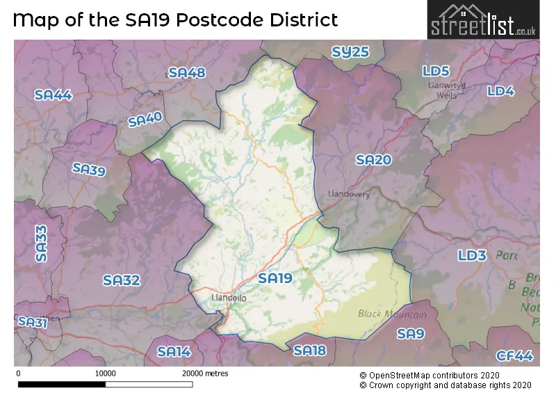
The SA19 Postcode shares a border with SY25 (TREGARON, PONTRHYDFENDIGAID, LLANDDEWI BREFI), SA20 (LLANDOVERY, RHANDIRMWYN, CYNGHORDY), SA48 (LAMPETER, CWMANN, CILIAU AERON), SA9 (YSTRADGYNLAIS, Ystalyfera, LOWER CWMTWRCH), SA18 (AMMANFORD, LLANDYBIE, GLANAMAN) and SA32 (NANTGAREDIG, LLANARTHNE, PENIEL).
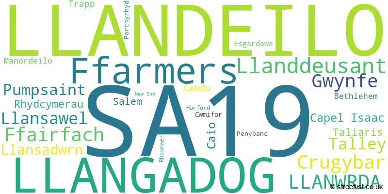
In the SA19 postcode district, the primary settlement is Llandeilo, located in the county of Dyfed in Wales. Other significant settlements in this district include Bethlehem, Ffairfach, Rhosmaen, and Trapp. Additionally, there are other settlements such as Capel Isaac, Cwmdu, Cwmifor, Esgardawe, Llansawel, Manordeilo, New Inn, Penybanc, Rhydcymerau, Salem, Taliaris, and Talley. The most significant post town in this district is Llandeilo.
For the district SA19, we have data on 5 postcode sectors. Here's a breakdown: The sector SA19 0 is non-geographic. It's often designated for PO Boxes, large organisations, or special services. The sector SA19 6, covers Llandeilo and Ffairfach in Dyfed. The sector SA19 7, covers Llansawel and Talley and Capel Isaac in Dyfed. The sector SA19 8, covers Ffarmers and Llanwrda and Crugybar and Llansadwrn and Pumpsaint and Caio in Dyfed. The sector SA19 9, covers Llangadog and Llanddeusant and Gwynfe in Dyfed.

Map of the SA19 Postcode District
Explore the SA19 postcode district by using our free interactive map.
When it comes to local government, postal geography often disregards political borders. However, for a breakdown in the SA19 District: the district mostly encompasses the Sir Gaerfyrddin - Carmarthenshire area with a total of 832 postcodes.
Recent House Sales in SA19
| Date | Price | Address |
|---|---|---|
| 20/10/2023 | £83,000 | Llangadog, SA19 9HD |
| 06/10/2023 | £215,000 | New Road, Llandeilo, SA19 6DB |
| 14/09/2023 | £62,500 | Capel Isaac, Llandeilo, SA19 7TT |
| 04/09/2023 | £176,000 | Penygraig Villas, Llangadog, SA19 9EH |
| 01/09/2023 | £275,000 | Llangadog, SA19 9BR |
| 25/08/2023 | £175,000 | New Road, Llandeilo, SA19 6DD |
| 24/08/2023 | £249,950 | Dolau Towy, Manordeilo, Llandeilo, SA19 7BL |
| 21/08/2023 | £335,000 | Pant Glas Parc, Llandeilo, SA19 7HN |
| 18/08/2023 | £425,000 | Esgardawe, Llandeilo, SA19 7SF |
| 17/08/2023 | £160,000 | New Road, Llandeilo, SA19 6DD |
Weather Forecast for SA19
Press Button to Show Forecast for Llandovery
| Time Period | Icon | Description | Temperature | Rain Probability | Wind |
|---|---|---|---|---|---|
| 18:00 to 21:00 | Partly cloudy (day) | 10.0°C (feels like 9.0°C) | 7.00% | NNW 7 mph | |
| 21:00 to 00:00 | Clear night | 4.0°C (feels like 3.0°C) | 0.00% | WSW 2 mph |
Press Button to Show Forecast for Llandovery
| Time Period | Icon | Description | Temperature | Rain Probability | Wind |
|---|---|---|---|---|---|
| 00:00 to 03:00 | Clear night | 2.0°C (feels like 0.0°C) | 0.00% | W 2 mph | |
| 03:00 to 06:00 | Cloudy | 3.0°C (feels like 2.0°C) | 7.00% | WSW 2 mph | |
| 06:00 to 09:00 | Cloudy | 5.0°C (feels like 4.0°C) | 49.00% | WNW 2 mph | |
| 09:00 to 12:00 | Cloudy | 9.0°C (feels like 7.0°C) | 6.00% | WNW 7 mph | |
| 12:00 to 15:00 | Cloudy | 11.0°C (feels like 8.0°C) | 9.00% | NW 9 mph | |
| 15:00 to 18:00 | Cloudy | 10.0°C (feels like 8.0°C) | 3.00% | NW 9 mph | |
| 18:00 to 21:00 | Partly cloudy (day) | 9.0°C (feels like 7.0°C) | 0.00% | NNW 7 mph | |
| 21:00 to 00:00 | Cloudy | 5.0°C (feels like 4.0°C) | 3.00% | NW 2 mph |
Press Button to Show Forecast for Llandovery
| Time Period | Icon | Description | Temperature | Rain Probability | Wind |
|---|---|---|---|---|---|
| 00:00 to 03:00 | Cloudy | 4.0°C (feels like 3.0°C) | 3.00% | NNE 2 mph | |
| 03:00 to 06:00 | Cloudy | 4.0°C (feels like 2.0°C) | 6.00% | NE 4 mph | |
| 06:00 to 09:00 | Cloudy | 5.0°C (feels like 3.0°C) | 10.00% | NE 4 mph | |
| 09:00 to 12:00 | Overcast | 8.0°C (feels like 7.0°C) | 12.00% | E 7 mph | |
| 12:00 to 15:00 | Overcast | 10.0°C (feels like 8.0°C) | 14.00% | ESE 7 mph | |
| 15:00 to 18:00 | Cloudy | 10.0°C (feels like 9.0°C) | 13.00% | E 4 mph | |
| 18:00 to 21:00 | Cloudy | 10.0°C (feels like 8.0°C) | 13.00% | ENE 4 mph | |
| 21:00 to 00:00 | Cloudy | 7.0°C (feels like 5.0°C) | 11.00% | NE 7 mph |
Press Button to Show Forecast for Llandovery
| Time Period | Icon | Description | Temperature | Rain Probability | Wind |
|---|---|---|---|---|---|
| 00:00 to 03:00 | Cloudy | 6.0°C (feels like 4.0°C) | 12.00% | ENE 7 mph | |
| 03:00 to 06:00 | Cloudy | 5.0°C (feels like 2.0°C) | 11.00% | ENE 7 mph | |
| 06:00 to 09:00 | Partly cloudy (day) | 5.0°C (feels like 2.0°C) | 6.00% | NE 7 mph | |
| 09:00 to 12:00 | Cloudy | 9.0°C (feels like 7.0°C) | 7.00% | ENE 9 mph | |
| 12:00 to 15:00 | Cloudy | 11.0°C (feels like 9.0°C) | 12.00% | ENE 9 mph | |
| 15:00 to 18:00 | Overcast | 11.0°C (feels like 9.0°C) | 16.00% | ENE 9 mph | |
| 18:00 to 21:00 | Cloudy | 10.0°C (feels like 8.0°C) | 12.00% | NE 9 mph | |
| 21:00 to 00:00 | Cloudy | 8.0°C (feels like 6.0°C) | 12.00% | NNE 9 mph |
Press Button to Show Forecast for Llandovery
| Time Period | Icon | Description | Temperature | Rain Probability | Wind |
|---|---|---|---|---|---|
| 00:00 to 03:00 | Overcast | 7.0°C (feels like 4.0°C) | 17.00% | N 11 mph | |
| 03:00 to 06:00 | Cloudy | 6.0°C (feels like 3.0°C) | 16.00% | N 11 mph | |
| 06:00 to 09:00 | Cloudy | 7.0°C (feels like 4.0°C) | 17.00% | N 9 mph | |
| 09:00 to 12:00 | Light rain shower (day) | 8.0°C (feels like 5.0°C) | 39.00% | N 11 mph | |
| 12:00 to 15:00 | Light rain | 10.0°C (feels like 8.0°C) | 49.00% | NNW 11 mph | |
| 15:00 to 18:00 | Cloudy | 12.0°C (feels like 9.0°C) | 16.00% | NNW 11 mph | |
| 18:00 to 21:00 | Sunny day | 10.0°C (feels like 8.0°C) | 8.00% | NW 9 mph | |
| 21:00 to 00:00 | Clear night | 6.0°C (feels like 4.0°C) | 4.00% | WNW 4 mph |
Where is the SA19 Postcode District?
The postcode district SA19 is located in the town of Llandeilo. Llandeilo is situated near several towns in different directions. To the North East, there is Llanwrda which is approximately 2.35 miles away. In the South East direction, you will find Llangadog at a distance of roughly 3.41 miles. Ammanford is located to the South at a distance of around 11.42 miles. With a distance of approximately 11.68 miles, Llanybydder is situated in the North West direction. Lastly, to the West, you will find Carmarthen, which is approximately 14.27 miles away. Moreover, the distance from the postcode district SA19 to the center of London is about 165.91 miles.
The district covers the post towns of LLANDEILO, LLANGADOG, LLANWRDA.
The sector has postcodes within the nation of Wales.
The SA19 Postcode District is in the South West Wales region of West Wales within the Wales.
| Postcode Sector | Delivery Office |
|---|---|
| SA19 6 | Llandeilo Delivery Office |
| SA19 7 | Llandeilo Delivery Office |
| SA19 8 | Llandeilo Delivery Office |
| SA19 9 | Llandeilo Delivery Office |
| S | A | 1 | 9 | - | X | X | X |
| S | A | 1 | 9 | Space | Numeric | Letter | Letter |
Tourist Attractions within the Postcode Area
We found 3 visitor attractions within the SA19 postcode area
| Carreg Cennen Castle |
|---|
| View Carreg Cennen Castle on Google Maps |
| Dinefwr |
| View Dinefwr on Google Maps |
| Dolaucothi Estate |
| View Dolaucothi Estate on Google Maps |
Current Monthly Rental Prices
| # Bedrooms | Min Price | Max Price | Avg Price |
|---|---|---|---|
| 2 | £600 | £600 | £600 |
Current House Prices
| # Bedrooms | Min Price | Max Price | Avg Price |
|---|---|---|---|
| £40,000 | £1,375,000 | £364,231 | |
| 1 | £145,000 | £300,000 | £222,500 |
| 2 | £100,000 | £495,000 | £222,500 |
| 3 | £122,500 | £795,000 | £394,161 |
| 4 | £235,000 | £3,600,000 | £587,333 |
| 5 | £375,000 | £950,000 | £588,300 |
| 6 | £575,000 | £895,000 | £756,667 |
| 7 | £485,000 | £1,150,000 | £817,500 |
| 8 | £1,400,000 | £1,400,000 | £1,400,000 |
| 10 | £500,000 | £500,000 | £500,000 |
Estate Agents who Operate in the SA19 District
| Logo | Name | Brand Name | Address | Contact Number | Total Properties |
|---|---|---|---|---|---|
 | Llandeilo | BJP Residential Limited | 50 Rhosmaen Street, Llandeilo, SA19 6HA | 01558 821358 | 31 |
 | Llandeilo | Clee Tompkinson & Francis | 111 Rhosmaen Street, Llandeilo, SA19 6EN | 01558 611196 | 18 |
 | Lampeter | Morgan & Davies | 12 Harford Square, Lampeter, SA48 7DT | 01570 940145 | 15 |
 | Ammanford | Anna Ashton Estate Agents | 3 College Street, Ammanford, SA18 3AB | 01269 508055 | 9 |
 | Lampeter | Evans Bros | 39 High Street, Lampeter, SA48 7BB | 01570 940421 | 7 |
| Type of Property | 2018 Average | 2018 Sales | 2017 Average | 2017 Sales | 2016 Average | 2016 Sales | 2015 Average | 2015 Sales |
|---|---|---|---|---|---|---|---|---|
| Detached | £265,544 | 71 | £249,759 | 87 | £253,743 | 74 | £225,730 | 63 |
| Semi-Detached | £146,315 | 27 | £149,849 | 29 | £161,185 | 27 | £133,643 | 21 |
| Terraced | £116,796 | 26 | £114,567 | 15 | £124,891 | 21 | £112,632 | 19 |
| Flats | £78,000 | 2 | £75,667 | 3 | £72,500 | 3 | £68,750 | 4 |