The SA2 7 postcode sector is within the county of West Glamorgan.
Did you know? According to the 2021 Census, the SA2 7 postcode sector is home to a bustling 10,992 residents!
Given that each sector allows for 400 unique postcode combinations. Letters C, I, K, M, O and V are not allowed in the last two letters of a postcode. With 237 postcodes already in use, this leaves 163 units available.
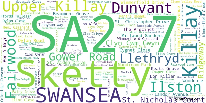
The largest settlement in the SA2 7 postal code is KILLAY followed by Dunvant, and UPPER KILLAY.
The SA2 7 Postcode shares a border with SA2 9 (SKETTY), SA2 8 (SKETTY), SA3 1 (REYNOLDSTON, LLANRHIDIAN, OXWICH), SA3 2 (SOUTHGATE, PARKMILL, PENMAEN), SA3 3 (Bishopston, MURTON, KITTLE), SA3 5 (WEST CROSS, MAYALS, BLACKPILL), SA4 3 (Gowerton, PENCLAWDD, THREE CROSSES) and SA5 4 (FFORESTFACH, WAUNARLWYDD, CADLE).
The sector is within the post town of SWANSEA.
SA2 7 is a postcode sector within the SA2 postcode district which is within the SA Swansea postcode area.
The Royal Mail delivery office for the SA2 7 postal sector is the Swansea Delivery Office.
The area of the SA2 7 postcode sector is 9.40 square miles which is 24.36 square kilometres or 6,018.45 square acres.

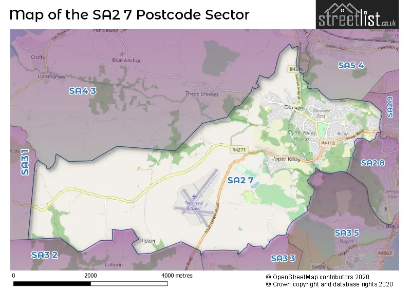
Map of the SA2 7 Postcode Sector
Explore the SA2 7 postcode sector by using our free interactive map.
| S | A | 2 | - | 7 | X | X |
| S | A | 2 | Space | 7 | Letter | Letter |
Official List of Streets
Killay (55 Streets)
Upper Killay (12 Streets)
Fairwood (2 Streets)
Dunvant (51 Streets)
Sketty (14 Streets)
SWANSEA (1 Streets)
Unofficial Streets or Alternative Spellings
Killay
ST. NICHOLAS COURTGowerton
CECIL ROADSketty
OLCHFA LANE PARK WAY ARETHUSA COURT BRON-Y-BRYN BRYN AERON CLYNE CYCLE PATH CLYNE VALLEY COTTAGES DOL-Y-COED GOETRE BELLAF GRAIG-Y-BWLDAN HEASELANDS PLACE HENDRE-FOILAN ROAD LLYS-TEG MAES-YR-EFAIL PEN-Y-FRO PEN-Y-FRO CLOSE SAINT CHRISTOPHER DRIVE STEPHENSON ROAD SUNNYBANKDunvant
CWM-YR-WCHThree Crosses
DUNVANT ROADKittle
KITTLE HILL LANEReynoldston
SOUTH GOWER ROADWeather Forecast for SA2 7
Press Button to Show Forecast for Gowerton
| Time Period | Icon | Description | Temperature | Rain Probability | Wind |
|---|---|---|---|---|---|
| 06:00 to 09:00 | Cloudy | 6.0°C (feels like 6.0°C) | 12.00% | SW 2 mph | |
| 09:00 to 12:00 | Cloudy | 9.0°C (feels like 7.0°C) | 7.00% | NW 9 mph | |
| 12:00 to 15:00 | Cloudy | 11.0°C (feels like 8.0°C) | 9.00% | NW 13 mph | |
| 15:00 to 18:00 | Cloudy | 11.0°C (feels like 9.0°C) | 4.00% | NW 11 mph | |
| 18:00 to 21:00 | Cloudy | 10.0°C (feels like 8.0°C) | 4.00% | NNW 11 mph | |
| 21:00 to 00:00 | Cloudy | 8.0°C (feels like 6.0°C) | 4.00% | NNW 7 mph |
Press Button to Show Forecast for Gowerton
| Time Period | Icon | Description | Temperature | Rain Probability | Wind |
|---|---|---|---|---|---|
| 00:00 to 03:00 | Cloudy | 6.0°C (feels like 5.0°C) | 4.00% | NNE 4 mph | |
| 03:00 to 06:00 | Cloudy | 6.0°C (feels like 5.0°C) | 4.00% | ENE 4 mph | |
| 06:00 to 09:00 | Cloudy | 6.0°C (feels like 4.0°C) | 6.00% | ENE 7 mph | |
| 09:00 to 12:00 | Cloudy | 8.0°C (feels like 6.0°C) | 8.00% | E 11 mph | |
| 12:00 to 15:00 | Cloudy | 10.0°C (feels like 7.0°C) | 11.00% | ESE 9 mph | |
| 15:00 to 18:00 | Cloudy | 11.0°C (feels like 9.0°C) | 12.00% | ESE 9 mph | |
| 18:00 to 21:00 | Cloudy | 11.0°C (feels like 9.0°C) | 13.00% | E 7 mph | |
| 21:00 to 00:00 | Cloudy | 9.0°C (feels like 7.0°C) | 11.00% | ENE 9 mph |
Press Button to Show Forecast for Gowerton
| Time Period | Icon | Description | Temperature | Rain Probability | Wind |
|---|---|---|---|---|---|
| 00:00 to 03:00 | Cloudy | 8.0°C (feels like 5.0°C) | 13.00% | ENE 9 mph | |
| 03:00 to 06:00 | Cloudy | 7.0°C (feels like 4.0°C) | 10.00% | ENE 11 mph | |
| 06:00 to 09:00 | Cloudy | 7.0°C (feels like 4.0°C) | 10.00% | ENE 11 mph | |
| 09:00 to 12:00 | Cloudy | 9.0°C (feels like 6.0°C) | 11.00% | ENE 13 mph | |
| 12:00 to 15:00 | Overcast | 11.0°C (feels like 8.0°C) | 14.00% | ENE 11 mph | |
| 15:00 to 18:00 | Overcast | 11.0°C (feels like 9.0°C) | 18.00% | ENE 11 mph | |
| 18:00 to 21:00 | Cloudy | 11.0°C (feels like 9.0°C) | 12.00% | NE 11 mph | |
| 21:00 to 00:00 | Overcast | 10.0°C (feels like 7.0°C) | 20.00% | NNE 11 mph |
Press Button to Show Forecast for Gowerton
| Time Period | Icon | Description | Temperature | Rain Probability | Wind |
|---|---|---|---|---|---|
| 00:00 to 03:00 | Overcast | 9.0°C (feels like 6.0°C) | 17.00% | NNE 11 mph | |
| 03:00 to 06:00 | Light rain | 8.0°C (feels like 5.0°C) | 45.00% | N 11 mph | |
| 06:00 to 09:00 | Light rain | 8.0°C (feels like 5.0°C) | 51.00% | N 11 mph | |
| 09:00 to 12:00 | Light rain shower (day) | 9.0°C (feels like 6.0°C) | 40.00% | N 13 mph | |
| 12:00 to 15:00 | Cloudy | 11.0°C (feels like 8.0°C) | 19.00% | NNW 16 mph | |
| 15:00 to 18:00 | Cloudy | 12.0°C (feels like 9.0°C) | 15.00% | NNW 13 mph | |
| 18:00 to 21:00 | Sunny day | 11.0°C (feels like 8.0°C) | 8.00% | NW 13 mph | |
| 21:00 to 00:00 | Clear night | 9.0°C (feels like 7.0°C) | 5.00% | WNW 9 mph |
House Prices in the SA2 7 Postcode Sector
| Type of Property | 2018 Average | 2018 Sales | 2017 Average | 2017 Sales | 2016 Average | 2016 Sales | 2015 Average | 2015 Sales |
|---|---|---|---|---|---|---|---|---|
| Detached | £281,484 | 71 | £269,513 | 71 | £240,566 | 68 | £215,304 | 45 |
| Semi-Detached | £166,736 | 102 | £170,967 | 114 | £162,587 | 71 | £159,389 | 70 |
| Terraced | £149,415 | 29 | £168,524 | 19 | £130,108 | 18 | £126,233 | 13 |
| Flats | £130,000 | 1 | £129,600 | 5 | £107,667 | 6 | £121,833 | 6 |
Important Postcodes SA2 7 in the Postcode Sector
SA2 7AB is the postcode for MAIN BLOCK, Olchfa Comprehensive School, Gower Road
SA2 7DA is the postcode for Ty-Cila, Wimmerfield Avenue, Killay, and Ty-Cila, Wimmerfield Avenue
SA2 7DR is the postcode for Cila Primary School, 577 Gower Road
SA2 7JX is the postcode for Fairwood Playing Fields, Fairwood
SA2 7LF is the postcode for MAIN BLOCK, Hendrefoilan Primary School, Dunvant Road
SA2 7NB is the postcode for SOUTH WALES MINERS LIBRARY, Hendrefoilan House, Hendrefoilan Avenue, EMILY PHIPPS BUILDING, Hendrefoilan House, Hendrefoilan Avenue, and Hendrefoilan House, Hendrefoilan Avenue
SA2 7PG is the postcode for 40, Student Village, Gower Road
SA2 7QL is the postcode for HOUSE 151-159, 136-165, Student Village, Gower Road, HOUSE 145-150, 136-165, Student Village, Gower Road, HOUSE 136-144, 136-165, Student Village, Gower Road, and HOUSE 160-165, 136-165, Student Village, Gower Road
SA2 7QN is the postcode for HOUSE 187-195, 166-195, Student Village, Gower Road, HOUSE 166-171, 166-195, Student Village, Gower Road, HOUSE 178-186, 166-195, Student Village, Gower Road, 166-195, Student Village, Gower Road, and HOUSE 172-177, 166-195, Student Village, Gower Road
SA2 7QW is the postcode for HOUSE 196-204, 196-233, Student Village, Gower Road, HOUSE 205-210, 196-233, Student Village, Gower Road, HOUSE 211-219, 196-233, Student Village, Gower Road, and HOUSE 228-233, 196-233, Student Village, Gower Road
SA2 7SN is the postcode for INFANT BLOCK, Dunvant Primary School, Dunvant Road, and JUNIOR BLOCK, Dunvant Primary School, Dunvant Road
SA2 7UF is the postcode for Pen y Fro Primary School, Priors Crescent
| The SA2 7 Sector is within these Local Authorities |
|
|---|---|
| The SA2 7 Sector is within these Counties |
|
| The SA2 7 Sector is within these Water Company Areas |
|