The SA20 postcode district is a postal district located in the SA Swansea postcode area with a population of 3,341 residents according to the 2021 England and Wales Census.
The area of the SA20 postcode district is 95.67 square miles which is 247.79 square kilometres or 61,230.10 acres.
Currently, the SA20 district has about 236 postcode units spread across 1 geographic postcode sectors.
Given that each sector allows for 400 unique postcode combinations, the district has a capacity of 400 postcodes. With 236 postcodes already in use, this leaves 164 units available.
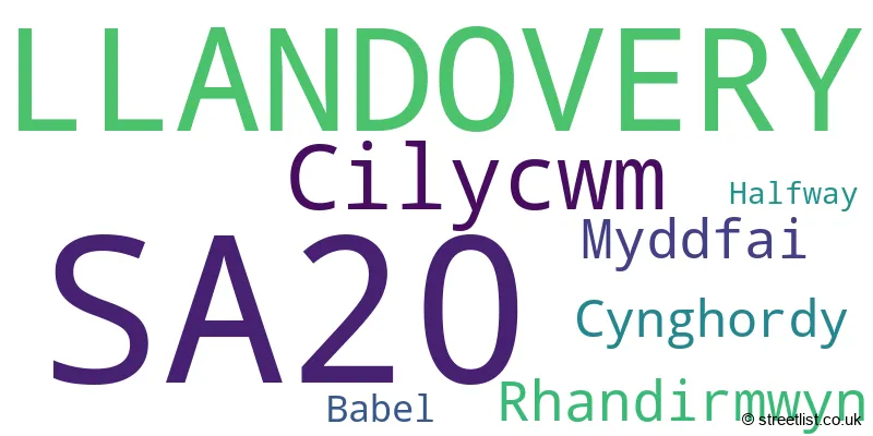
The largest settlement in the SA20 postal code is LLANDOVERY followed by RHANDIRMWYN, and CYNGHORDY.
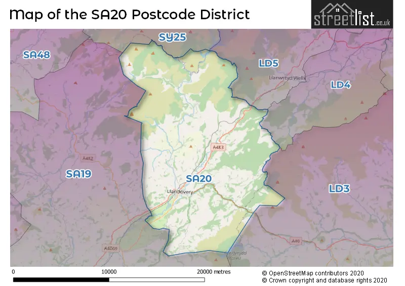
The SA20 Postcode shares a border with SY25 (TREGARON, PONTRHYDFENDIGAID, LLANDDEWI BREFI), LD3 (BRECON, TALGARTH, LLAN-FAES), LD4 (LLANGAMMARCH WELLS, GARTH, TIRABAD), LD5 (LLANWRTYD WELLS, BEULAH, ABERGWESYN) and SA19 (LLANDEILO, LLANGADOG, FFAIRFACH).
The primary settlement in the SA20 postcode district is Llandovery, which is located in the county of Dyfed in Wales. Other significant settlements in the district, in order of importance, include Babel, Cilycwm, Cynghordy, Halfway, Myddfai, and Rhandirmwyn. The main post town in the district is also Llandovery.
For the district SA20, we have data on 1 postcode sectors. Here's a breakdown: The sector SA20 0, covers Llandovery and Cilycwm and Rhandirmwyn in Dyfed.
SA20 Postcode Sectors

Map of the SA20 Postcode District
Explore the SA20 postcode district by using our free interactive map.
When it comes to local government, postal geography often disregards political borders. However, for a breakdown in the SA20 District: the district mostly encompasses the Sir Gaerfyrddin - Carmarthenshire area with a total of 237 postcodes.
Recent House Sales in SA20
| Date | Price | Address |
|---|---|---|
| 07/08/2023 | £520,000 | Cynghordy, Llandovery, SA20 0LF |
| 28/07/2023 | £126,000 | Maesglas, Llandovery, SA20 0DW |
| 28/07/2023 | £220,000 | Halfway, Llandovery, SA20 0SD |
| 20/07/2023 | £275,000 | Stone Street, Llandovery, SA20 0BZ |
| 07/07/2023 | £125,000 | Bridge Street, Llandovery, SA20 0DS |
| 30/06/2023 | £200,000 | Cynghordy, Llandovery, SA20 0LS |
| 28/06/2023 | £795,000 | Cilycwm, Llandovery, SA20 0TE |
| 19/05/2023 | £138,000 | Orchard Street, Llandovery, SA20 0DG |
| 12/04/2023 | £205,000 | Stone Street, Llandovery, SA20 0JR |
| 12/04/2023 | £350,000 | Maes Y Coleg, Llandovery, SA20 0HS |
Weather Forecast for SA20
Press Button to Show Forecast for Llandovery
| Time Period | Icon | Description | Temperature | Rain Probability | Wind |
|---|---|---|---|---|---|
| 21:00 to 00:00 | Clear night | 6.0°C (feels like 4.0°C) | 4.00% | NW 7 mph |
Press Button to Show Forecast for Llandovery
| Time Period | Icon | Description | Temperature | Rain Probability | Wind |
|---|---|---|---|---|---|
| 00:00 to 03:00 | Heavy rain shower (night) | 6.0°C (feels like 4.0°C) | 60.00% | NW 4 mph | |
| 03:00 to 06:00 | Light rain shower (night) | 5.0°C (feels like 3.0°C) | 39.00% | NNW 7 mph | |
| 06:00 to 09:00 | Cloudy | 5.0°C (feels like 2.0°C) | 49.00% | NNW 7 mph | |
| 09:00 to 12:00 | Overcast | 7.0°C (feels like 4.0°C) | 15.00% | NNW 11 mph | |
| 12:00 to 15:00 | Overcast | 9.0°C (feels like 6.0°C) | 10.00% | NNW 13 mph | |
| 15:00 to 18:00 | Light rain | 8.0°C (feels like 5.0°C) | 59.00% | NW 11 mph | |
| 18:00 to 21:00 | Light rain | 7.0°C (feels like 5.0°C) | 60.00% | NW 4 mph | |
| 21:00 to 00:00 | Partly cloudy (night) | 6.0°C (feels like 4.0°C) | 11.00% | N 4 mph |
Press Button to Show Forecast for Llandovery
| Time Period | Icon | Description | Temperature | Rain Probability | Wind |
|---|---|---|---|---|---|
| 00:00 to 03:00 | Clear night | 3.0°C (feels like 1.0°C) | 3.00% | NNE 4 mph | |
| 03:00 to 06:00 | Clear night | 1.0°C (feels like 0.0°C) | 2.00% | NNE 2 mph | |
| 06:00 to 09:00 | Sunny day | 2.0°C (feels like 1.0°C) | 1.00% | NNE 4 mph | |
| 09:00 to 12:00 | Partly cloudy (day) | 8.0°C (feels like 8.0°C) | 1.00% | W 2 mph | |
| 12:00 to 15:00 | Overcast | 11.0°C (feels like 9.0°C) | 12.00% | W 7 mph | |
| 15:00 to 18:00 | Overcast | 11.0°C (feels like 8.0°C) | 15.00% | W 11 mph | |
| 18:00 to 21:00 | Cloudy | 10.0°C (feels like 7.0°C) | 9.00% | W 11 mph | |
| 21:00 to 00:00 | Overcast | 9.0°C (feels like 6.0°C) | 18.00% | W 9 mph |
Press Button to Show Forecast for Llandovery
| Time Period | Icon | Description | Temperature | Rain Probability | Wind |
|---|---|---|---|---|---|
| 00:00 to 03:00 | Cloudy | 9.0°C (feels like 7.0°C) | 12.00% | WNW 11 mph | |
| 03:00 to 06:00 | Overcast | 9.0°C (feels like 6.0°C) | 12.00% | WNW 11 mph | |
| 06:00 to 09:00 | Overcast | 9.0°C (feels like 6.0°C) | 11.00% | NW 11 mph | |
| 09:00 to 12:00 | Overcast | 10.0°C (feels like 7.0°C) | 9.00% | NNW 16 mph | |
| 12:00 to 15:00 | Overcast | 11.0°C (feels like 8.0°C) | 10.00% | NNW 16 mph | |
| 15:00 to 18:00 | Cloudy | 11.0°C (feels like 8.0°C) | 5.00% | NNW 18 mph | |
| 18:00 to 21:00 | Sunny day | 10.0°C (feels like 8.0°C) | 2.00% | NNW 13 mph | |
| 21:00 to 00:00 | Clear night | 7.0°C (feels like 5.0°C) | 1.00% | NNW 9 mph |
Press Button to Show Forecast for Llandovery
| Time Period | Icon | Description | Temperature | Rain Probability | Wind |
|---|---|---|---|---|---|
| 00:00 to 03:00 | Clear night | 5.0°C (feels like 3.0°C) | 1.00% | N 4 mph | |
| 03:00 to 06:00 | Clear night | 4.0°C (feels like 2.0°C) | 1.00% | N 4 mph | |
| 06:00 to 09:00 | Sunny day | 5.0°C (feels like 3.0°C) | 1.00% | NNE 4 mph | |
| 09:00 to 12:00 | Sunny day | 10.0°C (feels like 9.0°C) | 1.00% | N 4 mph | |
| 12:00 to 15:00 | Partly cloudy (day) | 13.0°C (feels like 12.0°C) | 2.00% | N 7 mph | |
| 15:00 to 18:00 | Partly cloudy (day) | 14.0°C (feels like 13.0°C) | 2.00% | NW 7 mph | |
| 18:00 to 21:00 | Partly cloudy (day) | 12.0°C (feels like 10.0°C) | 1.00% | NNW 7 mph | |
| 21:00 to 00:00 | Clear night | 7.0°C (feels like 6.0°C) | 1.00% | N 4 mph |
Where is the SA20 Postcode District?
The data provided reveals that the postcode district SA20 is located in Llandovery. This town is surrounded by various nearby towns: Llanwrda is situated in the South West at a distance of approximately 5.95 miles, Llanwrtyd Wells in the North East at around 7.66 miles, Lampeter in the North West at a distance of approximately 14.42 miles, Llanybydder in the West at around 15.95 miles, and Builth Wells in the East at a distance of approximately 17.76 miles. Additionally, the centre of London is approximately 160.49 miles away from this postcode district.
The district is within the post town of LLANDOVERY.
The sector has postcodes within the nation of Wales.
The SA20 Postcode District is in the South West Wales region of West Wales within the Wales.
Postcode Sectors within the SA20 District
| Postcode Sector | Delivery Office |
|---|---|
| SA20 0 | Llandovery Delivery Office |
| S | A | 2 | 0 | - | X | X | X |
| S | A | 2 | 0 | Space | Numeric | Letter | Letter |
Tourist Attractions within the Postcode Area
We found 1 visitor attractions within the SA20 postcode area
| Myddfai Community Hall and Visitor Centre |
|---|
| View Myddfai Community Hall and Visitor Centre on Google Maps |
Current Monthly Rental Prices
| # Bedrooms | Min Price | Max Price | Avg Price |
|---|
Current House Prices
| # Bedrooms | Min Price | Max Price | Avg Price |
|---|---|---|---|
| £145,000 | £681,000 | £336,100 | |
| 2 | £119,000 | £220,000 | £166,000 |
| 3 | £142,000 | £1,100,000 | £390,744 |
| 4 | £289,000 | £625,000 | £432,994 |
| 5 | £335,000 | £360,000 | £347,500 |
| 7 | £950,000 | £950,000 | £950,000 |
Estate Agents who Operate in the SA20 District
| Logo | Name | Brand Name | Address | Contact Number | Total Properties |
|---|---|---|---|---|---|
 | Llandovery | Clee Tompkinson & Francis | 3 Kings Road, Llandovery, SA20 0AW | 01550 912275 | 19 |
 | Lampeter | Morgan & Davies | 12 Harford Square, Lampeter, SA48 7DT | 01570 940145 | 4 |
 | Brecon | Fine & Country | 40 High Street, Brecon, LD3 7AP | 01874 641300 | 3 |
 | Lampeter | Evans Bros | 39 High Street, Lampeter, SA48 7BB | 01570 940421 | 2 |
 | Llanwrda | Davies Morgan and Partners | Gelli Newydd Llanwrda Carmarthenshire SA19 8HD | 01558 611161 | 2 |
| Type of Property | 2018 Average | 2018 Sales | 2017 Average | 2017 Sales | 2016 Average | 2016 Sales | 2015 Average | 2015 Sales |
|---|---|---|---|---|---|---|---|---|
| Detached | £282,532 | 22 | £217,454 | 23 | £251,168 | 28 | £226,955 | 11 |
| Semi-Detached | £106,283 | 9 | £125,818 | 11 | £152,571 | 7 | £167,100 | 5 |
| Terraced | £106,646 | 12 | £105,615 | 13 | £121,381 | 21 | £94,470 | 17 |
| Flats | £55,000 | 1 | £0 | 0 | £0 | 0 | £0 | 0 |
Hotels within the Postcode Area
We found 14 hotels and guest houses within the SA20 postcode area
Llanerchindda Farm Guest House
Cynghordy, Llandovery, Carmarthenshire, cynghordy, SA20 0NB.
View detailsY Neuadd Country House B&B
Y Neuadd Country House B and B Pentre ty Gwyn, Llandovery, llandovery, SA20 0RN.
View details