The SA69 postcode district is a postal district located in the SA Swansea postcode area with a population of 3,646 residents according to the 2021 England and Wales Census.
The area of the SA69 postcode district is 4.82 square miles which is 12.48 square kilometres or 3,084.26 acres.
Currently, the SA69 district has about 156 postcode units spread across 1 geographic postcode sectors.
Given that each sector allows for 400 unique postcode combinations, the district has a capacity of 400 postcodes. With 156 postcodes already in use, this leaves 244 units available.
The largest settlement in the SA69 postal code is SAUNDERSFOOT followed by PENTLEPOIR, and WOODEN.
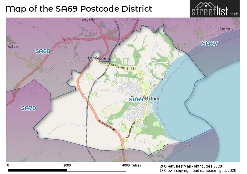
The postcode area has a boundary with The Bristol Channel.
The SA69 Postcode shares a border with SA68 (KILGETTY, BEGELLY, CRESSELLY), SA67 (NARBERTH, TEMPLETON, STEPASIDE) and SA70 (TENBY, PENALLY, MANORBIER).
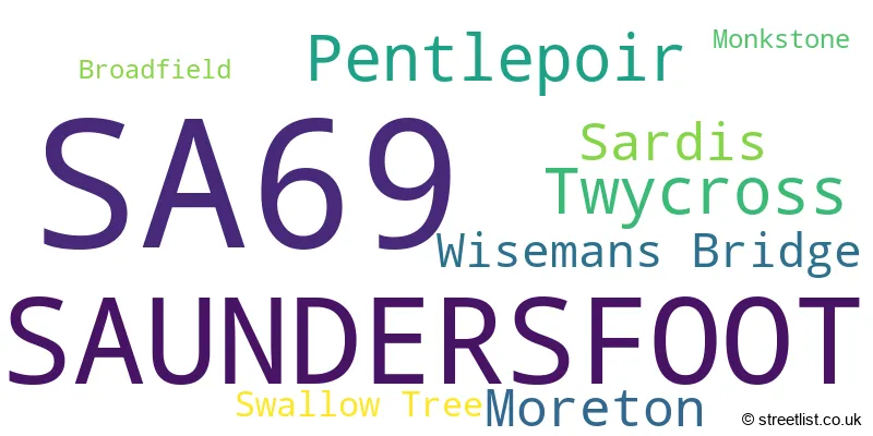
The primary settlement in the SA69 postcode district is Saundersfoot, located in the county of Dyfed, Wales. Other significant settlements in the area include Broadfield, Monkstone, Moreton, Pentlepoir, Sardis, Swallow Tree, Twycross, and Wisemans Bridge. The most significant post town in this district is Saundersfoot.
For the district SA69, we have data on 1 postcode sectors. Here's a breakdown: The sector SA69 9, covers Saundersfoot in Dyfed.
SA69 Postcode Sectors

Map of the SA69 Postcode District
Explore the SA69 postcode district by using our free interactive map.
When it comes to local government, postal geography often disregards political borders. However, for a breakdown in the SA69 District: the district mostly encompasses the Sir Benfro - Pembrokeshire area with a total of 155 postcodes.
Recent House Sales in SA69
| Date | Price | Address |
|---|---|---|
| 20/10/2023 | £435,000 | Scandinavia Heights, Saundersfoot, SA69 9PE |
| 19/10/2023 | £448,500 | Castle View, Saundersfoot, SA69 9AB |
| 19/10/2023 | £310,000 | Sandy Hill Park, Saundersfoot, SA69 9PH |
| 29/09/2023 | £397,500 | Scandinavia Heights, Saundersfoot, SA69 9PF |
| 29/08/2023 | £300,000 | Sandy Hill Park, Saundersfoot, SA69 9PJ |
| 10/08/2023 | £205,000 | St Brides Hill, Saundersfoot, SA69 9NU |
| 09/08/2023 | £250,000 | Bonvilles Close, Saundersfoot, SA69 9LY |
| 09/08/2023 | £320,000 | Rusheylake, Saundersfoot, SA69 9NY |
| 09/08/2023 | £80,000 | The Ridgeway, Saundersfoot, SA69 9LR |
| 07/08/2023 | £440,000 | Stammers Road, Saundersfoot, SA69 9HZ |
Weather Forecast for SA69
Press Button to Show Forecast for Saundersfoot
| Time Period | Icon | Description | Temperature | Rain Probability | Wind |
|---|---|---|---|---|---|
| 00:00 to 03:00 | Clear night | 5.0°C (feels like 2.0°C) | 1.00% | N 9 mph | |
| 03:00 to 06:00 | Partly cloudy (night) | 4.0°C (feels like 1.0°C) | 14.00% | N 7 mph | |
| 06:00 to 09:00 | Mist | 3.0°C (feels like 1.0°C) | 16.00% | NNE 4 mph | |
| 09:00 to 12:00 | Sunny day | 9.0°C (feels like 8.0°C) | 1.00% | S 4 mph | |
| 12:00 to 15:00 | Cloudy | 11.0°C (feels like 9.0°C) | 8.00% | WSW 9 mph | |
| 15:00 to 18:00 | Cloudy | 11.0°C (feels like 8.0°C) | 5.00% | W 13 mph | |
| 18:00 to 21:00 | Cloudy | 10.0°C (feels like 7.0°C) | 5.00% | WSW 13 mph | |
| 21:00 to 00:00 | Partly cloudy (night) | 9.0°C (feels like 6.0°C) | 1.00% | W 13 mph |
Press Button to Show Forecast for Saundersfoot
| Time Period | Icon | Description | Temperature | Rain Probability | Wind |
|---|---|---|---|---|---|
| 00:00 to 03:00 | Partly cloudy (night) | 9.0°C (feels like 7.0°C) | 1.00% | WNW 11 mph | |
| 03:00 to 06:00 | Cloudy | 9.0°C (feels like 6.0°C) | 4.00% | WNW 13 mph | |
| 06:00 to 09:00 | Overcast | 9.0°C (feels like 6.0°C) | 16.00% | NW 13 mph | |
| 09:00 to 12:00 | Cloudy | 11.0°C (feels like 8.0°C) | 5.00% | NNW 18 mph | |
| 12:00 to 15:00 | Cloudy | 12.0°C (feels like 8.0°C) | 6.00% | NNW 18 mph | |
| 15:00 to 18:00 | Sunny day | 12.0°C (feels like 9.0°C) | 3.00% | NNW 18 mph | |
| 18:00 to 21:00 | Partly cloudy (day) | 10.0°C (feels like 8.0°C) | 2.00% | N 11 mph | |
| 21:00 to 00:00 | Clear night | 8.0°C (feels like 5.0°C) | 2.00% | N 9 mph |
Press Button to Show Forecast for Saundersfoot
| Time Period | Icon | Description | Temperature | Rain Probability | Wind |
|---|---|---|---|---|---|
| 00:00 to 03:00 | Clear night | 7.0°C (feels like 4.0°C) | 2.00% | N 9 mph | |
| 03:00 to 06:00 | Clear night | 6.0°C (feels like 3.0°C) | 1.00% | N 9 mph | |
| 06:00 to 09:00 | Sunny day | 6.0°C (feels like 4.0°C) | 1.00% | N 7 mph | |
| 09:00 to 12:00 | Partly cloudy (day) | 10.0°C (feels like 9.0°C) | 2.00% | NNE 7 mph | |
| 12:00 to 15:00 | Partly cloudy (day) | 12.0°C (feels like 10.0°C) | 2.00% | N 7 mph | |
| 15:00 to 18:00 | Partly cloudy (day) | 12.0°C (feels like 10.0°C) | 1.00% | NNW 9 mph | |
| 18:00 to 21:00 | Sunny day | 10.0°C (feels like 8.0°C) | 1.00% | NNW 9 mph | |
| 21:00 to 00:00 | Clear night | 7.0°C (feels like 5.0°C) | 0.00% | N 7 mph |
Press Button to Show Forecast for Saundersfoot
| Time Period | Icon | Description | Temperature | Rain Probability | Wind |
|---|---|---|---|---|---|
| 00:00 to 03:00 | Clear night | 6.0°C (feels like 4.0°C) | 0.00% | NE 7 mph | |
| 03:00 to 06:00 | Clear night | 6.0°C (feels like 4.0°C) | 1.00% | ENE 7 mph | |
| 06:00 to 09:00 | Sunny day | 6.0°C (feels like 4.0°C) | 0.00% | ENE 7 mph | |
| 09:00 to 12:00 | Sunny day | 10.0°C (feels like 9.0°C) | 0.00% | E 4 mph | |
| 12:00 to 15:00 | Cloudy | 13.0°C (feels like 12.0°C) | 3.00% | E 7 mph | |
| 15:00 to 18:00 | Partly cloudy (day) | 13.0°C (feels like 12.0°C) | 2.00% | NE 9 mph | |
| 18:00 to 21:00 | Sunny day | 12.0°C (feels like 10.0°C) | 1.00% | NNW 9 mph | |
| 21:00 to 00:00 | Clear night | 8.0°C (feels like 6.0°C) | 1.00% | N 9 mph |
Where is the SA69 Postcode District?
The postcode district SA69 is located in the town of Saundersfoot. Saundersfoot is a district town situated in Pembrokeshire, Wales. It is surrounded by several nearby towns. To the North West of Saundersfoot is Kilgetty, located at a distance of approximately 1.3 miles. To the South West is Tenby, around 3.2 miles away. Narberth is situated to the North of Saundersfoot and is approximately 5.3 miles away. Pembroke Dock is situated to the West, around 8.7 miles away. Finally, Whitland is located to the North East, about 8.9 miles away. Furthermore, the distance from Saundersfoot to the center of London is approximately 197.9 miles.
The district is within the post town of SAUNDERSFOOT.
The sector has postcodes within the nation of Wales.
The SA69 Postcode District is in the South West Wales region of West Wales within the Wales.
Postcode Sectors within the SA69 District
| Postcode Sector | Delivery Office |
|---|---|
| SA69 9 | Tenby Delivery Office |
| S | A | 6 | 9 | - | X | X | X |
| S | A | 6 | 9 | Space | Numeric | Letter | Letter |
Current Monthly Rental Prices
| # Bedrooms | Min Price | Max Price | Avg Price |
|---|
Current House Prices
| # Bedrooms | Min Price | Max Price | Avg Price |
|---|---|---|---|
| £100,000 | £700,000 | £400,000 | |
| 1 | £189,950 | £199,950 | £194,950 |
| 2 | £125,000 | £525,000 | £278,472 |
| 3 | £200,000 | £1,500,000 | £450,414 |
| 4 | £350,000 | £695,000 | £504,250 |
| 5 | £465,000 | £950,000 | £638,333 |
| 6 | £595,000 | £595,000 | £595,000 |
| 9 | £650,000 | £900,000 | £775,000 |
Estate Agents who Operate in the SA69 District
| Logo | Name | Brand Name | Address | Contact Number | Total Properties |
|---|---|---|---|---|---|
 | Tenby | John Francis | 2 Cheltenham House Tudor Square Tenby SA70 7AD | 01834 820832 | 23 |
 | Tenby | Birt & Co | Lock House St. Julians Street, Tenby, SA70 7AS | 01832 777012 | 11 |
 | Tenby | FBM | St Julian Street Penally, Tenby, SA70 7AS | 01834 824079 | 10 |
 | Tenby | West Wales Properties | Nat West Chamber, Tudor Square, Tenby, SA70 7AJ | 01834 820690 | 7 |
 | Tenby | Chandler Rogers | Boston house Upper Frog Street Tenby SA70 7JG | 01834 820656 | 7 |
| Type of Property | 2018 Average | 2018 Sales | 2017 Average | 2017 Sales | 2016 Average | 2016 Sales | 2015 Average | 2015 Sales |
|---|---|---|---|---|---|---|---|---|
| Detached | £285,564 | 42 | £314,594 | 43 | £277,216 | 53 | £276,841 | 64 |
| Semi-Detached | £198,495 | 29 | £218,295 | 11 | £162,053 | 18 | £185,224 | 33 |
| Terraced | £215,182 | 11 | £249,556 | 9 | £179,550 | 9 | £276,917 | 14 |
| Flats | £159,038 | 12 | £147,531 | 16 | £154,364 | 11 | £198,045 | 11 |
Hotels within the Postcode Area
We found 16 hotels and guest houses within the SA69 postcode area
Harbourlight Guesthouse
2 High Street, Saundersfoot Village, Tenby, saundersfoot-aireborough, SA69 9EJ.
View detailsStoney Bridge Luxury B&B
Stoney Bridge, Moreton, Saundersfoot, saundersfoot-aireborough, SA69 9DX.
View detailsMerlewood Hotel
St. Brides Hill, Saundersfoot, Nr Tenby, saundersfoot-aireborough, SA69 9NP.
View detailsStrandways Court Apartment
Flat 2, Strandways Court, The Strand, Saundersfoot, saundersfoot-aireborough, SA69 9EY.
View details