The SA72 postcode district is a postal district located in the SA Swansea postcode area with a population of 10,433 residents according to the 2021 England and Wales Census.
The area of the SA72 postcode district is 7.17 square miles which is 18.58 square kilometres or 4,591.75 acres.
Currently, the SA72 district has about 306 postcode units spread across 2 geographic postcode sectors.
Given that each sector allows for 400 unique postcode combinations, the district has a capacity of 800 postcodes. With 306 postcodes already in use, this leaves 494 units available.
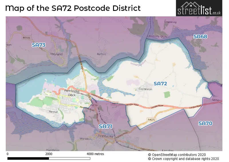
The largest settlement in the SA72 postal code is PEMBROKE DOCK followed by PENNAR, and COSHESTON.
The postcode area has a boundary with Milford Haven.
The SA72 Postcode shares a border with SA70 (TENBY, PENALLY, MANORBIER) and SA71 (PEMBROKE, MONKTON, FRESHWATER EAST).
The primary settlement in the SA72 postcode district is Pembroke Dock, located in the county of Dyfed in Wales. Other significant settlements in the district include Cosheston, Slade Cross, Llanreath, and Pennar. The most significant post town in the district is Pembroke Dock.
For the district SA72, we have data on 3 postcode sectors. Here's a breakdown: The sector SA72 4, covers Cosheston and Pembroke Dock in Dyfed. The sector SA72 6, covers Pembroke Dock and Pennar in Dyfed. The sector SA72 9 is non-geographic. It's often designated for PO Boxes, large organisations, or special services.


Map of the SA72 Postcode District
Explore the SA72 postcode district by using our free interactive map.
When it comes to local government, postal geography often disregards political borders. However, for a breakdown in the SA72 District: the district mostly encompasses the Sir Benfro - Pembrokeshire area with a total of 306 postcodes.
Recent House Sales in SA72
| Date | Price | Address |
|---|---|---|
| 23/10/2023 | £390,000 | Hampshire Drive, Pembroke Dock, SA72 6EQ |
| 13/10/2023 | £130,000 | Stranraer Road, Pennar, Pembroke Dock, SA72 6RX |
| 09/10/2023 | £153,000 | School Gardens, Pennar, Pembroke Dock, SA72 6SS |
| 27/09/2023 | £180,000 | Prospect Place, Pembroke Dock, SA72 6BB |
| 22/09/2023 | £80,000 | Beach Road, Llanreath, Pembroke Dock, SA72 6TP |
| 18/09/2023 | £142,000 | Clarence Street, Pembroke Dock, SA72 6JP |
| 08/09/2023 | £161,000 | Britannia Road, Pembroke Dock, SA72 6QE |
| 06/09/2023 | £198,000 | The Crescent, Pennar, Pembroke Dock, SA72 6GL |
| 25/08/2023 | £263,000 | St Patricks Hill, Llanreath, Pembroke Dock, SA72 6XQ |
| 18/08/2023 | £60,000 | Dimond Street East, Pembroke Dock, SA72 6HA |
Weather Forecast for SA72
Press Button to Show Forecast for Upton Gardens
| Time Period | Icon | Description | Temperature | Rain Probability | Wind |
|---|---|---|---|---|---|
| 18:00 to 21:00 | Cloudy | 9.0°C (feels like 7.0°C) | 5.00% | NNW 9 mph | |
| 21:00 to 00:00 | Cloudy | 7.0°C (feels like 6.0°C) | 4.00% | NNW 4 mph |
Press Button to Show Forecast for Upton Gardens
| Time Period | Icon | Description | Temperature | Rain Probability | Wind |
|---|---|---|---|---|---|
| 00:00 to 03:00 | Cloudy | 6.0°C (feels like 5.0°C) | 5.00% | N 4 mph | |
| 03:00 to 06:00 | Cloudy | 5.0°C (feels like 4.0°C) | 6.00% | NE 4 mph | |
| 06:00 to 09:00 | Cloudy | 6.0°C (feels like 4.0°C) | 8.00% | NE 4 mph | |
| 09:00 to 12:00 | Cloudy | 9.0°C (feels like 6.0°C) | 9.00% | ESE 9 mph | |
| 12:00 to 15:00 | Light rain shower (day) | 9.0°C (feels like 7.0°C) | 45.00% | ESE 9 mph | |
| 15:00 to 18:00 | Cloudy | 10.0°C (feels like 8.0°C) | 14.00% | E 7 mph | |
| 18:00 to 21:00 | Cloudy | 9.0°C (feels like 7.0°C) | 13.00% | NE 7 mph | |
| 21:00 to 00:00 | Cloudy | 7.0°C (feels like 5.0°C) | 10.00% | NE 7 mph |
Press Button to Show Forecast for Upton Gardens
| Time Period | Icon | Description | Temperature | Rain Probability | Wind |
|---|---|---|---|---|---|
| 00:00 to 03:00 | Cloudy | 6.0°C (feels like 4.0°C) | 10.00% | ENE 7 mph | |
| 03:00 to 06:00 | Cloudy | 5.0°C (feels like 2.0°C) | 9.00% | NE 9 mph | |
| 06:00 to 09:00 | Cloudy | 5.0°C (feels like 2.0°C) | 8.00% | NE 9 mph | |
| 09:00 to 12:00 | Partly cloudy (day) | 9.0°C (feels like 6.0°C) | 5.00% | ENE 11 mph | |
| 12:00 to 15:00 | Cloudy | 11.0°C (feels like 9.0°C) | 10.00% | NE 11 mph | |
| 15:00 to 18:00 | Cloudy | 11.0°C (feels like 9.0°C) | 13.00% | NE 11 mph | |
| 18:00 to 21:00 | Cloudy | 10.0°C (feels like 7.0°C) | 10.00% | NNE 13 mph | |
| 21:00 to 00:00 | Cloudy | 8.0°C (feels like 5.0°C) | 12.00% | NNE 11 mph |
Press Button to Show Forecast for Upton Gardens
| Time Period | Icon | Description | Temperature | Rain Probability | Wind |
|---|---|---|---|---|---|
| 00:00 to 03:00 | Cloudy | 7.0°C (feels like 4.0°C) | 10.00% | NNE 11 mph | |
| 03:00 to 06:00 | Cloudy | 6.0°C (feels like 3.0°C) | 18.00% | NNE 13 mph | |
| 06:00 to 09:00 | Cloudy | 7.0°C (feels like 3.0°C) | 14.00% | N 13 mph | |
| 09:00 to 12:00 | Cloudy | 9.0°C (feels like 6.0°C) | 13.00% | N 16 mph | |
| 12:00 to 15:00 | Partly cloudy (day) | 11.0°C (feels like 8.0°C) | 12.00% | N 16 mph | |
| 15:00 to 18:00 | Partly cloudy (day) | 11.0°C (feels like 8.0°C) | 11.00% | NNW 16 mph | |
| 18:00 to 21:00 | Sunny day | 10.0°C (feels like 8.0°C) | 8.00% | NNW 11 mph | |
| 21:00 to 00:00 | Clear night | 7.0°C (feels like 5.0°C) | 5.00% | WNW 9 mph |
Where is the SA72 Postcode District?
The data suggests that the SA72 postcode district is located in Pembroke Dock, a town in the southwest of the UK. Pembroke is approximately 2.65 miles southwest of Pembroke Dock, while Milford Haven is about 5.14 miles to the west. Goodwick is situated approximately 5.84 miles to the northwest. Tenby is located 6.94 miles to the east, and Narberth is about 9.55 miles to the northeast. Clarbeston Road is situated around 11.30 miles to the north. Furthermore, the SA72 postcode district is approximately 205.75 miles away from the center of London.
The district covers the post towns of PEMBROKE, PEMBROKE DOCK.
The sector has postcodes within the nation of Wales.
The SA72 Postcode District is in the South West Wales region of West Wales within the Wales.
| Postcode Sector | Delivery Office |
|---|---|
| SA72 4 | Pembroke Dock Delivery Office |
| SA72 6 | Pembroke Dock Delivery Office |
| S | A | 7 | 2 | - | X | X | X |
| S | A | 7 | 2 | Space | Numeric | Letter | Letter |
Current Monthly Rental Prices
| # Bedrooms | Min Price | Max Price | Avg Price |
|---|---|---|---|
| 2 | £500 | £500 | £500 |
| 3 | £750 | £750 | £750 |
| 4 | £900 | £900 | £900 |
Current House Prices
| # Bedrooms | Min Price | Max Price | Avg Price |
|---|---|---|---|
| £110,000 | £500,000 | £305,000 | |
| 1 | £60,000 | £60,000 | £60,000 |
| 2 | £49,950 | £145,000 | £98,540 |
| 3 | £90,000 | £315,000 | £175,381 |
| 4 | £110,000 | £350,000 | £228,050 |
| 5 | £195,000 | £385,000 | £313,333 |
| 6 | £220,000 | £1,500,000 | £860,000 |
| 11 | £1,400,000 | £1,400,000 | £1,400,000 |
Estate Agents who Operate in the SA72 District
| Logo | Name | Brand Name | Address | Contact Number | Total Properties |
|---|---|---|---|---|---|
 | Pembroke | FBM | 45-47 Main Street, Pembroke, SA71 4JS | 01642 967507 | 17 |
 | Pembroke | John Francis | 55 Main Street, Pembroke, SA71 4DA | 01646 405707 | 16 |
 | Pembroke | Guy Thomas & Co | 33 Main Street, Pembroke, Pembrokeshire, SA71 4JS | 01646 404078 | 11 |
 | Pembroke | West Wales Properties | Harlech House, 5 Main Street, Pembroke, SA71 4JS | 01646 405726 | 6 |
 | Haverfordwest | John Francis | 11 Victoria Place, Haverfordwest, SA61 2JX | 01437 457823 | 2 |
| Type of Property | 2018 Average | 2018 Sales | 2017 Average | 2017 Sales | 2016 Average | 2016 Sales | 2015 Average | 2015 Sales |
|---|---|---|---|---|---|---|---|---|
| Detached | £217,413 | 47 | £190,147 | 34 | £223,556 | 47 | £204,111 | 47 |
| Semi-Detached | £120,626 | 39 | £110,455 | 22 | £116,569 | 29 | £107,793 | 34 |
| Terraced | £107,638 | 69 | £105,756 | 72 | £97,663 | 69 | £109,320 | 74 |
| Flats | £58,437 | 8 | £64,041 | 12 | £59,786 | 7 | £68,750 | 4 |