The SE12 0 postcode sector is within the county of Greater London.
Did you know? According to the 2021 Census, the SE12 0 postcode sector is home to a bustling 9,427 residents!
Given that each sector allows for 400 unique postcode combinations. Letters C, I, K, M, O and V are not allowed in the last two letters of a postcode. With 180 postcodes already in use, this leaves 220 units available.
The largest settlements in the SE12 0 postal code are LONDON and GROVE PARK .
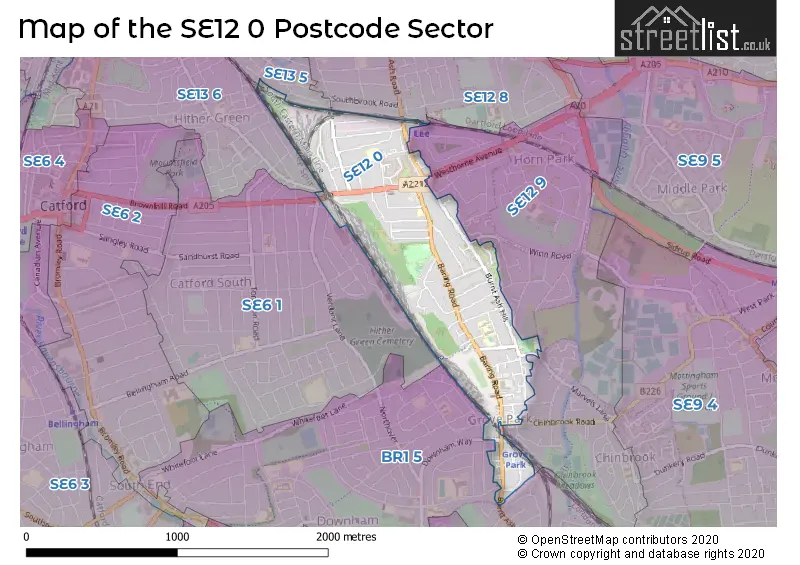
The SE12 0 Postcode shares a border with SE6 1 (LONDON , CATFORD ), SE12 8 (LONDON , ELTHAM , KIDBROOKE ), SE13 5 (LONDON , HITHER GREEN ), SE12 9 (GROVE PARK , LONDON , ELTHAM ), SE13 6 (HITHER GREEN , LEWISHAM , LONDON ) and BR1 5 (BROMLEY , LONDON ).
The sector is within the post town of LONDON.
SE12 0 is a postcode sector within the SE12 postcode district which is within the SE South Eastern London postcode area.
The Royal Mail delivery office for the SE12 0 postal sector is the Lee Sdelivery Office.
The area of the SE12 0 postcode sector is 0.61 square miles which is 1.57 square kilometres or 388.44 square acres.

Map of the SE12 0 Postcode Sector
Explore the SE12 0 postcode sector by using our free interactive map.
| S | E | 1 | 2 | - | 0 | X | X |
| S | E | 1 | 2 | Space | 0 | Letter | Letter |
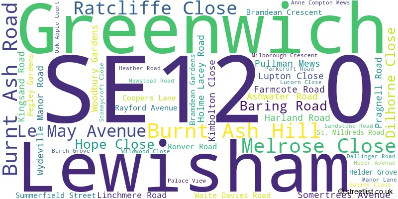
Official List of Streets
Lewisham (48 Streets)
Unofficial Streets or Alternative Spellings
Bromley
MARVELS LANELewisham
AMBLECOTE ROAD BALDER RISE CHINBROOK ROAD EXFORD ROAD FERNBROOK ROAD HITHER GREEN LANE SENLAC ROAD WOODYATES ROADGreenwich
WESTHORNE AVENUE WINN ROAD BARING CLOSE CEDAR COURT CHILTONIAN BUSINESS PARK DIANNE COURT ELLESMERE COURT EVERSFIELLD COURT HONEYSUCKLE COURT MAYFIELD NAPIER COURT NITA COURT RAILWAY CHILDREN WALK ST JOSEPHS COURT STATION APPROACH STRATFIELD HOUSEBROMLEY
BURNT ASH LANE DOWNHAM WAY LAUNCELOT ROADWeather Forecast for SE12 0
Press Button to Show Forecast for Lewisham
| Time Period | Icon | Description | Temperature | Rain Probability | Wind |
|---|---|---|---|---|---|
| 12:00 to 15:00 | Cloudy | 11.0°C (feels like 8.0°C) | 10.00% | W 11 mph | |
| 15:00 to 18:00 | Cloudy | 11.0°C (feels like 9.0°C) | 50.00% | W 9 mph | |
| 18:00 to 21:00 | Light rain | 9.0°C (feels like 7.0°C) | 54.00% | NNW 7 mph | |
| 21:00 to 00:00 | Cloudy | 8.0°C (feels like 6.0°C) | 12.00% | ENE 7 mph |
Press Button to Show Forecast for Lewisham
| Time Period | Icon | Description | Temperature | Rain Probability | Wind |
|---|---|---|---|---|---|
| 00:00 to 03:00 | Cloudy | 7.0°C (feels like 5.0°C) | 5.00% | ENE 7 mph | |
| 03:00 to 06:00 | Cloudy | 6.0°C (feels like 4.0°C) | 5.00% | NE 7 mph | |
| 06:00 to 09:00 | Cloudy | 5.0°C (feels like 3.0°C) | 5.00% | NE 7 mph | |
| 09:00 to 12:00 | Cloudy | 8.0°C (feels like 6.0°C) | 5.00% | ENE 7 mph | |
| 12:00 to 15:00 | Cloudy | 10.0°C (feels like 9.0°C) | 11.00% | ENE 7 mph | |
| 15:00 to 18:00 | Cloudy | 11.0°C (feels like 10.0°C) | 13.00% | ENE 7 mph | |
| 18:00 to 21:00 | Cloudy | 10.0°C (feels like 9.0°C) | 13.00% | E 7 mph | |
| 21:00 to 00:00 | Cloudy | 8.0°C (feels like 6.0°C) | 11.00% | E 7 mph |
Press Button to Show Forecast for Lewisham
| Time Period | Icon | Description | Temperature | Rain Probability | Wind |
|---|---|---|---|---|---|
| 00:00 to 03:00 | Cloudy | 6.0°C (feels like 4.0°C) | 17.00% | ENE 7 mph | |
| 03:00 to 06:00 | Cloudy | 5.0°C (feels like 3.0°C) | 18.00% | NE 7 mph | |
| 06:00 to 09:00 | Cloudy | 6.0°C (feels like 4.0°C) | 17.00% | ENE 7 mph | |
| 09:00 to 12:00 | Overcast | 10.0°C (feels like 8.0°C) | 18.00% | ENE 9 mph | |
| 12:00 to 15:00 | Cloudy | 12.0°C (feels like 10.0°C) | 14.00% | E 9 mph | |
| 15:00 to 18:00 | Light rain | 13.0°C (feels like 10.0°C) | 51.00% | E 11 mph | |
| 18:00 to 21:00 | Light rain | 11.0°C (feels like 9.0°C) | 54.00% | ENE 9 mph | |
| 21:00 to 00:00 | Light rain | 10.0°C (feels like 8.0°C) | 54.00% | ENE 11 mph |
Press Button to Show Forecast for Lewisham
| Time Period | Icon | Description | Temperature | Rain Probability | Wind |
|---|---|---|---|---|---|
| 00:00 to 03:00 | Heavy rain | 10.0°C (feels like 8.0°C) | 74.00% | NE 9 mph | |
| 03:00 to 06:00 | Light rain | 10.0°C (feels like 8.0°C) | 56.00% | ESE 9 mph | |
| 06:00 to 09:00 | Light rain | 10.0°C (feels like 8.0°C) | 52.00% | SE 7 mph | |
| 09:00 to 12:00 | Light rain shower (day) | 11.0°C (feels like 9.0°C) | 43.00% | SE 9 mph | |
| 12:00 to 15:00 | Heavy rain shower (day) | 13.0°C (feels like 11.0°C) | 61.00% | S 9 mph | |
| 15:00 to 18:00 | Light rain shower (day) | 14.0°C (feels like 12.0°C) | 39.00% | SSW 11 mph | |
| 18:00 to 21:00 | Partly cloudy (day) | 13.0°C (feels like 11.0°C) | 12.00% | SW 11 mph | |
| 21:00 to 00:00 | Cloudy | 11.0°C (feels like 9.0°C) | 9.00% | SSW 7 mph |
Schools and Places of Education Within the SE12 0 Postcode Sector
Baring Primary School
Community school
Linchmere Road, London, , SE12 0NB
Head: Mrs Caroline Phillips
Ofsted Rating: Good
Inspection: 2019-02-12 (1899 days ago)
Website: Visit Baring Primary School Website
Phone: 02088575637
Number of Pupils: 229
Cooper's Lane Primary School
Community school
Pragnell Road, London, , SE12 0LF
Head: Mr Paul Hooper
Ofsted Rating: Good
Inspection: 2022-04-21 (735 days ago)
Website: Visit Cooper's Lane Primary School Website
Phone: 02088577680
Number of Pupils: 652
St Winifred's RC Primary School
Voluntary aided school
Newstead Road, London, , SE12 0SJ
Head: Ms Claire Gillespie
Ofsted Rating: Good
Inspection: 2018-10-11 (2023 days ago)
Website: Visit St Winifred's RC Primary School Website
Phone: 02088578792
Number of Pupils: 401
House Prices in the SE12 0 Postcode Sector
| Type of Property | 2018 Average | 2018 Sales | 2017 Average | 2017 Sales | 2016 Average | 2016 Sales | 2015 Average | 2015 Sales |
|---|---|---|---|---|---|---|---|---|
| Detached | £967,500 | 2 | £667,500 | 2 | £581,667 | 3 | £562,000 | 1 |
| Semi-Detached | £541,333 | 33 | £570,386 | 22 | £532,023 | 22 | £455,510 | 26 |
| Terraced | £475,686 | 38 | £450,917 | 44 | £434,038 | 43 | £390,855 | 51 |
| Flats | £257,797 | 43 | £268,811 | 46 | £292,775 | 59 | £241,885 | 65 |
Important Postcodes SE12 0 in the Postcode Sector
SE12 0DS is the postcode for Doctors Surgery, 282 Baring Road
SE12 0LF is the postcode for BUILDING E, Coopers Lane Primary School, Pragnell Road, BUILDING C, Coopers Lane Primary School, Pragnell Road, Grove Park Centre, Pragnell Road, Coopers Lane Primary School, Pragnell Road, and BUILDING A, Coopers Lane Primary School, Pragnell Road
SE12 0NB is the postcode for Baring Primary School, Linchmere Road
SE12 0SJ is the postcode for St. Winifreds Junior School, Newstead Road
| The SE12 0 Sector is within these Local Authorities |
|
|---|---|
| The SE12 0 Sector is within these Counties |
|
| The SE12 0 Sector is within these Water Company Areas |
|