The SE15 2 postcode sector is within the county of Greater London.
Did you know? According to the 2021 Census, the SE15 2 postcode sector is home to a bustling 13,294 residents!
Given that each sector allows for 400 unique postcode combinations. Letters C, I, K, M, O and V are not allowed in the last two letters of a postcode. With 197 postcodes already in use, this leaves 203 units available.
The SE15 2 postal code covers the settlement of LONDON .
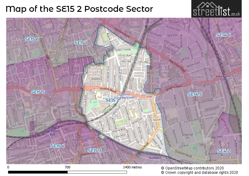
The SE15 2 Postcode shares a border with SE15 1 (LONDON ), SE4 2 (LONDON , CROFTON PARK , BROCKLEY ), SE14 5 (LONDON , BROCKLEY , NEW CROSS ), SE15 3 (LONDON ), SE15 4 (LONDON ) and SE15 5 (LONDON ).
The sector is within the post town of LONDON.
SE15 2 is a postcode sector within the SE15 postcode district which is within the SE South Eastern London postcode area.
The Royal Mail delivery office for the SE15 2 postal sector is the Peckham Sdelivery Office.
The area of the SE15 2 postcode sector is 0.38 square miles which is 0.99 square kilometres or 244.96 square acres.

Map of the SE15 2 Postcode Sector
Explore the SE15 2 postcode sector by using our free interactive map.
| S | E | 1 | 5 | - | 2 | X | X |
| S | E | 1 | 5 | Space | 2 | Letter | Letter |
Official List of Streets
Southwark (75 Streets)
Unofficial Streets or Alternative Spellings
Southwark
ALBERT WAY CLAYTON ROAD COPELAND ROAD GELDART ROAD GOLDSMITH ROAD KIMBERLEY AVENUE KINCAID ROAD NAYLOR ROAD PECKHAM HIGH STREET PENNETHORNE ROAD PORTBURY CLOSE REGAL ROW STUDHOLME STREETLewisham
BEACON GATE GELLATLY ROAD GODLEY CLOSE KENDER STREET KITTO ROAD POMEROY STREET WILD GOOSE DRIVE ASHDENE BEECHDENE BIDWELL STREET HATHWAY STREET LEO STREET LINDO STREET OAKDENE PINEDENE SENATE STREET WILLOWDENEWeather Forecast for SE15 2
Press Button to Show Forecast for Millwall F.C.
| Time Period | Icon | Description | Temperature | Rain Probability | Wind |
|---|---|---|---|---|---|
| 06:00 to 09:00 | Overcast | 7.0°C (feels like 6.0°C) | 10.00% | NNW 2 mph | |
| 09:00 to 12:00 | Overcast | 7.0°C (feels like 6.0°C) | 49.00% | W 4 mph | |
| 12:00 to 15:00 | Light rain | 8.0°C (feels like 7.0°C) | 52.00% | NW 7 mph | |
| 15:00 to 18:00 | Light rain shower (day) | 10.0°C (feels like 8.0°C) | 57.00% | N 11 mph | |
| 18:00 to 21:00 | Cloudy | 10.0°C (feels like 8.0°C) | 5.00% | NNE 9 mph | |
| 21:00 to 00:00 | Partly cloudy (night) | 8.0°C (feels like 6.0°C) | 1.00% | N 4 mph |
Press Button to Show Forecast for Millwall F.C.
| Time Period | Icon | Description | Temperature | Rain Probability | Wind |
|---|---|---|---|---|---|
| 00:00 to 03:00 | Cloudy | 7.0°C (feels like 5.0°C) | 5.00% | NNW 7 mph | |
| 03:00 to 06:00 | Cloudy | 6.0°C (feels like 4.0°C) | 5.00% | NNW 7 mph | |
| 06:00 to 09:00 | Overcast | 6.0°C (feels like 3.0°C) | 8.00% | NW 7 mph | |
| 09:00 to 12:00 | Overcast | 8.0°C (feels like 5.0°C) | 8.00% | NNW 11 mph | |
| 12:00 to 15:00 | Overcast | 9.0°C (feels like 7.0°C) | 8.00% | NNW 11 mph | |
| 15:00 to 18:00 | Cloudy | 10.0°C (feels like 8.0°C) | 6.00% | NNW 11 mph | |
| 18:00 to 21:00 | Cloudy | 9.0°C (feels like 7.0°C) | 6.00% | N 9 mph | |
| 21:00 to 00:00 | Partly cloudy (night) | 7.0°C (feels like 5.0°C) | 4.00% | NNW 7 mph |
Press Button to Show Forecast for Millwall F.C.
| Time Period | Icon | Description | Temperature | Rain Probability | Wind |
|---|---|---|---|---|---|
| 00:00 to 03:00 | Partly cloudy (night) | 5.0°C (feels like 3.0°C) | 2.00% | N 7 mph | |
| 03:00 to 06:00 | Partly cloudy (night) | 5.0°C (feels like 2.0°C) | 1.00% | NW 7 mph | |
| 06:00 to 09:00 | Partly cloudy (day) | 5.0°C (feels like 2.0°C) | 2.00% | NNW 7 mph | |
| 09:00 to 12:00 | Cloudy | 8.0°C (feels like 6.0°C) | 5.00% | NNW 9 mph | |
| 12:00 to 15:00 | Overcast | 10.0°C (feels like 8.0°C) | 9.00% | NNW 7 mph | |
| 15:00 to 18:00 | Cloudy | 11.0°C (feels like 10.0°C) | 9.00% | NNW 7 mph | |
| 18:00 to 21:00 | Cloudy | 10.0°C (feels like 9.0°C) | 18.00% | NNW 7 mph | |
| 21:00 to 00:00 | Cloudy | 8.0°C (feels like 7.0°C) | 6.00% | ENE 4 mph |
Press Button to Show Forecast for Millwall F.C.
| Time Period | Icon | Description | Temperature | Rain Probability | Wind |
|---|---|---|---|---|---|
| 00:00 to 03:00 | Partly cloudy (night) | 7.0°C (feels like 6.0°C) | 2.00% | E 4 mph | |
| 03:00 to 06:00 | Partly cloudy (night) | 6.0°C (feels like 5.0°C) | 3.00% | WNW 4 mph | |
| 06:00 to 09:00 | Cloudy | 6.0°C (feels like 5.0°C) | 5.00% | ESE 4 mph | |
| 09:00 to 12:00 | Cloudy | 9.0°C (feels like 8.0°C) | 5.00% | SE 4 mph | |
| 12:00 to 15:00 | Cloudy | 11.0°C (feels like 10.0°C) | 6.00% | SSE 7 mph | |
| 15:00 to 18:00 | Overcast | 12.0°C (feels like 11.0°C) | 14.00% | SSW 7 mph | |
| 18:00 to 21:00 | Cloudy | 12.0°C (feels like 10.0°C) | 10.00% | SE 7 mph | |
| 21:00 to 00:00 | Cloudy | 10.0°C (feels like 8.0°C) | 8.00% | SSE 7 mph |
Schools and Places of Education Within the SE15 2 Postcode Sector
Hollydale Primary School
Community school
Hollydale Road, London, , SE15 2AR
Head: Ms Reema Reid
Ofsted Rating: Good
Inspection: 2023-06-15 (313 days ago)
Website: Visit Hollydale Primary School Website
Phone: 02076392562
Number of Pupils: 157
John Donne Primary School
Academy converter
Woods Road, London, , SE15 2SW
Head: Miss Jo Rooney
Ofsted Rating: Good
Inspection: 2023-11-30 (145 days ago)
Website: Visit John Donne Primary School Website
Phone: 02076390594
Number of Pupils: 406
Nell Gwynn Nursery School
Local authority nursery school
Meeting House Lane, London, , SE15 2TT
Head: Mr Gregory Doey
Ofsted Rating: Good
Inspection: 2023-05-11 (348 days ago)
Website: Visit Nell Gwynn Nursery School Website
Phone: 02072528265
Number of Pupils: 95
The St Thomas the Apostle College
Voluntary aided school
Hollydale Road, London, , SE15 2EB
Head: Mr Eamon Connolly
Ofsted Rating: Outstanding
Inspection: 2018-11-21 (1980 days ago)
Website: Visit The St Thomas the Apostle College Website
Phone: 02076390106
Number of Pupils: 1083
House Prices in the SE15 2 Postcode Sector
| Type of Property | 2018 Average | 2018 Sales | 2017 Average | 2017 Sales | 2016 Average | 2016 Sales | 2015 Average | 2015 Sales |
|---|---|---|---|---|---|---|---|---|
| Detached | £625,000 | 1 | £0 | 0 | £995,000 | 3 | £1,280,000 | 1 |
| Semi-Detached | £673,200 | 5 | £855,000 | 1 | £925,000 | 2 | £245,000 | 1 |
| Terraced | £651,346 | 39 | £789,665 | 33 | £666,602 | 45 | £635,480 | 69 |
| Flats | £409,481 | 66 | £466,936 | 163 | £397,071 | 123 | £353,532 | 104 |
Important Postcodes SE15 2 in the Postcode Sector
SE15 2AR is the postcode for Hollydale Primary School, Hollydale Road
SE15 2BQ is the postcode for Greenhive House, 50 Brayards Road
SE15 2HG is the postcode for 1, Lugard Road, and 1 LUGARD ROAD, LONDON
SE15 2HP is the postcode for 132 Queens Road, 134 Queens Road, and 132 QUEENS ROAD, LONDON
SE15 2SW is the postcode for John Donne Primary School, Woods Road
| The SE15 2 Sector is within these Local Authorities |
|
|---|---|
| The SE15 2 Sector is within these Counties |
|
| The SE15 2 Sector is within these Water Company Areas |
|