The SE20 7 postcode sector is within the county of Greater London.
Did you know? According to the 2021 Census, the SE20 7 postcode sector is home to a bustling 12,194 residents!
Given that each sector allows for 400 unique postcode combinations. Letters C, I, K, M, O and V are not allowed in the last two letters of a postcode. With 226 postcodes already in use, this leaves 174 units available.
The largest settlements in the SE20 7 postal code are PENGE and BECKENHAM .
The SE20 7 Postcode shares a border with SE20 8 (PENGE ), SE26 5 (LONDON , SYDENHAM , LOWER SYDENHAM ), BR3 4 (BECKENHAM ), SE25 4 (SOUTH NORWOOD ), SE26 6 (LONDON , SYDENHAM ) and BR3 1 (BECKENHAM , BELLINGHAM ).
The sector is within the post town of LONDON.
SE20 7 is a postcode sector within the SE20 postcode district which is within the SE South Eastern London postcode area.
The Royal Mail delivery office for the SE20 7 postal sector is the Anerley Sdelivery Office.
The area of the SE20 7 postcode sector is 0.53 square miles which is 1.37 square kilometres or 338.21 square acres.

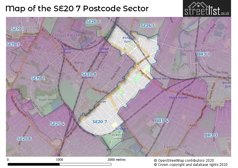
Map of the SE20 7 Postcode Sector
Explore the SE20 7 postcode sector by using our free interactive map.
| S | E | 2 | 0 | - | 7 | X | X |
| S | E | 2 | 0 | Space | 7 | Letter | Letter |
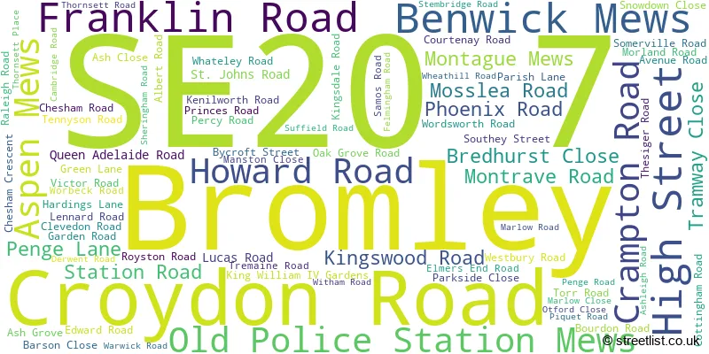
Official List of Streets
Bromley (80 Streets)
Unofficial Streets or Alternative Spellings
Bromley
ALEXANDRA ROAD ANERLEY ROAD AVINGTON GROVE BEECHES CLOSE CATOR ROAD EVELINA ROAD GENOA ROAD HAYSLEIGH GARDENS KENT HOUSE ROAD LINDEN GROVE MAITLAND ROAD MAPLE ROAD MELVIN ROAD NEWLANDS PARK OAKFIELD ROAD PADUA ROAD SELBY ROAD STODART ROAD VENNER ROADBECKENHAM
BECKENHAM ROAD KINGS HALL ROAD PELHAM ROAD RAVENSCROFT ROADCroydon
HARRINGTON ROAD BRYON CLOSE GRACE MEWS IMPACT COURT LONDON BRIDGE TO WINDMILL BRIDGE JUNCTION SOMER ROAD TRINITY MEWS WHEATHILL HOUSEWeather Forecast for SE20 7
Press Button to Show Forecast for Crystal Palace National Sports Centre
| Time Period | Icon | Description | Temperature | Rain Probability | Wind |
|---|---|---|---|---|---|
| 00:00 to 03:00 | Cloudy | 6.0°C (feels like 4.0°C) | 4.00% | S 4 mph | |
| 03:00 to 06:00 | Cloudy | 5.0°C (feels like 3.0°C) | 5.00% | SSW 7 mph | |
| 06:00 to 09:00 | Cloudy | 6.0°C (feels like 4.0°C) | 11.00% | SW 7 mph | |
| 09:00 to 12:00 | Partly cloudy (day) | 9.0°C (feels like 7.0°C) | 5.00% | W 9 mph | |
| 12:00 to 15:00 | Cloudy | 10.0°C (feels like 8.0°C) | 14.00% | W 11 mph | |
| 15:00 to 18:00 | Light rain | 10.0°C (feels like 8.0°C) | 54.00% | W 9 mph | |
| 18:00 to 21:00 | Light rain | 9.0°C (feels like 7.0°C) | 52.00% | NNW 7 mph | |
| 21:00 to 00:00 | Cloudy | 7.0°C (feels like 5.0°C) | 12.00% | ENE 7 mph |
Press Button to Show Forecast for Crystal Palace National Sports Centre
| Time Period | Icon | Description | Temperature | Rain Probability | Wind |
|---|---|---|---|---|---|
| 00:00 to 03:00 | Cloudy | 6.0°C (feels like 4.0°C) | 5.00% | ENE 7 mph | |
| 03:00 to 06:00 | Cloudy | 5.0°C (feels like 3.0°C) | 5.00% | NE 7 mph | |
| 06:00 to 09:00 | Cloudy | 5.0°C (feels like 2.0°C) | 5.00% | NE 7 mph | |
| 09:00 to 12:00 | Cloudy | 7.0°C (feels like 5.0°C) | 5.00% | ENE 7 mph | |
| 12:00 to 15:00 | Cloudy | 10.0°C (feels like 9.0°C) | 11.00% | ENE 7 mph | |
| 15:00 to 18:00 | Cloudy | 11.0°C (feels like 9.0°C) | 13.00% | ENE 7 mph | |
| 18:00 to 21:00 | Cloudy | 10.0°C (feels like 8.0°C) | 13.00% | E 7 mph | |
| 21:00 to 00:00 | Cloudy | 7.0°C (feels like 5.0°C) | 11.00% | E 7 mph |
Press Button to Show Forecast for Crystal Palace National Sports Centre
| Time Period | Icon | Description | Temperature | Rain Probability | Wind |
|---|---|---|---|---|---|
| 00:00 to 03:00 | Cloudy | 5.0°C (feels like 3.0°C) | 17.00% | ENE 7 mph | |
| 03:00 to 06:00 | Cloudy | 5.0°C (feels like 3.0°C) | 18.00% | NE 7 mph | |
| 06:00 to 09:00 | Cloudy | 5.0°C (feels like 3.0°C) | 17.00% | ENE 7 mph | |
| 09:00 to 12:00 | Overcast | 9.0°C (feels like 7.0°C) | 18.00% | ENE 9 mph | |
| 12:00 to 15:00 | Cloudy | 12.0°C (feels like 9.0°C) | 14.00% | E 9 mph | |
| 15:00 to 18:00 | Light rain | 12.0°C (feels like 10.0°C) | 51.00% | E 11 mph | |
| 18:00 to 21:00 | Light rain | 11.0°C (feels like 9.0°C) | 54.00% | ENE 9 mph | |
| 21:00 to 00:00 | Light rain | 9.0°C (feels like 7.0°C) | 54.00% | ENE 11 mph |
Press Button to Show Forecast for Crystal Palace National Sports Centre
| Time Period | Icon | Description | Temperature | Rain Probability | Wind |
|---|---|---|---|---|---|
| 00:00 to 03:00 | Heavy rain | 9.0°C (feels like 7.0°C) | 75.00% | NE 9 mph | |
| 03:00 to 06:00 | Light rain | 10.0°C (feels like 8.0°C) | 56.00% | ESE 9 mph | |
| 06:00 to 09:00 | Light rain | 9.0°C (feels like 8.0°C) | 51.00% | SE 7 mph | |
| 09:00 to 12:00 | Light rain shower (day) | 10.0°C (feels like 8.0°C) | 46.00% | SSE 9 mph | |
| 12:00 to 15:00 | Heavy rain shower (day) | 12.0°C (feels like 10.0°C) | 61.00% | S 9 mph | |
| 15:00 to 18:00 | Light rain shower (day) | 13.0°C (feels like 11.0°C) | 39.00% | SSW 11 mph | |
| 18:00 to 21:00 | Light rain shower (day) | 12.0°C (feels like 10.0°C) | 34.00% | SW 11 mph | |
| 21:00 to 00:00 | Cloudy | 10.0°C (feels like 8.0°C) | 9.00% | SSW 7 mph |
Schools and Places of Education Within the SE20 7 Postcode Sector
Harris Primary Academy Kent House
Academy sponsor led
High Street, London, , SE20 7QR
Head: Ms Rachel Bowern
Ofsted Rating: Outstanding
Inspection: 2022-05-05 (721 days ago)
Website: Visit Harris Primary Academy Kent House Website
Phone: 02084027178
Number of Pupils: 396
Stewart Fleming Primary School
Academy converter
Witham Road, London, , SE20 7YB
Head: Mrs Rachel Lincoln
Ofsted Rating: Outstanding
Inspection: 2023-04-20 (371 days ago)
Website: Visit Stewart Fleming Primary School Website
Phone: 02087781043
Number of Pupils: 496
House Prices in the SE20 7 Postcode Sector
| Type of Property | 2018 Average | 2018 Sales | 2017 Average | 2017 Sales | 2016 Average | 2016 Sales | 2015 Average | 2015 Sales |
|---|---|---|---|---|---|---|---|---|
| Detached | £328,000 | 2 | £730,000 | 3 | £1,000,000 | 1 | £661,500 | 2 |
| Semi-Detached | £620,676 | 21 | £587,910 | 15 | £618,108 | 19 | £493,786 | 21 |
| Terraced | £497,523 | 57 | £528,522 | 69 | £540,718 | 58 | £482,078 | 101 |
| Flats | £306,061 | 84 | £317,618 | 113 | £301,557 | 98 | £266,936 | 115 |
Important Postcodes SE20 7 in the Postcode Sector
SE20 7JX is the postcode for Penge Library, 46 Green Lane
SE20 7QR is the postcode for DINING HALL, Harris Primary Kent House, High Street, and Harris Primary Kent House, High Street
SE20 7YB is the postcode for EYFS, Stewart Fleming Primary School, Witham Road, Stewart Fleming Primary School, Witham Road, and YEAR 5/6 BLOCK, Stewart Fleming Primary School, Witham Road
| The SE20 7 Sector is within these Local Authorities |
|
|---|---|
| The SE20 7 Sector is within these Counties |
|
| The SE20 7 Sector is within these Water Company Areas |
|