The SG10 6 postcode sector is within the county of Hertfordshire.
Did you know? According to the 2021 Census, the SG10 6 postcode sector is home to a bustling 2,200 residents!
Given that each sector allows for 400 unique postcode combinations. Letters C, I, K, M, O and V are not allowed in the last two letters of a postcode. With 110 postcodes already in use, this leaves 290 units available.
The SG10 6 postal code covers the settlement of MUCH HADHAM.
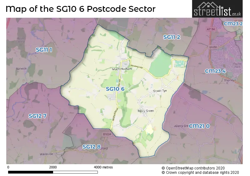
The SG10 6 Postcode shares a border with SG11 1 (Puckeridge, Standon, High Cross), SG11 2 (Little Hadham, Braughing, Albury), SG12 7 (WARE, Wareside, Thundridge), CM21 0 (SAWBRIDGEWORTH, High Wych, Allens Green), CM23 4 (BISHOP'S STORTFORD, Thorley, Spellbrook) and SG12 8 (Stanstead Abbotts, Hunsdon, Widford).
The sector is within the post town of MUCH HADHAM.
SG10 6 is a postcode sector within the SG10 postcode district which is within the SG Stevenage postcode area.
The Royal Mail delivery office for the SG10 6 postal sector is the Ware Delivery Office.
The area of the SG10 6 postcode sector is 7.38 square miles which is 19.13 square kilometres or 4,725.98 square acres.

Map of the SG10 6 Postcode Sector
Explore the SG10 6 postcode sector by using our free interactive map.
| S | G | 1 | 0 | - | 6 | X | X |
| S | G | 1 | 0 | Space | 6 | Letter | Letter |
Official List of Streets
MUCH HADHAM (30 Streets)
Unofficial Streets or Alternative Spellings
Weather Forecast for SG10 6
Press Button to Show Forecast for Dane End
| Time Period | Icon | Description | Temperature | Rain Probability | Wind |
|---|---|---|---|---|---|
| 00:00 to 03:00 | Clear night | 4.0°C (feels like 0.0°C) | 0.00% | NNW 9 mph | |
| 03:00 to 06:00 | Clear night | 3.0°C (feels like -1.0°C) | 0.00% | NNW 11 mph | |
| 06:00 to 09:00 | Cloudy | 4.0°C (feels like 0.0°C) | 3.00% | NNW 11 mph | |
| 09:00 to 12:00 | Cloudy | 7.0°C (feels like 4.0°C) | 3.00% | N 13 mph | |
| 12:00 to 15:00 | Cloudy | 9.0°C (feels like 6.0°C) | 5.00% | N 13 mph | |
| 15:00 to 18:00 | Cloudy | 10.0°C (feels like 7.0°C) | 5.00% | N 13 mph | |
| 18:00 to 21:00 | Partly cloudy (day) | 8.0°C (feels like 6.0°C) | 1.00% | NNE 9 mph | |
| 21:00 to 00:00 | Partly cloudy (night) | 5.0°C (feels like 3.0°C) | 1.00% | NNE 7 mph |
Press Button to Show Forecast for Dane End
| Time Period | Icon | Description | Temperature | Rain Probability | Wind |
|---|---|---|---|---|---|
| 00:00 to 03:00 | Cloudy | 4.0°C (feels like 2.0°C) | 4.00% | NNW 7 mph | |
| 03:00 to 06:00 | Cloudy | 4.0°C (feels like 1.0°C) | 5.00% | NNW 7 mph | |
| 06:00 to 09:00 | Overcast | 5.0°C (feels like 2.0°C) | 9.00% | NNW 7 mph | |
| 09:00 to 12:00 | Overcast | 7.0°C (feels like 4.0°C) | 10.00% | N 11 mph | |
| 12:00 to 15:00 | Overcast | 9.0°C (feels like 7.0°C) | 9.00% | NNE 11 mph | |
| 15:00 to 18:00 | Cloudy | 10.0°C (feels like 7.0°C) | 5.00% | NNE 11 mph | |
| 18:00 to 21:00 | Partly cloudy (day) | 9.0°C (feels like 6.0°C) | 2.00% | NNE 11 mph | |
| 21:00 to 00:00 | Clear night | 5.0°C (feels like 3.0°C) | 4.00% | NNE 7 mph |
Press Button to Show Forecast for Dane End
| Time Period | Icon | Description | Temperature | Rain Probability | Wind |
|---|---|---|---|---|---|
| 00:00 to 03:00 | Clear night | 4.0°C (feels like 1.0°C) | 3.00% | NNE 7 mph | |
| 03:00 to 06:00 | Clear night | 3.0°C (feels like 0.0°C) | 3.00% | N 7 mph | |
| 06:00 to 09:00 | Partly cloudy (day) | 4.0°C (feels like 1.0°C) | 3.00% | N 7 mph | |
| 09:00 to 12:00 | Cloudy | 8.0°C (feels like 6.0°C) | 7.00% | N 7 mph | |
| 12:00 to 15:00 | Overcast | 9.0°C (feels like 7.0°C) | 14.00% | NNW 7 mph | |
| 15:00 to 18:00 | Overcast | 9.0°C (feels like 7.0°C) | 18.00% | NNW 7 mph | |
| 18:00 to 21:00 | Cloudy | 8.0°C (feels like 6.0°C) | 17.00% | NNW 7 mph | |
| 21:00 to 00:00 | Cloudy | 6.0°C (feels like 4.0°C) | 14.00% | NNW 4 mph |
Press Button to Show Forecast for Dane End
| Time Period | Icon | Description | Temperature | Rain Probability | Wind |
|---|---|---|---|---|---|
| 00:00 to 03:00 | Cloudy | 5.0°C (feels like 3.0°C) | 10.00% | NNE 4 mph | |
| 03:00 to 06:00 | Cloudy | 5.0°C (feels like 3.0°C) | 14.00% | NNW 4 mph | |
| 06:00 to 09:00 | Cloudy | 5.0°C (feels like 3.0°C) | 12.00% | NNW 7 mph | |
| 09:00 to 12:00 | Cloudy | 8.0°C (feels like 6.0°C) | 9.00% | NNE 9 mph | |
| 12:00 to 15:00 | Overcast | 10.0°C (feels like 8.0°C) | 17.00% | N 9 mph | |
| 15:00 to 18:00 | Overcast | 10.0°C (feels like 8.0°C) | 17.00% | N 9 mph | |
| 18:00 to 21:00 | Partly cloudy (day) | 9.0°C (feels like 7.0°C) | 9.00% | NNE 9 mph | |
| 21:00 to 00:00 | Clear night | 6.0°C (feels like 4.0°C) | 5.00% | NNE 7 mph |
Schools and Places of Education Within the SG10 6 Postcode Sector
St Andrew's CE Primary School and Nursery
Voluntary aided school
Tower Hill, Much Hadham, Hertfordshire, SG10 6DL
Head: Mrs Caroline Dimond
Ofsted Rating: Good
Inspection: 2023-07-19 (276 days ago)
Website: Visit St Andrew's CE Primary School and Nursery Website
Phone: 01279842626
Number of Pupils: 215
St Elizabeth's Centre
Special post 16 institution
Perry Green, Hertfordshire, Hertfordshire, SG10 6EW
Head: Mrs Teresa Glynn
Ofsted Rating: Good
Inspection: 2022-04-29 (722 days ago)
Website: Visit St Elizabeth's Centre Website
Phone: 01279844419
Number of Pupils: 0
St Elizabeth's School
Non-maintained special school
South End, Much Hadham, Hertfordshire, SG10 6EW
Head: Mrs Lisa Tooley
Ofsted Rating: Good
Inspection: 2023-10-11 (192 days ago)
Website: Visit St Elizabeth's School Website
Phone: 01279844270
Number of Pupils: 37
House Prices in the SG10 6 Postcode Sector
| Type of Property | 2018 Average | 2018 Sales | 2017 Average | 2017 Sales | 2016 Average | 2016 Sales | 2015 Average | 2015 Sales |
|---|---|---|---|---|---|---|---|---|
| Detached | £1,005,971 | 17 | £1,115,000 | 10 | £1,167,000 | 15 | £950,342 | 19 |
| Semi-Detached | £636,500 | 10 | £582,187 | 8 | £545,000 | 3 | £665,000 | 4 |
| Terraced | £600,222 | 9 | £580,086 | 9 | £327,999 | 8 | £408,210 | 10 |
| Flats | £0 | 0 | £272,667 | 3 | £0 | 0 | £226,000 | 1 |
Important Postcodes SG10 6 in the Postcode Sector
SG10 6DL is the postcode for LOWER SCHOOL, St Andrew's C of E Primary and Nursery School, Tower Hill, and MAIN BLOCK, St Andrew's C of E Primary and Nursery School, Tower Hill
SG10 6FB is the postcode for Bishops Stortford High School, Jobbers Wood Sports Pavilion, Great Hadham Road
| The SG10 6 Sector is within these Local Authorities |
|
|---|---|
| The SG10 6 Sector is within these Counties |
|
| The SG10 6 Sector is within these Water Company Areas |
|