The SG11 1 postcode sector is within the county of Hertfordshire.
Did you know? According to the 2021 Census, the SG11 1 postcode sector is home to a bustling 5,756 residents!
Given that each sector allows for 400 unique postcode combinations. Letters C, I, K, M, O and V are not allowed in the last two letters of a postcode. With 207 postcodes already in use, this leaves 193 units available.
The largest settlement in the SG11 1 postal code is Puckeridge followed by Standon, and High Cross.
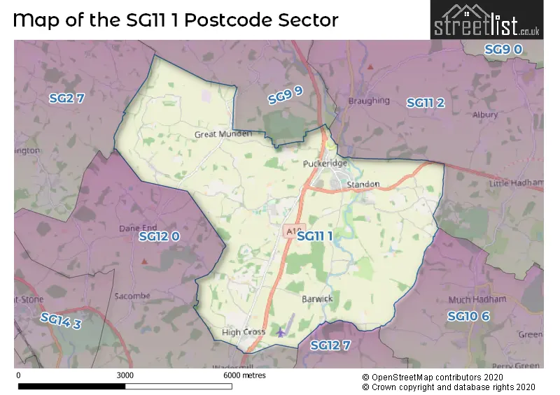
The SG11 1 Postcode shares a border with SG2 7 (STEVENAGE, Walkern, Benington), SG9 9 (BUNTINGFORD, Cottered, Westmill), SG10 6 (MUCH HADHAM), SG11 2 (Little Hadham, Braughing, Albury), SG12 0 (WARE, Dane End, Thundridge) and SG12 7 (WARE, Wareside, Thundridge).
The sector is within the post town of WARE.
SG11 1 is a postcode sector within the SG11 postcode district which is within the SG Stevenage postcode area.
The Royal Mail delivery office for the SG11 1 postal sector is the Ware Delivery Office.
The area of the SG11 1 postcode sector is 15.93 square miles which is 41.25 square kilometres or 10,193.24 square acres.
Waterways within the SG11 1 postcode sector include the River Rib, The Bourne.

Map of the SG11 1 Postcode Sector
Explore the SG11 1 postcode sector by using our free interactive map.
| S | G | 1 | 1 | - | 1 | X | X |
| S | G | 1 | 1 | Space | 1 | Letter | Letter |
Official List of Streets
WARE (3 Streets)
Standon (32 Streets)
Puckeridge (34 Streets)
High Cross (9 Streets)
Old Hall Green (3 Streets)
Colliers End (4 Streets)
Haultwick (1 Streets)
Great Munden (1 Streets)
Unofficial Streets or Alternative Spellings
MUCH HADHAM
BROMLEY LANE KETTLE GREEN LANE ARTHUR MARTIN LEAKE WAY BARWICK LANE CAMBRIDGE COURT CANNONS COURT CHAPMANS YARD DANE END ROAD DARK LANE DOWSETTS LANE OVERBRIDGE ERMINE STREET FROGHALL LANE GIFFORDS LANE GORE LANE GRAFTON PLACE GREEN LEYS COTTAGES HALF ACRES HAMMERSFIELD CLOSE HILLTOP COTTAGES HOME FARM COURT HORSE CROSS HUNTSMANS CLOSE JACOBS LADDER LANGTONS LANE LOVERS WALK LOWGATE LANE MENTLEY LANE MORLEY LANE MUNDEN ROAD NORTH DRIVE BRIDGE PUCKERIDGE BY-PASS RIGERY LANE SAFFRON MEADOWS ST MARYS ROAD STANDON COURT STOCKALLS LANE STORTFORD LANE THE GRANGE THE STREET UPPER BACCHUS VINTAGE COURT WENTWORTH COTTAGESLittle Hadham
STANDON ROADStandon
SARGENTSBraughing
STATION ROADThundridge
CAMBRIDGE ROAD COLD CHRISTMAS LANEDane End
MILL LANEWeather Forecast for SG11 1
Press Button to Show Forecast for Dane End
| Time Period | Icon | Description | Temperature | Rain Probability | Wind |
|---|---|---|---|---|---|
| 00:00 to 03:00 | Overcast | 8.0°C (feels like 5.0°C) | 58.00% | W 13 mph | |
| 03:00 to 06:00 | Overcast | 9.0°C (feels like 6.0°C) | 47.00% | W 13 mph | |
| 06:00 to 09:00 | Overcast | 9.0°C (feels like 6.0°C) | 16.00% | WNW 13 mph | |
| 09:00 to 12:00 | Cloudy | 10.0°C (feels like 7.0°C) | 33.00% | NW 16 mph | |
| 12:00 to 15:00 | Overcast | 11.0°C (feels like 8.0°C) | 19.00% | NW 16 mph | |
| 15:00 to 18:00 | Cloudy | 10.0°C (feels like 7.0°C) | 30.00% | N 13 mph | |
| 18:00 to 21:00 | Cloudy | 8.0°C (feels like 5.0°C) | 7.00% | NNE 11 mph | |
| 21:00 to 00:00 | Clear night | 6.0°C (feels like 2.0°C) | 3.00% | N 9 mph |
Press Button to Show Forecast for Dane End
| Time Period | Icon | Description | Temperature | Rain Probability | Wind |
|---|---|---|---|---|---|
| 00:00 to 03:00 | Clear night | 4.0°C (feels like 1.0°C) | 1.00% | NNW 9 mph | |
| 03:00 to 06:00 | Cloudy | 4.0°C (feels like 0.0°C) | 4.00% | NNW 11 mph | |
| 06:00 to 09:00 | Overcast | 4.0°C (feels like 0.0°C) | 8.00% | NNW 11 mph | |
| 09:00 to 12:00 | Overcast | 7.0°C (feels like 3.0°C) | 8.00% | N 13 mph | |
| 12:00 to 15:00 | Overcast | 9.0°C (feels like 6.0°C) | 9.00% | N 11 mph | |
| 15:00 to 18:00 | Overcast | 9.0°C (feels like 7.0°C) | 8.00% | N 11 mph | |
| 18:00 to 21:00 | Overcast | 8.0°C (feels like 6.0°C) | 8.00% | NNE 9 mph | |
| 21:00 to 00:00 | Partly cloudy (night) | 6.0°C (feels like 4.0°C) | 2.00% | NNE 7 mph |
Press Button to Show Forecast for Dane End
| Time Period | Icon | Description | Temperature | Rain Probability | Wind |
|---|---|---|---|---|---|
| 00:00 to 03:00 | Partly cloudy (night) | 4.0°C (feels like 3.0°C) | 2.00% | NNW 4 mph | |
| 03:00 to 06:00 | Overcast | 4.0°C (feels like 2.0°C) | 8.00% | NNW 4 mph | |
| 06:00 to 09:00 | Overcast | 5.0°C (feels like 3.0°C) | 10.00% | N 7 mph | |
| 09:00 to 12:00 | Overcast | 7.0°C (feels like 5.0°C) | 11.00% | N 9 mph | |
| 12:00 to 15:00 | Overcast | 9.0°C (feels like 7.0°C) | 12.00% | NNE 11 mph | |
| 15:00 to 18:00 | Overcast | 10.0°C (feels like 8.0°C) | 12.00% | NNE 11 mph | |
| 18:00 to 21:00 | Cloudy | 9.0°C (feels like 6.0°C) | 7.00% | NNE 11 mph | |
| 21:00 to 00:00 | Clear night | 6.0°C (feels like 3.0°C) | 4.00% | NNE 9 mph |
Press Button to Show Forecast for Dane End
| Time Period | Icon | Description | Temperature | Rain Probability | Wind |
|---|---|---|---|---|---|
| 00:00 to 03:00 | Partly cloudy (night) | 5.0°C (feels like 2.0°C) | 4.00% | NNE 7 mph | |
| 03:00 to 06:00 | Partly cloudy (night) | 4.0°C (feels like 2.0°C) | 3.00% | N 7 mph | |
| 06:00 to 09:00 | Partly cloudy (day) | 5.0°C (feels like 2.0°C) | 3.00% | N 7 mph | |
| 09:00 to 12:00 | Cloudy | 9.0°C (feels like 6.0°C) | 6.00% | NNE 11 mph | |
| 12:00 to 15:00 | Cloudy | 10.0°C (feels like 8.0°C) | 7.00% | NNE 11 mph | |
| 15:00 to 18:00 | Cloudy | 10.0°C (feels like 8.0°C) | 10.00% | NNE 11 mph | |
| 18:00 to 21:00 | Cloudy | 9.0°C (feels like 6.0°C) | 6.00% | NE 9 mph | |
| 21:00 to 00:00 | Partly cloudy (night) | 6.0°C (feels like 3.0°C) | 4.00% | NNE 7 mph |
Schools and Places of Education Within the SG11 1 Postcode Sector
Puller Memorial, Church of England, Voluntary Aided Primary School
Voluntary aided school
High Cross, Ware, Hertfordshire, SG11 1AZ
Head: Mrs Samantha Squires
Ofsted Rating: Good
Inspection: 2022-05-25 (695 days ago)
Website: Visit Puller Memorial, Church of England, Voluntary Aided Primary School Website
Phone: 01920463178
Number of Pupils: 63
Ralph Sadleir School
Academy converter
Station Road, Ware, Hertfordshire, SG11 1TF
Head: Mrs Kerry Scripps
Ofsted Rating: Good
Inspection: 2022-10-19 (548 days ago)
Website: Visit Ralph Sadleir School Website
Phone: 01920821042
Number of Pupils: 348
Roger De Clare First CofE School
Voluntary controlled school
Station Road, Ware, Hertfordshire, SG11 1TF
Head: Mrs Laura Woods
Ofsted Rating: Requires improvement
Inspection: 2021-09-22 (940 days ago)
Website: Visit Roger De Clare First CofE School Website
Phone: 01920821363
Number of Pupils: 280
St Thomas of Canterbury Catholic Primary School
Academy converter
High Street, Ware, Hertfordshire, SG11 1RZ
Head: Mrs Michelle Keating
Ofsted Rating: Good
Inspection: 2023-02-22 (422 days ago)
Website: Visit St Thomas of Canterbury Catholic Primary School Website
Phone: 01920821450
Number of Pupils: 118
House Prices in the SG11 1 Postcode Sector
| Type of Property | 2018 Average | 2018 Sales | 2017 Average | 2017 Sales | 2016 Average | 2016 Sales | 2015 Average | 2015 Sales |
|---|---|---|---|---|---|---|---|---|
| Detached | £711,679 | 28 | £661,193 | 37 | £704,143 | 42 | £503,090 | 24 |
| Semi-Detached | £449,750 | 10 | £389,603 | 28 | £384,479 | 30 | £362,194 | 28 |
| Terraced | £329,600 | 25 | £332,413 | 23 | £326,196 | 24 | £319,197 | 38 |
| Flats | £235,500 | 12 | £216,119 | 8 | £231,466 | 15 | £218,409 | 11 |
Important Postcodes SG11 1 in the Postcode Sector
SG11 1RZ is the postcode for St Thomas of Canterbury Catholic Primary School, Cambridge Road
SG11 1TF is the postcode for Ralph Sadler School, Station Road, Roger de Clare School, Station Road, Puckeridge, Ralph Sadleir School, Station Road, MAIN BLOCK, Roger de Clare CofE VC First & Nursery School, Station Road, The Surgery, Station Road, RALPH SADLIER MIDDLE SCHOOL, STATION ROAD, PUCKERIDGE, and Roger de Clare School, Station Road
| The SG11 1 Sector is within these Local Authorities |
|
|---|---|
| The SG11 1 Sector is within these Counties |
|
| The SG11 1 Sector is within these Water Company Areas |
|