The SG12 0 postcode sector is within the county of Hertfordshire.
Did you know? According to the 2021 Census, the SG12 0 postcode sector is home to a bustling 9,097 residents!
Given that each sector allows for 400 unique postcode combinations. Letters C, I, K, M, O and V are not allowed in the last two letters of a postcode. With 268 postcodes already in use, this leaves 132 units available.
The largest settlement in the SG12 0 postal code is WARE followed by Dane End, and Thundridge.
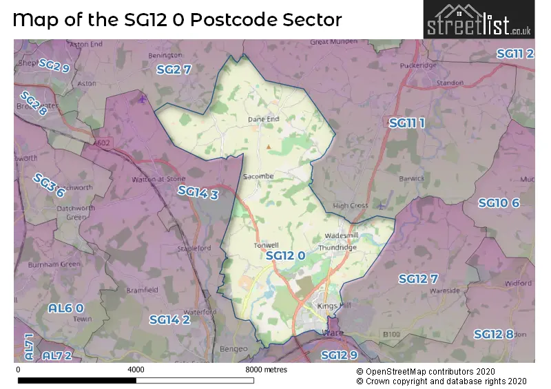
The SG12 0 Postcode shares a border with SG13 7 (HERTFORD, Hertford Heath, Hailey), SG2 7 (STEVENAGE, Walkern, Benington), SG11 1 (Puckeridge, Standon, High Cross), SG12 7 (WARE, Wareside, Thundridge), SG12 9 (WARE, Great Amwell) and SG14 3 (HERTFORD, Watton At Stone, Stapleford).
The sector is within the post town of WARE.
SG12 0 is a postcode sector within the SG12 postcode district which is within the SG Stevenage postcode area.
The Royal Mail delivery office for the SG12 0 postal sector is the Ware Delivery Office.
The area of the SG12 0 postcode sector is 13.99 square miles which is 36.23 square kilometres or 8,953.58 square acres.
Waterways within the SG12 0 postcode sector include the New River, River Lea Navigation, Lee Navigation, Sacombe Park Tributary, River Rib, The Bourne, River Lea, Ware Lock.

Map of the SG12 0 Postcode Sector
Explore the SG12 0 postcode sector by using our free interactive map.
| S | G | 1 | 2 | - | 0 | X | X |
| S | G | 1 | 2 | Space | 0 | Letter | Letter |
Official List of Streets
WARE (71 Streets)
Wadesmill (5 Streets)
Tonwell (6 Streets)
Thundridge (10 Streets)
Dane End (18 Streets)
Chapmore End (6 Streets)
Sacombe (4 Streets)
Westmill (1 Streets)
Unofficial Streets or Alternative Spellings
WARE
BALDOCK STREET BURYFIELD WAY CHAPMORE END CHAPPELL COURT COLD CHRISTMAS LANE BRIDGE COTTON LANE DANE END BRIDGE ELEAONRS CLOSE GENTLEMENS FIELD GLAXO FOOTBRIDGE GRAVEL PIT HAUL ROAD GYPSY LANE HARRISS LANE KINGSMEAD VIADUCT LANGTONS LANE LOVERS WALK LOWGATE LANE MARSHALLS LANE MILL CLOSE PAYNES HALL OR WESTMILL ROUNDABOUT POLES PARK QUINCEY ROAD RENDLESHAM CLOSE RICKNEYS LANE SACOMBE ROAD STONY HILLS THE AVENUE THE DELL THE LAMMAS ROAD THUNDERCOURT TONWELL BYPASS ROAD VALLEY CLOSE WARE DRIVE WESTMILL BYPASS WESTMILL INTERCHANGE WHEMPSTEAD LANEHERTFORD
WADESMILL ROAD WARE PARK ROADBenington
HIGH ELMS LANE WHEMPSTEAD ROADWaterford
SACOMBE ROADWatton At Stone
MILL LANEWeather Forecast for SG12 0
Press Button to Show Forecast for Ware
| Time Period | Icon | Description | Temperature | Rain Probability | Wind |
|---|---|---|---|---|---|
| 15:00 to 18:00 | Cloudy | 8.0°C (feels like 6.0°C) | 13.00% | N 9 mph | |
| 18:00 to 21:00 | Partly cloudy (day) | 8.0°C (feels like 6.0°C) | 7.00% | N 7 mph | |
| 21:00 to 00:00 | Cloudy | 6.0°C (feels like 5.0°C) | 4.00% | ESE 2 mph |
Press Button to Show Forecast for Ware
| Time Period | Icon | Description | Temperature | Rain Probability | Wind |
|---|---|---|---|---|---|
| 00:00 to 03:00 | Cloudy | 5.0°C (feels like 4.0°C) | 5.00% | S 4 mph | |
| 03:00 to 06:00 | Cloudy | 5.0°C (feels like 4.0°C) | 5.00% | SSW 4 mph | |
| 06:00 to 09:00 | Light rain shower (day) | 6.0°C (feels like 4.0°C) | 36.00% | WSW 7 mph | |
| 09:00 to 12:00 | Cloudy | 9.0°C (feels like 7.0°C) | 7.00% | W 7 mph | |
| 12:00 to 15:00 | Cloudy | 10.0°C (feels like 8.0°C) | 51.00% | WNW 9 mph | |
| 15:00 to 18:00 | Light rain | 9.0°C (feels like 7.0°C) | 52.00% | NNW 11 mph | |
| 18:00 to 21:00 | Cloudy | 8.0°C (feels like 6.0°C) | 7.00% | NNE 7 mph | |
| 21:00 to 00:00 | Cloudy | 6.0°C (feels like 5.0°C) | 7.00% | NE 4 mph |
Press Button to Show Forecast for Ware
| Time Period | Icon | Description | Temperature | Rain Probability | Wind |
|---|---|---|---|---|---|
| 00:00 to 03:00 | Cloudy | 5.0°C (feels like 3.0°C) | 3.00% | NE 4 mph | |
| 03:00 to 06:00 | Partly cloudy (night) | 3.0°C (feels like 1.0°C) | 1.00% | NE 4 mph | |
| 06:00 to 09:00 | Sunny day | 3.0°C (feels like 1.0°C) | 1.00% | NNE 7 mph | |
| 09:00 to 12:00 | Partly cloudy (day) | 8.0°C (feels like 6.0°C) | 1.00% | NE 7 mph | |
| 12:00 to 15:00 | Cloudy | 10.0°C (feels like 9.0°C) | 9.00% | ENE 4 mph | |
| 15:00 to 18:00 | Overcast | 11.0°C (feels like 10.0°C) | 12.00% | NE 4 mph | |
| 18:00 to 21:00 | Cloudy | 10.0°C (feels like 8.0°C) | 10.00% | ENE 7 mph | |
| 21:00 to 00:00 | Cloudy | 6.0°C (feels like 4.0°C) | 9.00% | E 7 mph |
Press Button to Show Forecast for Ware
| Time Period | Icon | Description | Temperature | Rain Probability | Wind |
|---|---|---|---|---|---|
| 00:00 to 03:00 | Cloudy | 5.0°C (feels like 3.0°C) | 11.00% | ENE 4 mph | |
| 03:00 to 06:00 | Light rain | 4.0°C (feels like 2.0°C) | 43.00% | ENE 7 mph | |
| 06:00 to 09:00 | Overcast | 5.0°C (feels like 3.0°C) | 24.00% | NE 7 mph | |
| 09:00 to 12:00 | Cloudy | 9.0°C (feels like 7.0°C) | 19.00% | ENE 9 mph | |
| 12:00 to 15:00 | Overcast | 11.0°C (feels like 9.0°C) | 19.00% | E 9 mph | |
| 15:00 to 18:00 | Cloudy | 12.0°C (feels like 10.0°C) | 18.00% | E 11 mph | |
| 18:00 to 21:00 | Cloudy | 11.0°C (feels like 9.0°C) | 19.00% | ENE 9 mph | |
| 21:00 to 00:00 | Light rain | 9.0°C (feels like 6.0°C) | 49.00% | NE 11 mph |
Press Button to Show Forecast for Ware
| Time Period | Icon | Description | Temperature | Rain Probability | Wind |
|---|---|---|---|---|---|
| 00:00 to 03:00 | Light rain | 9.0°C (feels like 6.0°C) | 53.00% | NE 9 mph | |
| 03:00 to 06:00 | Heavy rain | 10.0°C (feels like 7.0°C) | 75.00% | ESE 9 mph | |
| 06:00 to 09:00 | Light rain | 9.0°C (feels like 7.0°C) | 52.00% | SE 9 mph | |
| 09:00 to 12:00 | Heavy rain shower (day) | 11.0°C (feels like 9.0°C) | 60.00% | ESE 9 mph | |
| 12:00 to 15:00 | Light rain | 12.0°C (feels like 10.0°C) | 55.00% | S 9 mph | |
| 15:00 to 18:00 | Light rain shower (day) | 13.0°C (feels like 11.0°C) | 41.00% | SSW 11 mph | |
| 18:00 to 21:00 | Cloudy | 12.0°C (feels like 10.0°C) | 15.00% | SW 11 mph | |
| 21:00 to 00:00 | Partly cloudy (night) | 9.0°C (feels like 7.0°C) | 5.00% | SW 9 mph |
Schools and Places of Education Within the SG12 0 Postcode Sector
Kingshill Infant School
Community school
Heath Drive, Ware, Hertfordshire, SG12 0RL
Head: Mr Elliott Plumb
Ofsted Rating: Good
Inspection: 2023-01-18 (462 days ago)
Website: Visit Kingshill Infant School Website
Phone: 01920465349
Number of Pupils: 209
Little Munden Church of England Voluntary Controlled Primary School
Voluntary controlled school
Little Munden Primary School, Ware, Hertfordshire, SG12 0NR
Head: Mrs Laura Hale
Ofsted Rating: Good
Inspection: 2023-02-02 (447 days ago)
Website: Visit Little Munden Church of England Voluntary Controlled Primary School Website
Phone: 01920438271
Number of Pupils: 76
St Catherine's Church of England Primary School
Voluntary controlled school
Park Road, Ware, Hertfordshire, SG12 0AW
Head: Mrs Hazel Leslie
Ofsted Rating: Good
Inspection: 2018-07-11 (2114 days ago)
Website: Visit St Catherine's Church of England Primary School Website
Phone: 01920462653
Number of Pupils: 393
St Mary's Voluntary Controlled Church of England Junior School
Voluntary controlled school
Heath Drive, Ware, Hertfordshire, SG12 0RL
Head: Mrs Hannah Orton
Ofsted Rating: Good
Inspection: 2023-07-04 (295 days ago)
Website: Visit St Mary's Voluntary Controlled Church of England Junior School Website
Phone: 01920463641
Number of Pupils: 236
The Chauncy School
Academy converter
Park Road, Ware, Hertfordshire, SG12 0DP
Head: Mr Dennis O'Sullivan
Ofsted Rating: Outstanding
Inspection: 2023-06-21 (308 days ago)
Website: Visit The Chauncy School Website
Phone: 01920411200
Number of Pupils: 1365
Thundridge Church of England Primary School
Voluntary controlled school
Ermine Street, Herts, Hertfordshire, SG12 0SY
Head: Mrs Sarah Bridgman
Ofsted Rating: Good
Inspection: 2023-03-14 (407 days ago)
Website: Visit Thundridge Church of England Primary School Website
Phone: 01920462642
Number of Pupils: 67
Tonwell St Mary's Church of England Primary School
Voluntary controlled school
Ware Road, Ware, Hertfordshire, SG12 0HN
Head: Mrs Sarah Bridgman
Ofsted Rating: Good
Inspection: 2022-09-14 (588 days ago)
Website: Visit Tonwell St Mary's Church of England Primary School Website
Phone: 01920462894
Number of Pupils: 35
House Prices in the SG12 0 Postcode Sector
| Type of Property | 2018 Average | 2018 Sales | 2017 Average | 2017 Sales | 2016 Average | 2016 Sales | 2015 Average | 2015 Sales |
|---|---|---|---|---|---|---|---|---|
| Detached | £667,269 | 13 | £719,824 | 17 | £574,458 | 24 | £600,014 | 23 |
| Semi-Detached | £450,902 | 41 | £453,738 | 41 | £434,586 | 43 | £378,233 | 42 |
| Terraced | £393,025 | 59 | £331,559 | 38 | £353,926 | 53 | £315,771 | 61 |
| Flats | £224,404 | 52 | £242,121 | 37 | £211,741 | 50 | £207,184 | 62 |
Important Postcodes SG12 0 in the Postcode Sector
SG12 0AW is the postcode for NEW THREE CLASSROOM BLOCK, St. Catherines C of E Primary School, Park Road, St. Catherines C of E Primary School, Park Road, and NEW FOUR CLASSROOM BLOCK, St. Catherines C of E Primary School, Park Road
SG12 0DE is the postcode for Cygnet House, Old College Court, 29 Priory St
SG12 0DP is the postcode for SPORTS HALL, The Chauncy School, Park Road, BUSINESS BLOCK, The Chauncy School, Park Road, The Chauncy School, Park Road, MATHS & HISTORY BLOCK, The Chauncy School, Park Road, ENGLISH & MEDIA, The Chauncy School, Park Road, and Fanshawe Pool & Gym, Park Road
SG12 0NR is the postcode for Little Munden Primary School, Dane End
SG12 0RL is the postcode for St. Mary's (VC) C of E Junior School, Heath Drive, and Kingshill Infant School, Heath Drive
SG12 0SY is the postcode for Thundridge Primary School, Ermine Street
| The SG12 0 Sector is within these Local Authorities |
|
|---|---|
| The SG12 0 Sector is within these Counties |
|
| The SG12 0 Sector is within these Water Company Areas |
|