The SG14 2 postcode sector is within the county of Hertfordshire.
Did you know? According to the 2021 Census, the SG14 2 postcode sector is home to a bustling 8,031 residents!
Given that each sector allows for 400 unique postcode combinations. Letters C, I, K, M, O and V are not allowed in the last two letters of a postcode. With 205 postcodes already in use, this leaves 195 units available.
The largest settlement in the SG14 2 postal code is HERTFORD followed by Bramfield, and Hertingfordbury.
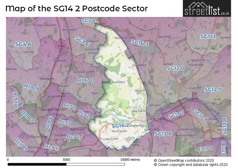
The SG14 2 Postcode shares a border with SG13 8 (HERTFORD, Bayford, Brickendon), SG2 8 (STEVENAGE), SG3 6 (KNEBWORTH, Woolmer Green, Datchworth), SG14 1 (HERTFORD), SG14 3 (HERTFORD, Watton At Stone, Stapleford), AL6 0 (WELWYN, Tewin, Digswell), AL7 2 (WELWYN GARDEN CITY), AL7 4 (WELWYN GARDEN CITY), AL9 5 (HATFIELD, Essendon, North Mymms) and AL9 6 (Essendon, HATFIELD, BROOKMANS PARK).
The sector is within the post town of HERTFORD.
SG14 2 is a postcode sector within the SG14 postcode district which is within the SG Stevenage postcode area.
The Royal Mail delivery office for the SG14 2 postal sector is the Hertford Delivery Office.
The area of the SG14 2 postcode sector is 13.17 square miles which is 34.11 square kilometres or 8,428.00 square acres.
Waterways within the SG14 2 postcode sector include the River Lea, River Mimram, Beane, River Beane.

Map of the SG14 2 Postcode Sector
Explore the SG14 2 postcode sector by using our free interactive map.
| S | G | 1 | 4 | - | 2 | X | X |
| S | G | 1 | 4 | Space | 2 | Letter | Letter |
Official List of Streets
HERTFORD (72 Streets)
Waterford (7 Streets)
Cole Green (3 Streets)
Bramfield (6 Streets)
Letty Green (4 Streets)
Birch Green (2 Streets)
Stapleford (1 Streets)
Hertingfordbury (6 Streets)
Watton At Stone (2 Streets)
Unofficial Streets or Alternative Spellings
HERTFORD
LINFIELD COURTWatton At Stone
CHURCH LANE GATEKEEPERS WAY GRESLEY CLOSE STATION ROAD STONEY FIELDSTewin
ARCHERS GREEN LANE HERTFORD ROAD TEWIN HILLDatchworth
RAFFIN GREEN LANE WATTON ROADDigswell
HERTFORD ROADWELWYN GARDEN CITY
COLE GREEN LANEWeather Forecast for SG14 2
Press Button to Show Forecast for Hertford
| Time Period | Icon | Description | Temperature | Rain Probability | Wind |
|---|---|---|---|---|---|
| 18:00 to 21:00 | Cloudy | 8.0°C (feels like 6.0°C) | 11.00% | NNE 7 mph | |
| 21:00 to 00:00 | Cloudy | 6.0°C (feels like 5.0°C) | 7.00% | NE 4 mph |
Press Button to Show Forecast for Hertford
| Time Period | Icon | Description | Temperature | Rain Probability | Wind |
|---|---|---|---|---|---|
| 00:00 to 03:00 | Cloudy | 5.0°C (feels like 3.0°C) | 3.00% | NE 4 mph | |
| 03:00 to 06:00 | Clear night | 3.0°C (feels like 1.0°C) | 1.00% | NE 4 mph | |
| 06:00 to 09:00 | Sunny day | 3.0°C (feels like 1.0°C) | 1.00% | NNE 4 mph | |
| 09:00 to 12:00 | Partly cloudy (day) | 8.0°C (feels like 6.0°C) | 1.00% | ENE 7 mph | |
| 12:00 to 15:00 | Cloudy | 10.0°C (feels like 9.0°C) | 9.00% | ENE 4 mph | |
| 15:00 to 18:00 | Overcast | 11.0°C (feels like 10.0°C) | 12.00% | NE 4 mph | |
| 18:00 to 21:00 | Cloudy | 9.0°C (feels like 8.0°C) | 10.00% | ENE 7 mph | |
| 21:00 to 00:00 | Cloudy | 6.0°C (feels like 4.0°C) | 9.00% | E 7 mph |
Press Button to Show Forecast for Hertford
| Time Period | Icon | Description | Temperature | Rain Probability | Wind |
|---|---|---|---|---|---|
| 00:00 to 03:00 | Cloudy | 5.0°C (feels like 3.0°C) | 11.00% | ENE 4 mph | |
| 03:00 to 06:00 | Cloudy | 4.0°C (feels like 2.0°C) | 15.00% | ENE 7 mph | |
| 06:00 to 09:00 | Overcast | 5.0°C (feels like 2.0°C) | 24.00% | NE 7 mph | |
| 09:00 to 12:00 | Cloudy | 9.0°C (feels like 7.0°C) | 19.00% | ENE 9 mph | |
| 12:00 to 15:00 | Overcast | 11.0°C (feels like 9.0°C) | 19.00% | E 9 mph | |
| 15:00 to 18:00 | Cloudy | 12.0°C (feels like 10.0°C) | 18.00% | E 11 mph | |
| 18:00 to 21:00 | Cloudy | 11.0°C (feels like 9.0°C) | 19.00% | ENE 9 mph | |
| 21:00 to 00:00 | Light rain | 9.0°C (feels like 6.0°C) | 49.00% | NE 11 mph |
Press Button to Show Forecast for Hertford
| Time Period | Icon | Description | Temperature | Rain Probability | Wind |
|---|---|---|---|---|---|
| 00:00 to 03:00 | Light rain | 9.0°C (feels like 6.0°C) | 53.00% | NE 9 mph | |
| 03:00 to 06:00 | Heavy rain | 9.0°C (feels like 7.0°C) | 75.00% | ESE 9 mph | |
| 06:00 to 09:00 | Light rain | 9.0°C (feels like 7.0°C) | 52.00% | SE 9 mph | |
| 09:00 to 12:00 | Heavy rain shower (day) | 11.0°C (feels like 9.0°C) | 60.00% | ESE 9 mph | |
| 12:00 to 15:00 | Light rain | 12.0°C (feels like 10.0°C) | 58.00% | S 9 mph | |
| 15:00 to 18:00 | Light rain shower (day) | 13.0°C (feels like 11.0°C) | 39.00% | SSW 11 mph | |
| 18:00 to 21:00 | Cloudy | 12.0°C (feels like 10.0°C) | 15.00% | SW 11 mph | |
| 21:00 to 00:00 | Partly cloudy (night) | 9.0°C (feels like 7.0°C) | 5.00% | SW 9 mph |
Schools and Places of Education Within the SG14 2 Postcode Sector
Hertford St Andrew CofE Primary School
Voluntary controlled school
Calton Avenue, Hertford, Hertfordshire, SG14 2EP
Head: Ms Rebecca Sutherland Cooper
Ofsted Rating: Good
Inspection: 2019-01-23 (1919 days ago)
Website: Visit Hertford St Andrew CofE Primary School Website
Phone: 01992583105
Number of Pupils: 139
Hertingfordbury Cowper Primary School
Voluntary aided school
Birch Green, Hertford, Hertfordshire, SG14 2LR
Head: Miss Lorraine Gauld
Ofsted Rating: Good
Inspection: 2019-05-22 (1800 days ago)
Website: Visit Hertingfordbury Cowper Primary School Website
Phone: 01992583239
Number of Pupils: 223
Hollybush Primary School
Community school
Fordwich Rise, Hertford, Hertfordshire, SG14 2DF
Head: Mrs Valerie Noon
Ofsted Rating: Good
Inspection: 2019-06-20 (1771 days ago)
Website: Visit Hollybush Primary School Website
Phone: 01992581454
Number of Pupils: 222
The Sele School
Academy converter
Welwyn Road, Hertford, Hertfordshire, SG14 2DG
Head: Mr Christopher Quach
Ofsted Rating: Requires improvement
Inspection: 2022-10-19 (554 days ago)
Website: Visit The Sele School Website
Phone: 01992581455
Number of Pupils: 423
House Prices in the SG14 2 Postcode Sector
| Type of Property | 2018 Average | 2018 Sales | 2017 Average | 2017 Sales | 2016 Average | 2016 Sales | 2015 Average | 2015 Sales |
|---|---|---|---|---|---|---|---|---|
| Detached | £888,408 | 20 | £905,281 | 16 | £810,821 | 15 | £774,004 | 28 |
| Semi-Detached | £502,597 | 41 | £514,375 | 24 | £476,146 | 30 | £396,067 | 21 |
| Terraced | £435,427 | 56 | £362,340 | 47 | £354,013 | 69 | £323,083 | 48 |
| Flats | £242,625 | 16 | £228,976 | 21 | £314,633 | 25 | £242,267 | 23 |
Important Postcodes SG14 2 in the Postcode Sector
SG14 2BU is the postcode for St. Josephs RC Primary School, North Road, and St. Joseph's Catholic Primary School, North Road
SG14 2DF is the postcode for Hollybush Primary School, Fordwich Rise
SG14 2DG is the postcode for The Sele School, Welwyn Road, and THE SELE SCHOOL, WELWYN ROAD, HERTFORD
SG14 2EP is the postcode for Hertford St. Andrews C of E Primary School, Calton Avenue
SG14 2LR is the postcode for Hertingfordbury Cowper Primary School, Birch Green
| The SG14 2 Sector is within these Local Authorities |
|
|---|---|
| The SG14 2 Sector is within these Counties |
|
| The SG14 2 Sector is within these Water Company Areas |
|