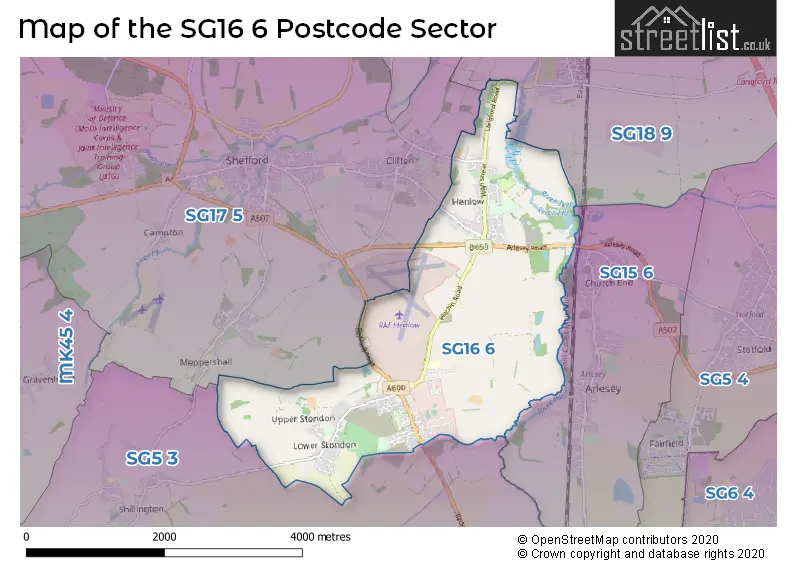
The SG16 6 postcode sector stands on the Bedfordshire and Hertfordshire border.
Did you know? According to the 2021 Census, the SG16 6 postcode sector is home to a bustling 6,871 residents!
Given that each sector allows for 400 unique postcode combinations. Letters C, I, K, M, O and V are not allowed in the last two letters of a postcode. With 179 postcodes already in use, this leaves 221 units available.
The largest settlement in the SG16 6 postal code is HENLOW followed by Lower Stondon, and Upper Stondon.
The SG16 6 Postcode shares a border with SG15 6 (ARLESEY), SG17 5 (SHEFFORD, Clifton, Meppershall), SG18 9 (Langford, Upper Caldecote, Broom) and SG5 3 (Ickleford, Shillington, Pirton).
The sector is within the post town of HENLOW.
SG16 6 is a postcode sector within the SG16 postcode district which is within the SG Stevenage postcode area.
The Royal Mail delivery office for the SG16 6 postal sector is the Henlow Camp Scale Payment Delivery Office.
The area of the SG16 6 postcode sector is 5.18 square miles which is 13.42 square kilometres or 3,315.12 square acres.
Waterways within the SG16 6 postcode sector include the River Ivel, River Hiz.

Map of the SG16 6 Postcode Sector
Explore the SG16 6 postcode sector by using our free interactive map.
| S | G | 1 | 6 | - | 6 | X | X |
| S | G | 1 | 6 | Space | 6 | Letter | Letter |
Official List of Streets
HENLOW (87 Streets)
Lower Stondon (49 Streets)
Upper Stondon (5 Streets)
Henlow Camp (1 Streets)
Unofficial Streets or Alternative Spellings
Lower Stondon
ALTON ROADMeppershall
HITCHIN ROAD STONDON ROAD DERWENT LOWER SCHOOL HENLOW ROAD LONG CLOSE MILLENIUM MEADOW BRIDGE OLD VICARAGE GARDENS THE MALTINGS TILLY PLACE TOWN FARMClifton
BROAD STREET STOCKBRIDGE ROADHolwell Bury
BEDFORD ROADWeather Forecast for SG16 6
Press Button to Show Forecast for Shefford
| Time Period | Icon | Description | Temperature | Rain Probability | Wind |
|---|---|---|---|---|---|
| 03:00 to 06:00 | Cloudy | 5.0°C (feels like 3.0°C) | 4.00% | SW 7 mph | |
| 06:00 to 09:00 | Cloudy | 5.0°C (feels like 3.0°C) | 4.00% | WSW 7 mph | |
| 09:00 to 12:00 | Cloudy | 8.0°C (feels like 6.0°C) | 43.00% | W 9 mph | |
| 12:00 to 15:00 | Cloudy | 9.0°C (feels like 7.0°C) | 17.00% | W 9 mph | |
| 15:00 to 18:00 | Cloudy | 9.0°C (feels like 6.0°C) | 42.00% | NNW 11 mph | |
| 18:00 to 21:00 | Cloudy | 7.0°C (feels like 5.0°C) | 10.00% | NE 7 mph | |
| 21:00 to 00:00 | Partly cloudy (night) | 5.0°C (feels like 4.0°C) | 1.00% | ENE 4 mph |
Press Button to Show Forecast for Shefford
| Time Period | Icon | Description | Temperature | Rain Probability | Wind |
|---|---|---|---|---|---|
| 00:00 to 03:00 | Clear night | 3.0°C (feels like 2.0°C) | 1.00% | NE 4 mph | |
| 03:00 to 06:00 | Clear night | 2.0°C (feels like -1.0°C) | 1.00% | NE 4 mph | |
| 06:00 to 09:00 | Sunny day | 2.0°C (feels like 0.0°C) | 1.00% | NNE 4 mph | |
| 09:00 to 12:00 | Partly cloudy (day) | 7.0°C (feels like 5.0°C) | 1.00% | NE 7 mph | |
| 12:00 to 15:00 | Cloudy | 10.0°C (feels like 9.0°C) | 7.00% | NE 7 mph | |
| 15:00 to 18:00 | Overcast | 11.0°C (feels like 10.0°C) | 12.00% | NE 4 mph | |
| 18:00 to 21:00 | Cloudy | 9.0°C (feels like 7.0°C) | 10.00% | ENE 7 mph | |
| 21:00 to 00:00 | Cloudy | 5.0°C (feels like 4.0°C) | 10.00% | ENE 4 mph |
Press Button to Show Forecast for Shefford
| Time Period | Icon | Description | Temperature | Rain Probability | Wind |
|---|---|---|---|---|---|
| 00:00 to 03:00 | Cloudy | 4.0°C (feels like 2.0°C) | 11.00% | ENE 4 mph | |
| 03:00 to 06:00 | Cloudy | 3.0°C (feels like 1.0°C) | 14.00% | ENE 7 mph | |
| 06:00 to 09:00 | Cloudy | 4.0°C (feels like 2.0°C) | 21.00% | NE 7 mph | |
| 09:00 to 12:00 | Cloudy | 9.0°C (feels like 6.0°C) | 22.00% | ENE 9 mph | |
| 12:00 to 15:00 | Cloudy | 11.0°C (feels like 9.0°C) | 18.00% | E 9 mph | |
| 15:00 to 18:00 | Cloudy | 12.0°C (feels like 10.0°C) | 21.00% | ENE 11 mph | |
| 18:00 to 21:00 | Cloudy | 11.0°C (feels like 8.0°C) | 19.00% | ENE 9 mph | |
| 21:00 to 00:00 | Light rain | 8.0°C (feels like 5.0°C) | 54.00% | NE 11 mph |
Press Button to Show Forecast for Shefford
| Time Period | Icon | Description | Temperature | Rain Probability | Wind |
|---|---|---|---|---|---|
| 00:00 to 03:00 | Heavy rain | 8.0°C (feels like 5.0°C) | 75.00% | NE 11 mph | |
| 03:00 to 06:00 | Heavy rain | 8.0°C (feels like 6.0°C) | 77.00% | ENE 9 mph | |
| 06:00 to 09:00 | Light rain shower (day) | 9.0°C (feels like 7.0°C) | 43.00% | SE 9 mph | |
| 09:00 to 12:00 | Light rain | 10.0°C (feels like 8.0°C) | 54.00% | ESE 9 mph | |
| 12:00 to 15:00 | Light rain shower (day) | 11.0°C (feels like 9.0°C) | 44.00% | SE 11 mph | |
| 15:00 to 18:00 | Light rain shower (day) | 13.0°C (feels like 11.0°C) | 42.00% | S 11 mph | |
| 18:00 to 21:00 | Light rain shower (day) | 11.0°C (feels like 9.0°C) | 34.00% | WSW 11 mph | |
| 21:00 to 00:00 | Cloudy | 9.0°C (feels like 7.0°C) | 9.00% | WSW 7 mph |
Schools and Places of Education Within the SG16 6 Postcode Sector
Derwent Primary School
Foundation school
Hitchin Road, Henlow, Bedfordshire, SG16 6BA
Head: Mrs Samantha Barlow
Ofsted Rating: Good
Inspection: 2023-07-12 (288 days ago)
Website: Visit Derwent Primary School Website
Phone: 01462812047
Number of Pupils: 247
Henlow Church of England Academy
Academy converter
Church Road, Henlow, Bedfordshire, SG16 6AN
Head: Mrs Caren Earp
Ofsted Rating: Good
Inspection: 2019-09-12 (1687 days ago)
Website: Visit Henlow Church of England Academy Website
Phone: 01462813733
Number of Pupils: 569
Raynsford Church of England Academy
Academy converter
Park Lane, Henlow, Bedfordshire, SG16 6AT
Head: Mr Ed Wheatley
Ofsted Rating: Good
Inspection: 2018-10-31 (2003 days ago)
Website: Visit Raynsford Church of England Academy Website
Phone: 01462812319
Number of Pupils: 238
Stondon Lower School
Community school
Hillside Road, Henlow, Bedfordshire, SG16 6LQ
Head: Miss Sarah Woodham
Ofsted Rating: Good
Inspection: 2022-11-10 (532 days ago)
Website: Visit Stondon Lower School Website
Phone: 01462850288
Number of Pupils: 142
House Prices in the SG16 6 Postcode Sector
| Type of Property | 2018 Average | 2018 Sales | 2017 Average | 2017 Sales | 2016 Average | 2016 Sales | 2015 Average | 2015 Sales |
|---|---|---|---|---|---|---|---|---|
| Detached | £462,610 | 18 | £497,757 | 33 | £477,260 | 42 | £411,973 | 69 |
| Semi-Detached | £334,417 | 31 | £325,002 | 22 | £313,802 | 37 | £279,904 | 32 |
| Terraced | £294,422 | 32 | £246,641 | 32 | £267,897 | 44 | £210,412 | 122 |
| Flats | £190,000 | 2 | £0 | 0 | £153,000 | 3 | £179,000 | 2 |
Important Postcodes SG16 6 in the Postcode Sector
SG16 6AN is the postcode for FOUR COURTS / NEW BUILDING, Henlow Church of England Academy, Church Road, and Henlow Church of England Academy, Church Road
SG16 6AT is the postcode for RAYNSFORD C OF E ACADEMY, PARK LANE, Raynsford C of E Academy Main, Park Lane, and Raynsford C of E Academy Owlery, Park Lane
SG16 6BA is the postcode for Derwent Lower School, Hitchin Road
SG16 6DN is the postcode for RAF Henlow, and SPORTS CENTRE BUILDING 188 RAF HENLOW, RAF Henlow
| The SG16 6 Sector is within these Local Authorities |
|
|---|---|
| The SG16 6 Sector is within these Counties |
|
| The SG16 6 Sector is within these Water Company Areas |
|